VDR is a marine recording device that functions like an aircraft's black box, recording critical ship data and communications to help investigators determine the cause of accidents. A VDR continuously records data from navigational equipment, alarms, and communications for at least 12 hours. This data is stored in a protective capsule that can withstand fire and deep water immersion. Accessing and analyzing VDR data after an incident allows for faster, more accurate investigations that help improve safety. VDR recordings have also assisted ship owners in assessing bridge team performance and identifying areas for improvement.
Presentation on maneuvering and collision avoidance with special focus on large tonnage vessels.
Maneuverability limits and last moment maneuver are thoroughly shown in this material.
The document provides an overview of key rules and definitions from the Navigation Rules for Marine Law Enforcement Officers. It defines terms like vessel, underway, power-driven and sailing vessels. It outlines lighting requirements and sound signals. It discusses rules for determining risk of collision, taking action to avoid collision, operating in narrow channels, overtaking situations, head-on encounters, and crossing situations.
The document provides an overview of international and inland nautical rules of the road. It discusses key topics such as required navigation lights for vessels, sound signals, and right-of-way rules for different vessel encounter situations such as meeting, overtaking, and crossing. Specific lights, shapes, and whistle signals that vessels must use to identify themselves and communicate intentions are described.
The document discusses mooring operations for ships and outlines several important considerations. It notes that mooring operations require coordination between the forward team, aft team, and bridge personnel. Aspects that should be planned include the berth nature, available bollards, tide, windage, cargo operations, potential tug use, and mooring line order. A detailed briefing must inform all crew members involved prior to commencement. Safety precautions include use of PPE, supervision of inexperienced crew, and avoidance of snapback zones during operations.
The Global Maritime Distress and Safety System (GMDSS) automates distress alerting and provides for improved safety communications at sea. Under GMDSS, search and rescue authorities and nearby ships will be rapidly alerted to a ship in distress through shore-based coordination. GMDSS also transmits maritime safety information. Ships are equipped according to the communication capabilities required for the area in which they operate, divided into Sea Areas 1 through 4 with varying coverage ranges. GMDSS aims to speed rescue responses and improve safety of ships and their crews over previous manual systems.
The document provides guidance on properly handing over and taking over the navigational watch. It states that the officer of the watch should not hand over the watch if the relieving officer is incapable, and the relieving officer must ensure all crew members are capable of performing their duties. The relieving officer must also satisfy themselves on the safety of the vessel before taking over the watch. Proper lookout, navigation with pilots, and environmental protection are also discussed.
This document summarizes the key provisions of MARPOL 73/78, the main international convention covering prevention of pollution of the marine environment by ships. It outlines the six annexes of MARPOL which cover pollution by oil, noxious liquid substances, harmful substances carried by sea in packaged form, sewage, garbage, and air pollution. For each annex, it provides details on entry into force date, prohibited discharge criteria, record keeping and equipment requirements such as oil filtering and sewage treatment systems.
This document provides an overview of shiphandling theory and practices. It covers key topics such as laws of motion, controllable and uncontrollable forces acting on a ship, terminology, ground tackle, mooring, getting underway, single and twin screw characteristics, standard commands between the conning officer and helm, and maneuvering considerations. The document is intended to teach the essential information needed for shiphandling watches and operations.
This cargo securing manual provides guidelines for securing cargo on board the MV Tropical Estoril. [1] It describes the vessel as having no fixed cargo securing devices and being designed solely for carriage of refrigerated cargo in insulated holds. [2] Portable securing devices are not required for the banana boxes typically carried as individual unit loads with block stowage. [3] Any future modifications requiring additional securing points would need to ensure the ship's structure can withstand the added loads.
This document defines and explains various ship measurement terms used in the shipping industry. It discusses tonnage measurements including deadweight tonnage, cargo tonnage, gross tonnage, net tonnage, and displacement tonnage. It also covers bunker fuel, deadweight cargo capacity, deadweight all told, water lines, lightering, the roles of stevedores, and provides examples of how these measurements are used.
This document provides instructions for identifying key terms related to loadlines and draft marks on a ship. It describes the location and purpose of the loadline disk, summer and winter loadlines, summer and tropical draft marks, timber loadlines, freeboard, and draft readings. The terms are related to regulating a ship's loading and determining its draft and tonnage in both fresh and salt water.
This document discusses various aspects of seamanship and marine navigation. It begins by defining seamanship as the art possessed by seafarers to safely operate ships at sea. Seamanship is evolutionary as skills are acquired over time through experience, and dynamic as the skills needed vary between roles and adapt with new technology. The document then discusses four main types of navigation: piloting, dead reckoning, celestial navigation, and radio navigation. It also defines key terms used in marine navigation like the prime meridian, nautical mile, magnetic north versus true north. The document provides diagrams and descriptions of the key parts of a research vessel and typical ship. It concludes by classifying ships according to their purposes and support types.
The document provides guidance on passage planning for ships. It discusses key terms, guidelines and components to consider when creating a passage plan. The main components are appraisal, planning, execution and monitoring. Appraisal involves considering relevant information about the ship, cargo, crew, and voyage. Planning includes plotting the intended route on charts and noting safety elements. Execution is conducting the passage according to the plan, adjusting as needed. Monitoring involves checking progress and equipment performance against the plan. The overall purpose is to ensure safe and efficient navigation while protecting the environment.
This document discusses navigation and collision avoidance in restricted visibility. It outlines key rules for vessel conduct when visibility is limited, including proceeding at a safe speed and having engines ready. Parallel indexing is described as the primary method for monitoring navigation using radar to track fixed objects and course changes. The document also details the sound signals vessels must use in restricted visibility, such as one prolonged blast for power-driven vessels making way through water. Maintaining accurate position information and pre-planning routes can additionally aid safe navigation in poor conditions.
This document summarizes key aspects of MARPOL Annexes I-V, which regulate pollution from ships. Annex I covers oil pollution and impacts ship design requirements like double hulls and oil filtering equipment. Annex II covers noxious liquid substances carried in bulk. Annex III covers harmful substances carried by sea in packaged form. Annex IV regulates sewage pollution and requires ships to have sewage treatment plants or holding tanks. Annex V addresses garbage pollution from ships and prohibits most plastics from being discharged. The annexes establish pollution control zones, certification requirements, and penalties for non-compliance.
Marine radars are short range radars used by ships to locate other vessels and land areas. They operate at X-band or S-band frequencies. Radars detect objects by transmitting radio pulses and measuring the time it takes for the pulses to return after reflecting off surfaces. The detected reflections are displayed on the radar screen to help navigate safely and avoid collisions with other ships. Marine radars also incorporate features like zoom functions, automatic gain control, and target tracking to enhance navigation and situational awareness capabilities.
This document provides instructions for plotting radar targets over a 6 minute interval to determine course, speed, closest point of approach (CPA), and time to CPA (TCPA) of other vessels. It outlines the steps to mark initial bearing and range, draw target movement line, transfer own vessel movement, calculate distances traveled, and determine other vessel's course, speed, CPA and TCPA. It concludes that in this example, if no course or speed changes are made, there will be a collision at a CPA of 0.0 nautical miles at 12:09:48, and that the observer is the give-way vessel in a crossing situation.
SOLAS is the most important international treaty concerning maritime safety. It establishes minimum standards for the construction, equipment and operation of ships. SOLAS has undergone revisions and amendments over time to keep up with technological and operational advances. Key provisions address subdivision and stability, fire safety, life-saving appliances, safe navigation, dangerous cargo carriage, and ship security. SOLAS requires certifications and has different technical requirements depending on ship type and cargo. Its goal is to specify uniform safety standards to ensure ships remain safe and secure at sea.
This document discusses regulations and procedures for safely carrying grain cargo. It covers types of grain, dangers of grain shifting, requirements of the International Code for the Safe Carriage of Grain, documents required for loading, and methods for securing grain in fully and partially filled compartments including longitudinal subdivisions, overstowing with bags, and covering surfaces with tarps and securing with lashings or wire mesh.
The document discusses emergency position indicating radio beacons (EPIRBs) and search and radar transponders (SARTs) that are used in search and rescue operations. It describes how 406 MHz satellite EPIRBs transmit a radio signal every 50 seconds that includes a digitally encoded message with information to help locate the vessel in distress. SARTs generate a response signal when interrogated by ship or aircraft radar to help rescuers locate survivors in the water even in poor visibility. The document outlines key performance parameters for EPIRBs such as detection probability, location accuracy, ambiguity resolution, system capacity, coverage area, and notification times.
This document provides an overview of differential GPS (DGPS) and its history. It explains that DGPS uses fixed, ground-based reference stations to broadcast corrections to improve GPS accuracy from 15 meters to about 10 cm. Selective availability was introduced by the US military to degrade civilian GPS but was turned off in 2000. DGPS was developed as a solution, broadcasting corrections to offset errors and allow 5 meter accuracy, meeting most civilian needs. It has expanded to cover many waterways through systems like the US Coast Guard's National DGPS.
This document provides an overview of the International Convention for the Safety of Life at Sea (SOLAS). It discusses the history and purpose of SOLAS, including that it was first adopted in 1914 in response to the Titanic disaster. It outlines the key chapters and requirements of SOLAS, including those relating to construction, fire protection, life-saving appliances, safety of navigation, and carriage of dangerous goods. Specifically for liquid petroleum gas carriers like the presenter's uncle's ship, it notes the regulations that must be followed are in Chapter VII Part C and comply with the International Gas Carrier Code.
Stuff about people falling overboard on a boat while on the water. Created for the US Navy by myself. They didnt like this one much either.
Man overboard is serious fucking business petty officer doebelin.
This document summarizes various marine operations including towing, mooring, handling heavy loads at sea, personnel transfer, diving, remote operated vehicles, and underwater construction activities. It discusses the equipment, considerations, and methods used for each type of operation. Towing operations require strong attachments that can withstand dynamic loads. Mooring uses anchors and mooring lines to secure vessels. Personnel transfer faces challenges of transferring people safely between moving vessels in sea states. Diving and ROVs allow underwater inspection and intervention.
This document provides information about navigational charts and publications. It discusses different map projections used for charts, including Mercator, Transverse Mercator, and Gnomonic projections. It also covers topics like the requirements of a navigational chart, reliability of chart data based on survey dates, chart corrections via Notices to Mariners, and common navigational publications. The purpose is to outline key aspects for mariners to understand about charts and navigational resources.
This document discusses the effects of shallow and restricted water on ships, including increased sinkage, trim, and resistance. It describes how squat, the combined sinkage and trim effect, increases sharply with ship speed. Empirical formulas are provided to estimate squat in canals and unrestricted shallow water. The changes to wave patterns and resistance at various ship speeds relative to the critical wave speed are also summarized.
The document discusses the International Convention on Load Lines of 1966 which establishes uniform principles and rules regarding load lines on ships involved in international voyages. It outlines the requirements for assigning freeboards based on zones and seasons, surveying and certifying ships, marking load lines on ships, and other provisions to ensure ships are properly loaded for safety and stability in various weather conditions around the world. The convention aims to determine safe limits of load lines for ships to maintain adequate freeboard and prevent overloading.
VDR is a marine recording device similar to an aircraft's black box. It records critical ship parameters and operations data to help investigators determine the cause of accidents. A VDR consists of microphones, a main unit that receives and stores data, a power supply, and a voyage data capsule that stores the last 12 hours of data. The capsule is designed to withstand impacts, fire, and deep water pressure. VDR data can help make accident investigations faster and more accurate by providing an objective account of events. Ship owners retain ownership of VDR data but investigators have custody during investigations.
NAVIGATION AIDS GROUP 3 for topic 2-Final.pptxssuserdc25cd
This document discusses voyage data recorders (VDRs), also known as ship black boxes. It provides information on:
- What a VDR is and its main purpose of providing an accurate record of ship data to aid in accident investigations.
- How a VDR works, including that it has a data collection unit that pulls in data from integrated sources and a data recording unit that stores the data in a protective capsule.
- Carriage requirements for VDRs and simplified VDRs (S-VDRs) based on ship size and characteristics.
- General operational requirements for VDR data recording, testing, and maintenance to ensure proper functioning.
1. The purpose of a simplified voyage data recorder (S-VDR) is to securely store information about a vessel's position, movement, status, and command in the event of an incident for use in subsequent investigations.
2. Ships defined in SOLAS Chapter V must be fitted with an S-VDR that continuously records preselected data items relating to ship status, equipment output, and command/control. The data must be time-correlated and stored in a tamper-proof capsule for at least 2 years.
3. An S-VDR must record data items including date, time, position, speed, heading, bridge audio, communications audio, radar data, and AIS data
Renice CF card for VDR (Voyage Data Recorder) applicationMay Lau
Voyage Data Recorders (VDRs) continuously record ship data including communications, sensors, alarms, and radar images. As VDRs expand their data collection and increase recording time, larger storage capacity is needed. Choosing a reliable storage solution is crucial given the harsh ship environment and electromagnetic interference. Renice Compact Flash cards are designed to work from -40°C to +85°C, resist vibration and dust, and provide power failure protection, making them well-suited for VDR applications requiring high reliability.
The document summarizes an L-VDR (voyage data recorder) and Voyage Performance Analyser software. The L-VDR is described as the "blackbox" that stores all available ship's data with very low power consumption. It makes use of onboard navigation electronics to precisely collect data. The Voyage Performance Analyser software processes ship's data from L-VDR or other sources to provide trip documentation, match analysis, and presentations in Google Earth format with automatic alerts and analysis of ship performance and polar. Examples are given of past races and alerts visualized in the software.
Applications of offshore monitoring are applied in reducing the risk of oil spills, monitoring weather at the pilot station of a port, security application, mitigating the prospect of terrorist attacks, monitoring of thermal effluents from coastal power plants etc. In this the data is stored and it can be retrieved according to user’s needs. This article throws light on the offshore monitoring technology and discusses the use of buoys equipped with sensors, cameras and lidar to monitor conditions like weather, security threats, and environmental factors offshore. Data is transmitted periodically depending on the application, either in real-time or stored for later retrieval. Portable lidar buoys are also described that can measure wind speed at different heights to assess wind
This document provides guidance on assembling an emergency grab bag for small fishing vessels and boats. It recommends including the following essential safety equipment: 1) a floating grab bag to store all items; 2) manual inflatable lifejackets; 3) a sea rescue streamer, whistle, mirror, and rescue laser for signaling; 4) a personal locator beacon, strobe light, and batteries; 5) a compass; 6) emergency blankets; 7) a mobile phone; 8) a handheld VHF radio; 9) a handheld GPS; and 10) a medical kit. It also suggests bringing a sea anchor or drogue to slow drift, as well as extra food, water, and tools. The goal
This document provides information about Dr. M Akbar Marwan, including his education history, occupation, organizations, certifications, and contact information. It also includes summaries and diagrams of drone anatomy, components of quadcopters, drone flight controllers, and potential sources of evidence from drones.
Transportation Event Data Recorders paper presented at the World Accident Reconstruction Exposition WREX 2000. Paper addresses EDR use in aviation, rail, ship, pipeline and highway transportation modes and specific recent developments in highway EDR.
The document describes a proposed underwater drone capable of detecting and detonating naval mines. The drone would use sonar and cameras to detect mines and other objects underwater. It would be remotely controlled from a surface vessel via a long cable to allow it to cover large areas. The drone would be constructed from non-metallic PVC to avoid detection by mines that detect magnetic fields. It would have thrusters to maneuver and depth controls. Upon detecting a mine, it could either detonate itself next to the mine or detach the mine's cables to render it harmless. The drone aims to provide a safer alternative to existing minesweeping methods.
Laid up vessel reactivation guide- West of EnglandDeva RG
This document provides guidance on reactivating a vessel that has been in long-term layup. It stresses the importance of thorough documentation during layup, including layup logs detailing any work done and blanking plates installed. Careful planning is needed to ensure key crew are available, required spares have been ordered, and safety equipment is in working condition before reactivation begins. Classification societies and insurers will require surveys be conducted before the vessel can resume trading.
This document provides an overview of a navigation bridge course on managing bridge resources. It discusses key equipment used on the navigation bridge such as radar and AIS systems. It emphasizes the importance of the officer of the watch being familiar with the operation and maintenance of all bridge equipment. Periodic checks of equipment should be performed and defects should be recorded. The document also outlines best practices for using radar and AIS to assist with navigation and collision avoidance.
This document discusses a navigational bridge course that covers the management of bridge resources. It provides details on course leadership and topics to be covered, including bridge equipment operation and maintenance. Specific sections focus on the proper use and monitoring of radar and AIS systems, emphasizing the importance of familiarity with equipment, regular checks, and incorporating the technology into safe watchkeeping practices.
Oil Detection among Ice and Snow_Lessons learned_Sassi_Rytkönen 24 March 2015Jukka Sassi
This document summarizes lessons learned from an Arctic oil recovery exercise in Kemi, Finland. It discusses various technologies for detecting oil among ice and snow, including passive optical sensors, thermal infrared sensors, radar sensors, and active laser and fluorosensors. It also reviews different deployment platforms like satellites, aircraft, unmanned aerial vehicles, surface vessels, and autonomous underwater vehicles. The document concludes that a flexible combination of sensors across multiple platforms is recommended for Arctic oil spill response and identifies some of the main challenges around detecting oil in ice-filled conditions. Plans are also announced to test new sensor technologies in field experiments in northern Finland in 2016.
Unmanned aerial vehicles (UAVs), also known as drones, provide a low-cost platform for aerial photography, mapping, and remote sensing applications. They can carry various sensor payloads and be used for infrastructure inspection, wildlife monitoring, search and rescue operations, and more. Regulations currently require certification to operate drones commercially, but their utility is driving efforts to expand approved uses. This document discusses various drone types, payloads, examples of applications, and the training and equipment required.
This document provides a checklist for ship crews to use to prepare for port state control inspections and reduce the risk of detention. It lists the most common deficiencies found during past inspections of ships classed by Lloyd's Register. The checklist covers items in the master's office, on the bridge, life-saving appliances, accommodation, the deck area, working spaces, and the engine room. It also provides guidance on factors that increase a ship's likelihood of being targeted for inspection. Using this checklist can help ensure documentation and equipment are in order before arriving at port.
The document discusses unit load devices (ULDs) used in cargo transportation by airlines. It covers several topics:
1. It defines ULDs as devices that help consolidate smaller cargo items into single loads for easier handling. Common ULD types are pallets and containers.
2. Proper handling and storage of ULDs is important as they are part of the aircraft's airworthiness when loaded. Carriers also closely track ULDs as they move throughout the network.
3. Detailed procedures are outlined for inspecting ULDs, preparing and building them, as well as properly storing and rotating stock between stations. Identification codes provide information on ULD category, size and aircraft compatibility
Topic 1.2- Electronic Equipment used on ships (Navigational Equipment).pptxMartMantilla1
Modern ships have a variety of navigation equipment that makes navigation simpler and safer than in the past. This includes gyro compasses, radar, magnetic compasses, autopilots, ARPA, automatic tracking aids, voyage data recorders, GPS receivers, sound reception systems, and navigational lights. Together, this navigation equipment provides accurate positioning and directional information and helps ships safely plan and conduct voyages.
1. The document outlines 23 performance standards that autopilot and heading control systems installed on ships must meet according to the International Maritime Organization (IMO).
2. The standards require systems to reliably maintain a preset heading under various operating conditions, incorporate controls to adjust for weather and steering performance, and allow for easy and safe operation.
3. Systems must also ensure the ship's heading can only be altered intentionally by crew, integrate properly with navigation systems, and include alarms and indications for failures or off-heading situations.
The document provides information on the International Aeronautical and Maritime Search and Rescue (IAMSAR) Manual. It discusses that IAMSAR is a joint publication of ICAO and IMO that assists states in meeting SAR needs and obligations under international conventions. It has three volumes that deal with specific SAR system duties and can be used independently or together. The document then provides definitions and explanations of key terms related to SAR operations, structures, and coordination.
This document outlines the International Maritime Organization's (IMO) performance standards for rate of turn indicators (ROTI) installed on ships. The ROTI must be capable of indicating port and starboard turns, have a means to verify operation, and use a center-zero analog dial indicator with positive indications for port and starboard turns. The scale must allow measurement of turns between -30 and 30 degrees per minute and meet accuracy standards for deviations from the actual turn rate under various ship motions and speeds.
The document outlines 17 performance standards that GPS receiver equipment installed on ships must meet in order to be compliant. The standards require the equipment to:
1) Be capable of receiving and processing GPS signals to provide position, latitude and longitude, in the WGS-84 coordinate system and UTC time within specified accuracies and update rates.
2) Have static and dynamic position accuracy of 100m or less depending on whether differential GPS corrections are applied.
3) Generate and output position, course, speed, and time data at least once per second and interface with other navigation equipment.
4) Provide warnings if performance standards for position dilution or update rates are not met.
This document outlines the performance standards for echo-sounding equipment set by the International Maritime Organization (IMO). The equipment is intended to provide reliable depth readings between 2-200 meters to aid navigation, especially in shallow waters. It must have at least two depth ranges (20m and 200m scales), record soundings for 15 minutes, and be able to record depth and time for 12 hours. The display must show depth marks no more than 1/10 the range and time marks at most every 5 minutes. Alarms are required for shallow water and any failure affecting safe operation.
This document discusses an inclining test performed on a ship to determine its metacentric height (GM). It provides details of the test, including five shifts of weights totaling 216 tonnes that caused deflections of the ship ranging from 12 to 110 mm. It also shows the calculations to determine that the ship's GM as inclined is 1.68 m. Precautions for an accurate inclining test are noted, such as having a calm environment, securing loose weights, and restricting crew movement during the test.
The document discusses the relationships between a ship's speed, displacement, distance traveled, and fuel consumption. It states that daily fuel consumption varies as the cube of ship speed, as the 2/3 power of displacement, and as the square of speed multiplied by distance for a voyage. Examples are provided to demonstrate calculating new fuel consumption with changes in speed, displacement or distance. Specific fuel consumption is also defined as the fuel used per kilowatt hour of power.
An integrated bridge system (IBS) combines systems like the integrated navigation system (INS) to allow centralized monitoring and control of operations from the bridge like navigation, machinery control, safety, and security. An IBS provides benefits like enhanced decision making and workload reduction. Key components of an IBS include the navigation management system, alarm system, and conning display. Passage planning, position fixing, and track keeping can be automated if principles are followed, but overreliance on automation without watchkeeping can be dangerous. An IBS interconnects INS and other systems, while INS specifically combines navigational data and systems.
The document discusses autopilot systems and steering gear controls on ships. It provides details on:
- How autopilots work to automatically steer the ship and reduce workload in heavy weather by learning a ship's handling characteristics.
- The different control modes and settings used on autopilot control units, including proportional, integral, derivative controls and weather compensation settings.
- Limitations of autopilot use in rough conditions, tight spaces, slow speeds, or during maneuvers.
- Procedures for changing between manual and autopilot steering, testing equipment, and emergency steering protocols.
This document discusses Rate of Turn Indicator (ROTI), which is required on vessels over 50,000 GT per SOLAS regulations. ROTI assists the officer on watch in planning, executing, and monitoring a vessel's progress along a curved segment of its charted course. It provides the rate of turn to port and starboard in degrees per minute. The document derives the formula for ROT as the change in angle over time divided by the radius of the turn. It provides examples of using ROTI for constant radius and constant rate turns, and discusses wheel over points and planning turns.
1) ROTI (Rate of Turn Indicator) is an instrument that assists ship officers in planning, executing, and monitoring a vessel's progress along curved segments of its charted course. It indicates the rate of turn (in degrees per minute) to port or starboard.
2) For large vessels, turns must be executed along curved paths rather than sharp corners due to momentum and water friction. ROTI helps determine the radius and rate of turn needed based on factors like vessel size and speed.
3) There are two main turn types - constant radius, where the radius remains fixed and rate of turn varies, and constant rate, where the rate of turn remains fixed and the radius varies. The document provides
GPS satellites are positioned at an altitude of 20,200 km above the Earth's surface, which falls within medium Earth orbits. This height provides global coverage with a smaller number of satellites and allows earth-based transmitters and receivers to use modest sized antennas and lower transmission powers.
Gross tonnage refers to the total enclosed volume of a ship, while net tonnage refers to the cargo-carrying capacity. Both are determined by measuring volumes and applying formulas, and are dimensionless numbers rather than units of mass.
Radar performance can be ascertained using a performance monitor. 10 cm or S-band radar is generally better for long range scanning and in heavy rain due to less clutter.
The document contains several numerical problems related to marine gyrocompasses. It provides solutions to problems involving calculating the tilt and direction of a gyroscope's spin axis (SA) given its initial position and the latitude, passage of time, or a later observed position. One question calculates the percentage change in the moment of inertia (MOI) of a gyroscope rotor if its mass increases by 20% and radius of gyration decreases by 20%.
This document contains checklists for various emergency situations that may occur on ships, such as general emergencies, abandoning ship, search and rescue, rescuing crew from a disabled vessel, flooding, fire, stranding or grounding, collision, main engine failure, steering failure, rudder failure, and checklists for navigation in coastal and ocean waters. The checklists provide step-by-step instructions for crew to follow to ensure passenger and crew safety, assess damage, send distress signals, and follow proper emergency procedures in a variety of emergency situations at sea.
1. Atmospheric pressure is the pressure exerted by the weight of the earth's atmosphere. It is measured in hectopascals (hPa), with 1 hPa equal to 1 millibar.
2. Pressure gradient refers to the rate of change of pressure over distance and indicates how strongly winds will blow between areas of high and low pressure.
3. Dew point temperature is the temperature at which air becomes saturated with water vapor and fog can form. It is an important measurement for mariners to consider when deciding whether to ventilate cargo holds.
1. The document outlines International Maritime Organization performance standards for Bridge Navigational Watch Alarm Systems (BNWAS).
2. BNWAS monitors bridge activity and detects if the Officer of the Watch becomes incapacitated, alerting others. It has automatic, manual on, and manual off operational modes.
3. The system remains dormant for 3-12 minutes before initiating visual alerts. If not reset, it issues audible alarms to the bridge and then remotely to summon help. Resetting cancels alerts and restarts the dormant period.
1. An electromagnetic (EM) log works by inducing an electromotive force in sea water moving through the Earth's magnetic field using a solenoid, with the induced voltage proportional to water velocity.
2. The solenoid is housed in a streamlined flow sensor that extends below the ship's hull. Electrodes on either side of the sensor measure the voltage induced in the strip of sea water moving across the magnetic field.
3. This voltage corresponds to ship speed and is amplified and used to drive indicators showing speed in the wheelhouse. The EM log thus non-intrusively measures ship speed through water.
AIS aims to automatically identify vessels using electronic communication without human intervention. It works by having each vessel broadcast its identification and position using a transponder. Vessels are assigned time slots to transmit this data to avoid interference on the shared VHF channel. The time slots are precisely synchronized using GPS time signals. This allows many vessels to broadcast on the same frequency without interfering with each other. Vessels can then receive the identification and position of all other vessels within range, aiding navigation safety.
1) A marine gyrocompass uses a freely-spinning gyroscope to determine direction based on the principles of angular momentum and the earth's constant rotation.
2) A gyroscope has three degrees of freedom - it can spin about its axis and tilt or turn in horizontal and vertical planes. The earth acts like a giant free gyroscope due to its mass, high-speed rotation, and lack of friction in space.
3) The gyroscope's angular momentum and inertia cause it to resist changes to its axis of spin, allowing it to maintain a fixed direction in space independent of the ship's movements. This gyroscopic property is used to determine true north.
1. The document outlines performance standards for route planning, monitoring, and voyage recording functions of Electronic Chart Display and Information Systems (ECDIS).
2. It describes that ECDIS should allow for simple and reliable route planning including straight and curved segments as well as adjustments to planned routes. It should monitor the ship's position along the selected route and provide alarms if deviations occur.
3. For voyage recording, ECDIS should store minimum navigation elements from the past 12 hours including ship track, time, position and headings as well as the ENC database information used for reconstruction and verification purposes. It should also record the complete voyage track with time marks not exceeding 4 hours.
When I was asked to give a companion lecture in support of ‘The Philosophy of Science’ (https://shorturl.at/4pUXz) I decided not to walk through the detail of the many methodologies in order of use. Instead, I chose to employ a long standing, and ongoing, scientific development as an exemplar. And so, I chose the ever evolving story of Thermodynamics as a scientific investigation at its best.
Conducted over a period of >200 years, Thermodynamics R&D, and application, benefitted from the highest levels of professionalism, collaboration, and technical thoroughness. New layers of application, methodology, and practice were made possible by the progressive advance of technology. In turn, this has seen measurement and modelling accuracy continually improved at a micro and macro level.
Perhaps most importantly, Thermodynamics rapidly became a primary tool in the advance of applied science/engineering/technology, spanning micro-tech, to aerospace and cosmology. I can think of no better a story to illustrate the breadth of scientific methodologies and applications at their best.
The use of Nauplii and metanauplii artemia in aquaculture (brine shrimp).pptxMAGOTI ERNEST
Although Artemia has been known to man for centuries, its use as a food for the culture of larval organisms apparently began only in the 1930s, when several investigators found that it made an excellent food for newly hatched fish larvae (Litvinenko et al., 2023). As aquaculture developed in the 1960s and ‘70s, the use of Artemia also became more widespread, due both to its convenience and to its nutritional value for larval organisms (Arenas-Pardo et al., 2024). The fact that Artemia dormant cysts can be stored for long periods in cans, and then used as an off-the-shelf food requiring only 24 h of incubation makes them the most convenient, least labor-intensive, live food available for aquaculture (Sorgeloos & Roubach, 2021). The nutritional value of Artemia, especially for marine organisms, is not constant, but varies both geographically and temporally. During the last decade, however, both the causes of Artemia nutritional variability and methods to improve poorquality Artemia have been identified (Loufi et al., 2024).
Brine shrimp (Artemia spp.) are used in marine aquaculture worldwide. Annually, more than 2,000 metric tons of dry cysts are used for cultivation of fish, crustacean, and shellfish larva. Brine shrimp are important to aquaculture because newly hatched brine shrimp nauplii (larvae) provide a food source for many fish fry (Mozanzadeh et al., 2021). Culture and harvesting of brine shrimp eggs represents another aspect of the aquaculture industry. Nauplii and metanauplii of Artemia, commonly known as brine shrimp, play a crucial role in aquaculture due to their nutritional value and suitability as live feed for many aquatic species, particularly in larval stages (Sorgeloos & Roubach, 2021).
ESR spectroscopy in liquid food and beverages.pptxPRIYANKA PATEL
With increasing population, people need to rely on packaged food stuffs. Packaging of food materials requires the preservation of food. There are various methods for the treatment of food to preserve them and irradiation treatment of food is one of them. It is the most common and the most harmless method for the food preservation as it does not alter the necessary micronutrients of food materials. Although irradiated food doesn’t cause any harm to the human health but still the quality assessment of food is required to provide consumers with necessary information about the food. ESR spectroscopy is the most sophisticated way to investigate the quality of the food and the free radicals induced during the processing of the food. ESR spin trapping technique is useful for the detection of highly unstable radicals in the food. The antioxidant capability of liquid food and beverages in mainly performed by spin trapping technique.
Phenomics assisted breeding in crop improvementIshaGoswami9
As the population is increasing and will reach about 9 billion upto 2050. Also due to climate change, it is difficult to meet the food requirement of such a large population. Facing the challenges presented by resource shortages, climate
change, and increasing global population, crop yield and quality need to be improved in a sustainable way over the coming decades. Genetic improvement by breeding is the best way to increase crop productivity. With the rapid progression of functional
genomics, an increasing number of crop genomes have been sequenced and dozens of genes influencing key agronomic traits have been identified. However, current genome sequence information has not been adequately exploited for understanding
the complex characteristics of multiple gene, owing to a lack of crop phenotypic data. Efficient, automatic, and accurate technologies and platforms that can capture phenotypic data that can
be linked to genomics information for crop improvement at all growth stages have become as important as genotyping. Thus,
high-throughput phenotyping has become the major bottleneck restricting crop breeding. Plant phenomics has been defined as the high-throughput, accurate acquisition and analysis of multi-dimensional phenotypes
during crop growing stages at the organism level, including the cell, tissue, organ, individual plant, plot, and field levels. With the rapid development of novel sensors, imaging technology,
and analysis methods, numerous infrastructure platforms have been developed for phenotyping.
EWOCS-I: The catalog of X-ray sources in Westerlund 1 from the Extended Weste...Sérgio Sacani
Context. With a mass exceeding several 104 M⊙ and a rich and dense population of massive stars, supermassive young star clusters
represent the most massive star-forming environment that is dominated by the feedback from massive stars and gravitational interactions
among stars.
Aims. In this paper we present the Extended Westerlund 1 and 2 Open Clusters Survey (EWOCS) project, which aims to investigate
the influence of the starburst environment on the formation of stars and planets, and on the evolution of both low and high mass stars.
The primary targets of this project are Westerlund 1 and 2, the closest supermassive star clusters to the Sun.
Methods. The project is based primarily on recent observations conducted with the Chandra and JWST observatories. Specifically,
the Chandra survey of Westerlund 1 consists of 36 new ACIS-I observations, nearly co-pointed, for a total exposure time of 1 Msec.
Additionally, we included 8 archival Chandra/ACIS-S observations. This paper presents the resulting catalog of X-ray sources within
and around Westerlund 1. Sources were detected by combining various existing methods, and photon extraction and source validation
were carried out using the ACIS-Extract software.
Results. The EWOCS X-ray catalog comprises 5963 validated sources out of the 9420 initially provided to ACIS-Extract, reaching a
photon flux threshold of approximately 2 × 10⁻⁸ photons cm−2
s
−1
. The X-ray sources exhibit a highly concentrated spatial distribution,
with 1075 sources located within the central 1 arcmin. We have successfully detected X-ray emissions from 126 out of the 166 known
massive stars of the cluster, and we have collected over 71 000 photons from the magnetar CXO J164710.20-455217.
The binding of cosmological structures by massless topological defectsSérgio Sacani
Assuming spherical symmetry and weak field, it is shown that if one solves the Poisson equation or the Einstein field
equations sourced by a topological defect, i.e. a singularity of a very specific form, the result is a localized gravitational
field capable of driving flat rotation (i.e. Keplerian circular orbits at a constant speed for all radii) of test masses on a thin
spherical shell without any underlying mass. Moreover, a large-scale structure which exploits this solution by assembling
concentrically a number of such topological defects can establish a flat stellar or galactic rotation curve, and can also deflect
light in the same manner as an equipotential (isothermal) sphere. Thus, the need for dark matter or modified gravity theory is
mitigated, at least in part.
The binding of cosmological structures by massless topological defects
80920328 vdr
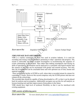
1. 1 | P a g e W h a t i s V D R ( V o y a g e D a t a R e c o r d e r ) ?
For more details please visit: www.captyashpal.blogspot.com
Microphone
Units
(Optional)
(Fixed or
Float-free Type)
(Main, Emergency and Reserve)
Simplified VDR diagram Captain Yashpal Singh
VDR (VOYAGE DATA RECORDER):
VDR is a marine counterpart of black box used in aviation industry. It is used for
recording and storing critical parameters pertaining to ship’s operation and progress. The
record is retrievable and helps accident investigators in reconstructing the sequence of
events culminating in the incident. Thus rather than making assumptions and relying on
skills of speculation, the situation can be analyzed in a systematic and logical manner and
the cause(s) of accident can be ascertained with greater and assured accuracy. Not only
that, the investigations can be concluded faster and with optimum use of time, human and
material resources.
There is recording facility in ECDIS as well, where data is recorded minute by minute for
a period of 12 hours. However this record comprises only the ECDIS picture and does not
contain all the critical data.
The recorded data should be capable of being downloaded to a PC so that it can be played
back for analysis and investigation. Additionally navigator can use this for self analysis, as
lessons-learning tool and thus improvement of procedures in the future.
VDR should have high level of technical flexibility so that it can be interfaced with
existing equipment.
VDR consists of following parts:
VDR
Main Unit
Input Data from
Radar, Echo
Sounder, Log,
Gyro, Wind
Meter, GPS etc.
Power
Supply
Voyage
Data
Capsule
Remote
Display
and
Replay
2. 2 | P a g e W h a t i s V D R ( V o y a g e D a t a R e c o r d e r ) ?
For more details please visit: www.captyashpal.blogspot.com
Power Supply Unit:
The VDR is supplied with electrical energy via this unit. In addition to the supply from
main source, VDR is also powered with emergency supply and also provided with reserve
power for specific task.
VDR Main Unit:
The unit receives the variety of data from different sensors via interface. It processes all
the data and stores them in compatible format. It is directly connected to power supply
unit.
Microphone Units:
It consists of microphone units strategically located to record voices and onboard
communications. The microphones placed in wheel/house, bridge wings, E/R and other
critical places.
VDR Capsule:
This may be fixed type or float-free type and is usually located in place free from
obstructions, such as Monkey Island. It is designed to meet stringent requirements of
withstanding shock, pressure tightness, easy detection, fire resistance, impact etc.
Alarm Unit:
This is part of the Main data Unit and warns the OOW of any malfunction and equipment
errors.
Replay Station (optional): This unit is not compulsory. Where fitted, it can be used to
download and replay the recorded data. This way the unit can be put to use for self-
analysis, meeting training needs and improving the operation practices and procedures.
Operation:
The VDR will continuously maintain a sequential record:
Of pre-selected data items related to ship status,
Output of the ship’s equipment and
Command and control of the ship.
The VDR shall record and store the following:
Status and Alarms:
Bridge alarms, Status of hull openings, water tight doors, fire doors, hull stresses and
accelerations.
Navigational equipment outputs:
Heading, ROT, speed, position, time, date, radar picture, echo sounder output and wind
direction/speed.
Command and Control: Rudder order/response, Engine order/response, onboard
communication, communication with other ships/stations.
VDR Capsule:
The voyage data capsule shall be entirely automatic and record data without human
intervention. It shall continuously record 12 hours of data from the VDR system. The
3. 3 | P a g e W h a t i s V D R ( V o y a g e D a t a R e c o r d e r ) ?
For more details please visit: www.captyashpal.blogspot.com
subsequent data will keep overwriting the previous data. The capsule will be installed in a
protective casing that is brightly coloured and fitted with an appropriate device to aid
location. Further:
It will be designed to allow copies of incident data to be made.
It may be fixed or float free capsule
It should be able to withstand impact equivalent to 250kg pin dropped from height
of 3m.
It should withstand fire at 260 degree Celsius for 10hrs
It should withstand pressure at depths of up to 6000m
It should be fitted with acoustic beacon
Fixed type or Float-free type:
The choice is left to the ship owner. Each type has its own advantages and requirements.
Fixed: Initial capital cost is more. The recovery is expensive and tedious. The
underwater beacon required to operate for 28 days following immersion. This gives time
for an accurate position fix to be obtained during a one month period. The decision or
necessity to recover the capsule can be postponed for up to two years post incident.
Float-free: Initial cost is less. The recovery is cheaper, faster and simpler. The beacon is
designed to operate for 7 days following release from the vessel. The capsule must be
located within this time frame, irrespective of priorities or sea conditions.
Advantages of VDR:
1. Accident investigation and enquiry is simpler, cheaper and faster.
2. Causal factors in an accident can be pinpointed with greater certainty.
3. It can be used for enhancing safety by addressing shortcomings becoming apparent
by self-analysis.
4. Eventually as the performance improves, claims and subsequently insurance
premium will come down.
5. Generation and study of data is easier, which will have multi-faceted use for the
industry.
Annual Performance Test:
VDR will be subjected to an annual performance test carried out by a suitably Competent
Person. The annual testing and checks must be carried in conjunction with the relevant
Statutory Survey (e.g. Passenger Ship Safety Certificate (PC), Cargo Ship Safety
Certificate (CSC) or Cargo Ship Safety Equipment Certificate (SEC)).The VDR check
must also be carried out within the survey period permitted by the Harmonized System of
Survey and Certification. The Survey Window allowed is up to 3 months before the due
date for PC; and -/+ 3 months of due date for CSC and SEC. (Thus the Maximum period
between subsequent checks of the VDR is 15 months for Passenger vessels and 18 months
for Cargo vessels).
4. 4 | P a g e W h a t i s V D R ( V o y a g e D a t a R e c o r d e r ) ?
For more details please visit: www.captyashpal.blogspot.com
Where vessels are on a partial continuous survey regime the VDR annual performance
testing can be scheduled into the continuous survey cycle.
The Competent Person shall check among other things, mainly: accuracy of data recorded,
duration for which data is recorded and recoverability of data recorded.
Data Ownership and Recovery:
Non-catastrophic accident:
In such cases the data recovery is obviously simple and straightforward. This simply
means an initiative in the direction of preserving the evidence soon after the accident, for
use by both the investigator and the ship owner. This usually will be carried out by ship
staff under the orders of Master, who in turn will be implementing the ship owners’
standing orders.
Abandon ship:
In the case of abandonment of a vessel during an emergency, master should exercise due
diligence, without compromising the safety of life, in recovering the stored data. The
master should further remove it to a place of safety and to preserve it until it can be passed
to the investigator.
Catastrophic accident:
In the case a vessel has sunk and the data has not been retrieved prior to abandonment, a
decision will need to be taken by the Flag State in consultation with any other
substantially interested states. The decision will depend on the viability of recovering the
protective capsule against the potential use of the information. If decision is to recover the
capsule, the investigator will be entrusted with responsibility. The assistance and co-
operation of the owners, insurers and the manufacturers of the VDR and those of the
protective capsule may be required. Expert assistance may also have to be hired to
maximize the recovery and preservation of the data.
Custody of VDR data:
The way investigators are allowed all access to bell books, log books, charts, course
recorders and other sources of evidence, the investigator, in all circumstances, during the
course of an investigation, should have custody of the original VDR data.
Although the investigator will have custody of the original VDR data, a copy of the data
must be provided to the ship owner in all circumstances.
Further access to the data will be governed by the applicable domestic legislation of the
flat state, coastal state and the lead investigating state as appropriate.
Ownership of VDR/data:
The ship owner will, in all circumstances and at all times, own the VDR and its data.
In all circumstances the responsibility to arrange down loading and read-out of the data
from the recovered memory in whatever form should, in the first instance, be undertaken
by the investigator who should keep the ship owner fully informed. Additionally,
especially in the case of a catastrophic accident where the memory may have sustained
5. 5 | P a g e W h a t i s V D R ( V o y a g e D a t a R e c o r d e r ) ?
For more details please visit: www.captyashpal.blogspot.com
damage, the assistance of specialist expertise may be required to ensure the best chance of
success.
VDR and S-VDR:
Both VDR and S-VDR are required to maintain sequential records of:
Pre-selected data
Output of ship’s equipment and
Command and control of ship.
However, specifications of VDR and S-VDR differ in two respects:
1. Number of sensors providing data are lesser in S-VDR
2. Requirements for the S-VDR protective capsule are different from that of VDR.
NOTE: The concept of S-VDR was introduced to take into account the difficulties being
encountered in interfacing the existing analog sensors on older ships.
VDR has already started doing its job helping judgments being delivered swiftly, justly
and without quibbling. Some examples are:
1. RO-RO ferry in collision with fishing vessel:
Radar information gained from the ferry’s VDR proved incontrovertibly that the fishing
vessel had made a large alteration of course across the ferry’s bow moments before the
collision, contrary to the Collision Regulations. Unfortunately bridge audio data which
might have given insight to the human factors that lay behind the accident was lost to the
investigators due to background noise from a radio which had been playing in the
wheelhouse for entertainment.
2. Vessel dragged anchor in high winds and touched another ship anchored to
leeward:
Evidence from the VDR allowed the Management to review action by the OOW and
provided the P&I club with the evidence they required to settle the claim
VDR has been a boon in helping ship owners and managers in identifying weak links,
shortcomings in their vessels’ onboard procedures and ship management. For example:
1. Near collision between passenger ferry and general cargo:
VDR information enabled the investigators to establish the true course of events which
was contrary to both the masters’ accounts. Shortfalls in bridge team management were
uncovered to the benefit of the individuals involved, the owners and training
establishments.
2. Passenger vessel lost power on a lee shore in gale force winds:
VDR information enabled a detailed analysis of the bridge team’s actions in an emergency
situation to be carried out. Many shortfalls in performance were uncovered to the benefit
of the bridge team, the owners and training establishments.
3. Vessel rounding Ushant was in close quarters situation whilst overtaking
another vessel:
6. 6 | P a g e W h a t i s V D R ( V o y a g e D a t a R e c o r d e r ) ?
For more details please visit: www.captyashpal.blogspot.com
Evidence from the VDR enabled management to review the OOW’s actions and take
necessary remedial action
Following example shows that ship owners’/ship managers’ initial reluctance to VDR was
not well-founded and though VDR is mandatory, it is a worthy investment:
1. Vessel berthing at builder's yard for guarantee dry docking hit jetty whilst
under pilotage sustaining $150,000 steel damage:
When the yard was made aware that Pilot’s actions had been recorded, they paid for
repairs without question.
Prior to VDR times it was not uncommon to attribute marine accidents to incompetence,
inexperience, misjudgments and poor seamanship of seafarers. Many officers have had
their careers ruined or borne the hard hand of the law. Officers indeed stand to benefit
more from fitting of VDR. Following examples should allay the fears of the officers who
dub VDR a spy-camera:
1. Vessel entering continental port was in collision with yacht:
Evidence from the VDR absolved the Master of all blame.
2. Vessel entering port in narrow channel struck an underwater object:
The VDR showed the ship to be right on track in the dredged channel, thus absolving the
Master from blame or criticism.
3. High speed close quarters incident with warship:
The VDR provided evidence that clearly confirmed that the HSC Master had taken the
correct action when the warship failed to give way as required by Collision regulations.
4. Engine room fire:
A review of the evidence from the VDR confirmed that in general terms, the personnel
concerned had taken the correct action, but some areas for improvement and training
needs were also identified.
(Source for examples of incidents/accidents: MAIB)