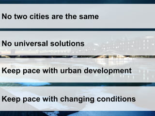
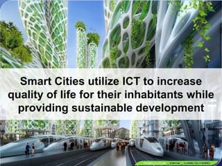
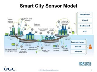
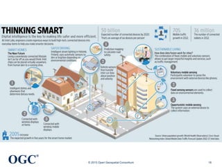
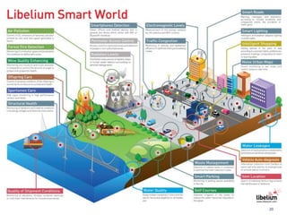
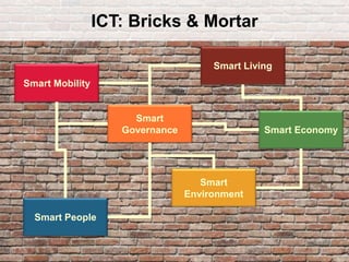
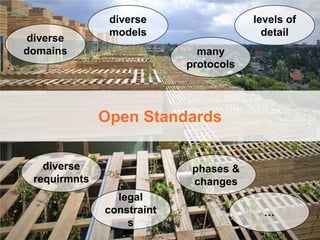
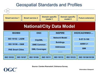
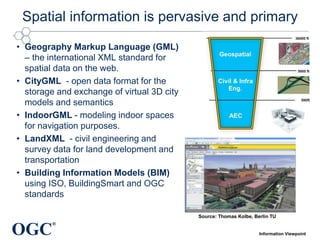
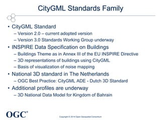
Smart Cities and the role of geospatial standards to optimize data exchange and service interoperability across data and service providers. Keynote given at AGIT 2015
Open Geospatial Consortium and Smart CitiesLuis Bermudez
The document summarizes the work of the Open Geospatial Consortium (OGC) in developing open standards for geospatial data and applications to support smart cities. It provides examples of OGC standards and pilots including the Web Feature Service, Sensor Observation Service, Sensor Things API, and CityGML. It introduces the OGC Smart Cities Spatial Information Framework for integrating geospatial data and applications across different city domains and layers. It also discusses social aspects of smart cities and how open data and technologies can promote public services, inclusion, and quality of life.
The presentation discusses the power of location data and services for mobile applications. It highlights opportunities for innovating mobile standards through the Open Geospatial Consortium's (OGC) standards and testbeds. These include standards for augmented reality, indoor navigation, sensor networks, and an urban Internet of Things testbed to enable interoperability across smart city initiatives.
The document discusses open data and its impacts. It notes that open data must be freely accessible, in reusable formats, and under an open license. Open data can impact politics, society, and the economy by enabling open innovation and business opportunities. Implementing an open data policy faces challenges regarding policy, regulation, capacity, and technology. The Open Data Charter provides principles for open data policies. OpenDataSoft is a company that helps make data scale and create value through visualizations, APIs, and enabling data reuse. It discusses using open data in areas like transportation, smart cities, and performance management.
Dati satellitari e prodotti derivati in modalità open and free del programma ...giovannibiallo
Dati satellitari e prodotti derivati in modalità open and free del programma Copernicus - Marcello Maranesi (e-GEOS) - Conferenza OpenGeoData Italia 2015
This presentation accompanied a joint keynote address given by AAM's Brian Nicholls and Singapore Land Authority's (SLA) Dr Victor Khoo at the Locate17 Conference. AAM and the SLA are working together to capture and deliver an accurate and up-to-date 3D digital map for the entire country of Singapore, providing the digital framework for Singapore's visionary Smart Nation program. This presentation outlines the processes and technologies used to create the 3D digital map and highlights the many applications stemming from it such as Property Management systems, Solar Potential Studies, the development of Driverless Vehicle systems and more (many yet to be discovered!).
A tecnologia está cada vez mais presente no dia a dia das pessoas e tem provocado uma corrida nas empresas pela modernização de aplicações. Durante essa palestra sobre com o tema “O futuro do software” realizada pelo Ramon Durães que é CEO na DevPrime e Microsoft MVP é discutido insgiths importantes sobre o atual momento do mercado e a importância de se adequar o desenvolvimento de aplicações para essa nova dinâmica do mercado.
Algumas iniciativas como o desenvolvimento de microservices se tornarem estratégicas nesse novo cenário de cloud-native application development.
This document discusses using GIS modeling for smart safe city applications such as crime investigation, prevention, and traffic planning. It describes how GIS can be used for crime mapping and analysis to identify crime hotspots, predict influencing areas, and statistically analyze crime data. Technologies like GPS, cameras, and lidar scanning can be integrated into a smart snake tracking system for surveillance. GIS modeling aggregates data from multiple sources to provide investigative leads and forecast future crime locations to support operational planning and resource deployment decisions. The key functions of GIS like spatial queries, analysis, and visualization help critical decision making for public safety agencies.
Big Data in Real Estate - Digital Real Estate SummitRaphael Rollier
Raphael Rollier spoke at the Digital Real Estate Summit on February 7th 2017 about new ways of working using data and technology, such as using augmented reality maps for construction logistics optimization and transit bundling. He discussed how this could enable new services like population monitoring and prevention to address aging. Finally, he noted that verticals will become ecosystems by leveraging data to match needs, and that technology, business cases, politics, regulation, governance, skills, and soft factors are keys to success in enabling new services and ways of working through data and ecosystem creation.
Presentation provided at "Geo Gebruikersfestival", okt 31, 2018, Amersfoort, The Netherlands. Sketches how from several Sensor projects the Smart Emission Platform emerged and migrated to the PDOK Platform. How a next step could be be a Dutch national Sensor SDI asa a federated/distributed architecture. Special attention is given to APIs, in particular the SensorThings API.
Agi foresight presentation data and technology 20100714Andy Coote
The document provides a vision for the geospatial industry in 2015, predicting several major paradigm shifts driven by increasing pace of change, globalization, and new technologies. Key predictions include: ubiquitous positioning through smartphones and sensors; open source geospatial software becoming standard; cloud computing as the dominant delivery mechanism; mainstream consumer location-based services; augmented reality; crowd-sourced mapping through OpenStreetMap; 3D point cloud data from lidar; and the semantic web allowing natural language queries. The geospatial industry will need to adapt business models, engage with app developers, help users through changes, and improve communications with non-expert users.
Asset tracking refers to tracking the method of physical assets, either by scanning barcode labels attached to the assets or by using tags using GPS or RFID which broadcast their location. (Definition from wiki)
FIWARE Tech Summit - URBO - Map-based City Operational Dashboards BasedFIWARE
Urbo is an operational dashboard developed by Geographica for cities and public administrations that analyzes real-time data from various sensors to provide insights about parking, waste management, lighting, transportation and other systems. It aims to improve citizens' quality of life by optimizing resource usage and promoting accurate, agile decision making while also preventing unwanted events through predictive analytics. The dashboard utilizes specialized PostgreSQL functions and a module for processing tasks to perform advanced spatial operations and analyses.
This presentation discusses the development of smart cities using big sensor data through collaborative efforts. It describes how sensor data from sources like geo-sensors, mobile devices, and social media can be used to understand human activities and urban dynamics. A smart system is needed to integrate this big sensor data, perform processing and mining, and act as a platform for applications. This will help support decisions by residents, visitors and governments. The presentation then discusses a research project that is developing a middleware architecture for spatio-temporal processing of sensor data. It provides an example of Santander, Spain, which extensively uses sensors. The goal of the collaborative smart city approach is to promote data integration and development of smart environments that benefit citizens.
Presentation given at European Conference on Artificial Intelligence in Montpellier, FR for the workshop I co-chaired on Intelligent Agents in Urban Simulations and Smart Cities.
Videos will not work...
A smart city is an urban development vision to integrate multiple information and communication technology (ICT) solutions in a secure fashion to manage a city’s assets – the city’s assets include, but not limited to, local departments information systems, schools, libraries, transportation systems, hospitals, power plants, water supply networks, waste management, law enforcement, and other community services.(Definition from WIKI)
As an industry we need to do a better job of making sense of our dynamically changing world by combining sensors, with software focused on providing solutions that work together to solve the challenges we meet today.
SensiNact is a co-creation tool that allows experimenters to access IoT devices deployed in cities and understand their data streams. The SensiNact IDE uses a scripting tool to create applications that can aggregate data from multiple devices to create virtual devices or set alerts when data reaches certain thresholds. SensiNact provides application design, execution, data collection and storage as a cloud-based service or locally instantiated instance.
Keynote presentation by Dr. Fatih Gundogan, Deputy General Manager of ISBAK-Istanbul, at the Selangor Smart City & Future Commerce Convention 2017, on the topic titled 'Istanbul’s Big Smart Roadmap'
The Metamorphoses of Smart Cities - of Barcelona and Selangorsitecmy
Opening Keynote Speech by Joan-Anton Sanchez, Research and Content Director of Mediaurban, Barcelona, presented at the Selangor Smart City & Future Commerce Convention 2017, at Setia City Convention Centre, Shah Alam on 7 September 2017
Slides from Pekka Koponen, Development Director, Forum Virium Helsinki; CitySDK. Presented at CSC 2016, session 1: OASC 101 – getting hands-on with API, data models
The document discusses plans to develop the Kalasatama district of Helsinki into an "Agile Smart City Living Lab". Key points:
- Kalasatama will be developed over the next 20 years to house 20,000 new residents and 8,000 new jobs.
- It aims to serve as an "Agile Smart City" through pilot projects testing new technologies and services for residents with a focus on energy, transport, education and healthcare.
- The first pilot areas include residential and commercial developments between 2011-2021 that will house over 4,000 residents and students.
- Funding support is provided through various government programs to encourage private companies and public bodies to test innovations in Kalasat
Smart City and Innovation in Hong Kong - Priorities and ChallengesCharles Mok
Charles Mok discusses smart city development in Hong Kong and priorities and challenges. He outlines a framework with components like economy, mobility/transport, environment, living, and governance. International examples from cities like Barcelona and Seoul show initiatives in areas like free public Wi-Fi, environmental monitoring, and emergency response systems. Upcoming government consultations will explore creating a smart city blueprint. Key to development will be talent, funding, infrastructure, partnerships between government and businesses, and an innovation-friendly culture. Hong Kong has opportunities in areas like transportation, green initiatives, finance, and data centers.
This document introduces WeLive, a new concept for public administration based on citizen co-created mobile urban services. WeLive aims to transform current e-government approaches into a collaborative solution using web, technology, information, and mobility. It proposes an open ecosystem of tools to promote co-innovation and co-creation of personalized public services through public-private partnerships. WeLive will undergo two-phase pilots in four cities/regions across Europe to test exploitable public service applications and other assets.
The document discusses Auroville, India as a case study for smart city development. It outlines Auroville's vision and master plan, which focuses on regenerating the local ecosystem, urban farming for resilience, and using information systems for monitoring progress. It also details Auroville's approaches to energy, water, waste and transportation management which emphasize sustainability through solutions like solar power, rainwater harvesting, waste segregation, and electric vehicles. The document concludes by noting Auroville's role in advising policymakers and developing voluntary guidelines to support green development.
Here is an example:
- Total cost of the project is €150,000
- SME applies individually and is eligible for 80% funding
- 80% of €150,000 is €120,000
- However, the individual cap is €100,000
- Therefore, the SME will receive a grant of €100,000
- The remaining 20% (€30,000) must be provided by the SME either as in-kind or own funding
CASE 2 – Pilot Group of 3 applies
Principle:
i. Fund is 80% of the total cost of the project, with an overall cap of € 300,000
ii. Each member of the pilot group will need
Virtualisation taking place – Martin BrynskovMartin Brynskov
How understanding virtualisation, the computing continuum and communities of practice is essential for making the right investments in research, innovation and deployment. A global perspective from Europe. By Martin Brynskov https://www.linkedin.com/in/brynskov/
Martin Brynskov is the chair of Open & Agile Smart Cities (OASC) and coordinator of SynchroniCity and NGIoT initiatives. The summary is:
OASC's mission is to create a global smart city market based on city needs through a global network of 130 cities in 28 countries. SynchroniCity provides a common technical ground including OASC standards, reference implementations, and cloud hosting to enable innovation and procurement of IoT services across domains. The SynchroniCity architecture defines interoperability points for key APIs to integrate city data and applications.
OECD Roundtable on Smart Cities and Inclusive GrowthOECDregions
Cities around the world are still battling COVID-19 and shaping their way out of the crisis.
As the world learns to live with the virus, never have digital technologies and innovation been so valuable to help cities navigate the crisis and accelerate the transition towards a more sustainable and resilient future. Both before and during the pandemic, smart city initiatives have flourished around the globe, together with various attempts to develop smart city indices and indicators.
With substantial public funding channelled into smart recovery efforts, it is more critical than ever to assess whether investment in smart cities improves people’s lives. To what extent do smart cities deliver concrete well-being outcomes for all? How can such outcomes be effectively measured, monitored and maximised?
Learn more from our Roundtable: oe.cd/sc-rt
Smart City concept overview with many references from around the world through the eyes of an Enterprise Architect and Urban Technologist. It is also an attempt to assess BSI SCF value proposition and success factors for its implementation. The approach draws also on the work done by The Open Group and other standardization bodies supporting Smart City approach.
Professor Isam Shahrour Summer Course « Smart and Sustainable City » Chapter...Isam Shahrour
This lecture presents the Smart City Concept. It includes presentation of the city challenges, the response of the Smart City to these challenges, the Smart City concept, a survey of the smart city development in the world and the methodology of the implementation of this concept.
BCG's Holger Rubel describes how urbanization is changing the world and explores how five sectors in "smart cities" are evolving: energy, transport, water and waste, social initiatives, and buildings.
OGC SensorThings API - a very short introduction for ITU-TSensorUp
This is the presentation for United Nation's ITU-T Forum on Smart Cities Data Management. From a connected babies perspective, it showed the pain of existing IoT system, which is not interoperable and difficult to integrate them into one coherent system. Then we demonstrated several examples of OGC SensorThings API, including smart shirts, drones, and air quality monitoring.
ETSI is working on several standards related to smart cities through various groups. These groups are developing standards for technologies like wireless connectivity, security, energy efficiency, and data management that are applicable to smart city initiatives. ETSI is also collaborating with external groups to further standardization efforts and help cities understand and apply relevant standards. The presentation provided an overview of ETSI's smart city-related groups and standards work.
Big data and smart cities are closely related. Smart cities use big data and data analytics to optimize resource management, address issues like population growth and global warming, and manage tight budgets. Some examples of smart city projects utilizing big data include using sensors to manage intermittent bus lanes, powering electric buses through electric roads, and building green data centers to reduce energy usage. While mega smart cities promise advanced technology and services, they also face challenges of large budgets, construction delays, and defining success. Overall, big data and smart technologies have potential to improve city operations when applied strategically to address specific issues.
The Business Case for Smart Cities
• What is a Smart City?
• Where are the Smart Cities?
• Does Smart = Sustainable?
• How can the investment be justified?
• How can success be measured?
The document summarizes India's Smart Cities Mission. It states that 99 cities across India have been selected to be upgraded as smart cities. The top three cities selected in the first round were Bhubaneswar, Pune, and Jaipur. It provides an overview of key smart city features like smart IT, transportation, energy, and environmental management solutions. It also briefly discusses the global smart city landscape and top-ranked cities worldwide. In closing, it lists the cities selected in each round of the Smart Cities Mission.
The document discusses how the Open Geospatial Consortium (OGC) is working to support the Internet of Things (IoT). It provides examples of OGC pilot projects that use geospatial standards to enable interoperability between IoT devices and sensors for applications in cities, construction, and emergency response. The document advocates for open standards to allow different IoT systems and devices to communicate and share data more effectively.
Session 1.3 context information management across smart city knowledge domainssemanticsconference
This document provides an introduction to the ETSI Industry Specification Group on Context Information Management (ISG CIM). It discusses the goals of ISG CIM, which are to develop technical specifications for exchanging contextual information across different domains. It outlines the scope and status of ongoing work items, including use cases, architecture and gap analysis, an API specification, information models, and security considerations. Examples of contextual information exchange across different smart city domains are also discussed.
The document discusses the Open Geospatial Consortium (OGC), an international standards organization for geospatial data and location-based services. It provides examples of OGC standards being used for 3D city models, indoor mapping, utilities/energy, and transportation data. The OGC works with other standards bodies and promotes the use of standards to enable sharing of geospatial data and applications in areas like smart cities, maritime, agriculture, and more.
OSGi for European and Japanese smart cities - experiences and lessons learnt ...mfrancis
OSGi Community Event 2016 Presentation by Levent Gurgen (CEA)
Internet of Things (IoT) is the digital skin of the physical world. It has specific requirements such as dynamicity to self-adapt to the continuously changing physical context. The world is heterogeneous and the objects should interoperate to collaborate, thus interoperability is essential. Openness and short learning curve are other requirements so that innovators (e.g. startups) can rapidly build applications with reduced time-to-market and avoid vendor lock-in. Reuse of software and hardware is also particularly important since billion of devices are expected to be deployed in the coming decades and those devices should be multi-purpose and reusable by applications from different domains and not be specific to a given domain.
OSGi has – since 15 years ago – the answers to those requirements of today’s IoT. Its powerful run-time environment for the dynamicity, its service-oriented approach hiding heterogeneity, its modularity making the reuse extremely simple, and last but not least, its open approach giving the potential to democratize the IoT.
The talk will illustrate the benefits of OSGi for IoT with concrete deployed examples, in particular in smart city domain in Europe and Japan via the collaborative projects such as ClouT and FESTIVAL.
Chapter 3 introduction to the smart city concept, AUST 2015Isam Shahrour
This lecture presents the concept of the smart city with particular focus on the use of the digital technology and collective governance. It also presents the data collection, analysis and use in the management of the City and the methodology to be followed for the implementation of the Smart City concept.
Business intelligence on the US greentech marketEC2i
EC2i objective is to support the internationalisation of European Cleantech SMEs in China and the United States by conducting cluster missions and facilitating cross-cluster partnerships. In this sense, attention is paid to developing tools to guide SMEs through the process of forming consortia and developing projects with clients.
Business intelligence for relevant US and Chinese markets have been collected in reports and are here disseminated to SMEs.
The tools presented here address general barrieres to internationalisation as well as more specific problems SMEs face when integrating themselves into complex, international value chains.
Similar to Open standards: A success factor for smart cities (20)
TrustArc Webinar - 2024 Global Privacy SurveyTrustArc
How does your privacy program stack up against your peers? What challenges are privacy teams tackling and prioritizing in 2024?
In the fifth annual Global Privacy Benchmarks Survey, we asked over 1,800 global privacy professionals and business executives to share their perspectives on the current state of privacy inside and outside of their organizations. This year’s report focused on emerging areas of importance for privacy and compliance professionals, including considerations and implications of Artificial Intelligence (AI) technologies, building brand trust, and different approaches for achieving higher privacy competence scores.
See how organizational priorities and strategic approaches to data security and privacy are evolving around the globe.
This webinar will review:
- The top 10 privacy insights from the fifth annual Global Privacy Benchmarks Survey
- The top challenges for privacy leaders, practitioners, and organizations in 2024
- Key themes to consider in developing and maintaining your privacy program
Monitoring and Managing Anomaly Detection on OpenShift.pdfTosin Akinosho
Monitoring and Managing Anomaly Detection on OpenShift
Overview
Dive into the world of anomaly detection on edge devices with our comprehensive hands-on tutorial. This SlideShare presentation will guide you through the entire process, from data collection and model training to edge deployment and real-time monitoring. Perfect for those looking to implement robust anomaly detection systems on resource-constrained IoT/edge devices.
Key Topics Covered
1. Introduction to Anomaly Detection
- Understand the fundamentals of anomaly detection and its importance in identifying unusual behavior or failures in systems.
2. Understanding Edge (IoT)
- Learn about edge computing and IoT, and how they enable real-time data processing and decision-making at the source.
3. What is ArgoCD?
- Discover ArgoCD, a declarative, GitOps continuous delivery tool for Kubernetes, and its role in deploying applications on edge devices.
4. Deployment Using ArgoCD for Edge Devices
- Step-by-step guide on deploying anomaly detection models on edge devices using ArgoCD.
5. Introduction to Apache Kafka and S3
- Explore Apache Kafka for real-time data streaming and Amazon S3 for scalable storage solutions.
6. Viewing Kafka Messages in the Data Lake
- Learn how to view and analyze Kafka messages stored in a data lake for better insights.
7. What is Prometheus?
- Get to know Prometheus, an open-source monitoring and alerting toolkit, and its application in monitoring edge devices.
8. Monitoring Application Metrics with Prometheus
- Detailed instructions on setting up Prometheus to monitor the performance and health of your anomaly detection system.
9. What is Camel K?
- Introduction to Camel K, a lightweight integration framework built on Apache Camel, designed for Kubernetes.
10. Configuring Camel K Integrations for Data Pipelines
- Learn how to configure Camel K for seamless data pipeline integrations in your anomaly detection workflow.
11. What is a Jupyter Notebook?
- Overview of Jupyter Notebooks, an open-source web application for creating and sharing documents with live code, equations, visualizations, and narrative text.
12. Jupyter Notebooks with Code Examples
- Hands-on examples and code snippets in Jupyter Notebooks to help you implement and test anomaly detection models.
Digital Marketing Trends in 2024 | Guide for Staying AheadWask
https://www.wask.co/ebooks/digital-marketing-trends-in-2024
Feeling lost in the digital marketing whirlwind of 2024? Technology is changing, consumer habits are evolving, and staying ahead of the curve feels like a never-ending pursuit. This e-book is your compass. Dive into actionable insights to handle the complexities of modern marketing. From hyper-personalization to the power of user-generated content, learn how to build long-term relationships with your audience and unlock the secrets to success in the ever-shifting digital landscape.
A Comprehensive Guide to DeFi Development Services in 2024Intelisync
DeFi represents a paradigm shift in the financial industry. Instead of relying on traditional, centralized institutions like banks, DeFi leverages blockchain technology to create a decentralized network of financial services. This means that financial transactions can occur directly between parties, without intermediaries, using smart contracts on platforms like Ethereum.
In 2024, we are witnessing an explosion of new DeFi projects and protocols, each pushing the boundaries of what’s possible in finance.
In summary, DeFi in 2024 is not just a trend; it’s a revolution that democratizes finance, enhances security and transparency, and fosters continuous innovation. As we proceed through this presentation, we'll explore the various components and services of DeFi in detail, shedding light on how they are transforming the financial landscape.
At Intelisync, we specialize in providing comprehensive DeFi development services tailored to meet the unique needs of our clients. From smart contract development to dApp creation and security audits, we ensure that your DeFi project is built with innovation, security, and scalability in mind. Trust Intelisync to guide you through the intricate landscape of decentralized finance and unlock the full potential of blockchain technology.
Ready to take your DeFi project to the next level? Partner with Intelisync for expert DeFi development services today!
Salesforce Integration for Bonterra Impact Management (fka Social Solutions A...Jeffrey Haguewood
Sidekick Solutions uses Bonterra Impact Management (fka Social Solutions Apricot) and automation solutions to integrate data for business workflows.
We believe integration and automation are essential to user experience and the promise of efficient work through technology. Automation is the critical ingredient to realizing that full vision. We develop integration products and services for Bonterra Case Management software to support the deployment of automations for a variety of use cases.
This video focuses on integration of Salesforce with Bonterra Impact Management.
Interested in deploying an integration with Salesforce for Bonterra Impact Management? Contact us at sales@sidekicksolutionsllc.com to discuss next steps.
Generating privacy-protected synthetic data using Secludy and MilvusZilliz
During this demo, the founders of Secludy will demonstrate how their system utilizes Milvus to store and manipulate embeddings for generating privacy-protected synthetic data. Their approach not only maintains the confidentiality of the original data but also enhances the utility and scalability of LLMs under privacy constraints. Attendees, including machine learning engineers, data scientists, and data managers, will witness first-hand how Secludy's integration with Milvus empowers organizations to harness the power of LLMs securely and efficiently.
Your One-Stop Shop for Python Success: Top 10 US Python Development Providersakankshawande
Simplify your search for a reliable Python development partner! This list presents the top 10 trusted US providers offering comprehensive Python development services, ensuring your project's success from conception to completion.
Skybuffer SAM4U tool for SAP license adoptionTatiana Kojar
Manage and optimize your license adoption and consumption with SAM4U, an SAP free customer software asset management tool.
SAM4U, an SAP complimentary software asset management tool for customers, delivers a detailed and well-structured overview of license inventory and usage with a user-friendly interface. We offer a hosted, cost-effective, and performance-optimized SAM4U setup in the Skybuffer Cloud environment. You retain ownership of the system and data, while we manage the ABAP 7.58 infrastructure, ensuring fixed Total Cost of Ownership (TCO) and exceptional services through the SAP Fiori interface.
Main news related to the CCS TSI 2023 (2023/1695)Jakub Marek
An English 🇬🇧 translation of a presentation to the speech I gave about the main changes brought by CCS TSI 2023 at the biggest Czech conference on Communications and signalling systems on Railways, which was held in Clarion Hotel Olomouc from 7th to 9th November 2023 (konferenceszt.cz). Attended by around 500 participants and 200 on-line followers.
The original Czech 🇨🇿 version of the presentation can be found here: https://www.slideshare.net/slideshow/hlavni-novinky-souvisejici-s-ccs-tsi-2023-2023-1695/269688092 .
The videorecording (in Czech) from the presentation is available here: https://youtu.be/WzjJWm4IyPk?si=SImb06tuXGb30BEH .
Fueling AI with Great Data with Airbyte WebinarZilliz
This talk will focus on how to collect data from a variety of sources, leveraging this data for RAG and other GenAI use cases, and finally charting your course to productionalization.
Taking AI to the Next Level in Manufacturing.pdfssuserfac0301
Read Taking AI to the Next Level in Manufacturing to gain insights on AI adoption in the manufacturing industry, such as:
1. How quickly AI is being implemented in manufacturing.
2. Which barriers stand in the way of AI adoption.
3. How data quality and governance form the backbone of AI.
4. Organizational processes and structures that may inhibit effective AI adoption.
6. Ideas and approaches to help build your organization's AI strategy.
Let's Integrate MuleSoft RPA, COMPOSER, APM with AWS IDP along with Slackshyamraj55
Discover the seamless integration of RPA (Robotic Process Automation), COMPOSER, and APM with AWS IDP enhanced with Slack notifications. Explore how these technologies converge to streamline workflows, optimize performance, and ensure secure access, all while leveraging the power of AWS IDP and real-time communication via Slack notifications.
Dive into the realm of operating systems (OS) with Pravash Chandra Das, a seasoned Digital Forensic Analyst, as your guide. 🚀 This comprehensive presentation illuminates the core concepts, types, and evolution of OS, essential for understanding modern computing landscapes.
Beginning with the foundational definition, Das clarifies the pivotal role of OS as system software orchestrating hardware resources, software applications, and user interactions. Through succinct descriptions, he delineates the diverse types of OS, from single-user, single-task environments like early MS-DOS iterations, to multi-user, multi-tasking systems exemplified by modern Linux distributions.
Crucial components like the kernel and shell are dissected, highlighting their indispensable functions in resource management and user interface interaction. Das elucidates how the kernel acts as the central nervous system, orchestrating process scheduling, memory allocation, and device management. Meanwhile, the shell serves as the gateway for user commands, bridging the gap between human input and machine execution. 💻
The narrative then shifts to a captivating exploration of prominent desktop OSs, Windows, macOS, and Linux. Windows, with its globally ubiquitous presence and user-friendly interface, emerges as a cornerstone in personal computing history. macOS, lauded for its sleek design and seamless integration with Apple's ecosystem, stands as a beacon of stability and creativity. Linux, an open-source marvel, offers unparalleled flexibility and security, revolutionizing the computing landscape. 🖥️
Moving to the realm of mobile devices, Das unravels the dominance of Android and iOS. Android's open-source ethos fosters a vibrant ecosystem of customization and innovation, while iOS boasts a seamless user experience and robust security infrastructure. Meanwhile, discontinued platforms like Symbian and Palm OS evoke nostalgia for their pioneering roles in the smartphone revolution.
The journey concludes with a reflection on the ever-evolving landscape of OS, underscored by the emergence of real-time operating systems (RTOS) and the persistent quest for innovation and efficiency. As technology continues to shape our world, understanding the foundations and evolution of operating systems remains paramount. Join Pravash Chandra Das on this illuminating journey through the heart of computing. 🌟
Trusted Execution Environment for Decentralized Process MiningLucaBarbaro3
Presentation of the paper "Trusted Execution Environment for Decentralized Process Mining" given during the CAiSE 2024 Conference in Cyprus on June 7, 2024.
4. OGC
®
4
Today, 70% of global energy is consumed in cities
Today, 60-80% of GDP is generated in big cities
By 2050, 70% of the world’s population will live in cities
23. OGC
®
Spatial Smart City Enterprise Components
Based on ITU Focus Group on Smart Sustainable Cities
City Sensor Webs
Sensor networks
Crowdsourcing
Phones, Wearables
Sensing
Layer
Analytics
and Models Metadata
Catalogs,
Semantics
Business
Layer
Visualization and
Decision Support
Population
Data
Data Access
Geospatial
Data
Data
Layer
Data Ingest and Quality Checking
Other
Data
Enterprise
Data
Urban/Municipal Database
Economic
Data
Health
Application
Layer
Intelligent buildings Intelligent transportation Open data
Environmental ProtectionPublic safety and security Urban planning
UtilitiesEmergency Services EducationSanitation
Elected Officials PublicMunicipal Employees
Cloudhostedresources
SecuritySystem
Smart City Information Enterprise
30. OGC
®
Benefits: German DIN Study
• Standards promote worldwide trade,
encouraging rationalization, quality assurance
and environmental protection, as well as
improving security and communication.
• Standards have a greater effect on economic
growth than patents or licenses.
• Standards facilitate procurement
• Standards create “Markets”
• "Economic Benefits of Standardization"
• Benefits to German economy of 17 billion Euros in
2010!
(c) 2015 Open Geospatial Consortium
31. OGC
®
Benefits: NIST (USA)
• “…the annual cost of waste
due to inadequate
interoperability among
computer-aided design,
engineering, and software
systems in the construction
industry to be $15.8
billion...”
•
39. OGC
®
Geospatial Standards and Profiles
ISO/BSI
ISO 19103 ISO 19107 ISO 19108 ISO 19111 ISO 19115 ISO 19123 ISO 19136/19139
ISO 19152 - LADM
ISO 19156 – O&M
PAS Smart Cities
OGC IHO/ICAO/WMO/....INSPIRE
National/City Data Model
Smart service 1 Smart service 2
Domain specific
model 1
Domain specific
model 2
S-57/ S-100
AIXM 5.1
Network Model
Buildings
Addresses
........
CityGML
SWE Common
BIM
Future extension
GML Coverages
Information Viewpoint
Source: Carsten Roensdorf, Ordnance Survey
40. OGC
®
Spatial information is pervasive and primary
• Geography Markup Language (GML)
– the international XML standard for
spatial data on the web.
• CityGML - open data format for the
storage and exchange of virtual 3D city
models and semantics
• IndoorGML - modeling indoor spaces
for navigation purposes.
• LandXML - civil engineering and
survey data for land development and
transportation
• Building Information Models (BIM)
using ISO, BuildingSmart and OGC
standards
Source: Thomas Kolbe, Berlin TU
Information Viewpoint