SlideShare a Scribd company logo
1 of 4
Download to read offline
International Research Journal of Engineering and Technology (IRJET) e-ISSN: 2395-0056
Volume: 09 Issue: 03 | Mar 2022 www.irjet.net p-ISSN: 2395-0072
© 2022, IRJET | Impact Factor value: 7.529 | ISO 9001:2008 Certified Journal | Page 142
Chilli Crop Acreage Estimation with Sentinel-2 Temporal Satellite
Imagery in Nagpur District, Maharashtra
Poonam Jayhind Pardeshi1, Dr. Indal Ramteke2, Dr. Sudhakar Shukla3
1M.Tech Scholar, School of Geo-informatics, Remote Sensing Applications Centre, Uttar Pradesh, India
2Scientific Associate, Agriculture Resource Division, Maharashtra Remote Sensing Applications Centre,
Maharashtra, India
3Scientist-SE and Head of School of Geo-informatics, Remote Sensing Applications Centre, Uttar Pradesh, India
---------------------------------------------------------------------***----------------------------------------------------------------------
Abstract - Optical Remote Sensing technology made it easier
to separate multiple crop types of the specific area. Studyarea
with multiple crops and having the same sowing and
harvesting time is difficult to classify using single date data.
But multiple crops can be easily separable using time-series
optical data. Hence, for thepresentstudytime-series, temporal
satellite data is used for crop mapping and crop acreage
estimation. Sentinel-2 B is the most used optical satellite data
for vegetation mapping. It provides high-resolution free
satellite data with spatial resolution of 10m and five days
revisit time in various applications of agriculture study. This
study aims to separate and acreage estimation of chilli crops
in Nagpur district using multi-date Sentinel-2 imagery for
Rabi season. Unsupervised classification method is adoptedto
separate chilli and verified with ground truth data.
Key Words: chilli; crop; classification; time-series;
separation; k-means; sentinel-2; unsupervised
1. INTRODUCTION
Agriculture is the largest sector available for livelihood in
India. Most of the population of the country is based on
agriculture and its allied sectors; the sector is occupied by
both small and marginal farmers.Agricultureisanimportant
sector of the Indian economy as it contributes about 17% to
the total GDP and provides employment to around 58% of
the population. Indian agriculture has registeredimpressive
growth over the last few decades. India is the biggest
exporter of Cotton in the world which is mostly grownin the
Maharashtra region.
Multispectral Sentinel-2 satellite data with Blue, Green, Red
and Near-Infrared bands having spatial resolution of 10m
are used for accurate crop mapping. It also gives Coastal
Aerosol, Water Vapour and SWIR-Cirrus band with 60m
resolution, four Vegetation Red Edge bands with different
wavelengths and having spatial resolution 20m and two
different SWIR bands with spatial resolution of 20m. Optical
remote sensing is used in various applications of agriculture
such as biomass estimation, drought monitoring, crop
condition monitoring, precision agriculture, crop yield
mapping etc.
Here, Time series sentinel data of Rabi season is taken for
analysis of the study area. To perform unsupervised
classification with good accuracy, classificationprocedureis
carried out with ground truth points.
2. STUDY AREA
Fig-1 : Location Map of Nagpur District, Maharashtra
Maharashtra is the third largest stateinarea andthesecond-
largest state in the population of India. Having an area of
307,713 sq. km with 35 districts, 358 blocks and 43711
villages and a population of 112,372,972 with 45%
population of the state is urban. Nagpur is the winter capital
city of Maharashtra state which is located in north eastern
part of the state. The landscape in and around Nagpur
consist of low flat-topped hills, black and fertile soils in the
valleys of streams and rivers. The City is located at 20 35‟ to
21 45‟ North Latitude and 78 15‟ to 79 40‟ East Longitude.
Altitude at 274m minimum and 652m maximum, location of
the city is actually geographical center of the India. Kanhan
River plays important role in the lives of the district. The
Agriculture of Nagpur is primarily based on rain and canals
which increases district production and productivity. In
Nagpur district mainly Chilly and Oranges gives better
returns as compared to other crops. In south eastern part of
the district, Chilly crops are mainly taken.Asthechillyisalso
famous by the name Bhiwapuri Mirchi. For crop separation
International Research Journal of Engineering and Technology (IRJET) e-ISSN: 2395-0056
Volume: 09 Issue: 03 | Mar 2022 www.irjet.net p-ISSN: 2395-0072
© 2022, IRJET | Impact Factor value: 7.529 | ISO 9001:2008 Certified Journal | Page 143
and acreage estimation of the district, data is acquired from
the USGS Earth Explorer.
3. DATA AND SOFTWARE USED
Data used: Sentinel-2b, Shape files of Nagpur district,
Ground truth data
Software: ArcGIS, Erdas Imagine, Google Earth Pro
4. METHODOLOGY
Classification of different crops using remote sensing
technology primarilydependsonthegrowingstagesofcrops
and on crop season. Nagpur district takes multiple crops in
Rabi season which includes gram, wheat, jowar, maize
including chilli etc. For the classification of multiple crops,
we used time-series data. There are two different
classification techniques namely Supervised and
Unsupervised classification. Supervised classification refers
to the classification which uses trainingsamplescollected by
the user in which software uses training pixels as references
for classifying all other pixels of an image. Where the
unsupervised classification uses software algorithms for
classification of an image without any human intervention.
Different temporal images of the Rabi season were
downloaded for the month October, November, December
and January of the year 2021 & 2022. Selected data were
used for analysis with less than 20% of cloud cover. False
colour composite images were obtained from band-2(Blue),
band-3(Green), band-4(Red) & band-8(Visible and Near
Infrared). Near-infrared (B8) band is good at reflecting
chlorophyll which shows healthy vegetation in bright red.
Raster layer of agriculture mask and Orchard mask layerare
applied on stacked NDVI image of agriculture fields for
masking out only agricultural area for classification. NDVI
images of different dates are layer stacked together in order
to obtain NDVI profile of crops.
The Present study uses an unsupervised classification
technique with the K-means clustering method. 50 classes
were used with 0.999 convergence threshold for image
processing. Where k-means is an algorithm that partitions
‘n” observations into ‘k’ clusters in which each observation
belongs to the cluster with the nearest centroid. The images
are classified into clusters having similarpixelsvalues.Mean
NDVI reflectance value is calculated each class. For NDVI
profile generation of each crop and for crop identification,
NDVI versus different month graph is created for each class.
Based on the NDVI reflectance values of crops and their
varying curve within the course of crop growth, different
crops were identified.
Chart-1: Graphical representation of identified Chilli
crops (Rabi Season: 2021-2022)
Major crops taken in Rabi season areGramand Wheat which
are taken abundantly. Some chilli fields are also taken in the
district. Chilli crops are standing crops of Rabi season which
can be easily interpreted based on their NDVI profile.
Fig-2: Classified Map of Nagpur District for Chilli crop
(Rabi Season: 2021-2022)
Fig-3: Ground Truth points of Nagpur District for Chilli
crop (Rabi Season: 2021-2022)
International Research Journal of Engineering and Technology (IRJET) e-ISSN: 2395-0056
Volume: 09 Issue: 03 | Mar 2022 www.irjet.net p-ISSN: 2395-0072
© 2022, IRJET | Impact Factor value: 7.529 | ISO 9001:2008 Certified Journal | Page 144
5. RESULTS
The estimated Chilli acreage is based on NDVI reflectance
values obtained from sentinel-2 satellites. All chilli fieldsare
identified as standing crop in Rabi season for the study area
whose NDVI profile graph is increasing. Chilli crops are also
identified by basic image interpretation where yellow
patches near some of the Chilli fields showsthedriedchillies
were placed nearby. Classification is achieved by studying
the NDVI curve obtained for each class according to the crop
growth timeline. The Accuracy of classification is verifiedby
ground truth points. According to crop statistics we
observed that acreage estimated for chilli crop is about
6461.55 hectares in the growing Rabi season.
Table -1: Crop Statistics for Chilli crop, Nagpur (Rabi
Season: 2021-2022)
6. CONCLUSION
Time-series image classification can be used for multiple
crop identification. NDVI image helps in identifyingaccurate
crop fields with the help of multiple dates NDVI profile
curve. The Obtained curve is based on NDVI reflectance
value. K-Means unsupervised classification is performed
with 50 classes is sufficient to identify different chilli crops
and for estimating chilli crop acreage of the district. NDVI
profile curve obtained for eachclassisobservedaccordingto
crop duration and crop health.
REFERENCES
[1] Carlos, A. O. V., Paul M., Paul A. (2002).Agricultural Crop
classification using the spectral-temporal response
surface, Anais XI SBSR, Belo Horizonte, Brasil, 05-10
abril 2003, INPE, p. 255-262.
[2] Rei S., Yuki Y., Hiroshi T., Xiufeng W., Nobuyuki K., Kan-
ichiro M. (2018). Crop Classification from sentinel-2-
derived vegetation indices using ensemble learning, J.
Appl. Remote Sens. 12(2), 026019 (2018), doi:
10.1117/1.JRS.12.026019.
[3] Nobuyuki K., Hiroshi T., Xiufeng W. & Rei S. (2019).Crop
classification using spectral indices derived from
Sentinel-2A imagery, Journal of Information and
Telecommunication, DOI:
10.1080/24751839.2019.1694765.
[4] Bhuyar N., Acharya S., Theng D. (2020). Crop
Classification with Multi-Temporal SatelliteImageData,
International Journal of Engineering Research &
Technology, Vol. 9, 2278-0181.
[5] Dimo D., Fabian L., Mirzahayot I., Galina S., Christopher
C. (2017). SAR and optical time series for crop
classification, DOI: 10.1109/IGARSS.2017.8127076.
[6] Jingduo S., Minfeng X., Yichuan M., Long W., Kaiwei L.,
Xingwen Q. (2019). Crop Classification Using
Multitemporal Landsat 8 Images, DOI:
10.1109/IGARSS.2019.8899274.
[7] Raiyani K., Goncalves T., Rato L., Salgueiro P., Marques
da Silva J. R.,.(2021). Sentinel-2 Image Scene
Classification: A Comparison between Sen2Cor and a
Machine Learning Approach. RemoteSens.2021,13,300.
DOI: 10.3390/rs13020300.
[8] Hejmanowska B., Kramarczyk P., Glowienka E.,MikrutS.
(2021). Reliable Crops Classification Using Limited
Number of Sentinel-2 and Sentinel-1 Images. Remote
Sens. 2021,13,3176. DOI: 10.3390/rs13163176.
[9] Katharina H., Daniel S., Sibylle I. (2018). A Progressive
Crop-Type Classification Using Multitemporal Remote
Sensing Data and Phenological Information. Journal of
Photogrammetry, Remote Sensing and Geoinformation
Science.2018, 86:53-69.DOI: 10.1007/s41064-018-
0050-7.
[10] LatLong.net. Nagpur, India.
https://www.latlong.net/place/nagpur-india-622.html
[11] MapsofIndia.com.https://www.mapsofindia.com/nagpu
r/businesseconomy/agriculture.html
[12] District Nagpur. About District. https://nagpur.gov.in/
[13] Indian Village Directory. Nagpur.
https://villageinfo.in/maharashtra/nagpur/nagpur-
rural.html
[14] Egyankosh.AccuracyAssessment.https://www.egyankos
h.ac.in/bitstream/123456789/39544/1/Unit-14.pdf
Tehsil
Chilli Acreage as per
Classification (Hectare)
Mauda 1712.31
Kuhi 1483.57
Ramtek 1034.77
Kalameshwar 903.83
Umred 597.11
Bhiwapur 496.44
Parseoni 233.62
Total ( Nagpur) 6461.55
International Research Journal of Engineering and Technology (IRJET) e-ISSN: 2395-0056
Volume: 09 Issue: 03 | Mar 2022 www.irjet.net p-ISSN: 2395-0072
© 2022, IRJET | Impact Factor value: 7.529 | ISO 9001:2008 Certified Journal | Page 145
[15] Geospatial Technology. What’s the difference betweena
supervised and unsupervised image classification.
https://mapasyst.extension.org/whats-the-difference-
between-a-supervised-and-unsupervised-image-
classification/
[16] Department of Agriculture & farmers Welfare.
https://agricoop.nic.in/hi/agriculture-contingency-
plan-listing
[17] Department of Agriculture & farmers Welfare.
https://agricoop.nic.in/sites/default/files/Maharashtra
-SAP_V1.3-2.pdf
[18] InsightsIAS.https://www.insightsonindia.com/agricultu
re/role-of-agriculture-in-indian-economy/
[19] Agriculture Contingency Plan for District: NAGPUR.
https://agricoop.nic.in/sites/default/files/MH18-
%20Nagpur.pdf
[20] Krishi Vigyan Kendra, Nagpur.
http://kvknagpur.org.in/AboutNagpur.html
[21] Nagpur district.
https://en.wikipedia.org/wiki/Nagpur_district
[22] AgricultureSeasons.https://gazetteers.maharashtra.gov.
in/cultural.maharashtra.gov.in/english/gazetteer/Nagp
ur/agri1.html#:~:text=The%20kharif%20season%20w
hich%20commences,is%20received%20during%20this
%20season

More Related Content

Similar to Chilli Crop Acreage Estimation with Sentinel-2 Temporal Satellite Imagery in Nagpur District, Maharashtra

Various aspects of Precision Farming.pptx
Various aspects of Precision Farming.pptxVarious aspects of Precision Farming.pptx
Various aspects of Precision Farming.pptxTechzArena
 
Analysis of crop yield prediction using data mining techniques
Analysis of crop yield prediction using data mining techniquesAnalysis of crop yield prediction using data mining techniques
Analysis of crop yield prediction using data mining techniqueseSAT Journals
 
IRJET- Rice Yield Prediction using Data Mining Technique
IRJET-  	  Rice Yield Prediction using Data Mining TechniqueIRJET-  	  Rice Yield Prediction using Data Mining Technique
IRJET- Rice Yield Prediction using Data Mining TechniqueIRJET Journal
 
Mapping chickpea cropping pattern in Andhra Pradesh
Mapping chickpea cropping pattern in Andhra PradeshMapping chickpea cropping pattern in Andhra Pradesh
Mapping chickpea cropping pattern in Andhra PradeshICRISAT
 
ACREAGE ESTIMATION OF SUGARCANE CROP IN SITAPUR DISTRICT, UTTAR PRADESH USING...
ACREAGE ESTIMATION OF SUGARCANE CROP IN SITAPUR DISTRICT, UTTAR PRADESH USING...ACREAGE ESTIMATION OF SUGARCANE CROP IN SITAPUR DISTRICT, UTTAR PRADESH USING...
ACREAGE ESTIMATION OF SUGARCANE CROP IN SITAPUR DISTRICT, UTTAR PRADESH USING...IRJET Journal
 
Geo-spatial analysis for effective technology targeting
Geo-spatial analysis for effective technology targetingGeo-spatial analysis for effective technology targeting
Geo-spatial analysis for effective technology targetingICRISAT
 
Multiple Crop Classification Using Various Support Vector Machine Kernel Func...
Multiple Crop Classification Using Various Support Vector Machine Kernel Func...Multiple Crop Classification Using Various Support Vector Machine Kernel Func...
Multiple Crop Classification Using Various Support Vector Machine Kernel Func...IJERA Editor
 
Rahul seminar1 for_slideshare
Rahul seminar1 for_slideshareRahul seminar1 for_slideshare
Rahul seminar1 for_slideshareRahulSingh769902
 
ACREAGE ESTIMATION OF TOMATO IN GHORAWAL BLOCK OF SONBHADRA DISTRICT USING RE...
ACREAGE ESTIMATION OF TOMATO IN GHORAWAL BLOCK OF SONBHADRA DISTRICT USING RE...ACREAGE ESTIMATION OF TOMATO IN GHORAWAL BLOCK OF SONBHADRA DISTRICT USING RE...
ACREAGE ESTIMATION OF TOMATO IN GHORAWAL BLOCK OF SONBHADRA DISTRICT USING RE...IRJET Journal
 
BHARATH KISAN HELPLINE
BHARATH KISAN HELPLINEBHARATH KISAN HELPLINE
BHARATH KISAN HELPLINEIRJET Journal
 
Forecasting Wheat Yield and Production for Punjab Province, Pakistan from Sat...
Forecasting Wheat Yield and Production for Punjab Province, Pakistan from Sat...Forecasting Wheat Yield and Production for Punjab Province, Pakistan from Sat...
Forecasting Wheat Yield and Production for Punjab Province, Pakistan from Sat...CIMMYT
 
Remote sensing in agriculture
Remote sensing in agricultureRemote sensing in agriculture
Remote sensing in agricultureChitra Nair
 
Remote sensing in agriculture
Remote sensing in agricultureRemote sensing in agriculture
Remote sensing in agricultureChitra Nair
 
Change detection analysis of Cropland using Geospatial technique -A case Stud...
Change detection analysis of Cropland using Geospatial technique -A case Stud...Change detection analysis of Cropland using Geospatial technique -A case Stud...
Change detection analysis of Cropland using Geospatial technique -A case Stud...IJEAB
 
Jurnal internasional
Jurnal internasionalJurnal internasional
Jurnal internasionalkasimusman
 
Geospatial Science and Technology Utilization in Agriculture
Geospatial Science and Technology Utilization in AgricultureGeospatial Science and Technology Utilization in Agriculture
Geospatial Science and Technology Utilization in Agricultureijtsrd
 
Precision agriculture in maize-based cropping systems
Precision agriculture in maize-based cropping systemsPrecision agriculture in maize-based cropping systems
Precision agriculture in maize-based cropping systemsCIMMYT
 
SITE SUITABILITY ANALYSIS OF TOMATO CROP IN SONBHADRA DISTRICT USING REMOTE S...
SITE SUITABILITY ANALYSIS OF TOMATO CROP IN SONBHADRA DISTRICT USING REMOTE S...SITE SUITABILITY ANALYSIS OF TOMATO CROP IN SONBHADRA DISTRICT USING REMOTE S...
SITE SUITABILITY ANALYSIS OF TOMATO CROP IN SONBHADRA DISTRICT USING REMOTE S...IRJET Journal
 
Optimization of Parallel K-means for Java Paddy Mapping Using Time-series Sat...
Optimization of Parallel K-means for Java Paddy Mapping Using Time-series Sat...Optimization of Parallel K-means for Java Paddy Mapping Using Time-series Sat...
Optimization of Parallel K-means for Java Paddy Mapping Using Time-series Sat...TELKOMNIKA JOURNAL
 

Similar to Chilli Crop Acreage Estimation with Sentinel-2 Temporal Satellite Imagery in Nagpur District, Maharashtra (20)

Various aspects of Precision Farming.pptx
Various aspects of Precision Farming.pptxVarious aspects of Precision Farming.pptx
Various aspects of Precision Farming.pptx
 
Analysis of crop yield prediction using data mining techniques
Analysis of crop yield prediction using data mining techniquesAnalysis of crop yield prediction using data mining techniques
Analysis of crop yield prediction using data mining techniques
 
IRJET- Rice Yield Prediction using Data Mining Technique
IRJET-  	  Rice Yield Prediction using Data Mining TechniqueIRJET-  	  Rice Yield Prediction using Data Mining Technique
IRJET- Rice Yield Prediction using Data Mining Technique
 
Mapping chickpea cropping pattern in Andhra Pradesh
Mapping chickpea cropping pattern in Andhra PradeshMapping chickpea cropping pattern in Andhra Pradesh
Mapping chickpea cropping pattern in Andhra Pradesh
 
ACREAGE ESTIMATION OF SUGARCANE CROP IN SITAPUR DISTRICT, UTTAR PRADESH USING...
ACREAGE ESTIMATION OF SUGARCANE CROP IN SITAPUR DISTRICT, UTTAR PRADESH USING...ACREAGE ESTIMATION OF SUGARCANE CROP IN SITAPUR DISTRICT, UTTAR PRADESH USING...
ACREAGE ESTIMATION OF SUGARCANE CROP IN SITAPUR DISTRICT, UTTAR PRADESH USING...
 
Geo-spatial analysis for effective technology targeting
Geo-spatial analysis for effective technology targetingGeo-spatial analysis for effective technology targeting
Geo-spatial analysis for effective technology targeting
 
1 Survey Report_Riska_230717.pptx
1 Survey Report_Riska_230717.pptx1 Survey Report_Riska_230717.pptx
1 Survey Report_Riska_230717.pptx
 
Multiple Crop Classification Using Various Support Vector Machine Kernel Func...
Multiple Crop Classification Using Various Support Vector Machine Kernel Func...Multiple Crop Classification Using Various Support Vector Machine Kernel Func...
Multiple Crop Classification Using Various Support Vector Machine Kernel Func...
 
Rahul seminar1 for_slideshare
Rahul seminar1 for_slideshareRahul seminar1 for_slideshare
Rahul seminar1 for_slideshare
 
ACREAGE ESTIMATION OF TOMATO IN GHORAWAL BLOCK OF SONBHADRA DISTRICT USING RE...
ACREAGE ESTIMATION OF TOMATO IN GHORAWAL BLOCK OF SONBHADRA DISTRICT USING RE...ACREAGE ESTIMATION OF TOMATO IN GHORAWAL BLOCK OF SONBHADRA DISTRICT USING RE...
ACREAGE ESTIMATION OF TOMATO IN GHORAWAL BLOCK OF SONBHADRA DISTRICT USING RE...
 
BHARATH KISAN HELPLINE
BHARATH KISAN HELPLINEBHARATH KISAN HELPLINE
BHARATH KISAN HELPLINE
 
Forecasting Wheat Yield and Production for Punjab Province, Pakistan from Sat...
Forecasting Wheat Yield and Production for Punjab Province, Pakistan from Sat...Forecasting Wheat Yield and Production for Punjab Province, Pakistan from Sat...
Forecasting Wheat Yield and Production for Punjab Province, Pakistan from Sat...
 
Remote sensing in agriculture
Remote sensing in agricultureRemote sensing in agriculture
Remote sensing in agriculture
 
Remote sensing in agriculture
Remote sensing in agricultureRemote sensing in agriculture
Remote sensing in agriculture
 
Change detection analysis of Cropland using Geospatial technique -A case Stud...
Change detection analysis of Cropland using Geospatial technique -A case Stud...Change detection analysis of Cropland using Geospatial technique -A case Stud...
Change detection analysis of Cropland using Geospatial technique -A case Stud...
 
Jurnal internasional
Jurnal internasionalJurnal internasional
Jurnal internasional
 
Geospatial Science and Technology Utilization in Agriculture
Geospatial Science and Technology Utilization in AgricultureGeospatial Science and Technology Utilization in Agriculture
Geospatial Science and Technology Utilization in Agriculture
 
Precision agriculture in maize-based cropping systems
Precision agriculture in maize-based cropping systemsPrecision agriculture in maize-based cropping systems
Precision agriculture in maize-based cropping systems
 
SITE SUITABILITY ANALYSIS OF TOMATO CROP IN SONBHADRA DISTRICT USING REMOTE S...
SITE SUITABILITY ANALYSIS OF TOMATO CROP IN SONBHADRA DISTRICT USING REMOTE S...SITE SUITABILITY ANALYSIS OF TOMATO CROP IN SONBHADRA DISTRICT USING REMOTE S...
SITE SUITABILITY ANALYSIS OF TOMATO CROP IN SONBHADRA DISTRICT USING REMOTE S...
 
Optimization of Parallel K-means for Java Paddy Mapping Using Time-series Sat...
Optimization of Parallel K-means for Java Paddy Mapping Using Time-series Sat...Optimization of Parallel K-means for Java Paddy Mapping Using Time-series Sat...
Optimization of Parallel K-means for Java Paddy Mapping Using Time-series Sat...
 

More from IRJET Journal

TUNNELING IN HIMALAYAS WITH NATM METHOD: A SPECIAL REFERENCES TO SUNGAL TUNNE...
TUNNELING IN HIMALAYAS WITH NATM METHOD: A SPECIAL REFERENCES TO SUNGAL TUNNE...TUNNELING IN HIMALAYAS WITH NATM METHOD: A SPECIAL REFERENCES TO SUNGAL TUNNE...
TUNNELING IN HIMALAYAS WITH NATM METHOD: A SPECIAL REFERENCES TO SUNGAL TUNNE...IRJET Journal
 
STUDY THE EFFECT OF RESPONSE REDUCTION FACTOR ON RC FRAMED STRUCTURE
STUDY THE EFFECT OF RESPONSE REDUCTION FACTOR ON RC FRAMED STRUCTURESTUDY THE EFFECT OF RESPONSE REDUCTION FACTOR ON RC FRAMED STRUCTURE
STUDY THE EFFECT OF RESPONSE REDUCTION FACTOR ON RC FRAMED STRUCTUREIRJET Journal
 
A COMPARATIVE ANALYSIS OF RCC ELEMENT OF SLAB WITH STARK STEEL (HYSD STEEL) A...
A COMPARATIVE ANALYSIS OF RCC ELEMENT OF SLAB WITH STARK STEEL (HYSD STEEL) A...A COMPARATIVE ANALYSIS OF RCC ELEMENT OF SLAB WITH STARK STEEL (HYSD STEEL) A...
A COMPARATIVE ANALYSIS OF RCC ELEMENT OF SLAB WITH STARK STEEL (HYSD STEEL) A...IRJET Journal
 
Effect of Camber and Angles of Attack on Airfoil Characteristics
Effect of Camber and Angles of Attack on Airfoil CharacteristicsEffect of Camber and Angles of Attack on Airfoil Characteristics
Effect of Camber and Angles of Attack on Airfoil CharacteristicsIRJET Journal
 
A Review on the Progress and Challenges of Aluminum-Based Metal Matrix Compos...
A Review on the Progress and Challenges of Aluminum-Based Metal Matrix Compos...A Review on the Progress and Challenges of Aluminum-Based Metal Matrix Compos...
A Review on the Progress and Challenges of Aluminum-Based Metal Matrix Compos...IRJET Journal
 
Dynamic Urban Transit Optimization: A Graph Neural Network Approach for Real-...
Dynamic Urban Transit Optimization: A Graph Neural Network Approach for Real-...Dynamic Urban Transit Optimization: A Graph Neural Network Approach for Real-...
Dynamic Urban Transit Optimization: A Graph Neural Network Approach for Real-...IRJET Journal
 
Structural Analysis and Design of Multi-Storey Symmetric and Asymmetric Shape...
Structural Analysis and Design of Multi-Storey Symmetric and Asymmetric Shape...Structural Analysis and Design of Multi-Storey Symmetric and Asymmetric Shape...
Structural Analysis and Design of Multi-Storey Symmetric and Asymmetric Shape...IRJET Journal
 
A Review of “Seismic Response of RC Structures Having Plan and Vertical Irreg...
A Review of “Seismic Response of RC Structures Having Plan and Vertical Irreg...A Review of “Seismic Response of RC Structures Having Plan and Vertical Irreg...
A Review of “Seismic Response of RC Structures Having Plan and Vertical Irreg...IRJET Journal
 
A REVIEW ON MACHINE LEARNING IN ADAS
A REVIEW ON MACHINE LEARNING IN ADASA REVIEW ON MACHINE LEARNING IN ADAS
A REVIEW ON MACHINE LEARNING IN ADASIRJET Journal
 
Long Term Trend Analysis of Precipitation and Temperature for Asosa district,...
Long Term Trend Analysis of Precipitation and Temperature for Asosa district,...Long Term Trend Analysis of Precipitation and Temperature for Asosa district,...
Long Term Trend Analysis of Precipitation and Temperature for Asosa district,...IRJET Journal
 
P.E.B. Framed Structure Design and Analysis Using STAAD Pro
P.E.B. Framed Structure Design and Analysis Using STAAD ProP.E.B. Framed Structure Design and Analysis Using STAAD Pro
P.E.B. Framed Structure Design and Analysis Using STAAD ProIRJET Journal
 
A Review on Innovative Fiber Integration for Enhanced Reinforcement of Concre...
A Review on Innovative Fiber Integration for Enhanced Reinforcement of Concre...A Review on Innovative Fiber Integration for Enhanced Reinforcement of Concre...
A Review on Innovative Fiber Integration for Enhanced Reinforcement of Concre...IRJET Journal
 
Survey Paper on Cloud-Based Secured Healthcare System
Survey Paper on Cloud-Based Secured Healthcare SystemSurvey Paper on Cloud-Based Secured Healthcare System
Survey Paper on Cloud-Based Secured Healthcare SystemIRJET Journal
 
Review on studies and research on widening of existing concrete bridges
Review on studies and research on widening of existing concrete bridgesReview on studies and research on widening of existing concrete bridges
Review on studies and research on widening of existing concrete bridgesIRJET Journal
 
React based fullstack edtech web application
React based fullstack edtech web applicationReact based fullstack edtech web application
React based fullstack edtech web applicationIRJET Journal
 
A Comprehensive Review of Integrating IoT and Blockchain Technologies in the ...
A Comprehensive Review of Integrating IoT and Blockchain Technologies in the ...A Comprehensive Review of Integrating IoT and Blockchain Technologies in the ...
A Comprehensive Review of Integrating IoT and Blockchain Technologies in the ...IRJET Journal
 
A REVIEW ON THE PERFORMANCE OF COCONUT FIBRE REINFORCED CONCRETE.
A REVIEW ON THE PERFORMANCE OF COCONUT FIBRE REINFORCED CONCRETE.A REVIEW ON THE PERFORMANCE OF COCONUT FIBRE REINFORCED CONCRETE.
A REVIEW ON THE PERFORMANCE OF COCONUT FIBRE REINFORCED CONCRETE.IRJET Journal
 
Optimizing Business Management Process Workflows: The Dynamic Influence of Mi...
Optimizing Business Management Process Workflows: The Dynamic Influence of Mi...Optimizing Business Management Process Workflows: The Dynamic Influence of Mi...
Optimizing Business Management Process Workflows: The Dynamic Influence of Mi...IRJET Journal
 
Multistoried and Multi Bay Steel Building Frame by using Seismic Design
Multistoried and Multi Bay Steel Building Frame by using Seismic DesignMultistoried and Multi Bay Steel Building Frame by using Seismic Design
Multistoried and Multi Bay Steel Building Frame by using Seismic DesignIRJET Journal
 
Cost Optimization of Construction Using Plastic Waste as a Sustainable Constr...
Cost Optimization of Construction Using Plastic Waste as a Sustainable Constr...Cost Optimization of Construction Using Plastic Waste as a Sustainable Constr...
Cost Optimization of Construction Using Plastic Waste as a Sustainable Constr...IRJET Journal
 

More from IRJET Journal (20)

TUNNELING IN HIMALAYAS WITH NATM METHOD: A SPECIAL REFERENCES TO SUNGAL TUNNE...
TUNNELING IN HIMALAYAS WITH NATM METHOD: A SPECIAL REFERENCES TO SUNGAL TUNNE...TUNNELING IN HIMALAYAS WITH NATM METHOD: A SPECIAL REFERENCES TO SUNGAL TUNNE...
TUNNELING IN HIMALAYAS WITH NATM METHOD: A SPECIAL REFERENCES TO SUNGAL TUNNE...
 
STUDY THE EFFECT OF RESPONSE REDUCTION FACTOR ON RC FRAMED STRUCTURE
STUDY THE EFFECT OF RESPONSE REDUCTION FACTOR ON RC FRAMED STRUCTURESTUDY THE EFFECT OF RESPONSE REDUCTION FACTOR ON RC FRAMED STRUCTURE
STUDY THE EFFECT OF RESPONSE REDUCTION FACTOR ON RC FRAMED STRUCTURE
 
A COMPARATIVE ANALYSIS OF RCC ELEMENT OF SLAB WITH STARK STEEL (HYSD STEEL) A...
A COMPARATIVE ANALYSIS OF RCC ELEMENT OF SLAB WITH STARK STEEL (HYSD STEEL) A...A COMPARATIVE ANALYSIS OF RCC ELEMENT OF SLAB WITH STARK STEEL (HYSD STEEL) A...
A COMPARATIVE ANALYSIS OF RCC ELEMENT OF SLAB WITH STARK STEEL (HYSD STEEL) A...
 
Effect of Camber and Angles of Attack on Airfoil Characteristics
Effect of Camber and Angles of Attack on Airfoil CharacteristicsEffect of Camber and Angles of Attack on Airfoil Characteristics
Effect of Camber and Angles of Attack on Airfoil Characteristics
 
A Review on the Progress and Challenges of Aluminum-Based Metal Matrix Compos...
A Review on the Progress and Challenges of Aluminum-Based Metal Matrix Compos...A Review on the Progress and Challenges of Aluminum-Based Metal Matrix Compos...
A Review on the Progress and Challenges of Aluminum-Based Metal Matrix Compos...
 
Dynamic Urban Transit Optimization: A Graph Neural Network Approach for Real-...
Dynamic Urban Transit Optimization: A Graph Neural Network Approach for Real-...Dynamic Urban Transit Optimization: A Graph Neural Network Approach for Real-...
Dynamic Urban Transit Optimization: A Graph Neural Network Approach for Real-...
 
Structural Analysis and Design of Multi-Storey Symmetric and Asymmetric Shape...
Structural Analysis and Design of Multi-Storey Symmetric and Asymmetric Shape...Structural Analysis and Design of Multi-Storey Symmetric and Asymmetric Shape...
Structural Analysis and Design of Multi-Storey Symmetric and Asymmetric Shape...
 
A Review of “Seismic Response of RC Structures Having Plan and Vertical Irreg...
A Review of “Seismic Response of RC Structures Having Plan and Vertical Irreg...A Review of “Seismic Response of RC Structures Having Plan and Vertical Irreg...
A Review of “Seismic Response of RC Structures Having Plan and Vertical Irreg...
 
A REVIEW ON MACHINE LEARNING IN ADAS
A REVIEW ON MACHINE LEARNING IN ADASA REVIEW ON MACHINE LEARNING IN ADAS
A REVIEW ON MACHINE LEARNING IN ADAS
 
Long Term Trend Analysis of Precipitation and Temperature for Asosa district,...
Long Term Trend Analysis of Precipitation and Temperature for Asosa district,...Long Term Trend Analysis of Precipitation and Temperature for Asosa district,...
Long Term Trend Analysis of Precipitation and Temperature for Asosa district,...
 
P.E.B. Framed Structure Design and Analysis Using STAAD Pro
P.E.B. Framed Structure Design and Analysis Using STAAD ProP.E.B. Framed Structure Design and Analysis Using STAAD Pro
P.E.B. Framed Structure Design and Analysis Using STAAD Pro
 
A Review on Innovative Fiber Integration for Enhanced Reinforcement of Concre...
A Review on Innovative Fiber Integration for Enhanced Reinforcement of Concre...A Review on Innovative Fiber Integration for Enhanced Reinforcement of Concre...
A Review on Innovative Fiber Integration for Enhanced Reinforcement of Concre...
 
Survey Paper on Cloud-Based Secured Healthcare System
Survey Paper on Cloud-Based Secured Healthcare SystemSurvey Paper on Cloud-Based Secured Healthcare System
Survey Paper on Cloud-Based Secured Healthcare System
 
Review on studies and research on widening of existing concrete bridges
Review on studies and research on widening of existing concrete bridgesReview on studies and research on widening of existing concrete bridges
Review on studies and research on widening of existing concrete bridges
 
React based fullstack edtech web application
React based fullstack edtech web applicationReact based fullstack edtech web application
React based fullstack edtech web application
 
A Comprehensive Review of Integrating IoT and Blockchain Technologies in the ...
A Comprehensive Review of Integrating IoT and Blockchain Technologies in the ...A Comprehensive Review of Integrating IoT and Blockchain Technologies in the ...
A Comprehensive Review of Integrating IoT and Blockchain Technologies in the ...
 
A REVIEW ON THE PERFORMANCE OF COCONUT FIBRE REINFORCED CONCRETE.
A REVIEW ON THE PERFORMANCE OF COCONUT FIBRE REINFORCED CONCRETE.A REVIEW ON THE PERFORMANCE OF COCONUT FIBRE REINFORCED CONCRETE.
A REVIEW ON THE PERFORMANCE OF COCONUT FIBRE REINFORCED CONCRETE.
 
Optimizing Business Management Process Workflows: The Dynamic Influence of Mi...
Optimizing Business Management Process Workflows: The Dynamic Influence of Mi...Optimizing Business Management Process Workflows: The Dynamic Influence of Mi...
Optimizing Business Management Process Workflows: The Dynamic Influence of Mi...
 
Multistoried and Multi Bay Steel Building Frame by using Seismic Design
Multistoried and Multi Bay Steel Building Frame by using Seismic DesignMultistoried and Multi Bay Steel Building Frame by using Seismic Design
Multistoried and Multi Bay Steel Building Frame by using Seismic Design
 
Cost Optimization of Construction Using Plastic Waste as a Sustainable Constr...
Cost Optimization of Construction Using Plastic Waste as a Sustainable Constr...Cost Optimization of Construction Using Plastic Waste as a Sustainable Constr...
Cost Optimization of Construction Using Plastic Waste as a Sustainable Constr...
 

Recently uploaded

Study on Air-Water & Water-Water Heat Exchange in a Finned Tube Exchanger
Study on Air-Water & Water-Water Heat Exchange in a Finned Tube ExchangerStudy on Air-Water & Water-Water Heat Exchange in a Finned Tube Exchanger
Study on Air-Water & Water-Water Heat Exchange in a Finned Tube ExchangerAnamika Sarkar
 
Artificial-Intelligence-in-Electronics (K).pptx
Artificial-Intelligence-in-Electronics (K).pptxArtificial-Intelligence-in-Electronics (K).pptx
Artificial-Intelligence-in-Electronics (K).pptxbritheesh05
 
Introduction-To-Agricultural-Surveillance-Rover.pptx
Introduction-To-Agricultural-Surveillance-Rover.pptxIntroduction-To-Agricultural-Surveillance-Rover.pptx
Introduction-To-Agricultural-Surveillance-Rover.pptxk795866
 
Call Girls Narol 7397865700 Independent Call Girls
Call Girls Narol 7397865700 Independent Call GirlsCall Girls Narol 7397865700 Independent Call Girls
Call Girls Narol 7397865700 Independent Call Girlsssuser7cb4ff
 
Biology for Computer Engineers Course Handout.pptx
Biology for Computer Engineers Course Handout.pptxBiology for Computer Engineers Course Handout.pptx
Biology for Computer Engineers Course Handout.pptxDeepakSakkari2
 
Decoding Kotlin - Your guide to solving the mysterious in Kotlin.pptx
Decoding Kotlin - Your guide to solving the mysterious in Kotlin.pptxDecoding Kotlin - Your guide to solving the mysterious in Kotlin.pptx
Decoding Kotlin - Your guide to solving the mysterious in Kotlin.pptxJoão Esperancinha
 
HARMONY IN THE NATURE AND EXISTENCE - Unit-IV
HARMONY IN THE NATURE AND EXISTENCE - Unit-IVHARMONY IN THE NATURE AND EXISTENCE - Unit-IV
HARMONY IN THE NATURE AND EXISTENCE - Unit-IVRajaP95
 
Heart Disease Prediction using machine learning.pptx
Heart Disease Prediction using machine learning.pptxHeart Disease Prediction using machine learning.pptx
Heart Disease Prediction using machine learning.pptxPoojaBan
 
Sachpazis Costas: Geotechnical Engineering: A student's Perspective Introduction
Sachpazis Costas: Geotechnical Engineering: A student's Perspective IntroductionSachpazis Costas: Geotechnical Engineering: A student's Perspective Introduction
Sachpazis Costas: Geotechnical Engineering: A student's Perspective IntroductionDr.Costas Sachpazis
 
Internship report on mechanical engineering
Internship report on mechanical engineeringInternship report on mechanical engineering
Internship report on mechanical engineeringmalavadedarshan25
 
VIP Call Girls Service Hitech City Hyderabad Call +91-8250192130
VIP Call Girls Service Hitech City Hyderabad Call +91-8250192130VIP Call Girls Service Hitech City Hyderabad Call +91-8250192130
VIP Call Girls Service Hitech City Hyderabad Call +91-8250192130Suhani Kapoor
 
HARMONY IN THE HUMAN BEING - Unit-II UHV-2
HARMONY IN THE HUMAN BEING - Unit-II UHV-2HARMONY IN THE HUMAN BEING - Unit-II UHV-2
HARMONY IN THE HUMAN BEING - Unit-II UHV-2RajaP95
 
Oxy acetylene welding presentation note.
Oxy acetylene welding presentation note.Oxy acetylene welding presentation note.
Oxy acetylene welding presentation note.eptoze12
 
Architect Hassan Khalil Portfolio for 2024
Architect Hassan Khalil Portfolio for 2024Architect Hassan Khalil Portfolio for 2024
Architect Hassan Khalil Portfolio for 2024hassan khalil
 
Call Girls Delhi {Jodhpur} 9711199012 high profile service
Call Girls Delhi {Jodhpur} 9711199012 high profile serviceCall Girls Delhi {Jodhpur} 9711199012 high profile service
Call Girls Delhi {Jodhpur} 9711199012 high profile servicerehmti665
 

Recently uploaded (20)

Call Us -/9953056974- Call Girls In Vikaspuri-/- Delhi NCR
Call Us -/9953056974- Call Girls In Vikaspuri-/- Delhi NCRCall Us -/9953056974- Call Girls In Vikaspuri-/- Delhi NCR
Call Us -/9953056974- Call Girls In Vikaspuri-/- Delhi NCR
 
Study on Air-Water & Water-Water Heat Exchange in a Finned Tube Exchanger
Study on Air-Water & Water-Water Heat Exchange in a Finned Tube ExchangerStudy on Air-Water & Water-Water Heat Exchange in a Finned Tube Exchanger
Study on Air-Water & Water-Water Heat Exchange in a Finned Tube Exchanger
 
Design and analysis of solar grass cutter.pdf
Design and analysis of solar grass cutter.pdfDesign and analysis of solar grass cutter.pdf
Design and analysis of solar grass cutter.pdf
 
Artificial-Intelligence-in-Electronics (K).pptx
Artificial-Intelligence-in-Electronics (K).pptxArtificial-Intelligence-in-Electronics (K).pptx
Artificial-Intelligence-in-Electronics (K).pptx
 
POWER SYSTEMS-1 Complete notes examples
POWER SYSTEMS-1 Complete notes  examplesPOWER SYSTEMS-1 Complete notes  examples
POWER SYSTEMS-1 Complete notes examples
 
Introduction-To-Agricultural-Surveillance-Rover.pptx
Introduction-To-Agricultural-Surveillance-Rover.pptxIntroduction-To-Agricultural-Surveillance-Rover.pptx
Introduction-To-Agricultural-Surveillance-Rover.pptx
 
Call Girls Narol 7397865700 Independent Call Girls
Call Girls Narol 7397865700 Independent Call GirlsCall Girls Narol 7397865700 Independent Call Girls
Call Girls Narol 7397865700 Independent Call Girls
 
★ CALL US 9953330565 ( HOT Young Call Girls In Badarpur delhi NCR
★ CALL US 9953330565 ( HOT Young Call Girls In Badarpur delhi NCR★ CALL US 9953330565 ( HOT Young Call Girls In Badarpur delhi NCR
★ CALL US 9953330565 ( HOT Young Call Girls In Badarpur delhi NCR
 
Biology for Computer Engineers Course Handout.pptx
Biology for Computer Engineers Course Handout.pptxBiology for Computer Engineers Course Handout.pptx
Biology for Computer Engineers Course Handout.pptx
 
Decoding Kotlin - Your guide to solving the mysterious in Kotlin.pptx
Decoding Kotlin - Your guide to solving the mysterious in Kotlin.pptxDecoding Kotlin - Your guide to solving the mysterious in Kotlin.pptx
Decoding Kotlin - Your guide to solving the mysterious in Kotlin.pptx
 
HARMONY IN THE NATURE AND EXISTENCE - Unit-IV
HARMONY IN THE NATURE AND EXISTENCE - Unit-IVHARMONY IN THE NATURE AND EXISTENCE - Unit-IV
HARMONY IN THE NATURE AND EXISTENCE - Unit-IV
 
Exploring_Network_Security_with_JA3_by_Rakesh Seal.pptx
Exploring_Network_Security_with_JA3_by_Rakesh Seal.pptxExploring_Network_Security_with_JA3_by_Rakesh Seal.pptx
Exploring_Network_Security_with_JA3_by_Rakesh Seal.pptx
 
Heart Disease Prediction using machine learning.pptx
Heart Disease Prediction using machine learning.pptxHeart Disease Prediction using machine learning.pptx
Heart Disease Prediction using machine learning.pptx
 
Sachpazis Costas: Geotechnical Engineering: A student's Perspective Introduction
Sachpazis Costas: Geotechnical Engineering: A student's Perspective IntroductionSachpazis Costas: Geotechnical Engineering: A student's Perspective Introduction
Sachpazis Costas: Geotechnical Engineering: A student's Perspective Introduction
 
Internship report on mechanical engineering
Internship report on mechanical engineeringInternship report on mechanical engineering
Internship report on mechanical engineering
 
VIP Call Girls Service Hitech City Hyderabad Call +91-8250192130
VIP Call Girls Service Hitech City Hyderabad Call +91-8250192130VIP Call Girls Service Hitech City Hyderabad Call +91-8250192130
VIP Call Girls Service Hitech City Hyderabad Call +91-8250192130
 
HARMONY IN THE HUMAN BEING - Unit-II UHV-2
HARMONY IN THE HUMAN BEING - Unit-II UHV-2HARMONY IN THE HUMAN BEING - Unit-II UHV-2
HARMONY IN THE HUMAN BEING - Unit-II UHV-2
 
Oxy acetylene welding presentation note.
Oxy acetylene welding presentation note.Oxy acetylene welding presentation note.
Oxy acetylene welding presentation note.
 
Architect Hassan Khalil Portfolio for 2024
Architect Hassan Khalil Portfolio for 2024Architect Hassan Khalil Portfolio for 2024
Architect Hassan Khalil Portfolio for 2024
 
Call Girls Delhi {Jodhpur} 9711199012 high profile service
Call Girls Delhi {Jodhpur} 9711199012 high profile serviceCall Girls Delhi {Jodhpur} 9711199012 high profile service
Call Girls Delhi {Jodhpur} 9711199012 high profile service
 

Chilli Crop Acreage Estimation with Sentinel-2 Temporal Satellite Imagery in Nagpur District, Maharashtra

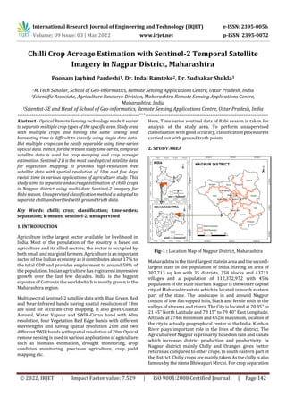
  • 1. International Research Journal of Engineering and Technology (IRJET) e-ISSN: 2395-0056 Volume: 09 Issue: 03 | Mar 2022 www.irjet.net p-ISSN: 2395-0072 © 2022, IRJET | Impact Factor value: 7.529 | ISO 9001:2008 Certified Journal | Page 142 Chilli Crop Acreage Estimation with Sentinel-2 Temporal Satellite Imagery in Nagpur District, Maharashtra Poonam Jayhind Pardeshi1, Dr. Indal Ramteke2, Dr. Sudhakar Shukla3 1M.Tech Scholar, School of Geo-informatics, Remote Sensing Applications Centre, Uttar Pradesh, India 2Scientific Associate, Agriculture Resource Division, Maharashtra Remote Sensing Applications Centre, Maharashtra, India 3Scientist-SE and Head of School of Geo-informatics, Remote Sensing Applications Centre, Uttar Pradesh, India ---------------------------------------------------------------------***---------------------------------------------------------------------- Abstract - Optical Remote Sensing technology made it easier to separate multiple crop types of the specific area. Studyarea with multiple crops and having the same sowing and harvesting time is difficult to classify using single date data. But multiple crops can be easily separable using time-series optical data. Hence, for thepresentstudytime-series, temporal satellite data is used for crop mapping and crop acreage estimation. Sentinel-2 B is the most used optical satellite data for vegetation mapping. It provides high-resolution free satellite data with spatial resolution of 10m and five days revisit time in various applications of agriculture study. This study aims to separate and acreage estimation of chilli crops in Nagpur district using multi-date Sentinel-2 imagery for Rabi season. Unsupervised classification method is adoptedto separate chilli and verified with ground truth data. Key Words: chilli; crop; classification; time-series; separation; k-means; sentinel-2; unsupervised 1. INTRODUCTION Agriculture is the largest sector available for livelihood in India. Most of the population of the country is based on agriculture and its allied sectors; the sector is occupied by both small and marginal farmers.Agricultureisanimportant sector of the Indian economy as it contributes about 17% to the total GDP and provides employment to around 58% of the population. Indian agriculture has registeredimpressive growth over the last few decades. India is the biggest exporter of Cotton in the world which is mostly grownin the Maharashtra region. Multispectral Sentinel-2 satellite data with Blue, Green, Red and Near-Infrared bands having spatial resolution of 10m are used for accurate crop mapping. It also gives Coastal Aerosol, Water Vapour and SWIR-Cirrus band with 60m resolution, four Vegetation Red Edge bands with different wavelengths and having spatial resolution 20m and two different SWIR bands with spatial resolution of 20m. Optical remote sensing is used in various applications of agriculture such as biomass estimation, drought monitoring, crop condition monitoring, precision agriculture, crop yield mapping etc. Here, Time series sentinel data of Rabi season is taken for analysis of the study area. To perform unsupervised classification with good accuracy, classificationprocedureis carried out with ground truth points. 2. STUDY AREA Fig-1 : Location Map of Nagpur District, Maharashtra Maharashtra is the third largest stateinarea andthesecond- largest state in the population of India. Having an area of 307,713 sq. km with 35 districts, 358 blocks and 43711 villages and a population of 112,372,972 with 45% population of the state is urban. Nagpur is the winter capital city of Maharashtra state which is located in north eastern part of the state. The landscape in and around Nagpur consist of low flat-topped hills, black and fertile soils in the valleys of streams and rivers. The City is located at 20 35‟ to 21 45‟ North Latitude and 78 15‟ to 79 40‟ East Longitude. Altitude at 274m minimum and 652m maximum, location of the city is actually geographical center of the India. Kanhan River plays important role in the lives of the district. The Agriculture of Nagpur is primarily based on rain and canals which increases district production and productivity. In Nagpur district mainly Chilly and Oranges gives better returns as compared to other crops. In south eastern part of the district, Chilly crops are mainly taken.Asthechillyisalso famous by the name Bhiwapuri Mirchi. For crop separation
  • 2. International Research Journal of Engineering and Technology (IRJET) e-ISSN: 2395-0056 Volume: 09 Issue: 03 | Mar 2022 www.irjet.net p-ISSN: 2395-0072 © 2022, IRJET | Impact Factor value: 7.529 | ISO 9001:2008 Certified Journal | Page 143 and acreage estimation of the district, data is acquired from the USGS Earth Explorer. 3. DATA AND SOFTWARE USED Data used: Sentinel-2b, Shape files of Nagpur district, Ground truth data Software: ArcGIS, Erdas Imagine, Google Earth Pro 4. METHODOLOGY Classification of different crops using remote sensing technology primarilydependsonthegrowingstagesofcrops and on crop season. Nagpur district takes multiple crops in Rabi season which includes gram, wheat, jowar, maize including chilli etc. For the classification of multiple crops, we used time-series data. There are two different classification techniques namely Supervised and Unsupervised classification. Supervised classification refers to the classification which uses trainingsamplescollected by the user in which software uses training pixels as references for classifying all other pixels of an image. Where the unsupervised classification uses software algorithms for classification of an image without any human intervention. Different temporal images of the Rabi season were downloaded for the month October, November, December and January of the year 2021 & 2022. Selected data were used for analysis with less than 20% of cloud cover. False colour composite images were obtained from band-2(Blue), band-3(Green), band-4(Red) & band-8(Visible and Near Infrared). Near-infrared (B8) band is good at reflecting chlorophyll which shows healthy vegetation in bright red. Raster layer of agriculture mask and Orchard mask layerare applied on stacked NDVI image of agriculture fields for masking out only agricultural area for classification. NDVI images of different dates are layer stacked together in order to obtain NDVI profile of crops. The Present study uses an unsupervised classification technique with the K-means clustering method. 50 classes were used with 0.999 convergence threshold for image processing. Where k-means is an algorithm that partitions ‘n” observations into ‘k’ clusters in which each observation belongs to the cluster with the nearest centroid. The images are classified into clusters having similarpixelsvalues.Mean NDVI reflectance value is calculated each class. For NDVI profile generation of each crop and for crop identification, NDVI versus different month graph is created for each class. Based on the NDVI reflectance values of crops and their varying curve within the course of crop growth, different crops were identified. Chart-1: Graphical representation of identified Chilli crops (Rabi Season: 2021-2022) Major crops taken in Rabi season areGramand Wheat which are taken abundantly. Some chilli fields are also taken in the district. Chilli crops are standing crops of Rabi season which can be easily interpreted based on their NDVI profile. Fig-2: Classified Map of Nagpur District for Chilli crop (Rabi Season: 2021-2022) Fig-3: Ground Truth points of Nagpur District for Chilli crop (Rabi Season: 2021-2022)
  • 3. International Research Journal of Engineering and Technology (IRJET) e-ISSN: 2395-0056 Volume: 09 Issue: 03 | Mar 2022 www.irjet.net p-ISSN: 2395-0072 © 2022, IRJET | Impact Factor value: 7.529 | ISO 9001:2008 Certified Journal | Page 144 5. RESULTS The estimated Chilli acreage is based on NDVI reflectance values obtained from sentinel-2 satellites. All chilli fieldsare identified as standing crop in Rabi season for the study area whose NDVI profile graph is increasing. Chilli crops are also identified by basic image interpretation where yellow patches near some of the Chilli fields showsthedriedchillies were placed nearby. Classification is achieved by studying the NDVI curve obtained for each class according to the crop growth timeline. The Accuracy of classification is verifiedby ground truth points. According to crop statistics we observed that acreage estimated for chilli crop is about 6461.55 hectares in the growing Rabi season. Table -1: Crop Statistics for Chilli crop, Nagpur (Rabi Season: 2021-2022) 6. CONCLUSION Time-series image classification can be used for multiple crop identification. NDVI image helps in identifyingaccurate crop fields with the help of multiple dates NDVI profile curve. The Obtained curve is based on NDVI reflectance value. K-Means unsupervised classification is performed with 50 classes is sufficient to identify different chilli crops and for estimating chilli crop acreage of the district. NDVI profile curve obtained for eachclassisobservedaccordingto crop duration and crop health. REFERENCES [1] Carlos, A. O. V., Paul M., Paul A. (2002).Agricultural Crop classification using the spectral-temporal response surface, Anais XI SBSR, Belo Horizonte, Brasil, 05-10 abril 2003, INPE, p. 255-262. [2] Rei S., Yuki Y., Hiroshi T., Xiufeng W., Nobuyuki K., Kan- ichiro M. (2018). Crop Classification from sentinel-2- derived vegetation indices using ensemble learning, J. Appl. Remote Sens. 12(2), 026019 (2018), doi: 10.1117/1.JRS.12.026019. [3] Nobuyuki K., Hiroshi T., Xiufeng W. & Rei S. (2019).Crop classification using spectral indices derived from Sentinel-2A imagery, Journal of Information and Telecommunication, DOI: 10.1080/24751839.2019.1694765. [4] Bhuyar N., Acharya S., Theng D. (2020). Crop Classification with Multi-Temporal SatelliteImageData, International Journal of Engineering Research & Technology, Vol. 9, 2278-0181. [5] Dimo D., Fabian L., Mirzahayot I., Galina S., Christopher C. (2017). SAR and optical time series for crop classification, DOI: 10.1109/IGARSS.2017.8127076. [6] Jingduo S., Minfeng X., Yichuan M., Long W., Kaiwei L., Xingwen Q. (2019). Crop Classification Using Multitemporal Landsat 8 Images, DOI: 10.1109/IGARSS.2019.8899274. [7] Raiyani K., Goncalves T., Rato L., Salgueiro P., Marques da Silva J. R.,.(2021). Sentinel-2 Image Scene Classification: A Comparison between Sen2Cor and a Machine Learning Approach. RemoteSens.2021,13,300. DOI: 10.3390/rs13020300. [8] Hejmanowska B., Kramarczyk P., Glowienka E.,MikrutS. (2021). Reliable Crops Classification Using Limited Number of Sentinel-2 and Sentinel-1 Images. Remote Sens. 2021,13,3176. DOI: 10.3390/rs13163176. [9] Katharina H., Daniel S., Sibylle I. (2018). A Progressive Crop-Type Classification Using Multitemporal Remote Sensing Data and Phenological Information. Journal of Photogrammetry, Remote Sensing and Geoinformation Science.2018, 86:53-69.DOI: 10.1007/s41064-018- 0050-7. [10] LatLong.net. Nagpur, India. https://www.latlong.net/place/nagpur-india-622.html [11] MapsofIndia.com.https://www.mapsofindia.com/nagpu r/businesseconomy/agriculture.html [12] District Nagpur. About District. https://nagpur.gov.in/ [13] Indian Village Directory. Nagpur. https://villageinfo.in/maharashtra/nagpur/nagpur- rural.html [14] Egyankosh.AccuracyAssessment.https://www.egyankos h.ac.in/bitstream/123456789/39544/1/Unit-14.pdf Tehsil Chilli Acreage as per Classification (Hectare) Mauda 1712.31 Kuhi 1483.57 Ramtek 1034.77 Kalameshwar 903.83 Umred 597.11 Bhiwapur 496.44 Parseoni 233.62 Total ( Nagpur) 6461.55
  • 4. International Research Journal of Engineering and Technology (IRJET) e-ISSN: 2395-0056 Volume: 09 Issue: 03 | Mar 2022 www.irjet.net p-ISSN: 2395-0072 © 2022, IRJET | Impact Factor value: 7.529 | ISO 9001:2008 Certified Journal | Page 145 [15] Geospatial Technology. What’s the difference betweena supervised and unsupervised image classification. https://mapasyst.extension.org/whats-the-difference- between-a-supervised-and-unsupervised-image- classification/ [16] Department of Agriculture & farmers Welfare. https://agricoop.nic.in/hi/agriculture-contingency- plan-listing [17] Department of Agriculture & farmers Welfare. https://agricoop.nic.in/sites/default/files/Maharashtra -SAP_V1.3-2.pdf [18] InsightsIAS.https://www.insightsonindia.com/agricultu re/role-of-agriculture-in-indian-economy/ [19] Agriculture Contingency Plan for District: NAGPUR. https://agricoop.nic.in/sites/default/files/MH18- %20Nagpur.pdf [20] Krishi Vigyan Kendra, Nagpur. http://kvknagpur.org.in/AboutNagpur.html [21] Nagpur district. https://en.wikipedia.org/wiki/Nagpur_district [22] AgricultureSeasons.https://gazetteers.maharashtra.gov. in/cultural.maharashtra.gov.in/english/gazetteer/Nagp ur/agri1.html#:~:text=The%20kharif%20season%20w hich%20commences,is%20received%20during%20this %20season