
Recommended
More Related Content
What's hot
What's hot (20)
Similar to Navigation glossary
Similar to Navigation glossary (20)
More from atshayaSundar
Recently uploaded
Recently uploaded (20)
Navigation glossary
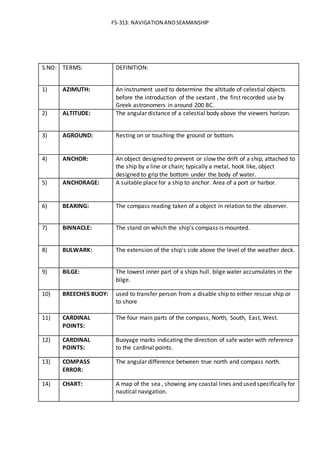
- 1. FS-313: NAVIGATION ANDSEAMANSHIP S.NO: TERMS: DEFINITION: 1) AZIMUTH: An instrument used to determine the altitude of celestial objects before the introduction of the sextant , the first recorded use by Greek astronomers in around 200 BC. 2) ALTITUDE: The angular distance of a celestial body above the viewers horizon. 3) AGROUND: Resting on or touching the ground or bottom. 4) ANCHOR: An object designed to prevent or slow the drift of a ship, attached to the ship by a line or chain; typically a metal, hook like, object designed to grip the bottom under the body of water. 5) ANCHORAGE: A suitable place for a ship to anchor. Area of a port or harbor. 6) BEARING: The compass reading taken of a object in relation to the observer. 7) BINNACLE: The stand on which the ship's compass is mounted. 8) BULWARK: The extension of the ship's side above the level of the weather deck. 9) BILGE: The lowest inner part of a ships hull. bilge water accumulates in the bilge. 10) BREECHES BUOY: used to transfer person from a disable ship to either rescue ship or to shore 11) CARDINAL POINTS: The four main parts of the compass, North, South, East, West. 12) CARDINAL POINTS: Buoyage marks indicating the direction of safe water with reference to the cardinal points. 13) COMPASS ERROR: The angular difference between true north and compass north. 14) CHART: A map of the sea , showing any coastal lines and used specifically for nautical navigation.
- 2. FS-313: NAVIGATION ANDSEAMANSHIP 15) COURSE: horizontal distance in which a vessel is steered or intended to be steered. 16) DUNNAGE: Loose packing material used to protect a ship's cargo from damage during transport. Personal baggage. 17) DEVIATION: The angular difference between compass north and magnetic north. 18) DOCKING: The procedure for coming alongside and securing to a wharf or jetty. 19) DEAD RECKONING: Is fixing of present position or expected future position, from a previous position using known direction and distances. 20) EQUATOR: The great circle whose plane is perpendicular to the polar axis, midway between the poles. 21) ECHO GRAM: Visual record of reflected echoes of sound transmitted by an echo sounder 22) FATHOM: A unit of measure equal to six feet, used to describe depth of water, or length of rope or line. 23) FETCH: The distance over water which the wind has blown uninterrupted. 24) FIX: A relatively accurate position determined without reference to any former position. 25) FLARE: A signal device to indicate distress, the external concave curve of the bow of a ship 26) GROUND TACKLE: A collective term used to embrace all of the gear used for anchoring or for securing a navigation buoy to the bottom. 27) GYRO COMPASS: A directional instrument that indicates gyro north, which can be very close to true north. 28) GALLEY: The kitchen in a ship or aircraft. 29) HEADING ( SHIPS HEAD) Is constantly changing value as ship oscillates or yaws across due to effects of sea & steering error.(or) the direction in which the ships head is pointed. 30) HALYARD: A rope used for hoisting sails, spars or flags.
- 3. FS-313: NAVIGATION ANDSEAMANSHIP 31) KNOT: A unit of speed equal to one nautical mile per hour. 32) KELLET: A heavy weight attached in the length of the anchor rope to reduce the angle of pull on the anchor. 33) LATITUDE: The angular distance of a point on the surface of the earth north or south of the equator as measured at the centre of the earth. 34) LEE SIDE: The side opposite to the direction from which the wind blows. 35) LIGHT HOUSE: A major light built as a manmade aid to navigation; may be manned or unmanned. 36) LOP(LINE OF POSITION): A line on the chart along which the vessel is known to lie. 37) LOG: A device that measures distance travelled through the water, from which speed can be calculated. 38) LONGITUDE: The angular distance east or west of prime meridian of the prime meridian of a point on the surface of the earth as measured at the polar axis. 39) LUBBER LINE: The reference line of a compass. 40) MAGNETIC COMPASS: A directional instrument actuated by the earths magnetic field. 41) MAY DAY : Mayday is an emergency procedure word used internationally as a distress signal in voice procedure radio communications. 42) MEDEVAC: Includes evacuation of a person from a vessel for medical reasons. 43) MERCATOR PROJECTION: The most common type of chart projection used for navigational charts. 44) MERCATOR CHART: A cylindrical map projection in which the meridian and parallel appear as lines crossing at right angles and in which areas appear greater farther from the equator. 45) MERIDIAN: An imaginary line joining the earths poles ,the prime meridian is the one that passes through Greenwich, England and represents zero longitude. 46) MAST HEAD LIGHT: white light placed at centre over an arc of horizon of225deg &22.5deg abaft the beam on either side.
- 4. FS-313: NAVIGATION ANDSEAMANSHIP 47) NAVIGATION: process of directing or conducting the movement of a vehicle /vessel from one place to another safely. 48) PELORUS: The navigation instrument used for taking visual bearings, having a card and an arc rotating sight bar with two sighting vanes. 49) PILOTING: Is navigating, using fixed points of reference on the sea or on land , usually with reference to a nautical chart or aeronautical chart to obtain a fix of the position of the vessel or aircraft with respect to a desired course or location. 50) PLOT: To draw lines on a chart indicating bearings, courses and positions. 51) RUNNING FIX: A position determined by the use of bearings that have an appreciable time difference in between them. 52) RHUMB LINE: a line crosses every meridian of sphere at same angle. 53) STERN LIGHT: white light, unbroken over an arc of horizon of 135deg &67.5deg each side. 54) SIDE LIGHT: green light, unbroken over an arc of horizon of 112.5 deg&52.5deg abaft the beam. 55) SKIPPER: The person in command of a vessel. 56) SEMAPHORE: Signalling by hand flags or arms. 57) SEASMANSHIP: The skill , techniques ,or practices of handling a ship or boat at sea. 58) TRUE WIND: The direction and velocity of the wind as observed from a stationary point 59) UNDERWAY: A vessel when not at anchor, aground or made fast to shore. 60) VARIATION: The angular difference between magnetic north and true north.