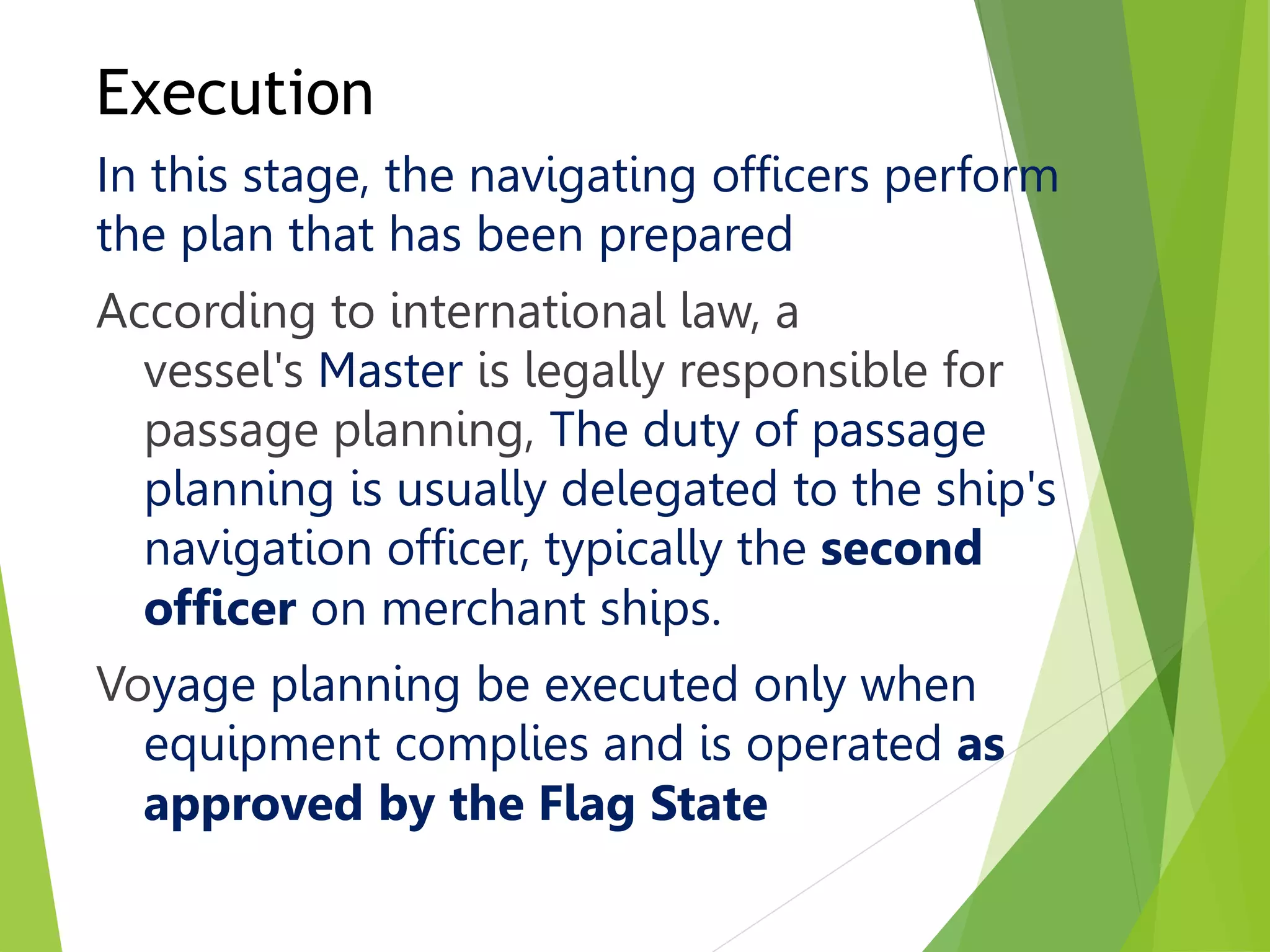
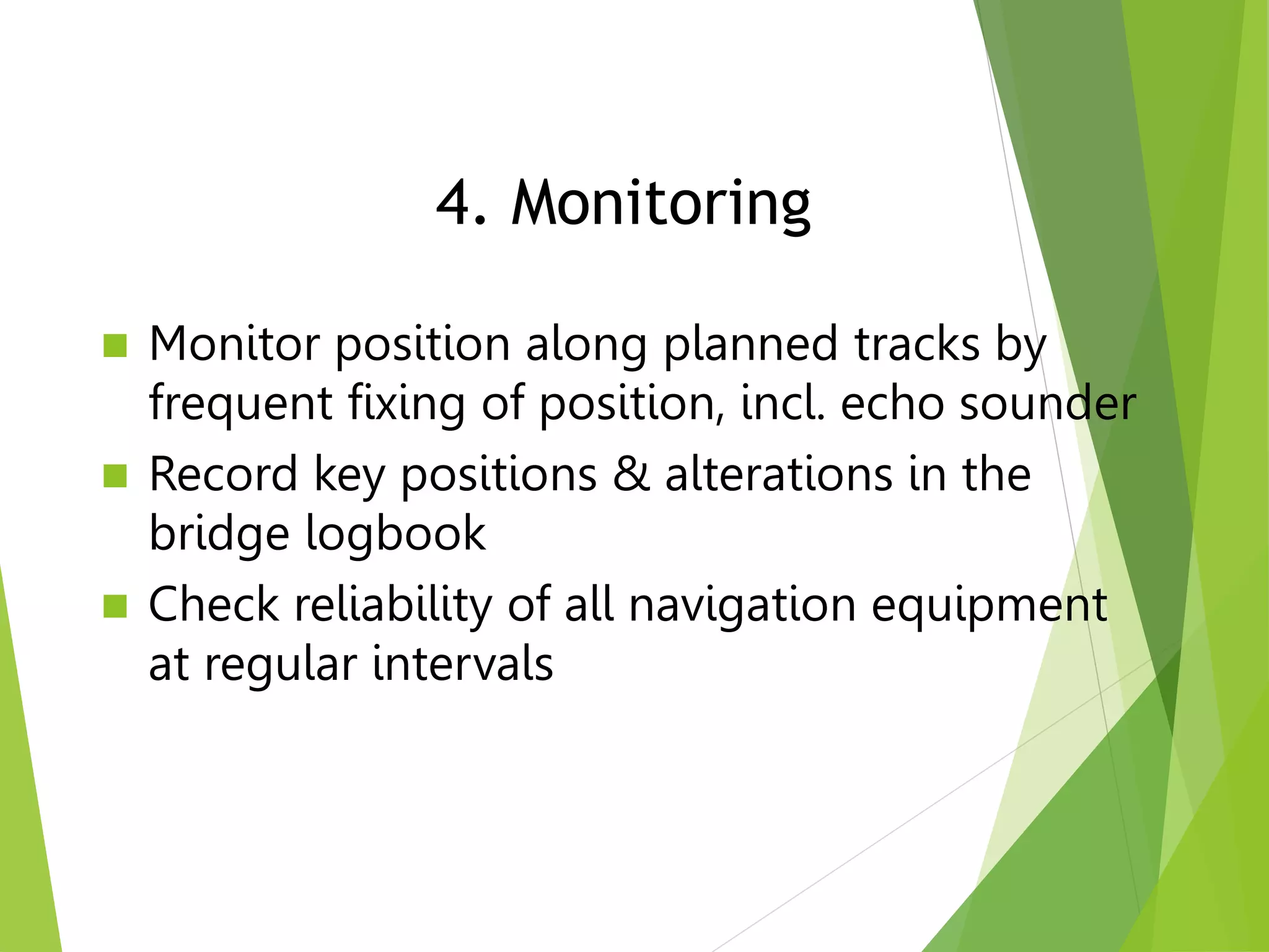
ECDIS: New standards & old underwater rocksLearnmarine
Webinar on: IHO S-52 Presentation Library 4.0, ECDIS as an anti-grounding device, Safety Contour and Safety Depth setup, information layers, utilities.
ECDIS: New standards & old underwater rocksLearnmarine
Webinar on: IHO S-52 Presentation Library 4.0, ECDIS as an anti-grounding device, Safety Contour and Safety Depth setup, information layers, utilities.
Mooring and Unmooring operation during berthing and un-berthing of vessel is critical. The cadets are weak links in the team till they gain some experience. This presentation would help cadets to understand ,appreciate hazards and consequences. They can do spot risk assessment based on learning from presentation. Hope this presentation will help in reducing accidents arising from Mooring Ops.
Thanks for watching the slides ,await for your inputs.
Capt. Vivek Trivedi
smrviv@yahoo.co.in
Reconnaissance for Hydrographic Surveying ProjectNzar Braim
Reconnaissance for Hydrographic
Surveying Project
This report talks about how the reconnaissance will be and it is effectively important the place that we survey and observation so the surveyor should prepare himself or herself for the project visiting site and site survey and planning and so on.
Observer visiting the site many times daily to see what is the situation and the condition and booking his or her notes recording them such as is the site ready to start the observation? Or is the site has safety to start? I mean replace safety conditions and also must have collected all this information and choose which instrument this site or this project and many other conditions should be considered after all above that I have mentioned he or she decides to start and beginning Project and surveying or not. This is the idea or this the outline recognizes.
Methods of Shore Observations for Horizontal position FixingNzar Braim
This report is about the methods of observations of the shore for fixing the horizontal
control position, I will try to explain the hydrographic engineering science within its
advantages and applications and the most common methods used in hydrography
briefly.
We knew that the depths of the water bodies at various points and will be changed
and unstable so Depths are determined by making sounding which is determining the
depth of water from the stationary boat and the positions of sounding can be determined
either from the boat from shore or both of them.
If we want to make a survey Project or let's say if a surveyor wants to make a survey
project for hydrographic surveying and observation for this project so he needs
many processes many preparations many techniques many tools equipment and
So For establishing horizontal control and vertical control points, we have many
methods either offshore or onshore or both I mean from a boat or shore or both
consequently, I wrote a report about this important t subject and In this report I
mention all methods and explain the three applicable and using methods that have
been used in hydrographic surveying and also mention which method is good or
better than the other and the advantages and disadvantages of these methods.At the end
my aim for preparing this report is to show the importance of hydrographic surveying
and how these methods can be used and all require and need for these methods and
also mention all steps, all equations that must be used for these methods.
Finally most important point I should mention it is a co-ordinated system or finding the
coordinates .the surveyor deals with the coordinates, so we make all these processes,
learning all methods, equations, formulas, steps, establishing control points, all above
just for one purpose which is finding the or calculating coordinate, and the most
the important thing in coordinate is accuracy, avoiding errors and uncertainty.
Welcome to the Program Your Destiny course. In this course, we will be learning the technology of personal transformation, neuroassociative conditioning (NAC) as pioneered by Tony Robbins. NAC is used to deprogram negative neuroassociations that are causing approach avoidance and instead reprogram yourself with positive neuroassociations that lead to being approach automatic. In doing so, you change your destiny, moving towards unlocking the hypersocial self within, the true self free from fear and operating from a place of personal power and love.
2. GUIDELINES FOR VOYAGE PLANNING
(IMO Resolution A.893(21)
Annex 25 of SOLAS V - GUIDELINES FOR
VOYAGE PLANNING
3. The main elements to ensure safety of life at
sea, safety and efficiency of navigation, and
protection of the marine environment during
the intended voyage or passage; such
elements should include, but not be limited
to: - Safe speed, having regard to the
proximity of navigational hazards along the
intended route or track, the manoeuvring
characteristics of the vessel and its draught
in relation to the available water depth
4. Guidelines for Voyage Planning
All information must be assembled as the
requirement is a plan covering from berth
to berth it therefore includes the period a
pilot will be on board. Voyage planning,
also referred to as passage planning, is
the detailed procedure of laying out a
vessel's voyage from start to finish.“
Voyage planning be done ”Prior to
sailing”
5. On the basis of the fullest possible
appraisal, a detailed voyage or passage
plan should be prepared which should cover
the entire voyage or passage from berth to
berth,
6. 1 Objectives
1.1 The development of a plan for voyage or
passage, as well as the close and continuous
monitoring of the vessel's progress and
position during the execution of such a plan,
are of essential importance for safety of life at
sea, safety and efficiency of navigation and
protection of the marine environment.
7. Introduction
Passage planning or voyage planning is a
procedure of developing a complete
description of a vessel's voyage from start to
finish.
Production of a passage plan prior to
departure is a legal requirement.
The practice of voyage planning has evolved
from drawing lines on nautical charts to a
process of risk management.]
8. What to include?
The plan should include:
leaving the dock and harbor area, the enroute
portion of a voyage, approaching the
destination, and mooring.
9. There are 4 stages in voyage
planning
1. Appraisal: collecting information
2. Planning: planning voyage from berth to
berth
3. Execution: update plan before departure
4. Monitoring: making sure ship keeps to
the plan
10.
11. 1. Appraisal
An appraisal of all information available
must be made before detailed plans can be
drawn up and a plan must be in existence
before tactics for its execution can be
decided upon. Once the plan and the
manner in which it is to be executed have
been decided, monitoring must be carried
out to ensure that the plan is followed.
12. 1. Appraisal
In this stage, the master of the ship discusses
with the chief navigating officer (usually the
Second Mate), as to how he intends to sail to the
destination port. (In some cases it may be
required for the master to plan the passage).
This is the process of gathering all information
relevant to the proposed passage, including
ascertaining risks and assessing its critical
areas. This involves information extracted from
publications as well as those within the chart.
13. 1. Appraisal
The appraisal stage consists of gathering and
contemplating all information relevant to the
voyage.
Appraisal Checklist
Great Circle or Rhumbline routes
TSS and shipping lanes, traffic, fishing vessels
ETD,ETA and speed of advance (SOA)
Meteorology Climate/weather
Limitations of ship, eg loadline changes
Limiting danger lines (LDL or no go lines)
Time zones
Availability of navaids
14. Appraisal
Correct charts are available and up to date
Sailing Directions, Light Lists, etc. available
Latest Notices to Mariners received
Tides, currents, weather information
Ship’s routeing and traffic volume expected
Port and pilot information
Any special requirements for the ship
15. Sailing Directions are written directions that
describe the routes to be taken by boats and
ships during coastal navigation and port
approaches.
ADMIRALTY Notices to Mariners are
weekly updates that provide bridge crews
with the latest safety-critical navigational
information.
16. A Light List is a detailed list of navigational
aids including lighthouses and other lighted
navigation aids, unlighted buoys,
radiobeacons, daybeacons, and racons. Light
lists are published by most of the major
maritime nations. Some nations, including the
United Kingdom and the United States,
publish lists that cover the whole world in
many volumes. Other nations publish lists
that cover only their own coasts.
17. Pilot Charts depict averages in prevailing
winds and currents, air and sea
temperatures, wave heights, ice limits,
visibility, barometric pressure, and weather
conditions at different times of the year. The
information used to compile these averages
was obtained from oceanographic and
meteorologic observations over many
decades during the late 18th and 19th
centuries.
18. The Atlas of Pilot Charts set is comprised of
five volumes, each covering a specific
geographic region. Each volume is an atlas of
twelve pilot charts, each depicting the
observed conditions for a particular month of
any given year.
The charts are intended to aid the navigator in
selecting the fastest and safest routes with
regards to the expected weather and ocean
conditions. The charts are not intended to be
used for navigation.
19. The Guide to Port Entry 2021 provides
accurate and comprehensive information on
over 14,700 global commercial ports and
terminals. With over 80 port information
sections, it ensures that a complete port
overview can be obtained before arrival,
including pre-arrival information, details of
the documentation required by the port,
maximum size of vessel permissible and
cargo facilities. It also includes reports of
actual conditions experienced by other
seafarers visiting that port..
20. ADMIRALTY List of Radio Signals
provides information on all aspects of
Maritime Radio Communications, helping
bridge crews to manage communications
and comply with all reporting regulations
throughout a voyage.
21.
22.
23. 2. Planning
The process involves projecting various
future events including landfalls, narrow
passages, and course changes expected
during the voyage.
The mental model becomes the standard by
which later on the navigator measures
progress toward the goal.
24. On the basis of the appraisal, a detailed
voyage plan is prepared
from berth to berth (even when a pilot is on
board)
drawn on the chart(s)
written in a bridge notebook
2. Planning
25. On the chart [with summary in bridge notebook]
tracks and courses to steer, where to alter
course/speed
highlight danger areas – wrecks, shallows, etc
identify electronic aids to navigation that can be
used
Identify good position fixing objects, e.g.
lights, transits, clearing bearings, radar/visual
objects
where the tide is critical, e.g height, or rate
alternative contingency plans
Planning (contd)
26. On the chart [with summary in bridge notebook]
tracks and courses to steer, where to alter
course/speed
highlight danger areas – wrecks, shallows, etc
identify electronic aids to navigation that can be
used
Identify good position fixing objects, e.g.
lights, transits, clearing bearings, radar/visual
objects
where the tide is critical, e.g height, or rate
alternative contingency plans
Planning (contd)
27. Necessary speed alterations en route, e.g.,
where there may be limitations because of
night passage, tidal restrictions, or allowance
for the increase of draught due to squat and
heel effect when turning;
28. Execution
In this stage, the navigating officers perform
the plan that has been prepared
According to international law, a
vessel's Master is legally responsible for
passage planning, The duty of passage
planning is usually delegated to the ship's
navigation officer, typically the second
officer on merchant ships.
Voyage planning be executed only when
equipment complies and is operated as
approved by the Flag State
29. When departure time is known, consider:
ETA at critical points in the plan
the weather forecast
traffic conditions
night or daylight passage
i.e. does anything need to be changed?
If the Officer of the watch must deviate from
the voyage plan, he should, Inform the
Master
3. Execution
30. Monitor position along planned tracks by
frequent fixing of position, incl. echo sounder
Record key positions & alterations in the
bridge logbook
Check reliability of all navigation equipment
at regular intervals
4. Monitoring
31. Monitoring
Once the voyage has begun the progress of
the vessel along its planned route must be
monitored. This requires that the ship's
position be determined.
32. Vessel Positioning Techniques
Vessel Positioning
By Cross Bearings
By Ranges of Two or More Points
By Combined Range and Bearing
By a Bearing and Sounding
By a Line of Soundings
By Running Fix
Position Fixing: The Most Important Element of
Passage Planning
33. Doubling the Angle on the Bow
The Four Point Bearing
The Transit Bearing
Danger or Clearing Bearings
Vertical Sextant Angle
Selection of Suitable Points for Bearings
and Radar Ranges
Vessel Positioning
35. Deviations
It is importnat to determine their source:
internal or
external reasons.
Possible reasons for deviations in maritime tr.:
bad weather conditions,
delays in ports,
route deviations (eg. due to medical condition of crew
memeber),
fuel price changes,
hull or engine condition,
poor planning etc.
36. Other planning
It is not only the navigation that needs to
be carefully planned. It is also necessary
to plan cargo loading (type of cargo,
volume, distribution aboard the etc.) and
unloading, port staying, bunker and
provisions, shipyard visit etc.