Download as PDF, PPTX


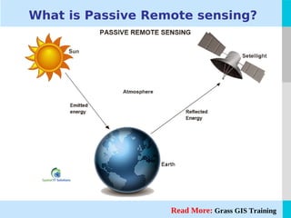


The document discusses passive remote sensing, a method that collects data about objects without physical contact, primarily using sensors that detect natural radiation such as sunlight. It highlights the characteristics and advantages of passive remote sensors, like their ability to capture multiple wavelengths and their low power requirements. Examples of passive remote sensing technologies include charge-coupled devices, infrared sensors, and film photography.


![Human presence detection based room light controller using pir2.pptx [repaired]](https://cdn.slidesharecdn.com/ss_thumbnails/humanpresencedetectionbasedroomlightcontrollerusingpir2-160418083434-thumbnail.jpg?width=640&height=640&fit=bounds)


![谷歌留痕技术 [ 𝙩𝙤𝙥 𝟮𝟯𝟯. 𝙘 𝙤𝙢 ]](https://cdn.slidesharecdn.com/ss_thumbnails/top233-260130174328-3833018c-thumbnail.jpg?width=640&height=640&fit=bounds)


