Downloaded 167 times
![Page 13
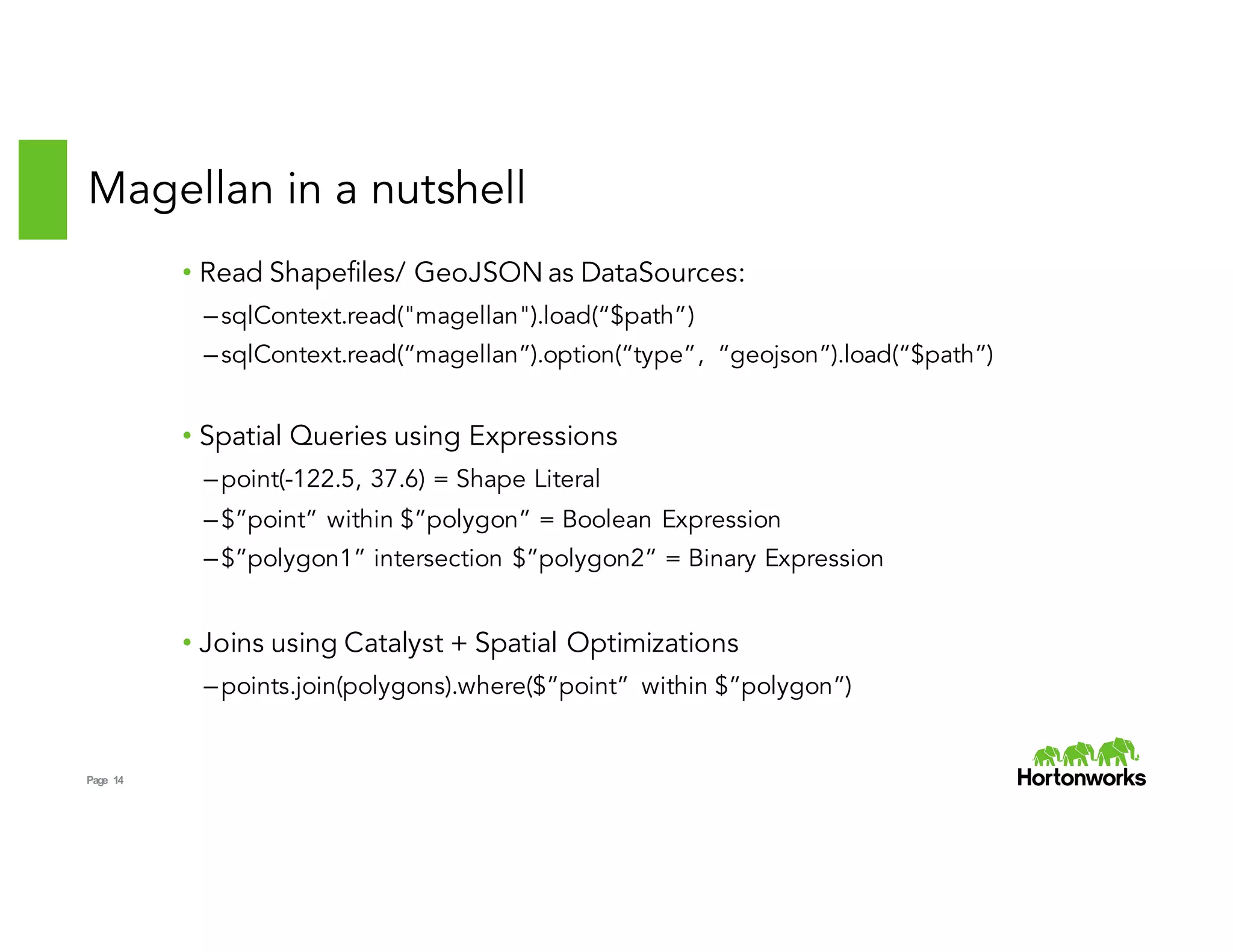
How does it work?
Custom Data Types for Shapes:
• Point, Line, PolyLine, Polygon extend Shape
• Local Computations using ESRI Java API
• No need for Scala -> SQL serialization
Expressions for Operators:
• Literals e.g point(-122.4, 37.6)
• Boolean Expressions e.g Intersects, Contains
• Binary Expressions e.g Intersection
Custom Data Sources:
• Schema = [point, polyline, polygon, metadata]
• Metadata = Map[String, String]
• GeoJSON and Shapefile implementations
Custom Strategies for Spatial Join:
• Broadcast Cartesian Join
• Geohash Join (in progress)
• Plug into Catalyst as experimental strategies](https://image.slidesharecdn.com/02ramsriharsha-151104001213-lva1-app6892/75/Magellen-Geospatial-Analytics-on-Spark-by-Ram-Sriharsha-13-2048.jpg)

Magellan provides geospatial analytics capabilities on Spark. It allows users to read geospatial data formats like Shapefiles and GeoJSON, perform spatial queries and joins on location data, and build complete geospatial analytics applications in Spark faster using their preferred programming languages like Python and Scala. Key features include custom data types for representing spatial objects, spatial expressions for queries, optimized strategies for spatial joins, and integration with Spark SQL's Catalyst optimizer.


![[FOSS4G KOREA 2014]Hadoop 상에서 MapReduce를 이용한 Spatial Big Data 집계와 시스템 구축](https://cdn.slidesharecdn.com/ss_thumbnails/foss4g2014hadoop-geohash-v02-140829035316-phpapp02-thumbnail.jpg?width=640&height=640&fit=bounds)


![[DSC Europe 25] Ivan Peric - Intelligence Swarm Logic and Techno-Functional M...](https://cdn.slidesharecdn.com/ss_thumbnails/7my7c97fsduiccadgavw-2-251212103249-5a03f7c6-thumbnail.jpg?width=640&height=640&fit=bounds)
![[DSC Europe 25] Miodrag Pesovic & Vladislav Radonjic - Federated Data Archite...](https://cdn.slidesharecdn.com/ss_thumbnails/gsbe3y5it5uhndi4e08e-1-251212103249-f1008e0c-thumbnail.jpg?width=640&height=640&fit=bounds)

![[DSC Europe 25] Ivan Petrovic - Is it really that expensive to build an AI sy...](https://cdn.slidesharecdn.com/ss_thumbnails/ybqhdwvusbg7jms3doxh-9-251216105605-7aab5a10-thumbnail.jpg?width=640&height=640&fit=bounds)

![[DSC Europe 25] Debmalya Biswas - Agentification: the art of transforming man...](https://cdn.slidesharecdn.com/ss_thumbnails/r5azlggvtqiaiiusrqdr-4-251212103249-5a12c89b-thumbnail.jpg?width=640&height=640&fit=bounds)
![[DSC Europe 25] Nikolay Burlutskiy - Best Practices for Building Enterprise M...](https://cdn.slidesharecdn.com/ss_thumbnails/uirvaiuvq8y1w8hzd9tx-7-251212103249-2619edb4-thumbnail.jpg?width=640&height=640&fit=bounds)

![[DSC Europe 25] Tatevik Maytesyan - How to actually use AI in marketing: gett...](https://cdn.slidesharecdn.com/ss_thumbnails/tjo626lsqdgfntbgl2mw-4-251216103155-e36cd239-thumbnail.jpg?width=640&height=640&fit=bounds)
![[DSC Europe 25] Djordje Hirs - Revolutionizing Telco Customer Experience with...](https://cdn.slidesharecdn.com/ss_thumbnails/zif75aur3qscnckv6tnc-djordje-hirs-cc-dsc2025-1-251219145617-679178aa-thumbnail.jpg?width=640&height=640&fit=bounds)
![[DSC Europe 25] Dobrica Cosic - From Electrons to Innovation: How Granular Da...](https://cdn.slidesharecdn.com/ss_thumbnails/h4qk69zereaumbceubgr-dobrica-cosic-from-electrons-to-innovation-how-granular-data-and-analytics-are--251218085301-b982fb14-thumbnail.jpg?width=640&height=640&fit=bounds)
![[DSC Europe 25] Uros Pesic - The Reality of AI in Marketing.pdf](https://cdn.slidesharecdn.com/ss_thumbnails/rtkodnmtycovsllvzsyn-9-251215095918-b0c6bfe3-thumbnail.jpg?width=640&height=640&fit=bounds)


![[DSC Europe 25] Maria Kokiasmenos - AI Governance US Perspective.pptx](https://cdn.slidesharecdn.com/ss_thumbnails/eszqnbzlsqa2vch6dmci-6-251215095918-6fcdf45f-thumbnail.jpg?width=640&height=640&fit=bounds)

