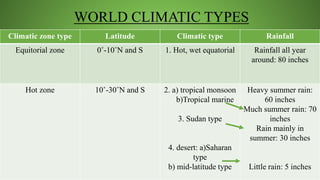
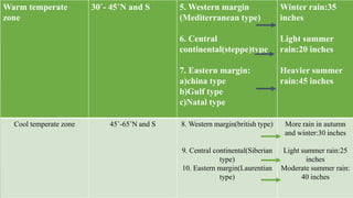
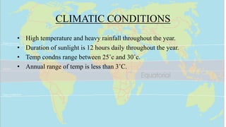
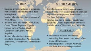
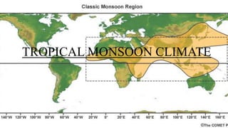
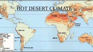
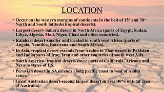
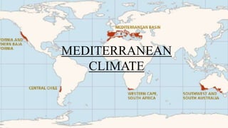
WORLD CLIMATE REGIONS
Dr. Rajalekshmy.p.r
Dept of Swasthavritta
Amrita School of Ayurveda
INTRODUCTION
• Climate is the condition of the atmosphere at a certain place
on earth.
• It is the long-term weather of an area and it includes
weather conditions, weather extremes, droughts and rainy
periods.
• Climatology is the study of climate.
• Climatic regions are areas with similar weather statistics.
INFLUENCING FACTORS
•Latitude
•Altitude
•Proximity to seas
•Air currents
•Land formation
LATITUDE
• A line of latitude is an
imaginary line which joins all
places having the same
angular distance north or
south of the equator.
• Equator 0°-longest line of
latitude.
• Two poles are points 90˚ N
and 90 ˚ S.
• Other important lines of
latitude are tropic of
cancer(23 1/2 ˚N), tropic of
Capricorn 23 1/2 ˚S), the
Arctic circle(66 1/2 ˚N) and
the Antarctic circle(66 1/2 ˚S).
ALTITUDE
• Height above sea level or the height above the earth's
surface.
• The higher the altitude, the lower the temperature will
be.
• On average for every 1,000 metres higher you go the
temperature will fall about 6.5 °C.
PROXIMITY TO SEAS
• Proximity to seas affects the temperature of a place because the sea
temperature changes slower than land temperature.
• So the sea will keep coastal areas warmer than inland area during the
winter and cooler than inland areas during the summer.
AIR CURRENTS
• Prevailing winds mainly affect the precipitation of a region.
• As prevailing winds pass over the ocean, it picks up water vapours.
• Eventually condensation takes place and it rains.
• Prevailing winds also can have an impact on the temperature of a
zone. For example, Because, winds coming from the north pole tend to
be cold and dry, the regions the wind passes over may also become
colder and drier.
LAND FORMATIONS
• Landforms affects the precipitation factor.
• Prevailing winds coming in from oceans usually
contain a lot of moisture.
• Now as the air is forced up the windward side of a
mountain, the air cools and condenses causing
precipitation.
• Because all the moisture is lost on the windward
side of the mountain, the leeward side receives no
precipitation.
• This process is called the rain shadow effect.
• The presence of such land formation can cause
some areas of a zone to receive more precipitation
than others.
COMPONENTS
INSOLATION
incoming solar radiation-
radiant energy received
by the earth.
TEMPERATURE
how hot or cold the atmosphere
is – i.e, how many degrees
Celsius (centigrade) it is above
or below freezing (0°C)point.
ATMOSPHERIC PRESSURE
The weight of air resting on the
earth's surface.
Pressure is shown on a weather
map, often called a synoptic map,
with lines called isobars.
PRECIPITATION
moisture that falls from the
air to the ground.
WIND
the movement of air masses from
high pressure areas (high) to low
pressure areas (low).
The effect of this movement of
air is to rebalance the pressure in
the atmosphere.
66 1/2°S 66 1/2°S
SOUTH FRIGID ZONE
66 1/2°N
66 1/2°NNORTH FRIGID ZONE
23 1/2°N
23 1/2°S
NORTH TEMPERATE ZONE
TROPICAL OR TORRIDZONE
SOUTH TEMPERATE ZONE
WORLD CLIMATIC TYPES
Climatic zone type Latitude Climatic type Rainfall
Equitorial zone 0˚-10˚N and S 1. Hot, wet equatorial Rainfall all year
around: 80 inches
Hot zone 10˚-30˚N and S 2. a) tropical monsoon
b)Tropical marine
3. Sudan type
4. desert: a)Saharan
type
b) mid-latitude type
Heavy summer rain:
60 inches
Much summer rain: 70
inches
Rain mainly in
summer: 30 inches
Little rain: 5 inches
Warm temperate
zone
30˚- 45˚N and S 5. Western margin
(Mediterranean type)
6. Central
continental(steppe)type
7. Eastern margin:
a)china type
b)Gulf type
c)Natal type
Winter rain:35
inches
Light summer
rain:20 inches
Heavier summer
rain:45 inches
Cool temperate zone 45˚-65˚N and S 8. Western margin(british type)
9. Central continental(Siberian
type)
10. Eastern margin(Laurentian
type)
More rain in autumn
and winter:30 inches
Light summer rain:25
inches
Moderate summer rain:
40 inches
Cold zone 65˚- 90˚N and S 11. Arctic or
polar
Very light
summer rain: 10
inches
Alpine zone 12. Mountain
climate
Heavy
rainfall(variable)
EQUITORIAL CLIMATE
LOCATION
• Extends generally between 10˚N and 10˚S latitudes.
• Includes parts of Asia, Africa and South America which are crossed by
equator.
• Africa- Zaire(Congo basin), the Guinea coast in West Africa.
• South America- Amazon Basin, coastal Columbia.
• Asia- Malaysia, Indonesia, Papua in New Guinea, Indonesia and
peninsular part of Thailand.
CLIMATIC CONDITIONS
• High temperature and heavy rainfall throughout the year.
• Duration of sunlight is 12 hours daily throughout the year.
• Temp condns range between 25˚c and 30˚c.
• Annual range of temp is less than 3˚C.
RAINFALL
• Receives high annual rainfall.
• Rainfall well distributed during all the months of the year.
• Amount ranges from 150 cm to 350 cm or more.
• Periods of maximum rainfall- April and October/November
• Least rainfall- June and December
• Rainfall occurs almost everyday in afternoon b/w 12 noon & 3
p.m.
• Torrential rainfall accompanied by thunder and lightning.
• Combination of high temperature and high humidity.
TROPICAL SUDAN CLIMATE
LOCATION
• The tropical grassland/Savanna region occurs in the transitional zone
b/w equatorial forest region and tropical deserts.
• Latitudinal limits- 10˚ N to 20˚ S
• Savanna is distributed in the southern continents of Africa, South
America and Australia.
AFRICA
• Savanna are most extensive, covering a
belt around equatorial region in both
hemispheres.
• Northern hemisphere- interior areas of
West Africa.
• Includes parts of Senegal, Mali, Ivory
Coast, Ghana, Togo and Nigeria.
• Covers parts of Sudan, Chad,
Cameroon and Central African
Republic.
• Southern hemisphere- tropical
grassland cover parts of Angola, zaire,
Zimbabwe, Mozambique, Tanzania and
Kenya.
SOUTH AMERICA
• Grasslands occur in two separate areas.
• Larger one covers interior parts of Brazilian
highlands and regions of Bolivia and
Northern Argentina.
• Smaller area lies to north of equator and
covers the Guiana highlands and Orinoco
basin in parts of Venezuela and Colombia.
AUSTRALIA
• Grasslands occur as a wide belt
extending from west to east, north of the
tropic of Capricorn .
• Includes parts of Western Australia,
Northern Territory and Queensland.
CLIMATIC CONDITIONS
• Hot wet summers and warm dry winters
• Mean monthly temp in summer->30˚C
• Northern hemisphere- though sun is overhead in June, hottest month is
April or May.
• Southern hemisphere-October or November is the hottest month not
December.
• Temp in winter-20˚C
• Annual range of temp-10˚C
• Diurnal range of temp is 15-20˚C
RAINFALL
• Gets moderate annual rainfall, varies from 125 cm on the margin of
equatorial region to 25 cm on the margin of tropical desert.
• Rainfall occurs in the summer season.
• Torrential rainfall associated with thunderstorms.
• Dry trade winds blowing over West Africa in winter are called
Harmattan(doctor).
• Relief from humid air of the Guiana coastlands and encourage
evaporation, which has cooling effect on skin.
TROPICAL MONSOON CLIMATE
DISTRIBUTION
• This climatic belt lies roughly b/w 10° and 25° North and South
of the equator; Indian Subcontinent extends to 30° N.
• Areas with tropical monsoon climate are India, Pakistan,
Bangladesh, Srilanka, Myanmar, Southern China, Cambodia,
Vietnam, the islands of Hainan, Taiwan, Philippines, Central
America, West Indies, Madagascar, Guinea Coast and Eastern
Brazil.
CLIMATIC CONDITIONS
• In summer when sun is overhead on Tropic of Cancer and Northern
hemisphere is intensely heated low pressure in Central Asia.
• High pressure develops in southern hemisphere in interiors of Australia.
• Wind blows outward from Australia as South East monsoon but on
crossing equator get deflected towards west and drawn towards low
pressure areas in Indian Subcontinent, blowing as South West monsoon.
• In winter, sun is overhead on tropic of Capricorn.
• Central Asia is cold, high pressure is created with out blowing dry winds-
North East Monsoon.
• On crossing equator, winds are drawn to low pressure centre in Australia ,
blowing as North West Monsoon.
SEASONS
COOL DRY SEASON
• October-February
• North East monsoon prevailing-winds
are dry but from Bay of Bengal, they
pick up moisture which is deposited in
South East Indian Peninsula(70 cm of
rain).
• Skies are clear and temperature are low.
HOT DRY SEASON
• March to mid June
• Temp rises sharply with sun’s
apparent movement northwards to
tropic of cancer.
• Intense heat, low relative humidity
and clear skies make day temp
unbearable(35° C).
• Coastal regions experience relief
due to moderating influence of sea.
• Dust storms in north are very
common.
RAINY SEASON
• Mid June to end of September
• Torrential rain experienced
across the country with south
west monsoon.
• Maximum rainfall in these 4
months.
• Coastal areas and windward
slopes of mountain experience
300 cm of rain.
RETREATING MONSOON
• October-November
• South west monsoon begins to leave
the shores of India and North west
monsoon advances towards north.
HOT DESERT CLIMATE
LOCATION
• Occur on the western margins of continents in the belt of 15° and 30°
North and South latitude(tropical deserts).
• Largest desert- Sahara desert in North Africa (parts of Egypt, Sudan,
Libya, Algeria, Mali, Niger, Chad and other countries).
• Kalahari desert-smaller and located in south west Africa (parts of
Angola, Namibia, Botswana and South Africa).
• In Asia, tropical desert extends from Arabia to Thar desert in Pakistan
and India(parts of Iraq, Iran and other countries of south west Asia.
• North America- tropical deserts cover parts of California, Arizona and
Nevada states of US.
• Peruvian desert in SA extends along pacific coast to west of Andes
range.
• Great Australian desert-second largest desert in area(40% of total area
of Australia).
CLIMATIC CONDITIONS
• Hot deserts get less than 25 cm annual rainfall.
• Desert are located in sub tropical high pressure belts.
• Regions of descending air warming of air high pressure
reduced R.humidity
• No possibility of rainfall in these regions.
CHARACTERISTICS
• Western margins are extremely dry because trade winds blow towards
them from interior of continents as off-shore winds.
• Hottest month has mean temp less than 30° C.
• During night, clear skies encourage rapid radiation of heat from land
and temp falls rapidly.
• Diurnal range of temp varies from 20°C to 30°C.
• Night temp during summer may drop to less than 20° C.
• During winter, coolest month may have temp of less than 20° C.
• Annual range of temp -15° C
MEDITERRANEAN
CLIMATE
MEDITERRANEAN REGIONS
• Land along the margins of the Mediterranean sea in Europe, Asia and
Africa.
• Europe- south Portugal, Spain, France, Italy, Yugoslavia, Greece.
• Asia- parts of coastal areas of Turkey, Syria, Lebanon and Israel
• Africa- coastal areas of Algeria, Morocco, Libya, Tunisia
• Region around Cape town in South Africa
• Warm dry summers and cool wet winters.
• Receives moderate rainfall.
• Summer- mean temp of hottest month is 20-25° C.
• During day time, temp may reach maximum of 30° C.
• Nights are cool in summer as clear skies radiate heat rapidly from
earth’s surface.
• During winter, mean temp of coolest month varies b/w 5° and 15° C.
• Frosts occurs rarely and only night temp falls below 0° C.
CLIMATIC CONDITIONS
LOCAL WINDS
• Local winds causes sudden changes in temp.
• Southern shores of Mediterranean seas are affected by hot and dry
winds, called Sirocco(blows from Sahara desert and carry a large
amount of dust).
• Santa Ana-hot dry wind that blows from desert region towards Los
Angeles region of California.
• During winter, cold local winds called Mistral descends from Alpine
ranges along Rhine valley of S.France (great force damages cultivated
crops and trees).
RAINFALL
• Moderate rainfall in winter and drought in summer.
• Annual rainfall: 35 cm-75 cm.
• Rainfall is minimum along margins of desert.
• Maximum rainfall received on hill range adjoining the coast.
• Clear skies and sunshine are common throughout the year.
• Bright sunny weather attracts tourists throughout the year.
TEMPERATE
CONTINENTAL CLIMATE
LOCATION
• Located in interior of continents, in middle latitudes of 40°-55° north
and South.
• In Europe, temperate grasslands extend to north of Black Sea and
Caspian Sea.
• In Asia, grasslands extend eastwards into west Siberia, north China
and Manchuria.
• North America-cover parts of United States and Canada.
• South America-cover parts of Argentina and Uruguay.
CLIMATIC CONDITIONS
• Short warm summer and long cold winter.
• Rainfall is moderate and variable.
• During summer, hottest month has temp of 15°-25° C.
• Maximum temp during day time may exceed 30° C.
• Clear skies favour rapid heating of land during day.
• During night, clear skies allow rapid radiation of heat from land.
• Diurnal range of temp is quiet large.
• During winter, land is covered with snow with only few hours of
sunshine.
• Annual range of temp: 20°-25° C.
RAINFALL
• Annual rainfall varies from 25cm to 60cm.
• Rainfall is accompanied with thunder and lightening.
• Rainfall comes in light showers spread over many rainy days.
• Snowfall during winter season.
TEMPERATE
CONTINENTAL(SIBERIAN)
CLIMATE
LOCATION
• The coniferous forests, Taiga region occurs as a broad continuous belt
in the latitudinal zone of about 55° N to 70° N.
• Occurs b/w Tundra region to north and temperate grassland region to
the south.
• Covers northern part of Scandinavia(Norway, Sweden and Finland).
• North America-covers parts of Southern Alaska and Canada and
extends from pacific coast to Atlantic Coast.
CLIMATIC CONDITIONS
• Short warm summer season of 4 months and long cold winter season.
• Summer- warmest month have mean temp of 20° C.
• Max temp during daytime reaches 30° C.
• Winter season lasts for 8-9 months with mean temp of coldest month
less than -10° C.
• Duration of sunlight may be about five or six hours only.
• Cold polar winds blow over Canada and Europe called blizzards.
RAINFALL
• Average rainfall is about 50cm.
• Varies from 30-100cm depending on distance from seas.
• Rainfall is distributed throughout the year and there is no marked dry
season.
• Maximum rainfall in summer.
• During winter, snowfall is common.
• An under layer of permafrost in some areas.
ARCTIC CLIMATE
LOCATION
• Tundra region occurs in North Polar region beyond the Arctic
circle.
• Tundra region covers coastal strips of Arctic ocean in North
America, Europe and Asia.
• The main areas are coastal strips of Alaska, Canada and
Greenland.
CLIMATIC CONDITIONS
• Short cool summer and long cold winter.
• On June 21 , when sun is overhead over tropic of cancer, Arctic region
experiences Midnight Sun i.e, sun neither rises nor sets.
• All places north of the Arctic circle see the sun throughout the
summer, while south of Antartica sun does not rise during this period.
• Converse condns occur when sun shines on tropic of Capricorn on Dec
23.
• Summer- Sun never sets for two or three months, remains over horizon
at a low angle.
• Warmest month has temp of less than 10° C.
• Mean temp of winter season is about -30° C.
• Permanently frozen subsoil-permafrost.
RAINFALL
• Cold desert
• Annual rainfall less than 25cm.
• Rainfall is of cyclonic origin owing to the ascent of warm air from
south over cold air from north.
• Coastal regions receive maximum rainfall in autumn or winter.
• Precipitation occurs in the form of rainfall, snowfall or sleet.
• Accumulation of snow which has fallen for many years.
• Only a thin surface layer of snow gets melted during the short summer
season.
World climate regions

World climate regions

  • 1.
    WORLD CLIMATE REGIONS Dr.Rajalekshmy.p.r Dept of Swasthavritta Amrita School of Ayurveda
  • 2.
    INTRODUCTION • Climate isthe condition of the atmosphere at a certain place on earth. • It is the long-term weather of an area and it includes weather conditions, weather extremes, droughts and rainy periods. • Climatology is the study of climate. • Climatic regions are areas with similar weather statistics.
  • 3.
  • 4.
    LATITUDE • A lineof latitude is an imaginary line which joins all places having the same angular distance north or south of the equator. • Equator 0°-longest line of latitude. • Two poles are points 90˚ N and 90 ˚ S. • Other important lines of latitude are tropic of cancer(23 1/2 ˚N), tropic of Capricorn 23 1/2 ˚S), the Arctic circle(66 1/2 ˚N) and the Antarctic circle(66 1/2 ˚S).
  • 5.
    ALTITUDE • Height abovesea level or the height above the earth's surface. • The higher the altitude, the lower the temperature will be. • On average for every 1,000 metres higher you go the temperature will fall about 6.5 °C.
  • 6.
    PROXIMITY TO SEAS •Proximity to seas affects the temperature of a place because the sea temperature changes slower than land temperature. • So the sea will keep coastal areas warmer than inland area during the winter and cooler than inland areas during the summer.
  • 7.
    AIR CURRENTS • Prevailingwinds mainly affect the precipitation of a region. • As prevailing winds pass over the ocean, it picks up water vapours. • Eventually condensation takes place and it rains. • Prevailing winds also can have an impact on the temperature of a zone. For example, Because, winds coming from the north pole tend to be cold and dry, the regions the wind passes over may also become colder and drier.
  • 8.
    LAND FORMATIONS • Landformsaffects the precipitation factor. • Prevailing winds coming in from oceans usually contain a lot of moisture. • Now as the air is forced up the windward side of a mountain, the air cools and condenses causing precipitation. • Because all the moisture is lost on the windward side of the mountain, the leeward side receives no precipitation. • This process is called the rain shadow effect. • The presence of such land formation can cause some areas of a zone to receive more precipitation than others.
  • 9.
    COMPONENTS INSOLATION incoming solar radiation- radiantenergy received by the earth. TEMPERATURE how hot or cold the atmosphere is – i.e, how many degrees Celsius (centigrade) it is above or below freezing (0°C)point. ATMOSPHERIC PRESSURE The weight of air resting on the earth's surface. Pressure is shown on a weather map, often called a synoptic map, with lines called isobars. PRECIPITATION moisture that falls from the air to the ground. WIND the movement of air masses from high pressure areas (high) to low pressure areas (low). The effect of this movement of air is to rebalance the pressure in the atmosphere.
  • 11.
    66 1/2°S 661/2°S SOUTH FRIGID ZONE 66 1/2°N 66 1/2°NNORTH FRIGID ZONE 23 1/2°N 23 1/2°S NORTH TEMPERATE ZONE TROPICAL OR TORRIDZONE SOUTH TEMPERATE ZONE
  • 12.
    WORLD CLIMATIC TYPES Climaticzone type Latitude Climatic type Rainfall Equitorial zone 0˚-10˚N and S 1. Hot, wet equatorial Rainfall all year around: 80 inches Hot zone 10˚-30˚N and S 2. a) tropical monsoon b)Tropical marine 3. Sudan type 4. desert: a)Saharan type b) mid-latitude type Heavy summer rain: 60 inches Much summer rain: 70 inches Rain mainly in summer: 30 inches Little rain: 5 inches
  • 13.
    Warm temperate zone 30˚- 45˚Nand S 5. Western margin (Mediterranean type) 6. Central continental(steppe)type 7. Eastern margin: a)china type b)Gulf type c)Natal type Winter rain:35 inches Light summer rain:20 inches Heavier summer rain:45 inches Cool temperate zone 45˚-65˚N and S 8. Western margin(british type) 9. Central continental(Siberian type) 10. Eastern margin(Laurentian type) More rain in autumn and winter:30 inches Light summer rain:25 inches Moderate summer rain: 40 inches
  • 14.
    Cold zone 65˚-90˚N and S 11. Arctic or polar Very light summer rain: 10 inches Alpine zone 12. Mountain climate Heavy rainfall(variable)
  • 15.
  • 16.
    LOCATION • Extends generallybetween 10˚N and 10˚S latitudes. • Includes parts of Asia, Africa and South America which are crossed by equator. • Africa- Zaire(Congo basin), the Guinea coast in West Africa. • South America- Amazon Basin, coastal Columbia. • Asia- Malaysia, Indonesia, Papua in New Guinea, Indonesia and peninsular part of Thailand.
  • 17.
    CLIMATIC CONDITIONS • Hightemperature and heavy rainfall throughout the year. • Duration of sunlight is 12 hours daily throughout the year. • Temp condns range between 25˚c and 30˚c. • Annual range of temp is less than 3˚C.
  • 18.
    RAINFALL • Receives highannual rainfall. • Rainfall well distributed during all the months of the year. • Amount ranges from 150 cm to 350 cm or more. • Periods of maximum rainfall- April and October/November • Least rainfall- June and December • Rainfall occurs almost everyday in afternoon b/w 12 noon & 3 p.m. • Torrential rainfall accompanied by thunder and lightning. • Combination of high temperature and high humidity.
  • 19.
  • 20.
    LOCATION • The tropicalgrassland/Savanna region occurs in the transitional zone b/w equatorial forest region and tropical deserts. • Latitudinal limits- 10˚ N to 20˚ S • Savanna is distributed in the southern continents of Africa, South America and Australia.
  • 21.
    AFRICA • Savanna aremost extensive, covering a belt around equatorial region in both hemispheres. • Northern hemisphere- interior areas of West Africa. • Includes parts of Senegal, Mali, Ivory Coast, Ghana, Togo and Nigeria. • Covers parts of Sudan, Chad, Cameroon and Central African Republic. • Southern hemisphere- tropical grassland cover parts of Angola, zaire, Zimbabwe, Mozambique, Tanzania and Kenya. SOUTH AMERICA • Grasslands occur in two separate areas. • Larger one covers interior parts of Brazilian highlands and regions of Bolivia and Northern Argentina. • Smaller area lies to north of equator and covers the Guiana highlands and Orinoco basin in parts of Venezuela and Colombia. AUSTRALIA • Grasslands occur as a wide belt extending from west to east, north of the tropic of Capricorn . • Includes parts of Western Australia, Northern Territory and Queensland.
  • 22.
    CLIMATIC CONDITIONS • Hotwet summers and warm dry winters • Mean monthly temp in summer->30˚C • Northern hemisphere- though sun is overhead in June, hottest month is April or May. • Southern hemisphere-October or November is the hottest month not December. • Temp in winter-20˚C • Annual range of temp-10˚C • Diurnal range of temp is 15-20˚C
  • 23.
    RAINFALL • Gets moderateannual rainfall, varies from 125 cm on the margin of equatorial region to 25 cm on the margin of tropical desert. • Rainfall occurs in the summer season. • Torrential rainfall associated with thunderstorms. • Dry trade winds blowing over West Africa in winter are called Harmattan(doctor). • Relief from humid air of the Guiana coastlands and encourage evaporation, which has cooling effect on skin.
  • 24.
  • 25.
    DISTRIBUTION • This climaticbelt lies roughly b/w 10° and 25° North and South of the equator; Indian Subcontinent extends to 30° N. • Areas with tropical monsoon climate are India, Pakistan, Bangladesh, Srilanka, Myanmar, Southern China, Cambodia, Vietnam, the islands of Hainan, Taiwan, Philippines, Central America, West Indies, Madagascar, Guinea Coast and Eastern Brazil.
  • 26.
    CLIMATIC CONDITIONS • Insummer when sun is overhead on Tropic of Cancer and Northern hemisphere is intensely heated low pressure in Central Asia. • High pressure develops in southern hemisphere in interiors of Australia. • Wind blows outward from Australia as South East monsoon but on crossing equator get deflected towards west and drawn towards low pressure areas in Indian Subcontinent, blowing as South West monsoon. • In winter, sun is overhead on tropic of Capricorn. • Central Asia is cold, high pressure is created with out blowing dry winds- North East Monsoon. • On crossing equator, winds are drawn to low pressure centre in Australia , blowing as North West Monsoon.
  • 27.
    SEASONS COOL DRY SEASON •October-February • North East monsoon prevailing-winds are dry but from Bay of Bengal, they pick up moisture which is deposited in South East Indian Peninsula(70 cm of rain). • Skies are clear and temperature are low. HOT DRY SEASON • March to mid June • Temp rises sharply with sun’s apparent movement northwards to tropic of cancer. • Intense heat, low relative humidity and clear skies make day temp unbearable(35° C). • Coastal regions experience relief due to moderating influence of sea. • Dust storms in north are very common.
  • 28.
    RAINY SEASON • MidJune to end of September • Torrential rain experienced across the country with south west monsoon. • Maximum rainfall in these 4 months. • Coastal areas and windward slopes of mountain experience 300 cm of rain. RETREATING MONSOON • October-November • South west monsoon begins to leave the shores of India and North west monsoon advances towards north.
  • 29.
  • 30.
    LOCATION • Occur onthe western margins of continents in the belt of 15° and 30° North and South latitude(tropical deserts). • Largest desert- Sahara desert in North Africa (parts of Egypt, Sudan, Libya, Algeria, Mali, Niger, Chad and other countries). • Kalahari desert-smaller and located in south west Africa (parts of Angola, Namibia, Botswana and South Africa). • In Asia, tropical desert extends from Arabia to Thar desert in Pakistan and India(parts of Iraq, Iran and other countries of south west Asia. • North America- tropical deserts cover parts of California, Arizona and Nevada states of US. • Peruvian desert in SA extends along pacific coast to west of Andes range. • Great Australian desert-second largest desert in area(40% of total area of Australia).
  • 31.
    CLIMATIC CONDITIONS • Hotdeserts get less than 25 cm annual rainfall. • Desert are located in sub tropical high pressure belts. • Regions of descending air warming of air high pressure reduced R.humidity • No possibility of rainfall in these regions.
  • 32.
    CHARACTERISTICS • Western marginsare extremely dry because trade winds blow towards them from interior of continents as off-shore winds. • Hottest month has mean temp less than 30° C. • During night, clear skies encourage rapid radiation of heat from land and temp falls rapidly. • Diurnal range of temp varies from 20°C to 30°C. • Night temp during summer may drop to less than 20° C. • During winter, coolest month may have temp of less than 20° C. • Annual range of temp -15° C
  • 33.
  • 34.
    MEDITERRANEAN REGIONS • Landalong the margins of the Mediterranean sea in Europe, Asia and Africa. • Europe- south Portugal, Spain, France, Italy, Yugoslavia, Greece. • Asia- parts of coastal areas of Turkey, Syria, Lebanon and Israel • Africa- coastal areas of Algeria, Morocco, Libya, Tunisia • Region around Cape town in South Africa
  • 35.
    • Warm drysummers and cool wet winters. • Receives moderate rainfall. • Summer- mean temp of hottest month is 20-25° C. • During day time, temp may reach maximum of 30° C. • Nights are cool in summer as clear skies radiate heat rapidly from earth’s surface. • During winter, mean temp of coolest month varies b/w 5° and 15° C. • Frosts occurs rarely and only night temp falls below 0° C. CLIMATIC CONDITIONS
  • 36.
    LOCAL WINDS • Localwinds causes sudden changes in temp. • Southern shores of Mediterranean seas are affected by hot and dry winds, called Sirocco(blows from Sahara desert and carry a large amount of dust). • Santa Ana-hot dry wind that blows from desert region towards Los Angeles region of California. • During winter, cold local winds called Mistral descends from Alpine ranges along Rhine valley of S.France (great force damages cultivated crops and trees).
  • 37.
    RAINFALL • Moderate rainfallin winter and drought in summer. • Annual rainfall: 35 cm-75 cm. • Rainfall is minimum along margins of desert. • Maximum rainfall received on hill range adjoining the coast. • Clear skies and sunshine are common throughout the year. • Bright sunny weather attracts tourists throughout the year.
  • 38.
  • 39.
    LOCATION • Located ininterior of continents, in middle latitudes of 40°-55° north and South. • In Europe, temperate grasslands extend to north of Black Sea and Caspian Sea. • In Asia, grasslands extend eastwards into west Siberia, north China and Manchuria. • North America-cover parts of United States and Canada. • South America-cover parts of Argentina and Uruguay.
  • 40.
    CLIMATIC CONDITIONS • Shortwarm summer and long cold winter. • Rainfall is moderate and variable. • During summer, hottest month has temp of 15°-25° C. • Maximum temp during day time may exceed 30° C. • Clear skies favour rapid heating of land during day. • During night, clear skies allow rapid radiation of heat from land. • Diurnal range of temp is quiet large. • During winter, land is covered with snow with only few hours of sunshine. • Annual range of temp: 20°-25° C.
  • 41.
    RAINFALL • Annual rainfallvaries from 25cm to 60cm. • Rainfall is accompanied with thunder and lightening. • Rainfall comes in light showers spread over many rainy days. • Snowfall during winter season.
  • 42.
  • 43.
    LOCATION • The coniferousforests, Taiga region occurs as a broad continuous belt in the latitudinal zone of about 55° N to 70° N. • Occurs b/w Tundra region to north and temperate grassland region to the south. • Covers northern part of Scandinavia(Norway, Sweden and Finland). • North America-covers parts of Southern Alaska and Canada and extends from pacific coast to Atlantic Coast.
  • 44.
    CLIMATIC CONDITIONS • Shortwarm summer season of 4 months and long cold winter season. • Summer- warmest month have mean temp of 20° C. • Max temp during daytime reaches 30° C. • Winter season lasts for 8-9 months with mean temp of coldest month less than -10° C. • Duration of sunlight may be about five or six hours only. • Cold polar winds blow over Canada and Europe called blizzards.
  • 45.
    RAINFALL • Average rainfallis about 50cm. • Varies from 30-100cm depending on distance from seas. • Rainfall is distributed throughout the year and there is no marked dry season. • Maximum rainfall in summer. • During winter, snowfall is common. • An under layer of permafrost in some areas.
  • 46.
  • 47.
    LOCATION • Tundra regionoccurs in North Polar region beyond the Arctic circle. • Tundra region covers coastal strips of Arctic ocean in North America, Europe and Asia. • The main areas are coastal strips of Alaska, Canada and Greenland.
  • 48.
    CLIMATIC CONDITIONS • Shortcool summer and long cold winter. • On June 21 , when sun is overhead over tropic of cancer, Arctic region experiences Midnight Sun i.e, sun neither rises nor sets. • All places north of the Arctic circle see the sun throughout the summer, while south of Antartica sun does not rise during this period. • Converse condns occur when sun shines on tropic of Capricorn on Dec 23. • Summer- Sun never sets for two or three months, remains over horizon at a low angle. • Warmest month has temp of less than 10° C. • Mean temp of winter season is about -30° C. • Permanently frozen subsoil-permafrost.
  • 49.
    RAINFALL • Cold desert •Annual rainfall less than 25cm. • Rainfall is of cyclonic origin owing to the ascent of warm air from south over cold air from north. • Coastal regions receive maximum rainfall in autumn or winter. • Precipitation occurs in the form of rainfall, snowfall or sleet. • Accumulation of snow which has fallen for many years. • Only a thin surface layer of snow gets melted during the short summer season.

Editor's Notes

  • #18 If max temp during day is 30˚,then minimum temp at night 25˚C.cloudy skies prevent loss by radiation during night and cooling of atmosphere.
  • #19 On an average, about 100-150 thunderstorms occur in a year. People feel tired and uncomfortable, hot and humid condns favour incidence and spread of malaria, sleeping sickness and yellow fever.
  • #21 Tropical grasslands located within tropical zone b/w cancer and Capricorn.
  • #23 Hottest month does not coincide the month sunrays are overhead because of cloudiness and rainfall during summer. During night, clear skies alow rapid radiation loss resulting in lower temperature.
  • #24 Rainfall occurs due to prevailing onshore trade winds which are strong in summer. During winter,trade winds prevail and they blow from LAND, they do not cause rainfall.
  • #48 Tundra veg in that area Russian word means flat treeless plain which is boggy.
  • #49 Norway-land of midnight sun
  • #50 Capacity of cold water to retain watervapour is limited. Effect of cyclones seen in coastal region which receive 25cm rainfall.