What is Weather?
•Weather refers to the state of atmosphere over an area
at any point of time.
• The elements of both weather and climate are same. It
is the combination of temperature, humidity,
precipitation, wind, cloudiness and other atmospheric
conditions at a specific time.
3.
What is Climate?
•Climate is the condition of the atmosphere near the
earth's surface at a certain place on earth.
• It refers to the sum total of weather conditions and
variation over a large area for a long period of time. It is
the long-term weather of that area which remains at
least 30 years.
4.
Monsoon
• The wordmonsoon is derived from the Arabic word ‘mausim’
which literally means season.
• ‘Monsoon’ refers to the seasonal reversal in the wind
direction during a year.
• The World is divided into a number of Climatic Regions.
• The Climate of India is described as the ‘monsoon’ type. This
type of climate is found in South and Southeast Asia. But,
there are perceptible regional variations in climatic
conditions within the country.
• Two important elements viz., temperature and precipitation,
often vary from place to place and season to season.
5.
Difference in Temperature
•In summer, the temperature in parts of Rajasthan Desert
is 50°C, and it is around 20°C in Pahalgam in J & K. On a
winter night, temperature at Drass in J & K may be less
than -45°C, and at Tiruvananthapuram it may be of
22°C.
• In some places temperature between day and night
temperature differs. In the Thar Desert, it rises to 50°C,
in day and drop down to nearly 15°C in night. But in
the Andaman and Nicobar islands or in Kerala, there is
no much difference in day and night temperatures.
6.
Precipitation
• Precipitation variesin its form, types and amount and
seasonal distribution.
• It is in the form of snowfall in the upper parts of
Himalayas, it rains over the rest of the country. The annual
precipitation varies from 400 cm in Meghalaya to less than
10 cm in Ladakh and western Rajasthan. Most parts of the
country receive rainfall from June to September. But Tamil
Nadu coast gets rain during October and November.
• Rainfall generally decrease from east to west in the
Northern Plains. These variations have given rise to
variety in lives of people, their food, clothes and houses.
Climatic Controls
Six majorcontrols of the climate:
• Latitude
• Altitude
• Pressure and Wind System
• Distance from the sea (Continentality)
• Ocean Currents
• Relief features
9.
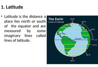
1. Latitude
• Latitudeis the distance a
place lies north or south
of the equator and are
measured by some
imaginary lines called
lines of latitude.
10.
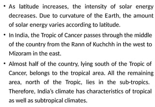
• As latitudeincreases, the intensity of solar energy
decreases. Due to curvature of the Earth, the amount
of solar energy varies according to latitude.
• In India, the Tropic of Cancer passes through the middle
of the country from the Rann of Kuchchh in the west to
Mizoram in the east.
• Almost half of the country, lying south of the Tropic of
Cancer, belongs to the tropical area. All the remaining
area, north of the Tropic, lies in the sub-tropics.
Therefore, India’s climate has characteristics of tropical
as well as subtropical climates.
11.
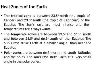
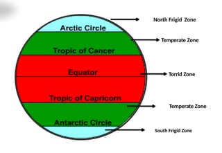
Heat Zones ofthe Earth
• The tropical zone is between 23.5o
north (the tropic of
Cancer) and 23.5o
south (the tropic of Capricorn) of the
Equator. The Sun’s rays are most intense and the
temperatures are always warm.
• The temperate zones are between 23.5o
and 66.5o
north
and between 23.5o
and 66.5o
south of the Equator. The
Sun’s rays strike Earth at a smaller angle than near the
Equator.
• Polar zones are between 66.5o
north and south latitudes
and the poles. The sun’s rays strike Earth at a very small
angle in the polar zones.
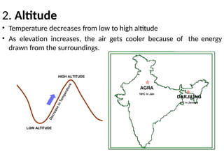
2. Altitude
• Temperaturedecreases from low to high altitude
• As elevation increases, the air gets cooler because of the energy
drawn from the surroundings.
DARJILING
40C in January
AGRA
160C in Jan
HIGH ALTITUDE
LOW ALTITUDE
14.
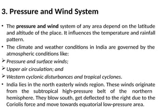
3. Pressure andWind System
• The pressure and wind system of any area depend on the latitude
and altitude of the place. It influences the temperature and rainfall
pattern.
• The climate and weather conditions in India are governed by the
atmospheric conditions like:
Pressure and surface winds;
Upper air circulation; and
Western cyclonic disturbances and tropical cyclones.
• India lies in the north easterly winds region. These winds originate
from the subtropical high-pressure belt of the northern
hemisphere. They blow south, get deflected to the right due to the
Coriolis force and move towards equatorial low-pressure area.
15.
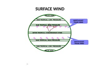
NORTH-EAST
TRADE WIND
SOUTH-EAST
TRADE WIND
INTERTROPICAL CONVERGENCE ZONE
SUB TROPICAL HIGH PRESSURE
SUB TROPICAL HIGH PRESSURE
SUB TROPICAL LOW PRESSURE
SUB TROPICAL LOW PRESSURE
POLAR HIGH
POLAR HIGH
15
SURFACE WIND
16.
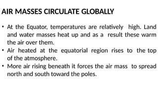
AIR MASSES CIRCULATEGLOBALLY
• At the Equator, temperatures are relatively high. Land
and water masses heat up and as a result these warm
the air over them.
• Air heated at the equatorial region rises to the top
of the atmosphere.
• More air rising beneath it forces the air mass to spread
north and south toward the poles.
17.
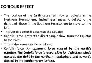
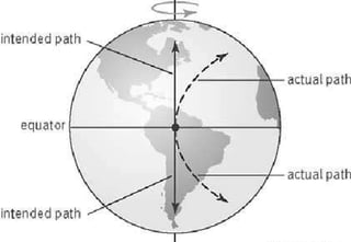
CORIOLIS EFFECT
• Therotation of the Earth causes all moving objects in the
Northern Hemisphere, including air mass, to deflect to the
right and those in the Southern Hemisphere to move to the
left.
• This Coriolis effect is absent at the Equator.
• Coriolis Force- prevents a direct simple flow from the Equator
to the Poles.
• This is also known as ‘Ferrel's Law’.
• Coriolis force: An apparent force caused by the earth’s
rotation. The Coriolis force is responsible for deflecting winds
towards the right in the northern hemisphere and towards
the left in the southern hemisphere.
19.
4. Distance fromthe Sea
• The sea exerts a moderating influence on climate:
As the distance from the sea increases, its
moderating influence decreases and the people
experience extreme weather conditions.
• This condition is known as continentality (i.e. very
hot during summers and very cold during winters).
• Coastal areas have equable climate where as
Interior parts have extreme climate.
20.
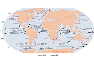
5. Ocean currents
•Ocean currents are the continuous, predictable,
directional movement of seawater driven by gravity, wind
(Coriolis Effect), and water density.
• Ocean currents are patterns of water movement that
influence climate zones and weather patterns around the
world.
• Ocean currents along with onshore winds affect the
climate of the coastal areas.
• For example, any coastal area with warm or cold currents
flowing past it, will be warmed or cooled if the winds are
onshore.
22.
6. Relief
• Highmountains act as barriers for cold or hot winds.
• They may also cause precipitation if they are high
enough and lie in the path of rain-bearing winds.
• The leeward side of mountains remains relatively dry.
1. Latitude
• TheTropic of Cancer passes through the middle of the
country from the Rann of Kuchchh in the west to
Mizoram in the east.
• Almost half of the country, lying south of the Tropic of
Cancer, belongs to the tropical area. All the remaining
area, north of the Tropic, lies in the sub-tropics.
• Therefore, India’s climate has characteristics of tropical
as well as subtropical climates.
25.
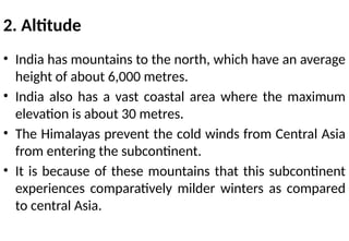
2. Altitude
• Indiahas mountains to the north, which have an average
height of about 6,000 metres.
• India also has a vast coastal area where the maximum
elevation is about 30 metres.
• The Himalayas prevent the cold winds from Central Asia
from entering the subcontinent.
• It is because of these mountains that this subcontinent
experiences comparatively milder winters as compared
to central Asia.
26.
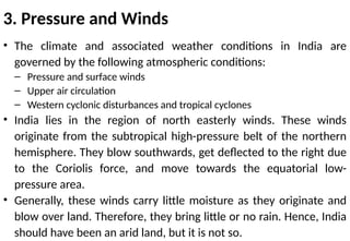
3. Pressure andWinds
• The climate and associated weather conditions in India are
governed by the following atmospheric conditions:
– Pressure and surface winds
– Upper air circulation
– Western cyclonic disturbances and tropical cyclones
• India lies in the region of north easterly winds. These winds
originate from the subtropical high-pressure belt of the northern
hemisphere. They blow southwards, get deflected to the right due
to the Coriolis force, and move towards the equatorial low-
pressure area.
• Generally, these winds carry little moisture as they originate and
blow over land. Therefore, they bring little or no rain. Hence, India
should have been an arid land, but it is not so.
27.
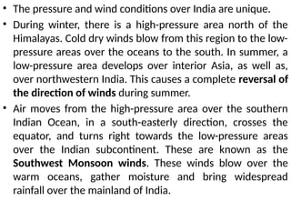
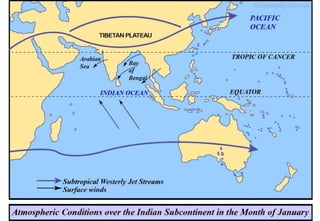
• The pressureand wind conditions over India are unique.
• During winter, there is a high-pressure area north of the
Himalayas. Cold dry winds blow from this region to the low-
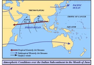
pressure areas over the oceans to the south. In summer, a
low-pressure area develops over interior Asia, as well as,
over northwestern India. This causes a complete reversal of
the direction of winds during summer.
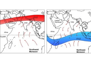
• Air moves from the high-pressure area over the southern
Indian Ocean, in a south-easterly direction, crosses the
equator, and turns right towards the low-pressure areas
over the Indian subcontinent. These are known as the
Southwest Monsoon winds. These winds blow over the
warm oceans, gather moisture and bring widespread
rainfall over the mainland of India.
28.
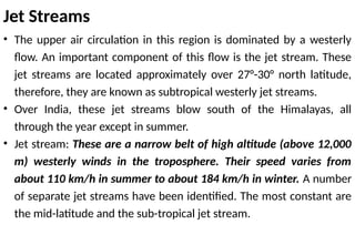
• The upperair circulation in this region is dominated by a westerly
flow. An important component of this flow is the jet stream. These
jet streams are located approximately over 27°-30° north latitude,
therefore, they are known as subtropical westerly jet streams.
• Over India, these jet streams blow south of the Himalayas, all
through the year except in summer.
• Jet stream: These are a narrow belt of high altitude (above 12,000
m) westerly winds in the troposphere. Their speed varies from
about 110 km/h in summer to about 184 km/h in winter. A number
of separate jet streams have been identified. The most constant are
the mid-latitude and the sub-tropical jet stream.
Jet Streams
31.
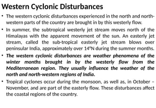
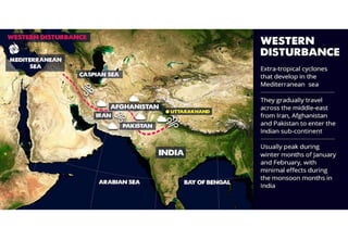
Western Cyclonic Disturbances
•The western cyclonic disturbances experienced in the north and north-
western parts of the country are brought in by this westerly flow.
• In summer, the subtropical westerly jet stream moves north of the
Himalayas with the apparent movement of the sun. An easterly jet
stream, called the sub-tropical easterly jet stream blows over
peninsular India, approximately over 14°N during the summer months.
• The western cyclonic disturbances are weather phenomena of the
winter months brought in by the westerly flow from the
Mediterranean region. They usually influence the weather of the
north and north-western regions of India.
• Tropical cyclones occur during the monsoon, as well as, in October –
November, and are part of the easterly flow. These disturbances affect
the coastal regions of the country.
• The climateof India is strongly influenced by monsoon
winds.
• The sailors who came to India in historic times were one
of the first to have noticed the phenomenon of the
monsoon.
• They benefited from the reversal of the wind system as
they came by sailing ships at the mercy of winds.
• The Arabs, who had also come to India as traders named
this seasonal reversal of the wind system ‘monsoon’.
35.
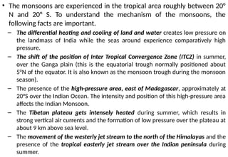
• The monsoonsare experienced in the tropical area roughly between 20°
N and 20° S. To understand the mechanism of the monsoons, the
following facts are important.
– The differential heating and cooling of land and water creates low pressure on
the landmass of India while the seas around experience comparatively high
pressure.
– The shift of the position of Inter Tropical Convergence Zone (ITCZ) in summer,
over the Ganga plain (this is the equatorial trough normally positioned about
5°N of the equator. It is also known as the monsoon trough during the monsoon
season).
– The presence of the high-pressure area, east of Madagascar, approximately at
20°S over the Indian Ocean. The intensity and position of this high-pressure area
affects the Indian Monsoon.
– The Tibetan plateau gets intensely heated during summer, which results in
strong vertical air currents and the formation of low pressure over the plateau at
about 9 km above sea level.
– The movement of the westerly jet stream to the north of the Himalayas and the
presence of the tropical easterly jet stream over the Indian peninsula during
summer.
36.
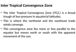
Inter Tropical ConvergenceZone
• The Inter Tropical Convergence Zone (ITCZ,) is a broad
trough of low pressure in equatorial latitudes.
• This is where the northeast and the southeast trade
winds converge.
• This convergence zone lies more or less parallel to the
equator but moves north or south with the apparent
movement of the sun.
38.
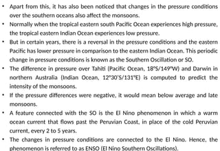
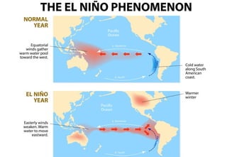
• Apart fromthis, it has also been noticed that changes in the pressure conditions
over the southern oceans also affect the monsoons.
• Normally when the tropical eastern south Pacific Ocean experiences high pressure,
the tropical eastern Indian Ocean experiences low pressure.
• But in certain years, there is a reversal in the pressure conditions and the eastern
Pacific has lower pressure in comparison to the eastern Indian Ocean. This periodic
change in pressure conditions is known as the Southern Oscillation or SO.
• The difference in pressure over Tahiti (Pacific Ocean, 18°S/149°W) and Darwin in
northern Australia (Indian Ocean, 12°30’S/131°E) is computed to predict the
intensity of the monsoons.
• If the pressure differences were negative, it would mean below average and late
monsoons.
• A feature connected with the SO is the El Nino phenomenon in which a warm
ocean current that flows past the Peruvian Coast, in place of the cold Peruvian
current, every 2 to 5 years.
• The changes in pressure conditions are connected to the El Nino. Hence, the
phenomenon is referred to as ENSO (El Nino Southern Oscillations).
39.
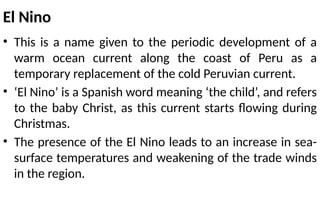
El Nino
• Thisis a name given to the periodic development of a
warm ocean current along the coast of Peru as a
temporary replacement of the cold Peruvian current.
• ‘El Nino’ is a Spanish word meaning ‘the child’, and refers
to the baby Christ, as this current starts flowing during
Christmas.
• The presence of the El Nino leads to an increase in sea-
surface temperatures and weakening of the trade winds
in the region.
41.
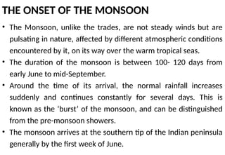
THE ONSET OFTHE MONSOON
• The Monsoon, unlike the trades, are not steady winds but are
pulsating in nature, affected by different atmospheric conditions
encountered by it, on its way over the warm tropical seas.
• The duration of the monsoon is between 100- 120 days from
early June to mid-September.
• Around the time of its arrival, the normal rainfall increases
suddenly and continues constantly for several days. This is
known as the ‘burst’ of the monsoon, and can be distinguished
from the pre-monsoon showers.
• The monsoon arrives at the southern tip of the Indian peninsula
generally by the first week of June.
42.
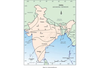
• Subsequently, itproceeds into two – the Arabian Sea branch and the Bay of
Bengal branch.
• The Arabian Sea branch reaches Mumbai about ten days later on
approximately the 10th of June. This is a fairly rapid advance. The Bay of Bengal
branch also advances rapidly and arrives in Assam in the first week of June.
• The lofty mountains causes the monsoon winds to deflect towards the west
over the Ganga plains. By mid-June the Arabian Sea branch of the monsoon
arrives over Saurashtra-Kuchchh and the central part of the country.
• The Arabian Sea and the Bay of Bengal branches of the monsoon merge over
the northwestern part of the Ganga plains. Delhi generally receives the
monsoon showers from the Bay of Bengal branch by the end of June (tentative
date is 29th of June).
• By the first week of July, western Uttar Pradesh, Punjab, Haryana and eastern
Rajasthan experience the monsoon. By mid-July, the monsoon reaches
Himachal Pradesh and the rest of the country.
44.
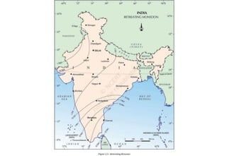
WITHDRAWAL OF THEMONSOON
• Withdrawal or the retreat of the monsoon is a more gradual process.
• The withdrawal of the monsoon begins in north-western states of India
by early September.
• By mid-October, it withdraws completely from the northern half of the
peninsula. The withdrawal from the southern half of the peninsula is
fairly rapid.
• By early December, the monsoon has withdrawn from the rest of the
country.
• The islands receive the very first monsoon showers, progressively from
south to north, from the last week of April to the first week of May.
• The withdrawal, takes place progressively from north to south from the
first week of December to the first week of January. By this time the
rest of the country is already under the influence of the winter
monsoon.
The Seasons
• Themonsoon type of climate is characterised by a distinct
seasonal pattern.
• The weather conditions greatly change from one season to
the other.
• Noticeable in the interior parts of the country
• The coastal areas do not experience much variation in
temperature though there is variation in rainfall pattern.
• Four main seasons can be identified in India
– the cold weather season
– the hot weather season
– the advancing monsoon
– the retreating monsoon
• From mid-Novemberin northern India and stays till February.
• December and January are the coldest months in the northern part of
India.
• The temperature decreases from south to the north.
• The average temperature of Chennai, on the eastern coast, is between 24°
– 25° Celsius, while in the northern plains, it ranges between 10°C and 15°
Celsius.
• Days are warm and nights are cold.
• Frost is common in the north and the higher slopes of the Himalayas
experience snowfall.
• During this season, the northeast trade winds prevail over the country. They
blow from land to sea and hence, for most part of the country, it is a dry
season. Some amount of rainfall occurs on the Tamil Nadu coast from these
winds as, here they blow from sea to land.
• In the northern part of the country, a feeble high-pressure region develops,
with light winds moving outwards from this area.
• Influenced by the relief, these winds blow through the Ganga valley from
50.
• The weatheris normally marked by clear sky, low temperatures and
low humidity and feeble, variable winds.
• A characteristic feature of the cold weather season over the northern
plains is the inflow of cyclonic disturbances from the west and the
northwest.
• These low-pressure systems, originate over the Mediterranean Sea
and western Asia and move into India, along with the westerly flow.
• They cause the much-needed winter rains over the plains and
snowfall in the mountains.
• Although the total amount of winter rainfall locally known as
‘mahawat’ is small, they are of immense importance for the
cultivation of ‘rabi’ crops.
• The peninsular region does not have a well defined cold season.There
is hardly any noticeable seasonal change in temperature pattern
during winters due to the moderating influence of the sea.
• Due tothe apparent northward movement of the sun, the global heat
belt shifts northwards.
• From March to May, it is hot weather season in India.
• The influence of the shifting of the heat belt can be seen clearly from
temperature recordings taken during March-May at different latitudes.
• In March, the highest temperature is about 38° Celsius, recorded on
the Deccan plateau. In April, temperatures in Gujarat and Madhya
Pradesh are around 42° Celsius. In May, temperature of 45° Celsius is
common in the north-western parts of the country.
• In peninsular India, temperatures remain lower due to the moderating
influence of the oceans.
• The summer months experience rising temperature and falling air
pressure in the northern part of the country.
• Towards the end of May, an elongated low-pressure area develops in
the region extending from the Thar Desert in the northwest to Patna
and Chotanagpur plateau in the east and southeast.
• Circulation of air begins to set in around this trough.
53.
• A strikingfeature of the hot weather season is the ‘loo’.
– These are strong, gusty, hot, dry winds blowing during the day
over the north and north-western India. Sometimes they even
continue until late in the evening. Direct exposure to these
winds may even prove to be fatal.
• Dust storms are very common during the month of May in
northern India. These storms bring temporary relief as they lower
the temperature and may bring light rain and cool breeze.
• This is also the season for localised thunderstorms, associated
with violent winds, torrential downpours, often accompanied by
hail. In West Bengal, these storms are known as the ‘Kaal Baisakhi’.
• Towards the close of the summer season, pre-monsoon showers
are common especially, in Kerala and Karnataka. They help in the
early ripening of mangoes, and are often referred to as ‘mango
showers’.
• By earlyJune, the low-pressure condition over the northern plains intensifies. It attracts,
the trade winds of the southern hemisphere.
• These south-east trade winds originate over the warm subtropical areas of the southern
oceans.
• They cross the equator and blow in a south westerly direction entering the Indian
peninsula as the south-west monsoon.
• As these winds blow over warm oceans, they bring abundant moisture to the
subcontinent. These winds are strong and blow at an average velocity of 30 km per hour.
• With the exception of the extreme north-west, the monsoon winds cover the country in
about a month.
• The inflow of the south-west monsoon into India brings about a total change in the
weather.
• Early in the season, the windward side of the Western Ghats receives very heavy rainfall,
more than 250 cm.
• The Deccan Plateau and parts of Madhya Pradesh also receive some amount of rain in
spite of lying in the rain shadow area.
• The maximum rainfall of this season is received in the north-eastern part of the country.
• Mawsynram in the southern ranges of the Khasi Hills receives the highest average
rainfall in the world.
• Rainfall in the Ganga valley decreases from the east to the west.
• Rajasthan and parts of Gujarat get scanty rainfall.
56.
• Another phenomenonassociated with the monsoon is its tendency to have ‘breaks’ in
rainfall.
• Thus, it has wet and dry spells. In other words, the monsoon rains take place only for a few
days at a time. They are interspersed with rainless intervals.
• These breaks in monsoon are related to the movement of the monsoon trough. For various
reasons, the trough and its axis keep on moving northward or southward, which determines
the spatial distribution of rainfall. When the axis of the monsoon trough lies over the plains,
rainfall is good in these parts. On the other hand, whenever the axis shifts closer to the
Himalayas, there are longer dry spells in the plains, and widespread rain occur in the
mountainous catchment areas of the Himalayan rivers. These heavy rains bring in their
wake, devastating floods causing damage to life and property in the plains.
• The frequency and intensity of tropical depressions too, determine the amount and
duration of monsoon rains. These depressions form at the head of the Bay of Bengal and
cross over to the mainland. The depressions follow the axis of the “monsoon trough of low
pressure”. The monsoon is known for its uncertainties. The alternation of dry and wet spells
vary in intensity, frequency and duration. While it causes heavy floods in one part, it may be
responsible for droughts in the other. It is often irregular in its arrival and its retreat. Hence,
it sometimes disturbs the farming schedule of millions of farmers all over the country.
• During October-November,with the apparent movement of the sun towards the
south, the monsoon trough or the low-pressure trough over the northern plains
becomes weaker. This is gradually replaced by a high-pressure system.
• The south-west monsoon winds weaken and start withdrawing gradually. By the
beginning of October, the monsoon withdraws from the Northern Plains.
• The months of October-November form a period of transition from hot rainy
season to dry winter conditions.
• The retreat of the monsoon is marked by clear skies and rise in temperature.
While day temperatures are high, nights are cool and pleasant.
• The land is still moist. Owing to the conditions of high temperature and
humidity, the weather becomes rather oppressive during the day. This is
commonly known as ‘October heat’.
• In the second half of October, the mercury begins to fall rapidly in northern
India.
59.
• The low-pressureconditions, over north-western India,
get transferred to the Bay of Bengal by early November.
• This shift is associated with the occurrence of cyclonic
depressions, which originate over the Andaman Sea.
• These cyclones generally cross the eastern coasts of India
cause heavy and widespread rain.
• These tropical cyclones are often very destructive.
• The thickly populated deltas of the Godavari, the Krishna
and the Kaveri are frequently struck by cyclones, which
cause great damage to life and property.
• Sometimes, these cyclones arrive at the coasts of Odisha,
West Bengal and Bangladesh.
• The bulk of the rainfall of the Coromandel Coast is
derived from depressions and cyclones.
60.
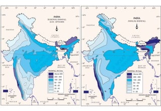
Distribution of Rainfall
•Parts of western coast and north-eastern India receive over about 400 cm of rainfall
annually.
• However, it is less than 60 cm in western Rajasthan and adjoining parts of Gujarat,
Haryana and Punjab.
• Rainfall is equally low in the interior of the Deccan plateau, and east of the Sahyadris.
• A third area of low precipitation is around Leh in Jammu and Kashmir.
• The rest of the country receives moderate rainfall.
• Snowfall is restricted to the Himalayan region.
• Owing to the nature of monsoons, the annual rainfall is highly variable from year to
year.
• Variability is high in the regions of low rainfall, such as parts of Rajasthan, Gujarat
and the leeward side of the Western Ghats.
• As such, while areas of high rainfall are liable to be affected by floods, areas of low
rainfall are drought-prone.
62.
Monsoon as aunifying bond
• The Himalayas protect the subcontinent from extremely
cold winds from central Asia.
• This enables northern India to have uniformly higher
temperatures compared to other areas on the same
latitudes.
• Similarly, the Peninsular plateau, under the influence of
the sea from three sides, has moderate temperatures.
• Despite such moderating influences, there are great
variations in the temperature conditions.
• The unifying influence of the monsoon on the Indian
subcontinent is quite perceptible.
63.
• The seasonalalteration of the wind systems and the
associated weather conditions provide a rhythmic cycle of
seasons.
• Even the uncertainties of rain and uneven distribution are
very much typical of the monsoons.
• The Indian landscape, its animal and plant life, its entire
agricultural calendar and the life of the people, including
their festivities, revolve around this phenomenon.
• Year after year, people of India from north to south and from
east to west, eagerly await the arrival of the monsoon.
• These monsoon winds bind the whole country by providing
water to set the agricultural activities in motion.
• The river valleys which carry this water also unite as a single
river valley unit.


![CLASS9 CLIMATE PPT MY VERSION ( FOR ONLINE CLASS [Autosaved].pptx](https://cdn.slidesharecdn.com/ss_thumbnails/class9climatepptmyversionforonlineclassautosaved-250804164803-907f39e5-thumbnail.jpg?width=640&height=640&fit=bounds)


