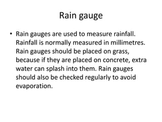
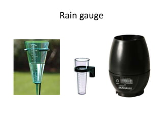
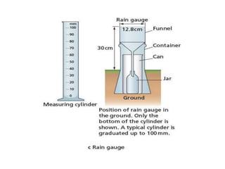
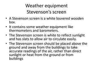
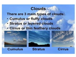
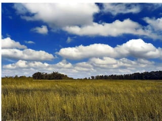
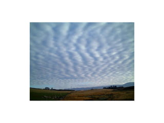
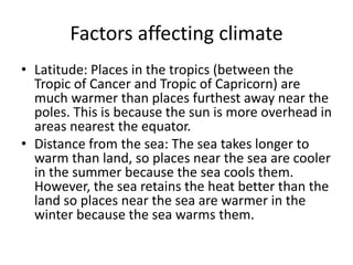
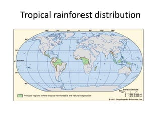
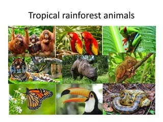
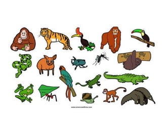
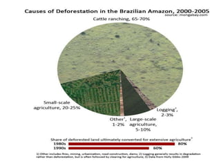
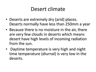
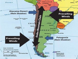
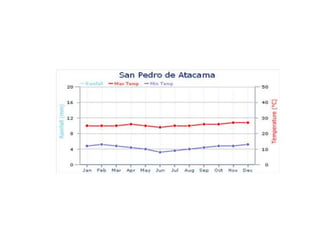
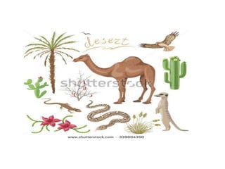
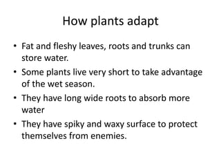
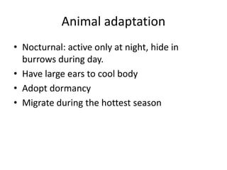
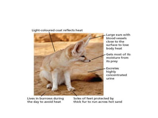
Weather refers to short-term atmospheric conditions while climate describes average weather patterns over longer periods of time. Various instruments are used to measure and monitor weather elements like temperature, pressure, humidity, wind, and precipitation. Climate is influenced by factors such as latitude, distance from bodies of water, prevailing winds, ocean currents, altitude, and cloud cover. Tropical rainforests and deserts have unique climates that shape distinctive plant and animal adaptations for survival. Deforestation threatens rainforests and contributes to desertification.
GEOGRAPHY IGCSE: WEATHER MEASUREMENTS. It contains: difference between weather and climate, measuring the weather, what do we measure, temperature, precipitation, wind direction, Beaufort scale, cloud cover, air pressure, glossary.
CAMBRIDGE AS GEOGRAPHY REVISION: HYDROLOGY AND FLUVIAL GEOMORPHOLOGY - 1.1 DR...George Dumitrache
A presentation of the first subchapter (Drainage Basin Systems) from the first chapter (Hydrology and Fluvial Geomorphology) of Revision for Geography AS Cambridge exam.
AS Level Physical Geography - Hydrology and Fluvial GeomorphologyArm Punyathorn
Water is an agent of change in the atmosphere, geosphere and biosphere. In this chapter we will try to understand the passage of water as it changes states.We will also look at how the forces of river can shape land forms as well as civilization
CAMBRIDGE GEOGRAPHY A2 REVISION - PRODUCTION, LOCATION AND CHANGE: 11.3 MANUFACTURING AND RELATED SERVICE INDUSTRY. It contains: key terms and definitions, topic summary, additional work and suggested websites.
Geography notes Hydrology, Atmosphere, Weathering, Population and Migration
Casestudies aren't included - sorry. Hope these are helpful. Good luck everyone with your exams.
A comprehensive presentation about population, for the AS level, using all the important definitions necessary for the exam: distribution and density, population changes, population structure, models, trends in population growth, optimum, over and under population, theories relating to world population and food supply and the demographic transition model. Case studies: Kenya, USA, Denmark, China.
AS Level Physical Geography - Atmosphere and WeatherArm Punyathorn
Weather influences every part of our daily life. Climate shapes our culture, our history and our civilization. The changes in wind, temperature, humidity can not be underestimated.
AS Level Human Geography - Migration of Population Arm Punyathorn
This chapter has very recently been expanded from being a mere part of the population dynamic topic. A good call since migration has become a pretty big issue in the world today as population mobility has greatly increased in the 21st century.
CAMBRIDGE GEOGRAPHY AS - HYDROLOGY AND FLUVIAL GEOMORPHOLOGY; 1.1. DRAINAGE B...George Dumitrache
Introductory presentation of the drainage basin systems in the first chapter of Hydrology and Fluvial Geomorphology, suitable for AS students, consisting in the following: the global hydrological cycle, store, flows, the drainage systems, precipitation, evapotranspiration, interception, infiltration, percolation, drainage patterns, the water balance.
CAMBRIDGE GEOGRAPHY AS - HYDROLOGY AND FLUVIAL GEOMORPHOLOGY: 1.3 RIVER CHANN...George Dumitrache
Subchapter 3 in the first chapter of Hydrology and Fluvial Geomorphology, suitable for AS students, consisting in the following: river processes, velocity, flows and Hjulstrom Curve.
A2 CAMBRIDGE GEOGRAPHY: COASTAL ENVIRONMENTS - CORAL REEFS. It contains: what are coral reefs, the development of corals, growth rates, polyps and algae, reef formation, fringing reefs, barrier reefs, atolls, threats to coral.
CAMBRIDGE AS GEOGRAPHY REVISION: ATMOSPHERE AND WEATHER - 2.3 WEATHER PROCESS...George Dumitrache
A comprehensive presentation of subchapter 2.3 Weather Processes and Phenomena, from the second chapter of Physical Geography, AS Cambridge, Atmosphere and Weather.
Flowing water has the ability to dissolve the soluble mineral substances available on its way. The processes enacted by streams are called as fluvial processes. The word “fluvius” is derived from the latin word meaning “ river”. The world fluvial is used to denote the running water as streams or rivers. Fluvial processes entail the erosion, transportation, and deposition of earth materials by running water. Fluvial processes and fluvial landforms dominate land surfaces the world over, as opposed to the limited effects of glacial, coastal, and wind processes.
Effect of Precipatation on Distribution of Plants.pptxCHZaryabAli
Useful for the students who wants to study this topic & enhances the knowledge for a specific topic.
PRECIPITATION:
is any product of the condensation of atmospheric water that falls under gravity from clouds.
The main forms of precipitation include drizzle, rain, sleet, snow, ice pellets, graupel and hail. Precipitation occurs when a portion of the atmosphere becomes saturated with water vapor (reaching 100% relative humidity), so that the water condenses and "precipitates". Thus, fog and mist are not precipitation but suspensions, because the water vapor does not condense sufficiently to precipitate.
Two processes, possibly acting together, can lead to air becoming saturated: cooling the air or adding water vapor to the air.
REASON FOR CHANGE IN PRECIPITATION:There are many reasons for changes in precipitation. The leading cause is a change in temperature. Many scientists believe an increase in temperature could lead to a more intense water cycle. The rates of evaporation from soils and water, as well as transpiration from plants, could increase. The amount of precipitation could also increase. Predicted changes in the water cycle differ according to the region of the planet being examined. Many scientists believe rates of evaporation will be greater than precipitation in the middle latitudes such as the United States. This could result in drier summers in these regions. Of course, predicted changes in the water cycle also differ according to the climate.EFFECT OF PRECIPITATION ON PLANTS:Precipitation, especially rain, has a dramatic effect on plants distribution. All plants need at least some water to survive, therefore rain (being the most effective means of watering) is important to agriculture. While a regular rain pattern is usually vital to healthy plants, too much or too little rainfall can be harmful, even devastating to crops. Drought can kill crops and increase erosion, while overly wet weather can cause harmful fungus growth. Plants need varying amounts of rainfall to survive. For example, certain cacti require small amounts of water, while tropical plants may need up to hundreds of inches of rain per year to survive.In areas with wet and dry seasons, soil nutrients diminish and erosion increases during the wet season.
DISTRIBUTION OF PLANTS IN DIFFERENT BIOMES:The geographical distribution (and productivity) of the plants in the various biomes is controlled primarily by the climatic variables precipitation and temperature. There are 8 major terrestrial biomes >Tropical Rain Forest >Tropical Savanna > Deserts >Grass Lands > Chaparral > Temperate Deciduous Forests > Temperate Boreal Forests > Artic And Alpine TundraEach biome plants have different adaptation to survive in that environment.
Tundra means marshy plain. The geographical distribution of the tundra biome is largely poleward of 60° North latitude.
The tundra biome is characterized by an absence of trees, the presence of dwarf plants
Unit 8 - Information and Communication Technology (Paper I).pdfThiyagu K
This slides describes the basic concepts of ICT, basics of Email, Emerging Technology and Digital Initiatives in Education. This presentations aligns with the UGC Paper I syllabus.
June 3, 2024 Anti-Semitism Letter Sent to MIT President Kornbluth and MIT Cor...Levi Shapiro
Letter from the Congress of the United States regarding Anti-Semitism sent June 3rd to MIT President Sally Kornbluth, MIT Corp Chair, Mark Gorenberg
Dear Dr. Kornbluth and Mr. Gorenberg,
The US House of Representatives is deeply concerned by ongoing and pervasive acts of antisemitic
harassment and intimidation at the Massachusetts Institute of Technology (MIT). Failing to act decisively to ensure a safe learning environment for all students would be a grave dereliction of your responsibilities as President of MIT and Chair of the MIT Corporation.
This Congress will not stand idly by and allow an environment hostile to Jewish students to persist. The House believes that your institution is in violation of Title VI of the Civil Rights Act, and the inability or
unwillingness to rectify this violation through action requires accountability.
Postsecondary education is a unique opportunity for students to learn and have their ideas and beliefs challenged. However, universities receiving hundreds of millions of federal funds annually have denied
students that opportunity and have been hijacked to become venues for the promotion of terrorism, antisemitic harassment and intimidation, unlawful encampments, and in some cases, assaults and riots.
The House of Representatives will not countenance the use of federal funds to indoctrinate students into hateful, antisemitic, anti-American supporters of terrorism. Investigations into campus antisemitism by the Committee on Education and the Workforce and the Committee on Ways and Means have been expanded into a Congress-wide probe across all relevant jurisdictions to address this national crisis. The undersigned Committees will conduct oversight into the use of federal funds at MIT and its learning environment under authorities granted to each Committee.
• The Committee on Education and the Workforce has been investigating your institution since December 7, 2023. The Committee has broad jurisdiction over postsecondary education, including its compliance with Title VI of the Civil Rights Act, campus safety concerns over disruptions to the learning environment, and the awarding of federal student aid under the Higher Education Act.
• The Committee on Oversight and Accountability is investigating the sources of funding and other support flowing to groups espousing pro-Hamas propaganda and engaged in antisemitic harassment and intimidation of students. The Committee on Oversight and Accountability is the principal oversight committee of the US House of Representatives and has broad authority to investigate “any matter” at “any time” under House Rule X.
• The Committee on Ways and Means has been investigating several universities since November 15, 2023, when the Committee held a hearing entitled From Ivory Towers to Dark Corners: Investigating the Nexus Between Antisemitism, Tax-Exempt Universities, and Terror Financing. The Committee followed the hearing with letters to those institutions on January 10, 202
Operation “Blue Star” is the only event in the history of Independent India where the state went into war with its own people. Even after about 40 years it is not clear if it was culmination of states anger over people of the region, a political game of power or start of dictatorial chapter in the democratic setup.
The people of Punjab felt alienated from main stream due to denial of their just demands during a long democratic struggle since independence. As it happen all over the word, it led to militant struggle with great loss of lives of military, police and civilian personnel. Killing of Indira Gandhi and massacre of innocent Sikhs in Delhi and other India cities was also associated with this movement.
Introduction to AI for Nonprofits with Tapp NetworkTechSoup
Dive into the world of AI! Experts Jon Hill and Tareq Monaur will guide you through AI's role in enhancing nonprofit websites and basic marketing strategies, making it easy to understand and apply.
Read| The latest issue of The Challenger is here! We are thrilled to announce that our school paper has qualified for the NATIONAL SCHOOLS PRESS CONFERENCE (NSPC) 2024. Thank you for your unwavering support and trust. Dive into the stories that made us stand out!
Honest Reviews of Tim Han LMA Course Program.pptxtimhan337
Personal development courses are widely available today, with each one promising life-changing outcomes. Tim Han’s Life Mastery Achievers (LMA) Course has drawn a lot of interest. In addition to offering my frank assessment of Success Insider’s LMA Course, this piece examines the course’s effects via a variety of Tim Han LMA course reviews and Success Insider comments.
Macroeconomics- Movie Location
This will be used as part of your Personal Professional Portfolio once graded.
Objective:
Prepare a presentation or a paper using research, basic comparative analysis, data organization and application of economic information. You will make an informed assessment of an economic climate outside of the United States to accomplish an entertainment industry objective.
2. Weather and Climate
• Weather is the current state of the
atmosphere (rain, temperature, wind, cloud
cover, humidity etc)
• Climate is the condition of the atmosphere in
a region over a period of time (year)
3.
4.
5. Weather equipment
Stevenson’s screen
• A Stevenson screen is a white louvered wooden
box.
• It contains some weather equipment like
thermometers and barometers.
• The Stevenson screen is white to reflect sunlight
and has slats to allow air to circulate easily.
• The Stevenson screen should be placed above the
ground and away from the buildings to take
accurate readings of the air, rather than direct
sunlight or heat from the ground or from
buildings
7. Barometer
• Barometers are used to measure air pressure
(in millibars).
• Barometers are normally kept inside
Stevenson screens to keep them safe.
• A barometer has a movable needle (pointer)
which can be moved to the current reading so
that you can then make a comparison with the
reading from the following day.
9. Max./Min. Thermometer or Six’s
Thermometer
• A maximum and minimum thermometer
records the maximum temperature of the day
and the minimum temperature of the day
(diurnal range).
13. • A hygrometer measures the humidity of the air.
Humidity is the amount of moisture (water
vapour) in the air.
• A hygrometer has two thermometers, a dry one
and a wet.
• Humidity is measured by using a table that looks
at the difference between the wet bulb and the
dry bulb.
• A hygrometer can also be used to find dew point.
19. • Anemometers measure wind speed.
• Wind speed is normally measured in mph or
kph, but can also be measured in m/s (metres
a second).
• Digital anemometers are more accurate.
• Anemometers are normally placed on top of
buildings so that they are not protected from
the wind and so they don't experience
channeling of wind
20. Rain gauge
• Rain gauges are used to measure rainfall.
Rainfall is normally measured in millimetres.
Rain gauges should be placed on grass,
because if they are placed on concrete, extra
water can splash into them. Rain gauges
should also be checked regularly to avoid
evaporation.
24. Wind vane
• Wind vanes are used to check the direction of the
wind.
• Compass points are used to give wind direction.
• Wind is measured in the direction that the wind
is coming from.
• Wind vanes are often placed on top of buildings
so that they are fully exposed to the wind.
• When using a wind vane you need to use a
compass to make sure that it is properly aligned.
25. Cloud cover
• Cloud cover (also known as cloudiness,
cloudage, or cloud amount) refers to the
fraction of the sky obscured by clouds when
observed from a particular location. Okta is
the usual unit of measurement of the cloud
cover.
• This is made by a visual assessment of how
much of the sky is covered by cloud.
28. • To calculate cloud cover a mirror is often used.
• You divide the mirror into squares and then
place the mirror on the ground.
• The mirror will reflect the clouds and you can
count the number of squares covered or
partially covered by cloud.
• You can do this as a percentage or convert to
oktas which is the normal measurement of
cloud cover.
29. Sunshine recorder
• A sunshine recorder is a device that records the
amount of sunshine at a given location. The
results provide information about the weather
and climate as well as the temperature of a
geographical area.
• Sunshine recorder consists of a glass sphere
mounted in a spherical bowl and a metallic
groove which holds a record card. Sun's rays are
refracted and focused sharply on the record card
beneath the glass sphere, leaving burnt marks on
the card.
30.
31.
32. Explain the uses of the following
equipment
1. Stevenson screen
2. Barometer
3. Max/Min Thermometer
4. Wet/ Dry bulb thermometer
5. Anemometer
6. Rain gauge
7. Wind vane
8. Sunshine recorder
61. Factors affecting climate
• Latitude: Places in the tropics (between the
Tropic of Cancer and Tropic of Capricorn) are
much warmer than places furthest away near the
poles. This is because the sun is more overhead in
areas nearest the equator.
• Distance from the sea: The sea takes longer to
warm than land, so places near the sea are cooler
in the summer because the sea cools them.
However, the sea retains the heat better than the
land so places near the sea are warmer in the
winter because the sea warms them.
62. • Prevailing winds: If the prevailing wind is from
the poles then the temperature will be lower,
but if the prevailing wind is from the tropics
then the temperature will be higher.
• Ocean currents Hot ocean currents tends to
warm winters and cold ones cool summers.
The UK benefits from a warm ocean current
travelling from the Gulf of Mexico.
63. • Altitude: Temperatures on average decrease 1
degree Celsius for every 100 meters gained.
This means that some places near the Equator
e.g. the Andes in Ecuador can be covered in
snow all year.
• Cloud cover: high cloud cover reduces
temperature and low cloud cover increases.
67. • Emergents: Emergents are tall trees that grow
above the canopy
• Canopy: The canopy layer contains about 50%
of the rainforests wildlife.
• Shrub Layer: The shrub layer is near the forest
floor and is also extremely dense.
68.
69. Importance of tropical rainforests
• Biodiversity: contain 50% of flora and fauna
• Photosynthesis: they are the lungs of the
earth
• Prevents soil erosion and flood
• Economic value: provides wood, medicines,
food.
• Habitat for indigenous people.
• Controls climate
70. Reasons for rainforest deforestation
• Subsistence farming and farming techniques
• Hydro electric projects
• Mining
• Cattle ranching
• Population growth
• Tourism
• Illegal logging
71. Problems of deforestation
• Flooding
• Landslides
• Biodiversity lost
• Silting of rivers, seas and oceans
• Desertification
• Reduced rainfall
• Climate change
74. Protecting rainforests
• Creation of national parks
• Sustainable forestry
• Promoting ecotourism
• Ban the sale of rain forest products
• Educating people about the ill effects
•
76. Amazon rainforest facts:
• It is home to 1000 species of bird and 60,000
species of plants
• 10 million species of insects live in the Amazon
• It is home to 20 million people, who use the
wood, cut down trees for farms and for cattle.
• It covers 2.1 million square miles of land
• The Amazon is home to almost 20% of species on
Earth
• The UK and Ireland would fit into the Amazon 17
times!
77. Deforestation in Amazon
• An area of rainforest the size of Belgium was
being cut down every year.
• Brazil has over 60% of Amazon rain forests.
• Cattle ranching, agriculture (both small scale
and large scale), and logging are major
reasons.
• If no action taken, at current rate of
deforestation, the Amazon rainforest would be
reduced by 40% in two decades.
78.
79. Desert climate
• Deserts are extremely dry (arid) places.
Deserts normally have less than 250mm a year
• Because there is no moisture in the air, there
are very few clouds in deserts which means
desert have high levels of incoming radiation
from the sun.
• Daytime temperature is very high and night
time temperature (diurnal) is very low in the
deserts.
85. How plants adapt
• Fat and fleshy leaves, roots and trunks can
store water.
• Some plants live very short to take advantage
of the wet season.
• They have long wide roots to absorb more
water
• They have spiky and waxy surface to protect
themselves from enemies.
86. Animal adaptation
• Nocturnal: active only at night, hide in
burrows during day.
• Have large ears to cool body
• Adopt dormancy
• Migrate during the hottest season
87.
88. Case Study: An area of hot desert
• The Sahel region – Desertification
89. The Sahel
• The Sahel is an area of land south of the Sahara,
running from Mauritania in the west, through
Niger, Burkina Faso, Mali, Chad, Sudan and across
to Ethiopian in the west.
• The vegetation is mainly savanna (grassland) with
some areas of woodland and shrub land and
people are traditional semi-nomadic herders.
• In recent years the Sahel has been suffering from
increasing soil degradation and desertification.
90. Reason for soil degradation and
desertification
• Population Growth (the population of the region
is doubling in every 20 years)
• Deforestation (much of it caused by people
collecting firewood)
• Overgrazing: Nomadic herders keep cattles
• Rising temperatures (greater evaporation) and
reduced rainfall (droughts)
• Storms - the rainfall that does take place tends to
be in shorter more intense storms that can lead
to water erosion.
91. Problems of desertification
• Famine, shortage of food, water and other
resources
• Dust storms
• Conflict over diminishing resources
92. Solutions to desertification
• Build green wall – planting trees in deserts to
stop the spread of deserts.
• Reforestation (planting trees in deforested areas)
and afforestation (planting in new areas)
• Irrigation
• Population control to reduce pressure on
resources.
• Introduce GM (Genetically modified) crops that
can withstand dry, poor soil.
93. Tropical storms
• Hurricanes (typhoons or cyclones) are the
most violent storms on Earth.
• The scientific term for all these storms is
tropical cyclone.
• Only tropical cyclones that form over the
Atlantic Ocean or eastern Pacific Ocean are
called "hurricanes."
94.
95. • Tropical cyclones are like giant engines that
use warm, moist air as fuel. That is why they
form only over warm ocean waters near the
equator.
• The warm, moist air over the ocean rises
upward from near the surface, causing an area
of lower air pressure below.
96. • Air from surrounding areas with higher air
pressure pushes in to the low pressure area.
Then that "new" air becomes warm and moist
and rises, too. As the warm air continues to
rise, the surrounding air swirls in to take its
place. As the warmed, moist air rises and
cools off, the water in the air forms clouds.
The whole system of clouds and wind spins
and grows, fed by the ocean's heat and water
evaporating from the surface.
97. • As the storm system rotates faster and faster,
an eye forms in the center. It is very calm and
clear in the eye, with very low air pressure.
Higher pressure air from above flows down
into the eye.