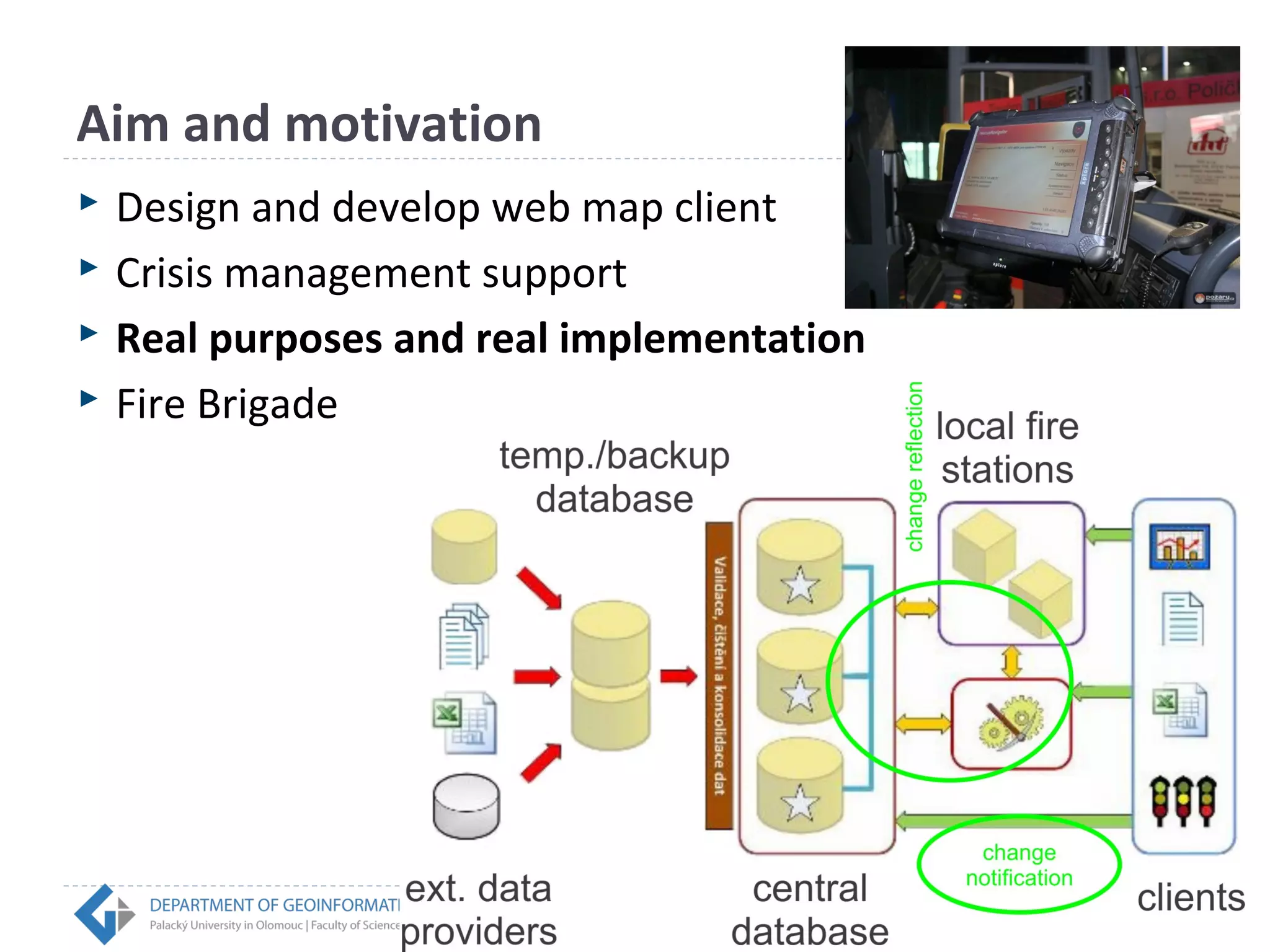
On-screen Editing of Map Content via Web 
Browser in Real Time 
Rostislav NÉTEK 
InDOG, Olomouc | 14/10/2014
Aim and motivation 
 Design and develop web map client 
 Crisis management support 
 Real purposes and real implementation 
 Fire Brigade
Web 2.0 + WebGIS 
MAIRO I. (2013) WebGIS 2.0 principles and overview. 
http://italomairo.italomairo.com/en/content/gis-web-gis-20-principles-and-overview. 
Rich Internet Application 
+ 
Service-oriented Architecture 
WebGIS 2.0
Rich Internet Application 
 New generation of internet application 
 General concept, not concrete technology 
 AJAX, Silverlight, Openlaszlo, JavaFX, Flex, HTML5 
 Brings the tools, practices and conventions from desktop 
platform 
 Fully web application 
 Esthetical features 
RIA characteristics (+) 
 Run in the Web browser (both online and offline) 
 Combine properties from desktop applications into Web interface 
 No installation process required 
 Immediate feedback, refresh is not required 
 Rich content (video, sound, animation, vectors, drag and drop, 
keyboard navigation, ...) 
 Platform independent 
 Faster processing of requests 
 Rich user interface 
 Focus on esthetical impression 
 Easy distribution and start-up 
 Mobile applications are fully supported and available 
 Open source 
 Wide possibility of customization
RIA characteristics (-)
 Adobe/Apache Flex 
 GIS ® Flex 
 Runs in the same environment like Flash 
 Flex is not Flash ! 
 Allows to create highly interactive 
Web mapping applications 
 Emphasis on desing
Service-oriented architecture (SOA) 
 General approach 
 Takes advantage from services 
 Service provider - Service consumer 
 Fully independent 
 Interoperability 
 OGC - standartization 
 Web services: 
 WMS, WFS, 
 WCS, WPS, CSW 
 KML…
SOA & web services 
 „Remote“ access – data located in computer or server 
are not required 
 User can combines different layers from different 
sources 
 Centralization - Data are stored at one place 
 Data are still updated 
 Software and/or platform independent 
 Only Web Browser required for visualisation 
 Security 
 Faster and more effective data management 
 Reduction of financial costs
Transactional Web Feature Service (WFS-T) 
 WFS provide geodata as vectors 
 WFS enable visualization only 
 Transaction – editation purposes 
 Possibility of cascading 
 Parameters 
 GetFeatureWithLock 
 insertFeature 
 updateFeature 
 deleteFeature
Application concept – „Smart“ client 
 Open source solution by Esri 
 Flex client 
 ArcGIS Viewer for Flex (API) 
 Additional WFS-T widget 
 Enable „on-screen editing“ in real-time 
 Via web browser 
 Visualization, publication 
 editing and deleting 
 both spatial and attributes data
 http://rostanetek.cz/disertace
Testing 
 Step 1 –Stress test on the desktop. 10 clients 
simultaneously on 10 PCs , cable Internet connection. No 
significant decrease of loading. 5.5 sec/+- 2 sec. 
 Step 2 – Desktop with cable connection at the fire station 
+ short discussion after relays…stable and intuitive. But 
they did not use it during stress situation 
 Step 3a – On mobile device with WiFi. Failed. 
 Step 3b – Crack on Android tablet. WiFi, single client, no 
significant decrease 12 sec/+-3.5 sec.
Done … ? 
 And what about mobile devices (Android, iOS)…?
What next…? 
Non-RIA Flex HTML5/JS 
Mobile devices support Partially No Yes 
Vector graphic 
No Yes Yes 
3D graphic No Partially Yes 
Transparency Partially Yes Yes 
Rounded borders Partially Yes Yes 
jQuery effects Yes No Yes 
Plugins & widgets Partially Yes Yes 
Advanced editing No Yes Partially 
Cache Yes Yes Yes 
Cloud computing 
support 
No Yes Yes 
 Comparison study 
 Other platform -> HTML5 
ArcGIS API for JavaScript 
Leaflet
Not only crisis management… 
This presentation is co-financed by the European Social Fund and the state budget of the Czech Republic.
Thank you for your attention 
 rostislav.netek@upol.cz 
 http://www.geoinformatics.upol.cz 
 Palacký University in Olomouc, Czech Republic

Netek - On-screen Editing of Map Content via Web Browser in Real Time

  • 1.
    On-screen Editing ofMap Content via Web Browser in Real Time Rostislav NÉTEK InDOG, Olomouc | 14/10/2014
  • 2.
    Aim and motivation  Design and develop web map client  Crisis management support  Real purposes and real implementation  Fire Brigade
  • 3.
    Web 2.0 +WebGIS MAIRO I. (2013) WebGIS 2.0 principles and overview. http://italomairo.italomairo.com/en/content/gis-web-gis-20-principles-and-overview. Rich Internet Application + Service-oriented Architecture WebGIS 2.0
  • 4.
    Rich Internet Application  New generation of internet application  General concept, not concrete technology  AJAX, Silverlight, Openlaszlo, JavaFX, Flex, HTML5  Brings the tools, practices and conventions from desktop platform  Fully web application  Esthetical features 
  • 5.
    RIA characteristics (+)  Run in the Web browser (both online and offline)  Combine properties from desktop applications into Web interface  No installation process required  Immediate feedback, refresh is not required  Rich content (video, sound, animation, vectors, drag and drop, keyboard navigation, ...)  Platform independent  Faster processing of requests  Rich user interface  Focus on esthetical impression  Easy distribution and start-up  Mobile applications are fully supported and available  Open source  Wide possibility of customization
  • 6.
  • 7.
     Adobe/Apache Flex  GIS ® Flex  Runs in the same environment like Flash  Flex is not Flash !  Allows to create highly interactive Web mapping applications  Emphasis on desing
  • 8.
    Service-oriented architecture (SOA)  General approach  Takes advantage from services  Service provider - Service consumer  Fully independent  Interoperability  OGC - standartization  Web services:  WMS, WFS,  WCS, WPS, CSW  KML…
  • 9.
    SOA & webservices  „Remote“ access – data located in computer or server are not required  User can combines different layers from different sources  Centralization - Data are stored at one place  Data are still updated  Software and/or platform independent  Only Web Browser required for visualisation  Security  Faster and more effective data management  Reduction of financial costs
  • 11.
    Transactional Web FeatureService (WFS-T)  WFS provide geodata as vectors  WFS enable visualization only  Transaction – editation purposes  Possibility of cascading  Parameters  GetFeatureWithLock  insertFeature  updateFeature  deleteFeature
  • 12.
    Application concept –„Smart“ client  Open source solution by Esri  Flex client  ArcGIS Viewer for Flex (API)  Additional WFS-T widget  Enable „on-screen editing“ in real-time  Via web browser  Visualization, publication  editing and deleting  both spatial and attributes data
  • 14.
  • 15.
    Testing  Step1 –Stress test on the desktop. 10 clients simultaneously on 10 PCs , cable Internet connection. No significant decrease of loading. 5.5 sec/+- 2 sec.  Step 2 – Desktop with cable connection at the fire station + short discussion after relays…stable and intuitive. But they did not use it during stress situation  Step 3a – On mobile device with WiFi. Failed.  Step 3b – Crack on Android tablet. WiFi, single client, no significant decrease 12 sec/+-3.5 sec.
  • 16.
    Done … ?  And what about mobile devices (Android, iOS)…?
  • 17.
    What next…? Non-RIAFlex HTML5/JS Mobile devices support Partially No Yes Vector graphic No Yes Yes 3D graphic No Partially Yes Transparency Partially Yes Yes Rounded borders Partially Yes Yes jQuery effects Yes No Yes Plugins & widgets Partially Yes Yes Advanced editing No Yes Partially Cache Yes Yes Yes Cloud computing support No Yes Yes  Comparison study  Other platform -> HTML5 ArcGIS API for JavaScript Leaflet
  • 18.
    Not only crisismanagement… This presentation is co-financed by the European Social Fund and the state budget of the Czech Republic.
  • 19.
    Thank you foryour attention  rostislav.netek@upol.cz  http://www.geoinformatics.upol.cz  Palacký University in Olomouc, Czech Republic