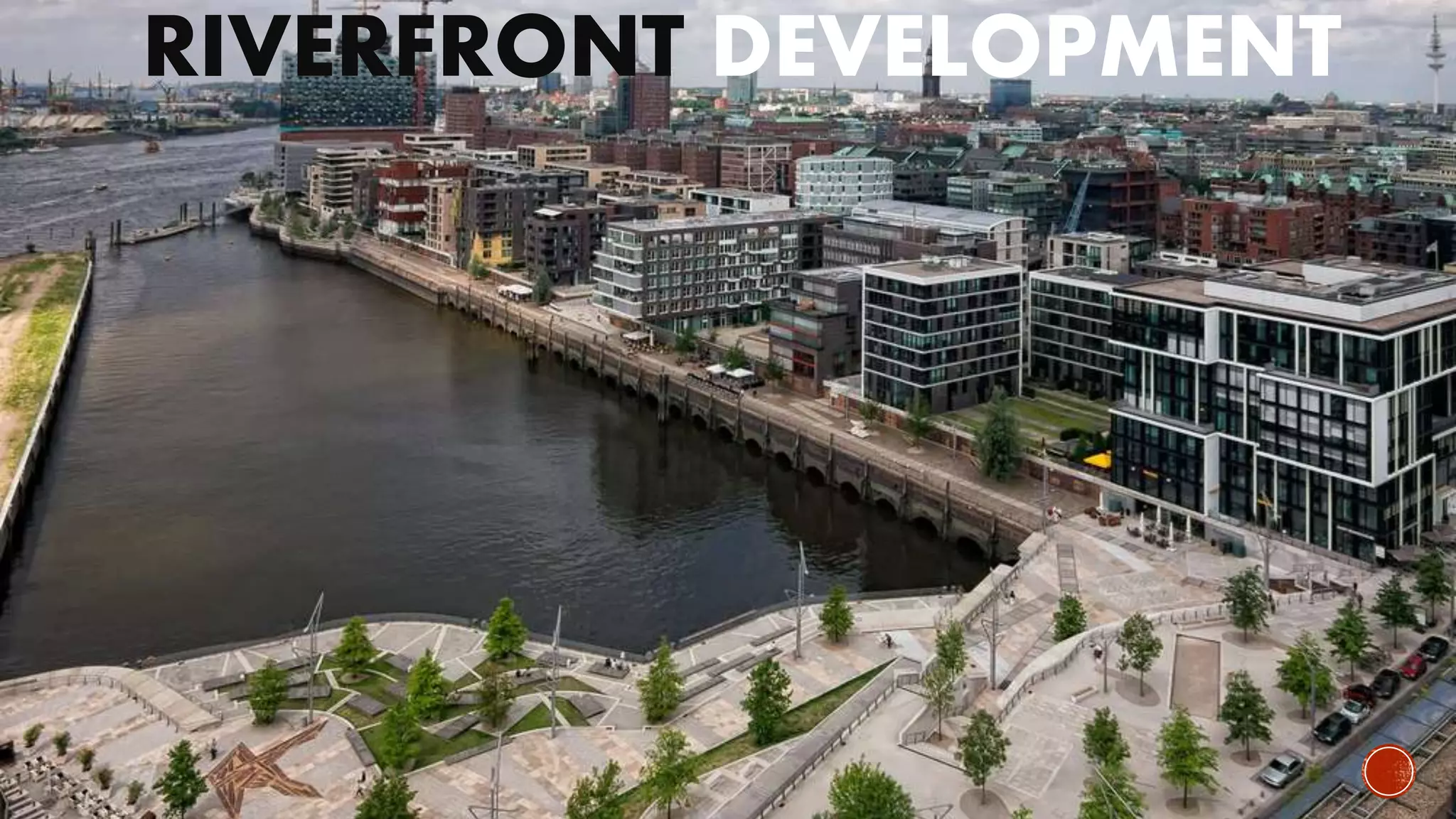
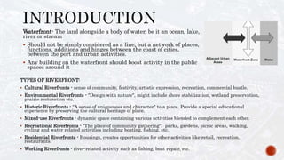
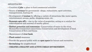
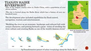
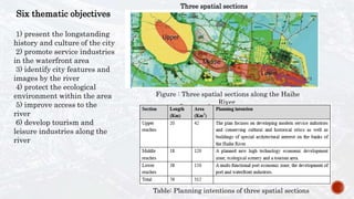
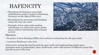
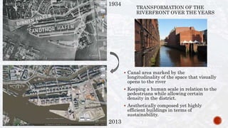
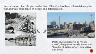
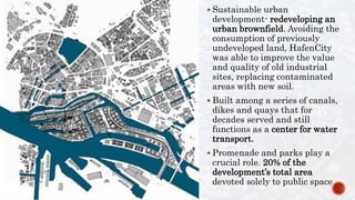
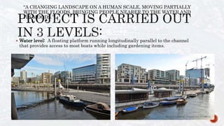
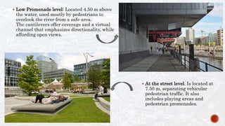
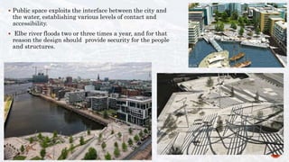
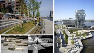
RIVERFRONT DEVELOPMENT
TYPES OF RIVERFRONT:
 Cultural Riverfronts - sense of community, festivity, artistic expression, recreation, commercial bustle.
 Environmental Riverfronts - "Design with nature", might include shore stabilization, wetland preservation,
prairie restoration etc.
 Historic Riverfronts - "A sense of uniqueness and character" to a place. Provide a special educational
experience by preserving the cultural heritage of place.
 Mixed-use Riverfronts - dynamic space containing various activities blended to complement each other.
 Recreational Riverfronts - "The place of community gathering". parks, gardens, picnic areas, walking,
cycling and water related activities including boating, fishing, etc.
 Residential Riverfronts - Housings, creates opportunities for other activities like retail, recreation,
restaurants.
 Working Riverfronts - river-related activity such as fishing, boat repair, etc.
Waterfront- The land alongside a body of water, be it an ocean, lake,
river or stream
 Should not be simply considered as a line, but a network of places,
functions, additions and hinges between the coast of cities,
between the port and urban activities.
 Any building on the waterfront should boost activity in the public
spaces around it
ADVANTAGES:
 Creation of jobs- a place to host commercial activities
 Source of revenue for government –shops, restaurants, sport activities,
transportation, boating etc
 Development of tourism by offering a variety of attractions like water sports,
entertainment arenas, parks, shopping areas, etc.
 Economic spin-off’s – rise in the value of properties, acting as a catalyst for
redevelopment and renewal of nearby places.
 Habitat protection and restoration -Conservation of water in the river,
Human/Environmental connections, Conservation and development of land,
Conservation of flora and fauna
 Maintenance of river bank.
 Flood control measures
 Provide the general public with an open space for leisure and recreation.
 Revitalizing the neighborhood
 CREATES A HEALTHY AND ACTIVE URBAN ENVIRONMENT.
•One of the largest coastal cities in North China, with a population of over
eleven million.
•The city is located along the Haihe River which has a history of over six-
hundred-years
The development plan included capabilities for flood control,
navigation, tourism and entertainment.
“Building the river as an economic, landscape and cultural belt with
unique character, and putting forward a great vision of extolling the
river culture and creating Haihe as one of the world’s famous rivers"
fig:Transformation pattern of urban morphology along the Haihe River
MAP OF TIANJIN CITY AND
THE HAIHE RIVER
Three spatial sections
Figure : Three spatial sections along the Haihe
River
Six thematic objectives
1) present the longstanding
history and culture of the city
2) promote service industries
in the waterfront area
3) identify city features and
images by the river
4) protect the ecological
environment within the area
5) improve access to the
river
6) develop tourism and
leisure industries along the
river
Table: Planning intentions of three spatial sections
Redeveloping the riverfront:
b) Circulation
•No physical barrier between the water and inland
area.
•Slopes added for people with disabilities
•Old railway station at the riverfront in the city
center reorganised into a transport hub, with better
access to the underground, subway systems and bus
services
a)Land-use
• Old factories and aging residential
communities demolished
• Large parcels of land earmarked for mixed-
use or commercial purposes.
c) Urban fabric
•Dramatically changed after the redevelopment.
•Old low-rise and dense housing units replaced by clusters of high-rise
residential communities with commercial facilities
20092000
d) Built form
• visibility, permeability, and
openness maintained.
Waterfront is open and visible from a
distance, and with several skyscrapers
becoming new landmarks related to
the riverfront, a new skyline has now
been created.
In 2008
e) Vegetation:
f) Activity
•Swimming, fishing, or
sight-seeing by boat.
• Other non-water-
related, like general
parks or other public
open spaces
•Planting design for the
achieving a visual effect in
riverfront.
Dagu bridge
Music garden
Tian hou temple
Railway station
Tianjin eye and
yong le bridge
A public open space full of
possibilities!!
 Waterfront development and urban
rehabilitation project located in Hamburg,
Germany on the edge of Elbe river
 Revitalizing the downtown and bringing
urban life near the water
 Example of how cities with working
waterfronts can still create active public
places without interfering with economic
activity
Objectives:
 To protect it from flooding of Elbe river without overbearing the old quay walls
 reconnect Hamburg to the river
Achieved by raising the land beyond the quay walls and implementing public space
typologies such as promenades, piers, boulevards, stairs and terraces of different scales that
provide access to the river.
1934
2013
TRANSFORMATION OF THE
RIVERFRONT OVER THE YEARS
 Canal area marked by the
longitudinality of the space that visually
opens to the river
 Keeping a human scale in relation to the
pedestrians while allowing certain
density in the district.
 Aesthetically composed yet highly
efficient buildings in terms of
sustainability.
Revitalization of an old pier on the River Elbe that had been affected during the
war and was abandoned by disuse and deterioration.
Ports once considered as “no-go
areas”, dangerous unsafe zones, and
“facades of ugliness” are now active
and lively
 Sustainable urban
development- redeveloping an
urban brownfield. Avoiding the
consumption of previously
undeveloped land, HafenCity
was able to improve the value
and quality of old industrial
sites, replacing contaminated
areas with new soil.
 Built among a series of canals,
dikes and quays that for
decades served and still
functions as a center for water
transport.
 Promenade and parks play a
crucial role. 20% of the
development’s total area
devoted solely to public space
Flood protection and wharf concept in the
HafenCity, where parts of the promenades
can be overflooded (line means 8.30 over zero
= safe).
 Water level: A floating platform running longitudinally parallel to the channel
that provides access to most boats while including gardening items.
“A CHANGING LANDSCAPE ON A HUMAN SCALE, MOVING PARTIALLY
WITH THE FLOODS, BRINGING PEOPLE NEARER TO THE WATER AND
ITS MOODS.”
 Low Promenade level: Located 4.50 m above
the water, used mostly by pedestrians to
overlook the river from a safe area.
The cantilevers offer coverage and a virtual
channel that emphasizes directionality, while
affording open views.
 At the street level. Is located at
7.50 m, separating vehicular
pedestrian traffic. It also
includes playing areas and
pedestrian promenades.
 Public space exploits the interface between the city and
the water, establishing various levels of contact and
accessibility.
 Elbe river floods two or three times a year, and for that
reason the design should provide security for the people
and structures.
CREATING SPACES THAT ATTRACT
VARIOUS ACTIVITIES !
CONCLUSION
• Showcase the river’s history
-History plays an important role in shaping a place.
-It gives any place its unique identity.
-It can also be used to educate people about the place.
• Activate the riverfront
-Recreation/Fitness
-Tourism improves the economic wealth of the city.
• Public accessibility
-Limit obstacles and connect to the river.
-Convenient means for visitors to access the waterfront area.
-Trails, walkways, beaches, along rivers provided.
-There should be multiple entry points to the river so as to
have a successful riverfront with active use.
• Local participation
• Ensure That New Development Fits Within The Community’s
Vision
• Bank stabilization
-The accessibility factor along with bank stabilization measures.
• Encourage 24-hour Activity By Limiting Residential Development
• Employ high quality architectural materials and sustainable engineering practices
-By selecting building materials, heights, native plants or landscaping, reusing
disturbed areas and building within the context.
• Engage with the water
-Existing activities like fishing, boating,
repair yards etc. along the river give it a
character.
-Newer development should not totally
take away the existing activities
• Liability
-Building near water can be hazardous for people.
-With easy accessibility to water there are certain
liabilities like drowning or falling from walkways
with no railing on them.
Waterfront development

Waterfront development

  • 1.
  • 2.
    TYPES OF RIVERFRONT: Cultural Riverfronts - sense of community, festivity, artistic expression, recreation, commercial bustle.  Environmental Riverfronts - "Design with nature", might include shore stabilization, wetland preservation, prairie restoration etc.  Historic Riverfronts - "A sense of uniqueness and character" to a place. Provide a special educational experience by preserving the cultural heritage of place.  Mixed-use Riverfronts - dynamic space containing various activities blended to complement each other.  Recreational Riverfronts - "The place of community gathering". parks, gardens, picnic areas, walking, cycling and water related activities including boating, fishing, etc.  Residential Riverfronts - Housings, creates opportunities for other activities like retail, recreation, restaurants.  Working Riverfronts - river-related activity such as fishing, boat repair, etc. Waterfront- The land alongside a body of water, be it an ocean, lake, river or stream  Should not be simply considered as a line, but a network of places, functions, additions and hinges between the coast of cities, between the port and urban activities.  Any building on the waterfront should boost activity in the public spaces around it
  • 3.
    ADVANTAGES:  Creation ofjobs- a place to host commercial activities  Source of revenue for government –shops, restaurants, sport activities, transportation, boating etc  Development of tourism by offering a variety of attractions like water sports, entertainment arenas, parks, shopping areas, etc.  Economic spin-off’s – rise in the value of properties, acting as a catalyst for redevelopment and renewal of nearby places.  Habitat protection and restoration -Conservation of water in the river, Human/Environmental connections, Conservation and development of land, Conservation of flora and fauna  Maintenance of river bank.  Flood control measures  Provide the general public with an open space for leisure and recreation.  Revitalizing the neighborhood  CREATES A HEALTHY AND ACTIVE URBAN ENVIRONMENT.
  • 4.
    •One of thelargest coastal cities in North China, with a population of over eleven million. •The city is located along the Haihe River which has a history of over six- hundred-years The development plan included capabilities for flood control, navigation, tourism and entertainment. “Building the river as an economic, landscape and cultural belt with unique character, and putting forward a great vision of extolling the river culture and creating Haihe as one of the world’s famous rivers" fig:Transformation pattern of urban morphology along the Haihe River MAP OF TIANJIN CITY AND THE HAIHE RIVER
  • 5.
    Three spatial sections Figure: Three spatial sections along the Haihe River Six thematic objectives 1) present the longstanding history and culture of the city 2) promote service industries in the waterfront area 3) identify city features and images by the river 4) protect the ecological environment within the area 5) improve access to the river 6) develop tourism and leisure industries along the river Table: Planning intentions of three spatial sections
  • 6.
    Redeveloping the riverfront: b)Circulation •No physical barrier between the water and inland area. •Slopes added for people with disabilities •Old railway station at the riverfront in the city center reorganised into a transport hub, with better access to the underground, subway systems and bus services a)Land-use • Old factories and aging residential communities demolished • Large parcels of land earmarked for mixed- use or commercial purposes.
  • 7.
    c) Urban fabric •Dramaticallychanged after the redevelopment. •Old low-rise and dense housing units replaced by clusters of high-rise residential communities with commercial facilities 20092000 d) Built form • visibility, permeability, and openness maintained. Waterfront is open and visible from a distance, and with several skyscrapers becoming new landmarks related to the riverfront, a new skyline has now been created. In 2008 e) Vegetation: f) Activity •Swimming, fishing, or sight-seeing by boat. • Other non-water- related, like general parks or other public open spaces •Planting design for the achieving a visual effect in riverfront.
  • 8.
    Dagu bridge Music garden Tianhou temple Railway station Tianjin eye and yong le bridge
  • 9.
    A public openspace full of possibilities!!
  • 10.
     Waterfront developmentand urban rehabilitation project located in Hamburg, Germany on the edge of Elbe river  Revitalizing the downtown and bringing urban life near the water  Example of how cities with working waterfronts can still create active public places without interfering with economic activity Objectives:  To protect it from flooding of Elbe river without overbearing the old quay walls  reconnect Hamburg to the river Achieved by raising the land beyond the quay walls and implementing public space typologies such as promenades, piers, boulevards, stairs and terraces of different scales that provide access to the river.
  • 11.
    1934 2013 TRANSFORMATION OF THE RIVERFRONTOVER THE YEARS  Canal area marked by the longitudinality of the space that visually opens to the river  Keeping a human scale in relation to the pedestrians while allowing certain density in the district.  Aesthetically composed yet highly efficient buildings in terms of sustainability.
  • 12.
    Revitalization of anold pier on the River Elbe that had been affected during the war and was abandoned by disuse and deterioration. Ports once considered as “no-go areas”, dangerous unsafe zones, and “facades of ugliness” are now active and lively
  • 13.
     Sustainable urban development-redeveloping an urban brownfield. Avoiding the consumption of previously undeveloped land, HafenCity was able to improve the value and quality of old industrial sites, replacing contaminated areas with new soil.  Built among a series of canals, dikes and quays that for decades served and still functions as a center for water transport.  Promenade and parks play a crucial role. 20% of the development’s total area devoted solely to public space
  • 14.
    Flood protection andwharf concept in the HafenCity, where parts of the promenades can be overflooded (line means 8.30 over zero = safe).
  • 15.
     Water level:A floating platform running longitudinally parallel to the channel that provides access to most boats while including gardening items. “A CHANGING LANDSCAPE ON A HUMAN SCALE, MOVING PARTIALLY WITH THE FLOODS, BRINGING PEOPLE NEARER TO THE WATER AND ITS MOODS.”
  • 16.
     Low Promenadelevel: Located 4.50 m above the water, used mostly by pedestrians to overlook the river from a safe area. The cantilevers offer coverage and a virtual channel that emphasizes directionality, while affording open views.  At the street level. Is located at 7.50 m, separating vehicular pedestrian traffic. It also includes playing areas and pedestrian promenades.
  • 17.
     Public spaceexploits the interface between the city and the water, establishing various levels of contact and accessibility.  Elbe river floods two or three times a year, and for that reason the design should provide security for the people and structures.
  • 19.
    CREATING SPACES THATATTRACT VARIOUS ACTIVITIES !
  • 20.
    CONCLUSION • Showcase theriver’s history -History plays an important role in shaping a place. -It gives any place its unique identity. -It can also be used to educate people about the place. • Activate the riverfront -Recreation/Fitness -Tourism improves the economic wealth of the city. • Public accessibility -Limit obstacles and connect to the river. -Convenient means for visitors to access the waterfront area. -Trails, walkways, beaches, along rivers provided. -There should be multiple entry points to the river so as to have a successful riverfront with active use. • Local participation • Ensure That New Development Fits Within The Community’s Vision
  • 21.
    • Bank stabilization -Theaccessibility factor along with bank stabilization measures. • Encourage 24-hour Activity By Limiting Residential Development • Employ high quality architectural materials and sustainable engineering practices -By selecting building materials, heights, native plants or landscaping, reusing disturbed areas and building within the context. • Engage with the water -Existing activities like fishing, boating, repair yards etc. along the river give it a character. -Newer development should not totally take away the existing activities • Liability -Building near water can be hazardous for people. -With easy accessibility to water there are certain liabilities like drowning or falling from walkways with no railing on them.