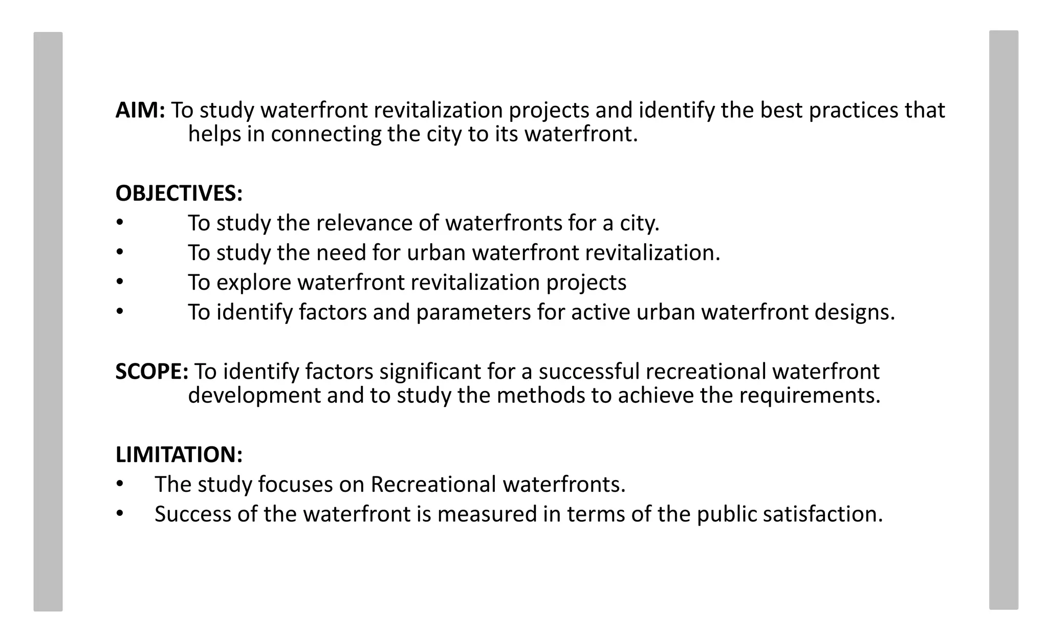
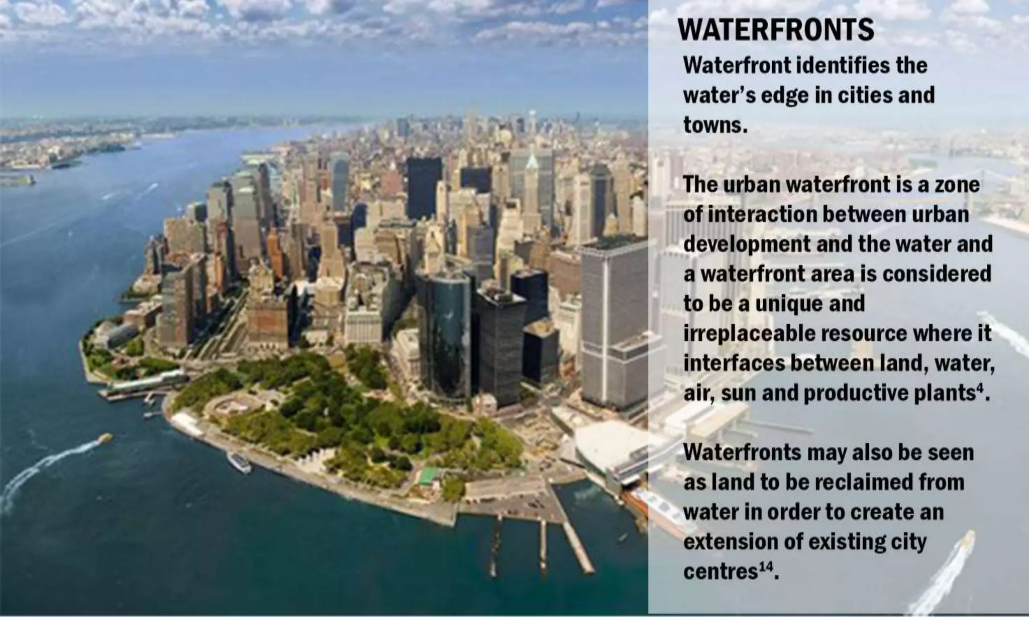
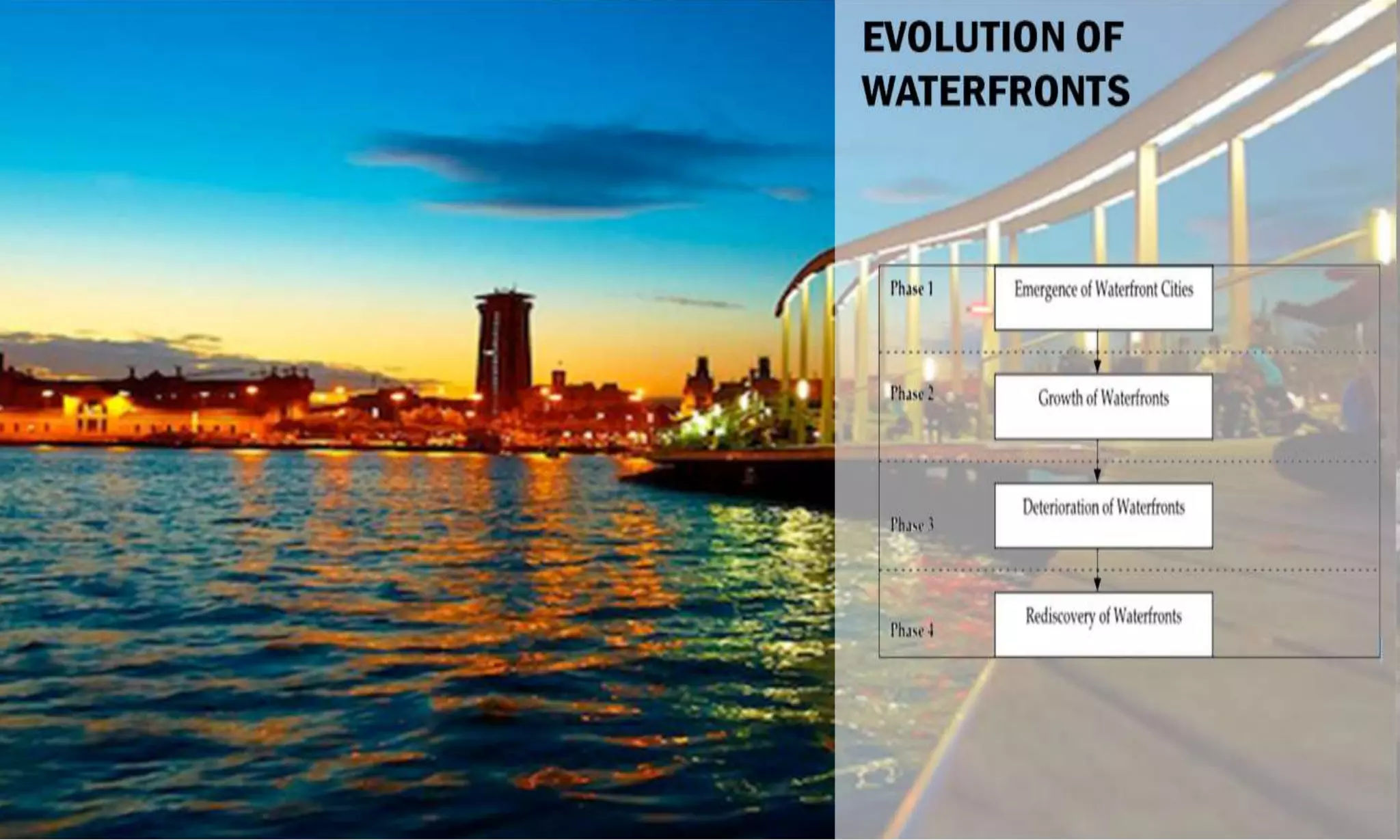
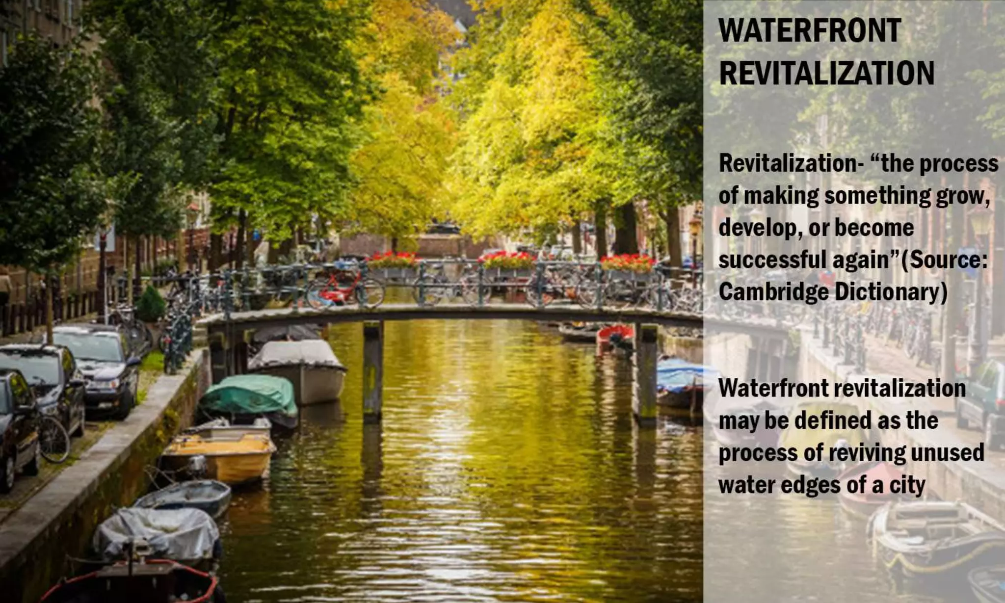
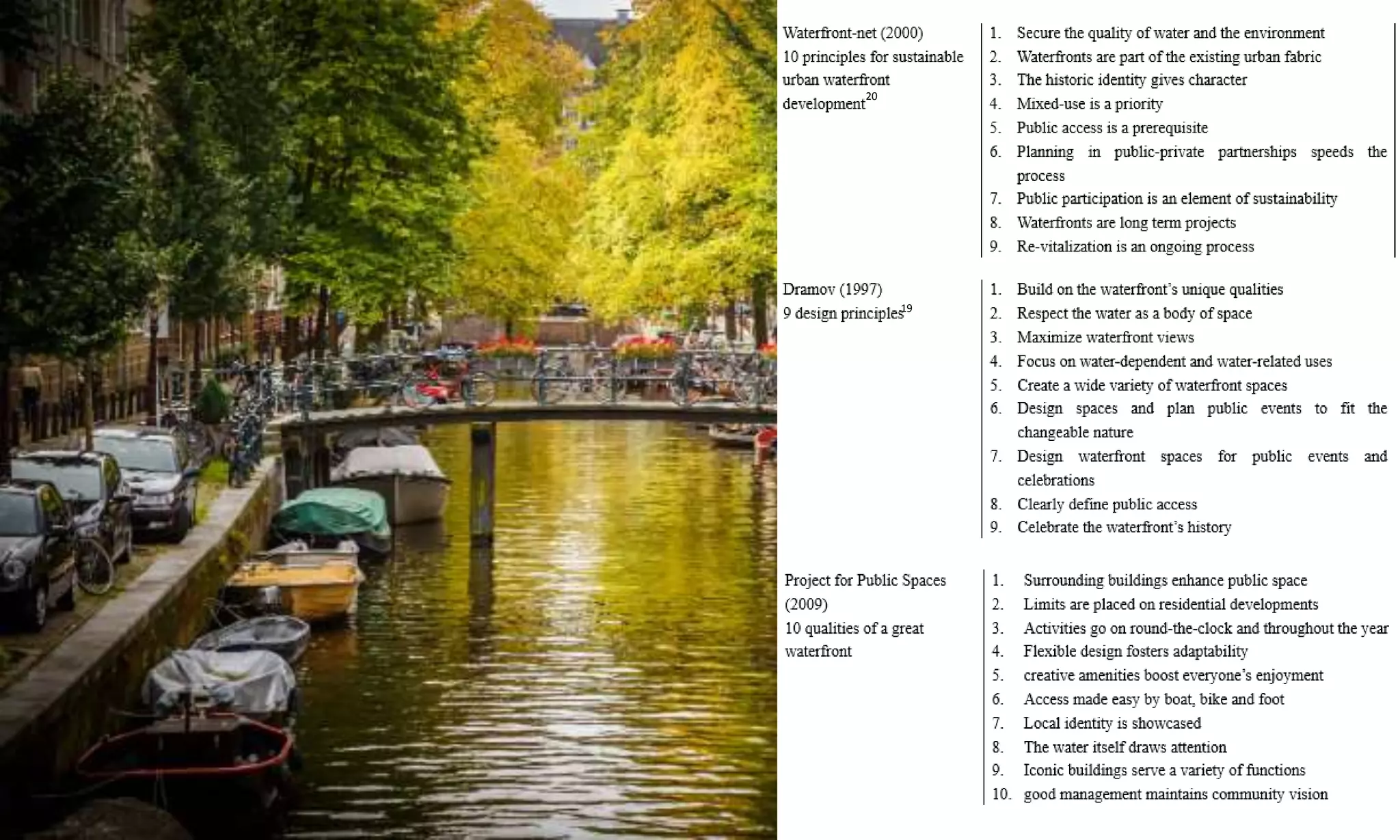
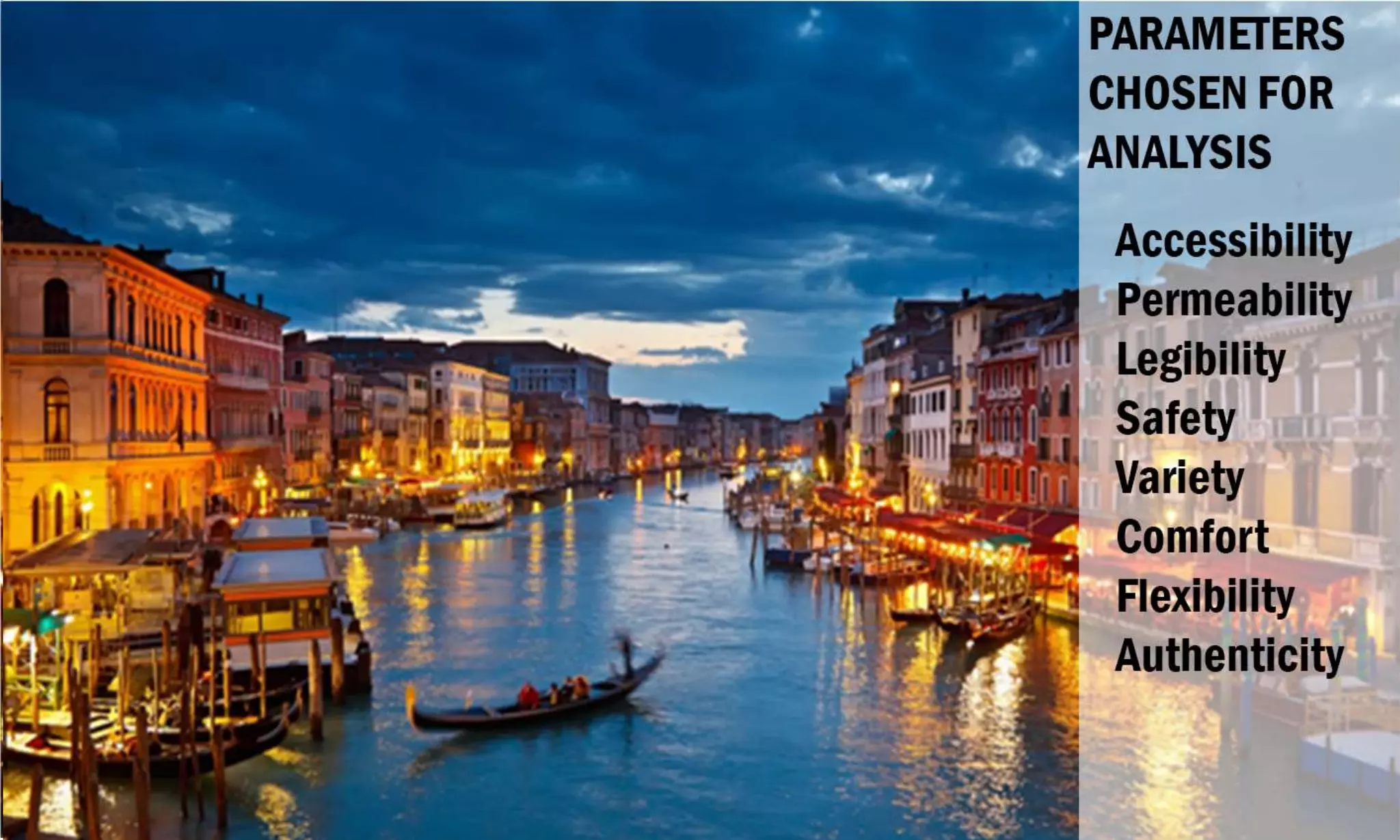
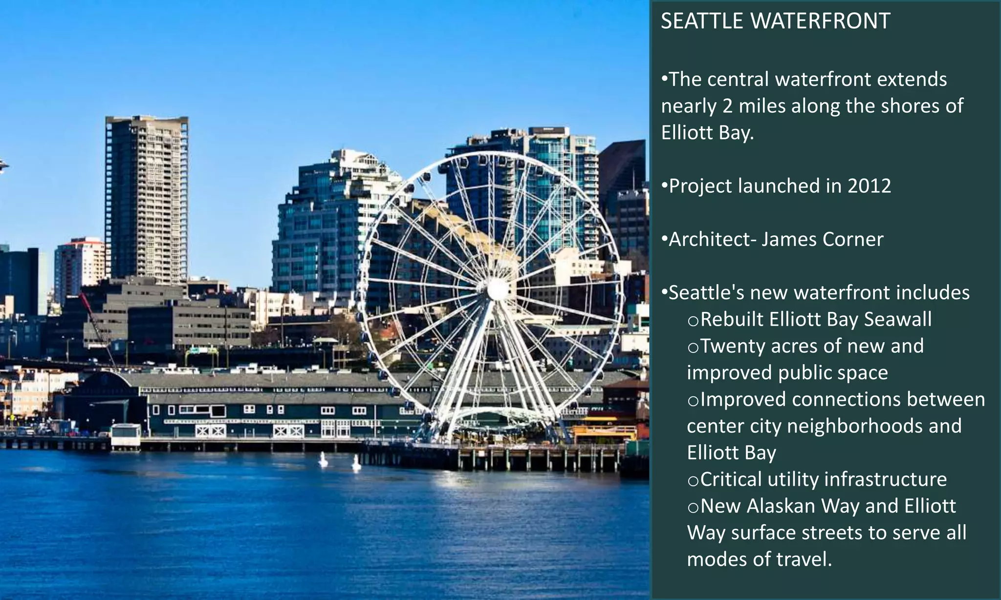
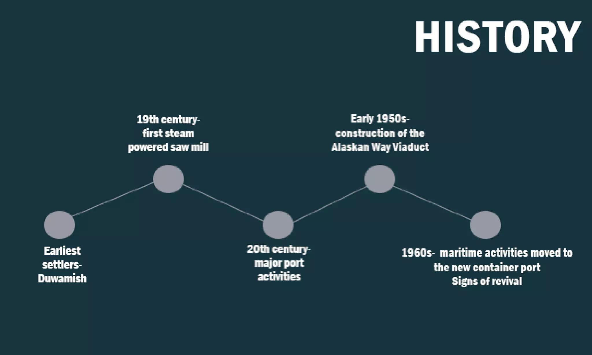
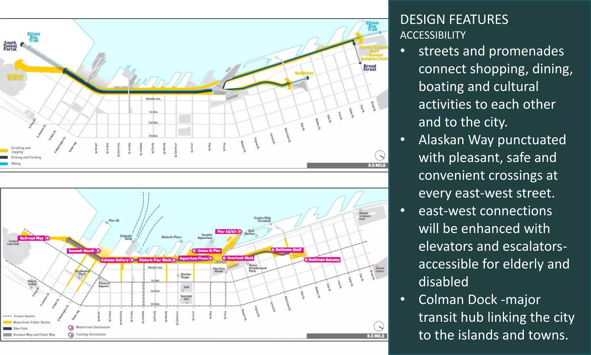
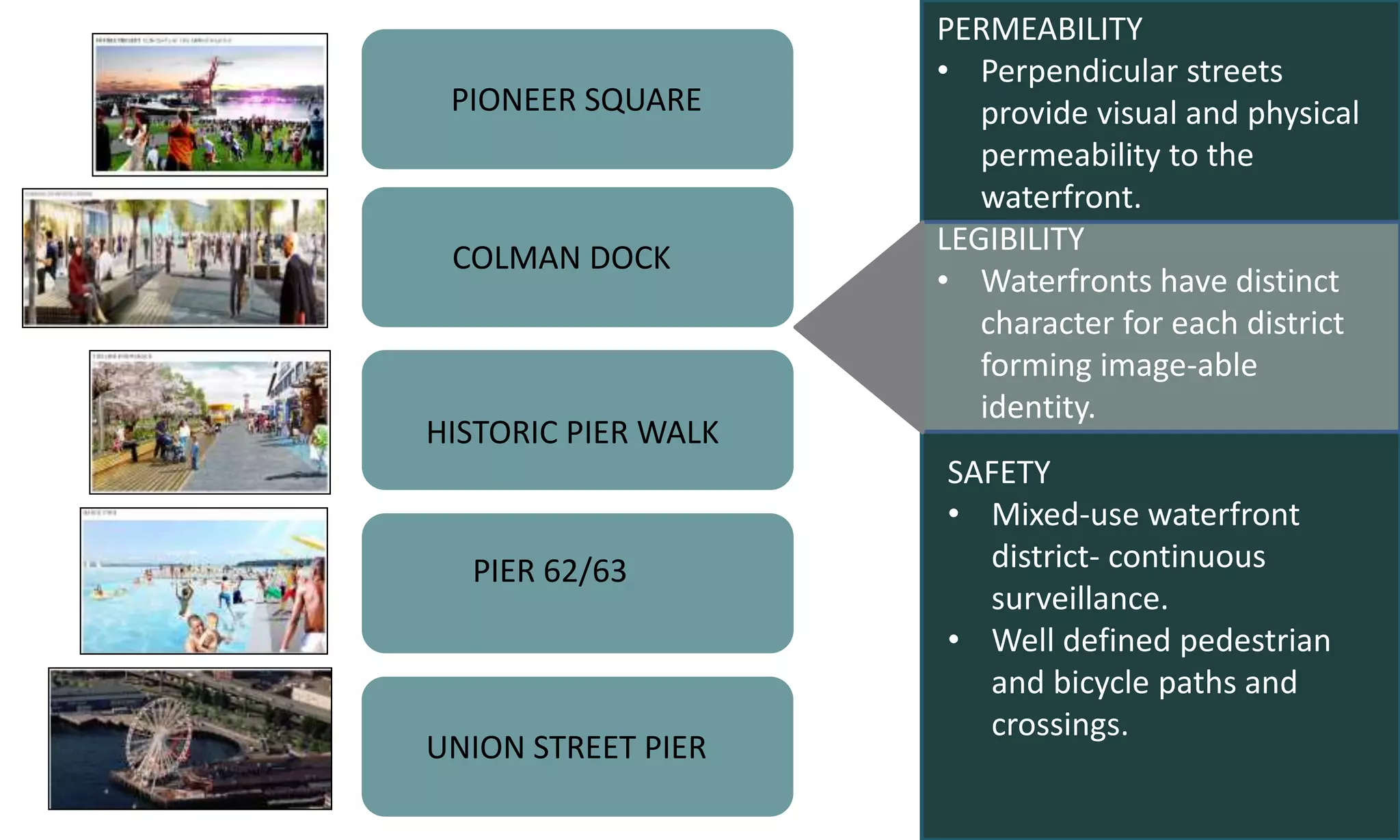
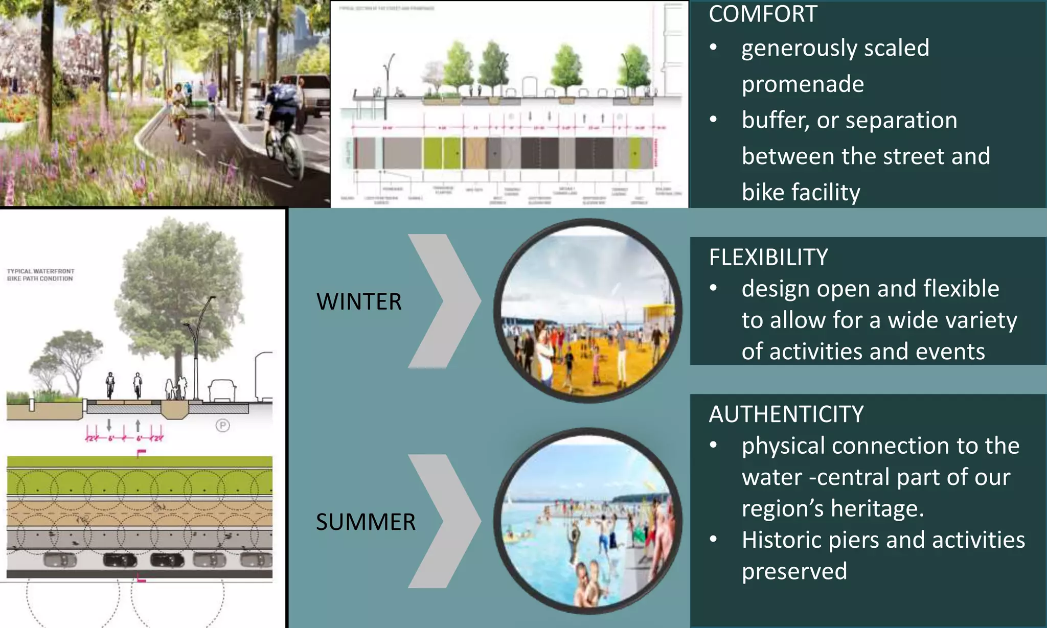
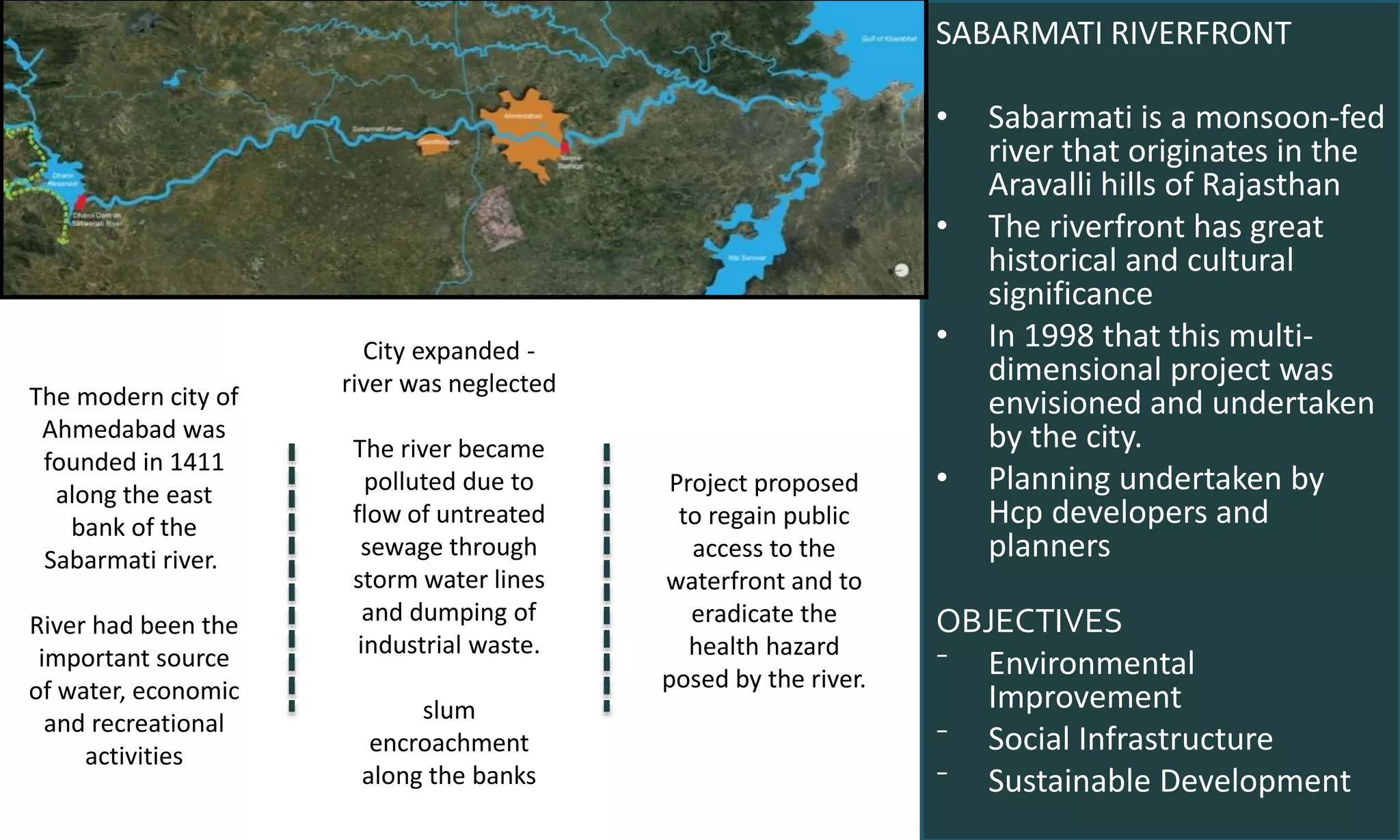
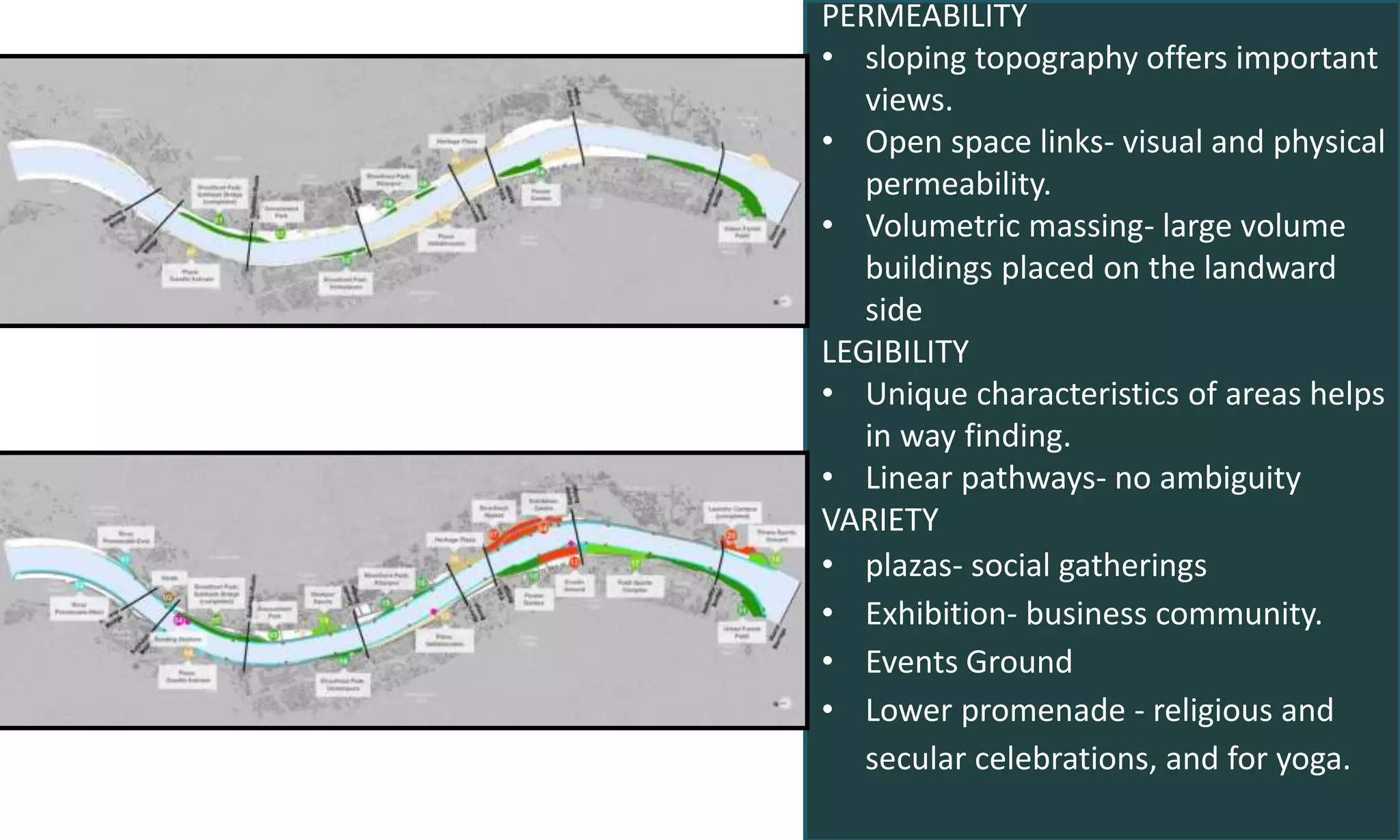
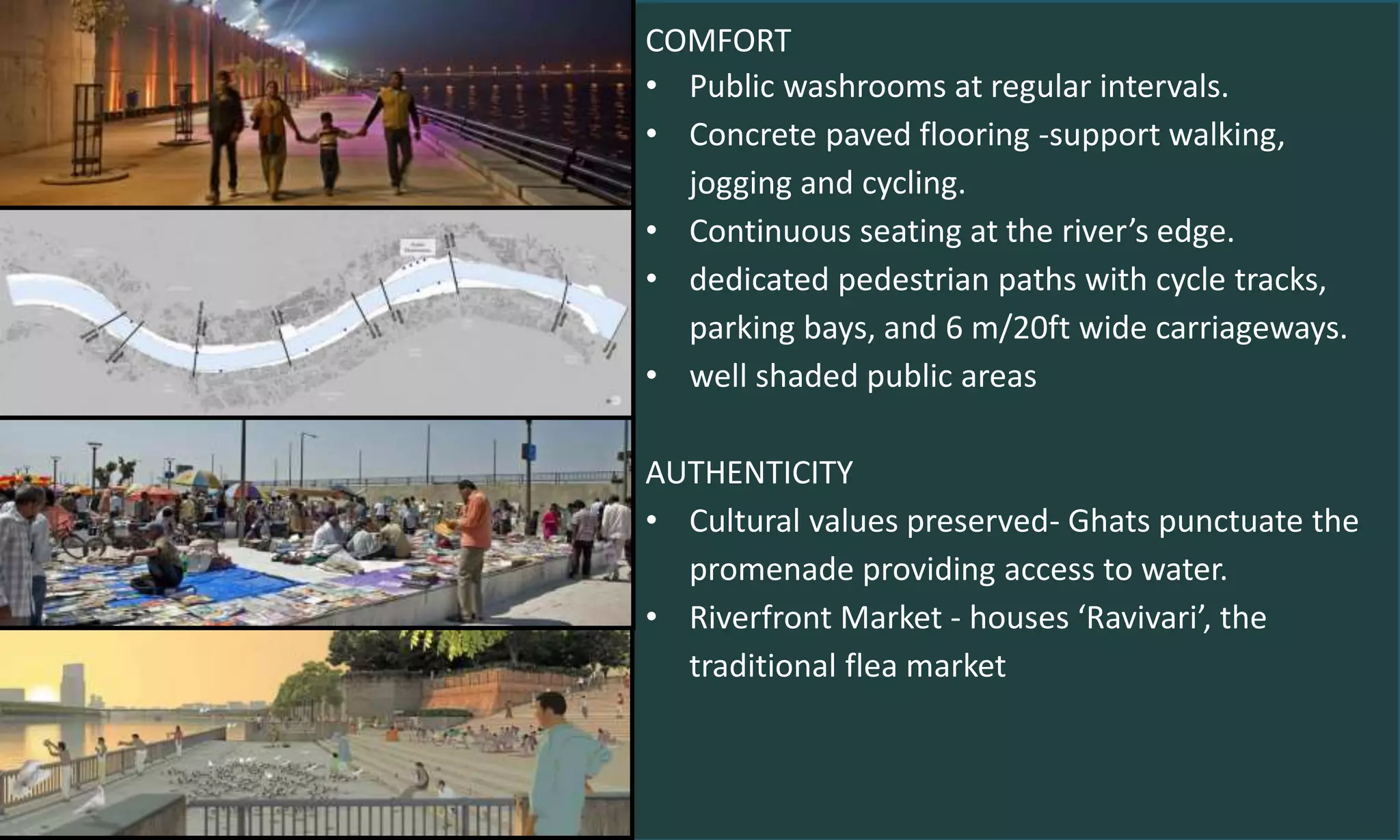
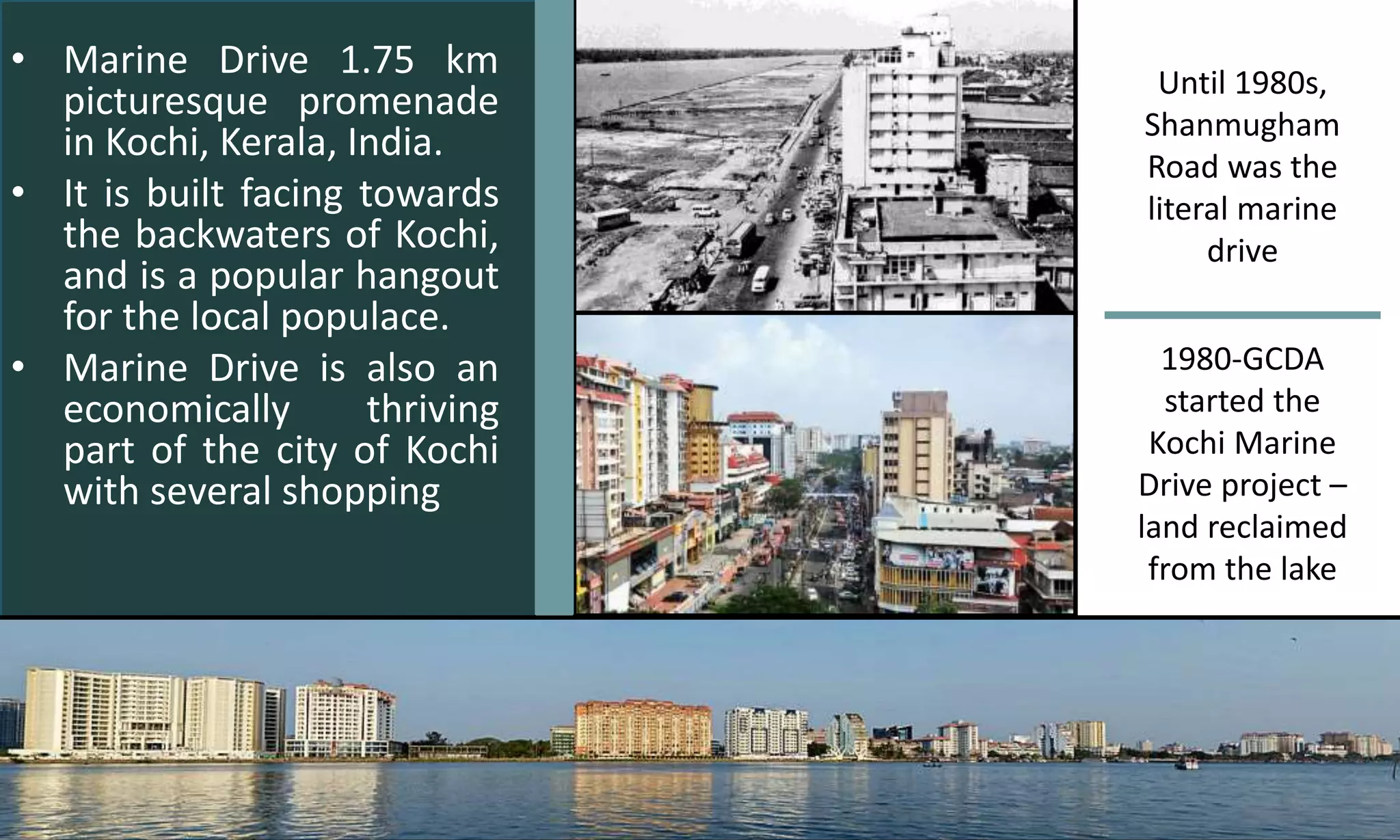
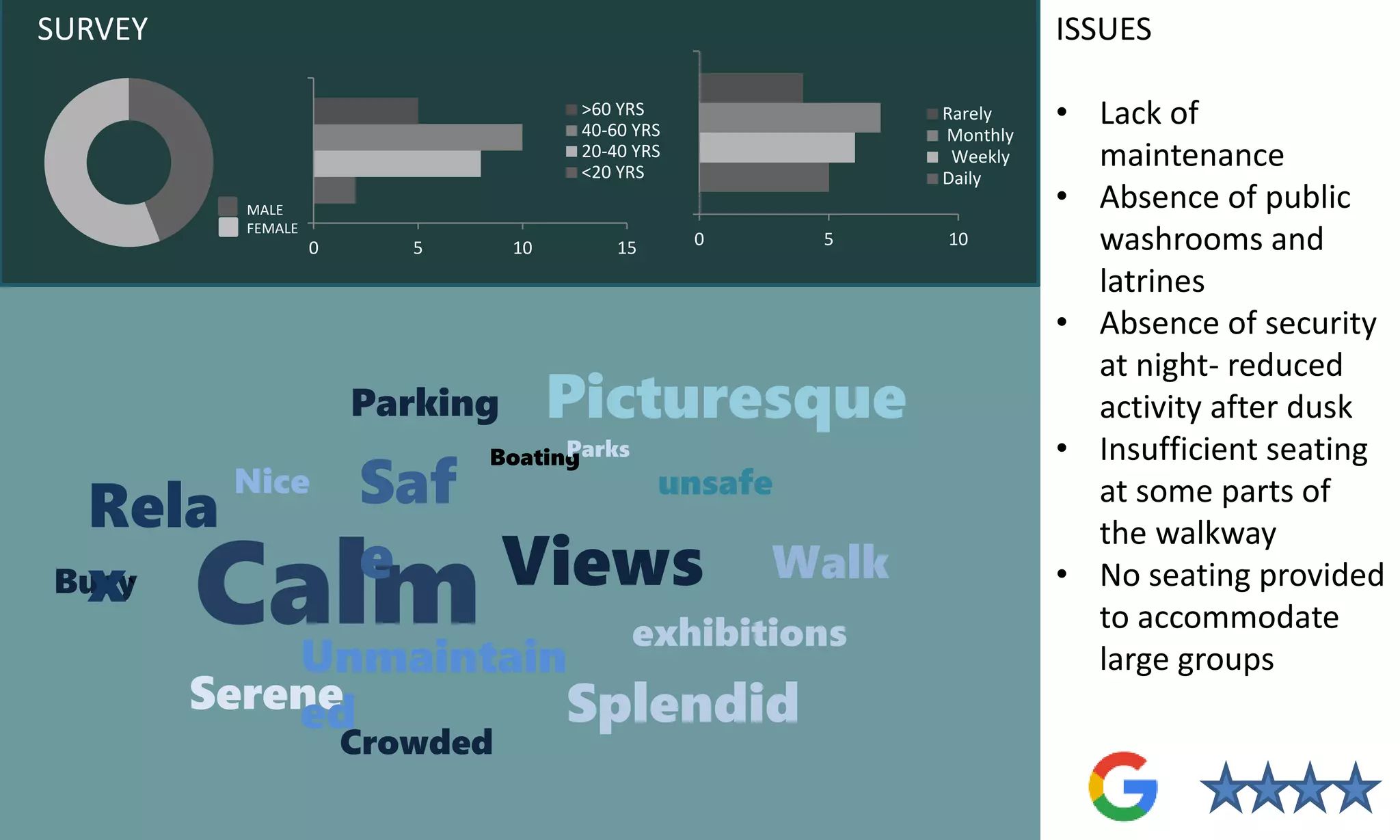
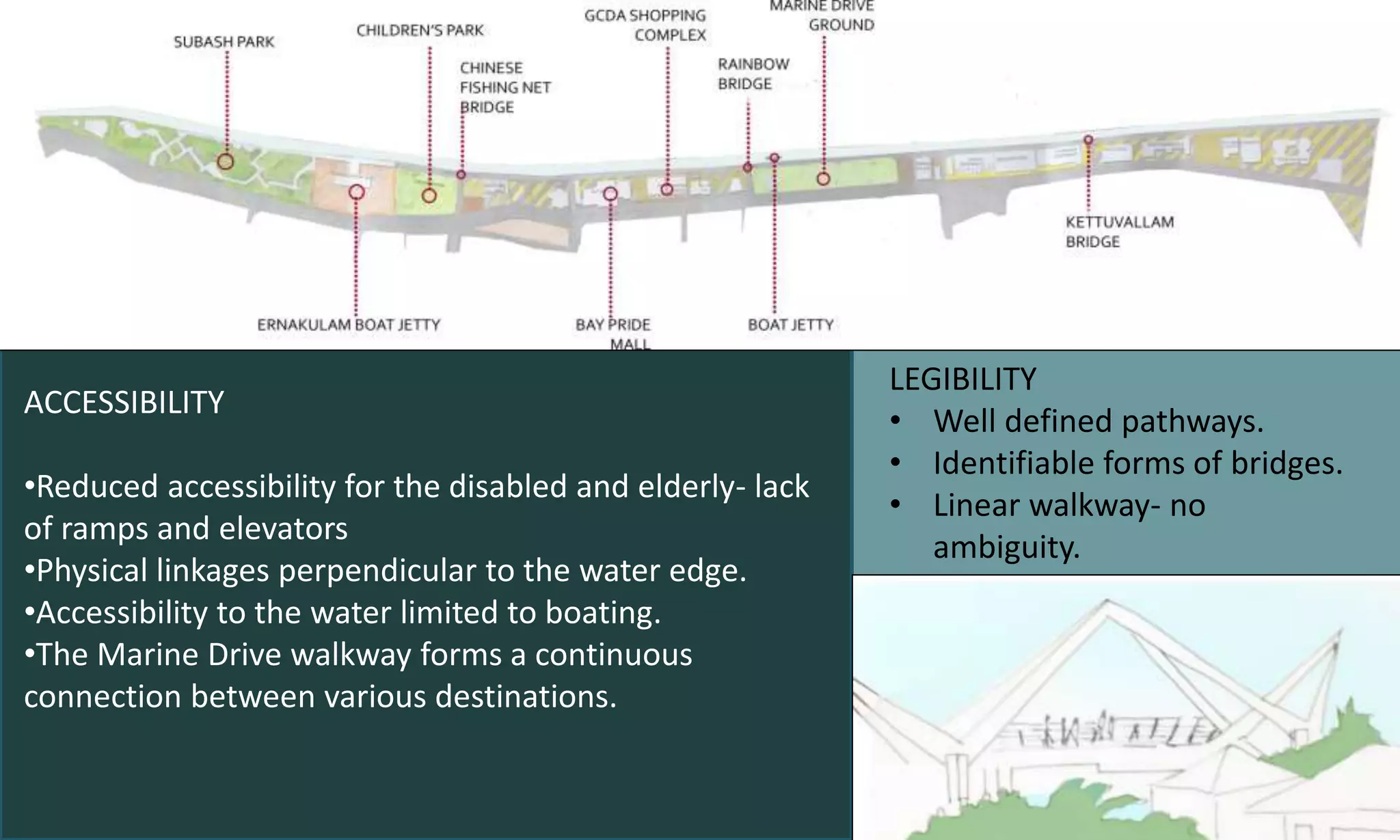
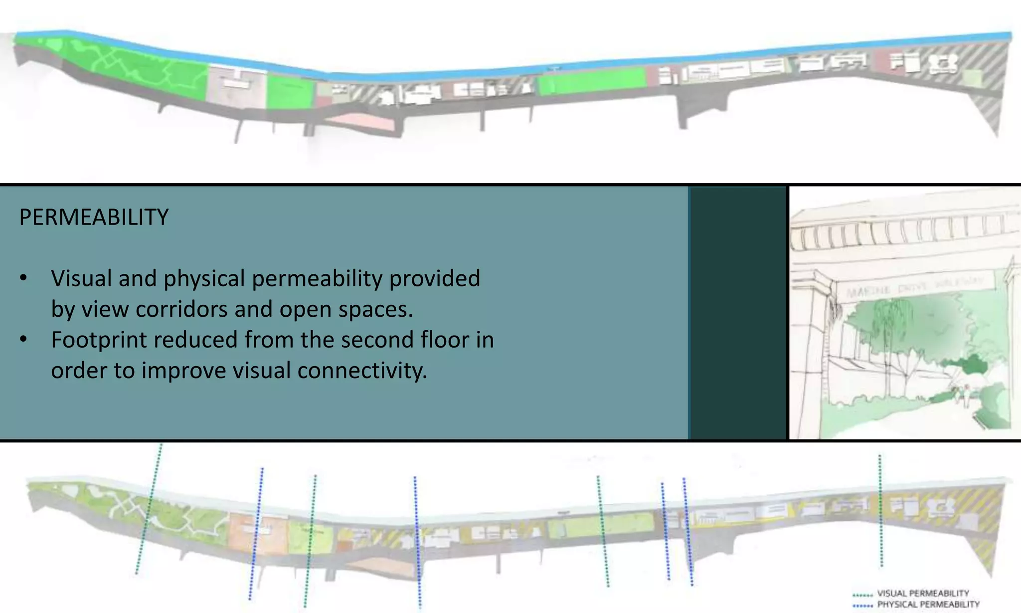
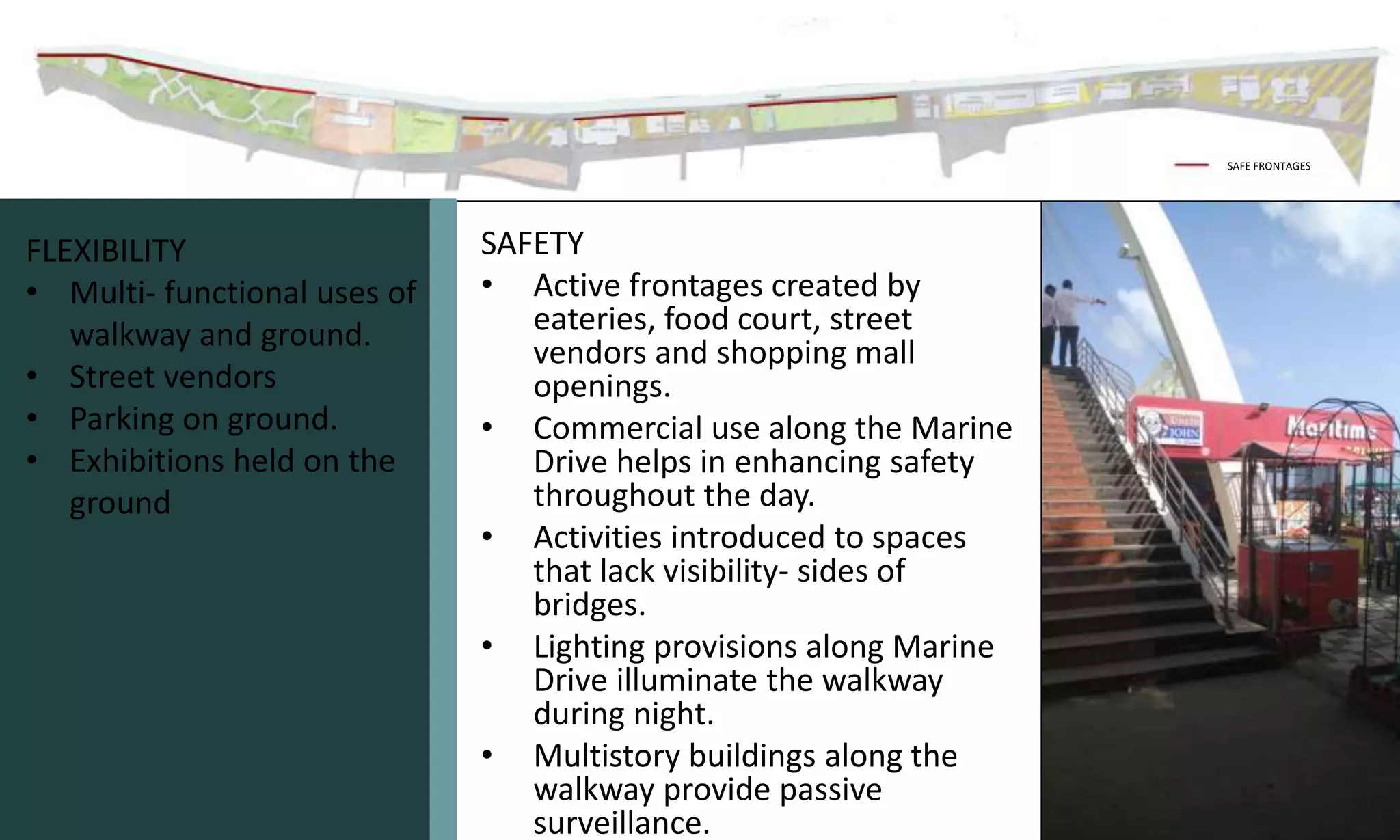
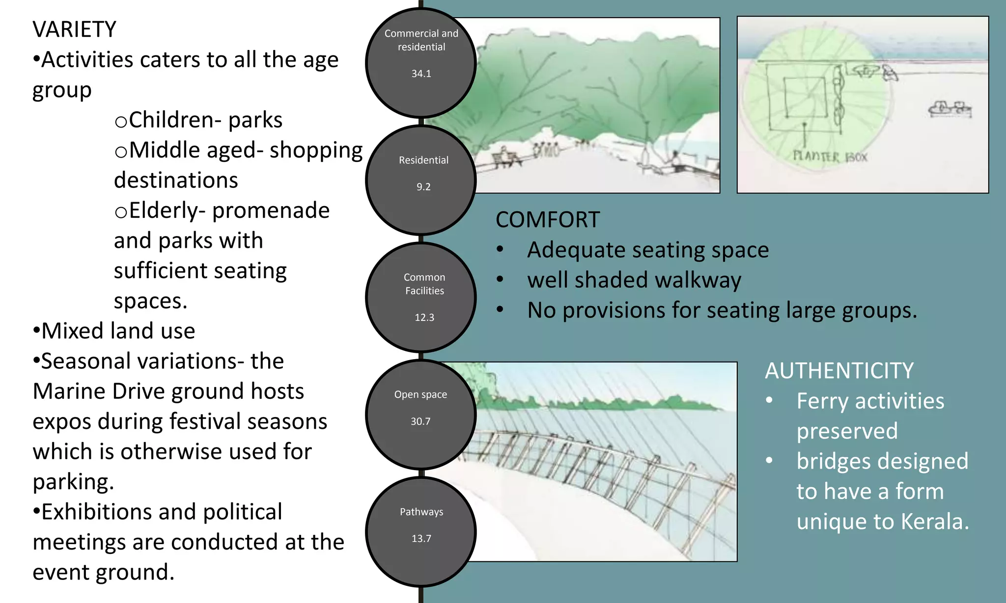
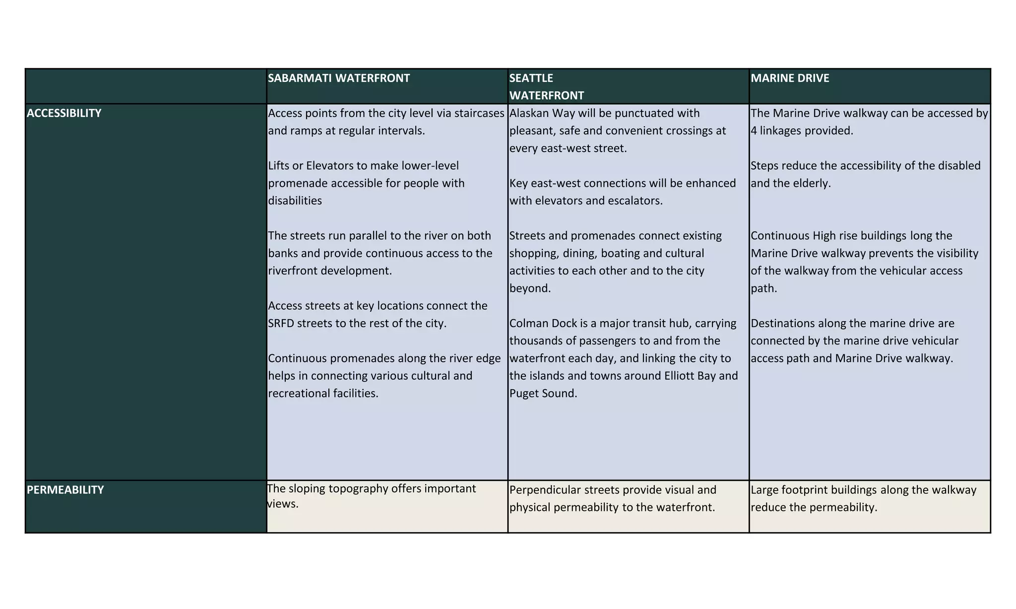
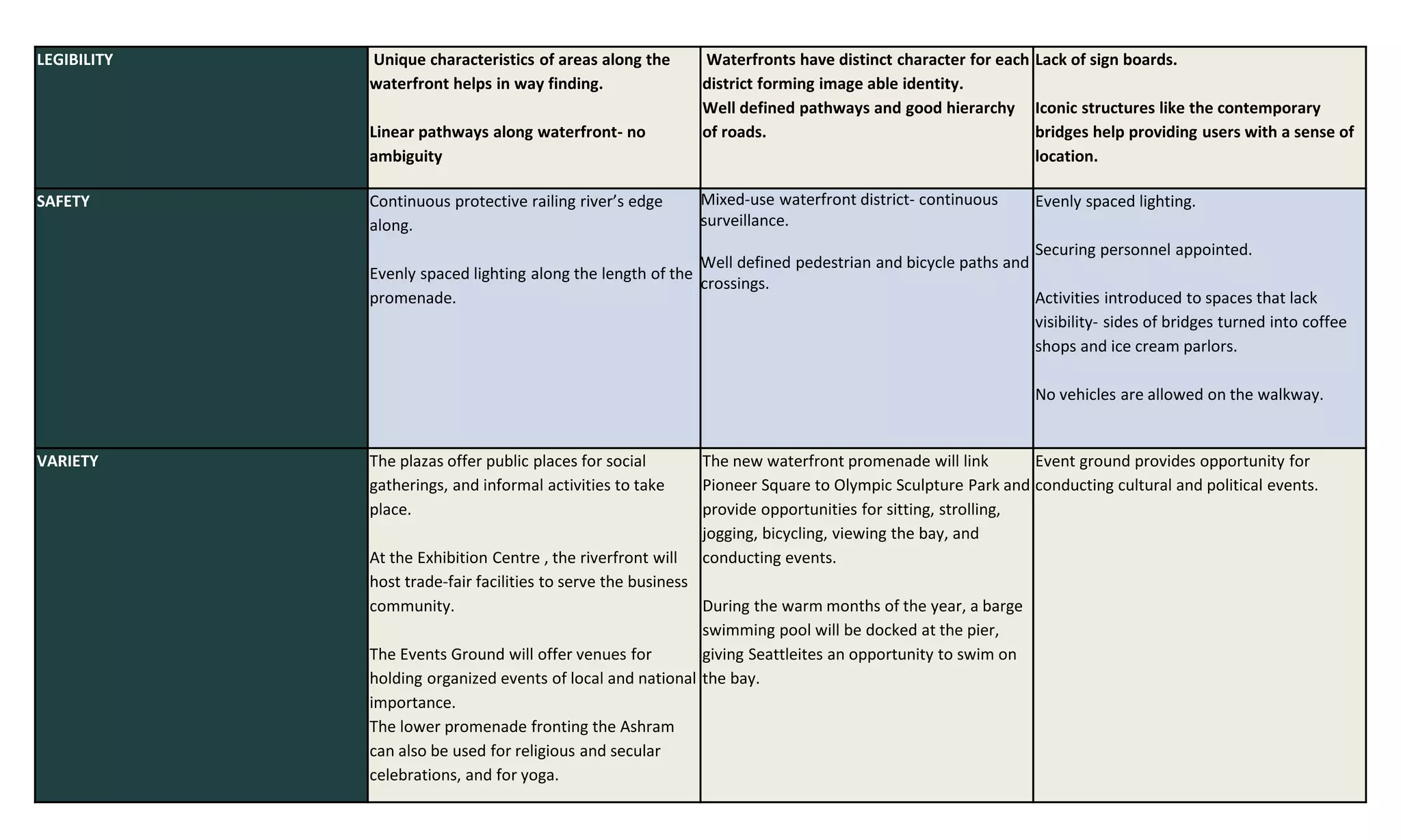
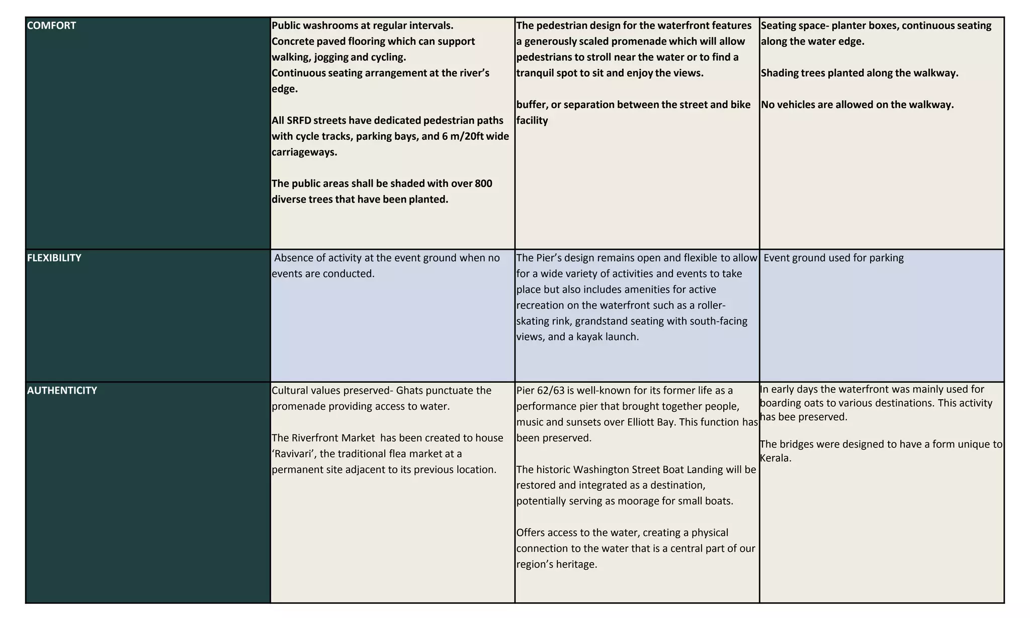
AIM: To study waterfront revitalization projects and identify the best practices that
helps in connecting the city to its waterfront.
OBJECTIVES:
• To study the relevance of waterfronts for a city.
• To study the need for urban waterfront revitalization.
• To explore waterfront revitalization projects
• To identify factors and parameters for active urban waterfront designs.
SCOPE: To identify factors significant for a successful recreational waterfront
development and to study the methods to achieve the requirements.
LIMITATION:
• The study focuses on Recreational waterfronts.
• Success of the waterfront is measured in terms of the public satisfaction.
19
20
SEATTLE WATERFRONT
SEATTLE WATERFRONT
•The central waterfront extends
nearly 2 miles along the shores of
Elliott Bay.
•Project launched in 2012
•Architect- James Corner
•Seattle's new waterfront includes
oRebuilt Elliott Bay Seawall
oTwenty acres of new and
improved public space
oImproved connections between
center city neighborhoods and
Elliott Bay
oCritical utility infrastructure
oNew Alaskan Way and Elliott
Way surface streets to serve all
modes of travel.
HISTORY OF SEATTLE
WATERFRONT
• Earliest settlements-
Duwamish
• 19th century
• 20th century- major port
activities
• With maritime activity
moving elsewhere, especially
to the new container port
south of the Central
Waterfront, people began to
consider the potential
importance of the Central
Waterfront as a tourist
destination.
DESIGN FEATURES
ACCESSIBILITY
• streets and promenades
connect shopping, dining,
boating and cultural
activities to each other
and to the city.
• Alaskan Way punctuated
with pleasant, safe and
convenient crossings at
every east-west street.
• east-west connections
will be enhanced with
elevators and escalators-
accessible for elderly and
disabled
• Colman Dock -major
transit hub linking the city
to the islands and towns.
PERMEABILITY
• Perpendicular streets
provide visual and physical
permeability to the
waterfront.
LEGIBILITY
• Waterfronts have distinct
character for each district
forming image-able
identity.
PIONEER SQUARE
COLMAN DOCK
HISTORIC PIER WALK
PIER 62/63
UNION STREET PIER
SAFETY
• Mixed-use waterfront
district- continuous
surveillance.
• Well defined pedestrian
and bicycle paths and
crossings.
COMFORT
• generously scaled
promenade
• buffer, or separation
between the street and
bike facility
FLEXIBILITY
• design open and flexible
to allow for a wide variety
of activities and events
AUTHENTICITY
• physical connection to the
water -central part of our
region’s heritage.
• Historic piers and activities
preserved
WINTER
SUMMER
SABARMATI WATERFRONT
SABARMATI RIVERFRONT
• Sabarmati is a monsoon-fed
river that originates in the
Aravalli hills of Rajasthan
• The riverfront has great
historical and cultural
significance
• In 1998 that this multi-
dimensional project was
envisioned and undertaken
by the city.
• Planning undertaken by
Hcp developers and
planners
OBJECTIVES
⁻ Environmental
Improvement
⁻ Social Infrastructure
⁻ Sustainable Development
The modern city of
Ahmedabad was
founded in 1411
along the east
bank of the
Sabarmati river.
River had been the
important source
of water, economic
and recreational
activities
City expanded -
river was neglected
The river became
polluted due to
flow of untreated
sewage through
storm water lines
and dumping of
industrial waste.
slum
encroachment
along the banks
Project proposed
to regain public
access to the
waterfront and to
eradicate the
health hazard
posed by the river.
ACCESSIBILITY
• Access points from the
city level via staircases
and ramps at regular
intervals.
• Lifts or Elevators-
accessibility for people
with disabilities
• streets run parallel to
the river on both banks -
provide continuous
access to the riverfront
development.
• Bridges across river
connects the two river
banks
PERMEABILITY
• sloping topography offers important
views.
• Open space links- visual and physical
permeability.
• Volumetric massing- large volume
buildings placed on the landward
side
LEGIBILITY
• Unique characteristics of areas helps
in way finding.
• Linear pathways- no ambiguity
VARIETY
• plazas- social gatherings
• Exhibition- business community.
• Events Ground
• Lower promenade - religious and
secular celebrations, and for yoga.
COMFORT
• Public washrooms at regular intervals.
• Concrete paved flooring -support walking,
jogging and cycling.
• Continuous seating at the river’s edge.
• dedicated pedestrian paths with cycle tracks,
parking bays, and 6 m/20ft wide carriageways.
• well shaded public areas
AUTHENTICITY
• Cultural values preserved- Ghats punctuate the
promenade providing access to water.
• Riverfront Market - houses ‘Ravivari’, the
traditional flea market
MARINE DRIVE, ERNAKULAM
• Marine Drive 1.75 km
picturesque promenade
in Kochi, Kerala, India.
• It is built facing towards
the backwaters of Kochi,
and is a popular hangout
for the local populace.
• Marine Drive is also an
economically thriving
part of the city of Kochi
with several shopping
Until 1980s,
Shanmugham
Road was the
literal marine
drive
1980-GCDA
started the
Kochi Marine
Drive project –
land reclaimed
from the lake
Calm
Busy
Serene
Unmaintain
ed
Crowded
Splendid
Views
unsafe
Saf
e
Nice
Picturesque
Boating
Walk
Rela
x`
exhibitions
Parking
Parks
SURVEY
MALE
FEMALE
0 5 10 15
>60 YRS
40-60 YRS
20-40 YRS
<20 YRS
0 5 10
Rarely
Monthly
Weekly
Daily
ISSUES
• Lack of
maintenance
• Absence of public
washrooms and
latrines
• Absence of security
at night- reduced
activity after dusk
• Insufficient seating
at some parts of
the walkway
• No seating provided
to accommodate
large groups
ACCESSIBILITY
•Reduced accessibility for the disabled and elderly- lack
of ramps and elevators
•Physical linkages perpendicular to the water edge.
•Accessibility to the water limited to boating.
•The Marine Drive walkway forms a continuous
connection between various destinations.
LEGIBILITY
• Well defined pathways.
• Identifiable forms of bridges.
• Linear walkway- no
ambiguity.
PERMEABILITY
• Visual and physical permeability provided
by view corridors and open spaces.
• Footprint reduced from the second floor in
order to improve visual connectivity.
SAFETY
• Active frontages created by
eateries, food court, street
vendors and shopping mall
openings.
• Commercial use along the Marine
Drive helps in enhancing safety
throughout the day.
• Activities introduced to spaces
that lack visibility- sides of
bridges.
• Lighting provisions along Marine
Drive illuminate the walkway
during night.
• Multistory buildings along the
walkway provide passive
surveillance.
SAFE FRONTAGES
FLEXIBILITY
• Multi- functional uses of
walkway and ground.
• Street vendors
• Parking on ground.
• Exhibitions held on the
ground
VARIETY
•Activities caters to all the age
group
oChildren- parks
oMiddle aged- shopping
destinations
oElderly- promenade
and parks with
sufficient seating
spaces.
•Mixed land use
•Seasonal variations- the
Marine Drive ground hosts
expos during festival seasons
which is otherwise used for
parking.
•Exhibitions and political
meetings are conducted at the
event ground.
Commercial and
residential
34.1
Common
Facilities
12.3
Open space
30.7
Pathways
13.7
COMFORT
• Adequate seating space
• well shaded walkway
• No provisions for seating large groups.
AUTHENTICITY
• Ferry activities
preserved
• bridges designed
to have a form
unique to Kerala.
Residential
9.2
SABARMATI WATERFRONT SEATTLE
WATERFRONT
MARINE DRIVE
ACCESSIBILITY Access points from the city level via staircases
and ramps at regular intervals.
Lifts or Elevators to make lower-level
promenade accessible for people with
disabilities
The streets run parallel to the river on both
banks and provide continuous access to the
riverfront development.
Access streets at key locations connect the
SRFD streets to the rest of the city.
Continuous promenades along the river edge
helps in connecting various cultural and
recreational facilities.
Alaskan Way will be punctuated with
pleasant, safe and convenient crossings at
every east-west street.
Key east-west connections will be enhanced
with elevators and escalators.
Streets and promenades connect existing
shopping, dining, boating and cultural
activities to each other and to the city
beyond.
Colman Dock is a major transit hub, carrying
thousands of passengers to and from the
waterfront each day, and linking the city to
the islands and towns around Elliott Bay and
Puget Sound.
The Marine Drive walkway can be accessed by
4 linkages provided.
Steps reduce the accessibility of the disabled
and the elderly.
Continuous High rise buildings long the
Marine Drive walkway prevents the visibility
of the walkway from the vehicular access
path.
Destinations along the marine drive are
connected by the marine drive vehicular
access path and Marine Drive walkway.
PERMEABILITY The sloping topography offers important
views.
Perpendicular streets provide visual and
physical permeability to the waterfront.
Large footprint buildings along the walkway
reduce the permeability.
LEGIBILITY Unique characteristics of areas along the
waterfront helps in way finding.
Linear pathways along waterfront- no
ambiguity
Waterfronts have distinct character for each
district forming image able identity.
Well defined pathways and good hierarchy
of roads.
Lack of sign boards.
Iconic structures like the contemporary
bridges help providing users with a sense of
location.
SAFETY Continuous protective railing river’s edge
along.
Evenly spaced lighting along the length of the
promenade.
Mixed-use waterfront district- continuous
surveillance.
Well defined pedestrian and bicycle paths and
crossings.
Evenly spaced lighting.
Securing personnel appointed.
Activities introduced to spaces that lack
visibility- sides of bridges turned into coffee
shops and ice cream parlors.
No vehicles are allowed on the walkway.
VARIETY The plazas offer public places for social
gatherings, and informal activities to take
place.
At the Exhibition Centre , the riverfront will
host trade-fair facilities to serve the business
community.
The Events Ground will offer venues for
holding organized events of local and national
importance.
The lower promenade fronting the Ashram
can also be used for religious and secular
celebrations, and for yoga.
The new waterfront promenade will link
Pioneer Square to Olympic Sculpture Park and
provide opportunities for sitting, strolling,
jogging, bicycling, viewing the bay, and
conducting events.
During the warm months of the year, a barge
swimming pool will be docked at the pier,
giving Seattleites an opportunity to swim on
the bay.
Event ground provides opportunity for
conducting cultural and political events.
COMFORT Public washrooms at regular intervals.
Concrete paved flooring which can support
walking, jogging and cycling.
Continuous seating arrangement at the river’s
edge.
All SRFD streets have dedicated pedestrian paths
with cycle tracks, parking bays, and 6 m/20ft wide
carriageways.
The public areas shall be shaded with over 800
diverse trees that have been planted.
The pedestrian design for the waterfront features
a generously scaled promenade which will allow
pedestrians to stroll near the water or to find a
tranquil spot to sit and enjoy the views.
buffer, or separation between the street and bike
facility
Seating space- planter boxes, continuous seating
along the water edge.
Shading trees planted along the walkway.
No vehicles are allowed on the walkway.
FLEXIBILITY Absence of activity at the event ground when no
events are conducted.
The Pier’s design remains open and flexible to allow
for a wide variety of activities and events to take
place but also includes amenities for active
recreation on the waterfront such as a roller-
skating rink, grandstand seating with south-facing
views, and a kayak launch.
Event ground used for parking
AUTHENTICITY Cultural values preserved- Ghats punctuate the
promenade providing access to water.
The Riverfront Market has been created to house
‘Ravivari’, the traditional flea market at a
permanent site adjacent to its previous location.
Pier 62/63 is well-known for its former life as a
performance pier that brought together people,
music and sunsets over Elliott Bay. This function has
been preserved.
The historic Washington Street Boat Landing will be
restored and integrated as a destination,
potentially serving as moorage for small boats.
Offers access to the water, creating a physical
connection to the water that is a central part of our
region’s heritage.
In early days the waterfront was mainly used for
boarding oats to various destinations. This activity
has bee preserved.
The bridges were designed to have a form unique to
Kerala.
• Visual and physical linkages are to be established between the city and
the waterfront in order to activate the waterfront. Providing view
corridor and enhancing permeability to the waterfront will help in
achieving accessibility to the waterfront.
• Waterfront can be activated by providing a variety of activities connected
by walkways or promenades. Seasonal variations in activities can
enhance the appeal of waterfronts. Activities should focus on all the user
groups.
• Large footprint buildings along waterfronts should be interspersed with
adequate open space in order to prevent the visual access to the
waterfront.
• Safety along the waterfront can be enhanced by proving mixed uses
along the stretch. This will help in keeping the waterfront active
throughout the day.
• Flexible spaces provided along the waterfront can help in minimizing the
inactivity in an area during a period of time. Event grounds provided must
be rendered for other activity when events are not conducted.
• Street furniture and space design should ensure maximum comfort for
the users. Climatic comfort to be enhanced- shaded areas.
INFERENCE
CONCLUSION
• Visual corridors may not help in attracting the public towards the waterfront.
However, it helps in improving the image of the city.
• People access waterfronts through different modes of transportation and the
ease of movement plays a major role in the public satisfaction.
• Families are concerned about the waterfront engaging all the members and
hence the waterfront must provide a variety of functions
• The public has varying perceptions about a successful waterfront. This
perception is age and gender dependent. Accommodating diverse types of
spaces can provide for the satisfaction of all the groups.
• Maintaining a space is as important as designing the space.
REFERENCES
[1]Urban Waterfront Regenerations- Umut Pekin Timur
[2] Developing New Guidelines for Riverfront Development in Malaysia by Azlina
Binti Md. Yassin
[3] Turning the Tide by Dr Nicholas Falk
[4] Wrenn, D. M., Casazza, J. A., Smart, J. E., (1983). Urban Waterfront Development,
Urban Land Institute, 218 p., Washington.
[5] Akköse, A. C. (2007). The Analysis of Istinye Shipyard Area Within The Context of
Redevelopment of Urban Waterfront Areas. Master Thesis, Istanbul Technical
University, Institute of Science And Technology, 131 p., İstanbul.
[6] Zhang, L. (2002). An Evaluation of an Urban Riverfront Park Riverfront Park,
Spokane, Washington Experiences and Lessons for Designers. Master of Science in
Landscape Architecture Washington State University. Date of Access: 02.01.2013,
Available from:
https://research.wsulibs.wsu.edu:8443/xmlui/bitstream/handle/2376/75/L_Zhang_0
5060 2.pdf.txt;jsessionid=6EE534F1691D9BB953EB40FAC2350F22?sequence=2
[7] Önen, M. (2007). Examinatıon Rivers' Recreational Potantial As An Urban Coastal
Space: Case Study, Eskişehır Porsuk Creek and İstanbul Kurbağalıdere. Master Thesis,
Istanbul Technical University, Institute of Science And Technology, 204 p., İstanbul.
REFERENCES
[8] Hattapoğlu, M. Z. (2004). Place of Water Phenomenan in Evoluation of
Settlements and Teinterpretation of it as an Urban Design Element, Mimar Sinan Arts
of University, Institute of Science And Technology 164 p., İstanbul.
[9] 1950 book Landscape for Living.- Garrett Eckbo
[10] Gençtürk, İ. Z. (2006). Design of Water Features in Squares: A Case Study on
Sultanahmet and Beyazıt Squares. Master Thesis, Istanbul Technical University,
Institute of Science And Technology, 163 p., İstanbul.
[11] Al Ansari, F. (2009). Public Open Space on the Transforming Urban Waterfronts
of Bahrain - The Case of Manama City. Ph.D. Newcastle University School of
Architecture, Planning and Landscape, 353 p., Newcastle.
[12] Dong, L. (2004). Waterfront Development: A Case Study of Dalian. Master of
Applied Environmental Studies in Local Economic Development - Tourism Policy and
Planning, University of Waterloo, 159 p., Canada.
[13] Moretti, M. (2010). Valorisation of Waterfronts and Waterways for Sustainable
Development. International Scientific Conference about Poltva River RenewingLviv,
Ukraine, November 19th-20th 2010. Date of Access: 10.05.2012, Available from:
http://www.urbanproject.lviv.ua/php_uploads/data/articles/ArticleFiles_84_Moretti
_en. pdf
REFERENCES
[14] Butuner, B. (2006). Waterfront revitalisation as a challenging urban issue in
Istanbul. Paper presented at the 42nd ISoCaRP Congress: Waterfront Revitalisation
as a Challenging Urban Issue, retrieved 17th May, 2010, from
www.isocarp.net/Data/case_studies/792.pdf.
[15] The Research of Urban Planning History of Dalian - Dong - 2001
[16] Breen, A. and Rigby, D. (1994). Waterfronts: Cities Reclaim Their Edge. McGraw-
Hill, Inc., 256 p. New York.
[17]Costanza, R., Andrade, F., Antunes, P., Belt, M. v. d., Boesch, D., Boersma, D., et
al. (1999). Ecological economics and sustainable governance of the oceans.
Ecological Economics, 31, 171-187. [18]Reclaiming the waterfront through urban
design guidelines: case study of the Chicago River urban design guidelines - Acosta –
1990
[19] Dramov, B. (1997). Successful waterfront design principles. Urban Land, 35.
[20] Bruttomesso, R. (2006). Waterfront development: A strategic choice for cities on
water. Paper presented at the Waterfront Development Forum: China Maritime
(02nd March 2006), Hong Kong, retrieved 24th January, 2009, from
www.harbourbusinessforum.com/download/060303_transcript.pdf.

FINAL PPT.pptx

  • 2.
    AIM: To studywaterfront revitalization projects and identify the best practices that helps in connecting the city to its waterfront. OBJECTIVES: • To study the relevance of waterfronts for a city. • To study the need for urban waterfront revitalization. • To explore waterfront revitalization projects • To identify factors and parameters for active urban waterfront designs. SCOPE: To identify factors significant for a successful recreational waterfront development and to study the methods to achieve the requirements. LIMITATION: • The study focuses on Recreational waterfronts. • Success of the waterfront is measured in terms of the public satisfaction.
  • 6.
  • 9.
  • 10.
    SEATTLE WATERFRONT •The centralwaterfront extends nearly 2 miles along the shores of Elliott Bay. •Project launched in 2012 •Architect- James Corner •Seattle's new waterfront includes oRebuilt Elliott Bay Seawall oTwenty acres of new and improved public space oImproved connections between center city neighborhoods and Elliott Bay oCritical utility infrastructure oNew Alaskan Way and Elliott Way surface streets to serve all modes of travel.
  • 11.
    HISTORY OF SEATTLE WATERFRONT •Earliest settlements- Duwamish • 19th century • 20th century- major port activities • With maritime activity moving elsewhere, especially to the new container port south of the Central Waterfront, people began to consider the potential importance of the Central Waterfront as a tourist destination.
  • 12.
    DESIGN FEATURES ACCESSIBILITY • streetsand promenades connect shopping, dining, boating and cultural activities to each other and to the city. • Alaskan Way punctuated with pleasant, safe and convenient crossings at every east-west street. • east-west connections will be enhanced with elevators and escalators- accessible for elderly and disabled • Colman Dock -major transit hub linking the city to the islands and towns.
  • 13.
    PERMEABILITY • Perpendicular streets providevisual and physical permeability to the waterfront. LEGIBILITY • Waterfronts have distinct character for each district forming image-able identity. PIONEER SQUARE COLMAN DOCK HISTORIC PIER WALK PIER 62/63 UNION STREET PIER SAFETY • Mixed-use waterfront district- continuous surveillance. • Well defined pedestrian and bicycle paths and crossings.
  • 14.
    COMFORT • generously scaled promenade •buffer, or separation between the street and bike facility FLEXIBILITY • design open and flexible to allow for a wide variety of activities and events AUTHENTICITY • physical connection to the water -central part of our region’s heritage. • Historic piers and activities preserved WINTER SUMMER
  • 15.
  • 16.
    SABARMATI RIVERFRONT • Sabarmatiis a monsoon-fed river that originates in the Aravalli hills of Rajasthan • The riverfront has great historical and cultural significance • In 1998 that this multi- dimensional project was envisioned and undertaken by the city. • Planning undertaken by Hcp developers and planners OBJECTIVES ⁻ Environmental Improvement ⁻ Social Infrastructure ⁻ Sustainable Development The modern city of Ahmedabad was founded in 1411 along the east bank of the Sabarmati river. River had been the important source of water, economic and recreational activities City expanded - river was neglected The river became polluted due to flow of untreated sewage through storm water lines and dumping of industrial waste. slum encroachment along the banks Project proposed to regain public access to the waterfront and to eradicate the health hazard posed by the river.
  • 17.
    ACCESSIBILITY • Access pointsfrom the city level via staircases and ramps at regular intervals. • Lifts or Elevators- accessibility for people with disabilities • streets run parallel to the river on both banks - provide continuous access to the riverfront development. • Bridges across river connects the two river banks
  • 18.
    PERMEABILITY • sloping topographyoffers important views. • Open space links- visual and physical permeability. • Volumetric massing- large volume buildings placed on the landward side LEGIBILITY • Unique characteristics of areas helps in way finding. • Linear pathways- no ambiguity VARIETY • plazas- social gatherings • Exhibition- business community. • Events Ground • Lower promenade - religious and secular celebrations, and for yoga.
  • 19.
    COMFORT • Public washroomsat regular intervals. • Concrete paved flooring -support walking, jogging and cycling. • Continuous seating at the river’s edge. • dedicated pedestrian paths with cycle tracks, parking bays, and 6 m/20ft wide carriageways. • well shaded public areas AUTHENTICITY • Cultural values preserved- Ghats punctuate the promenade providing access to water. • Riverfront Market - houses ‘Ravivari’, the traditional flea market
  • 20.
  • 21.
    • Marine Drive1.75 km picturesque promenade in Kochi, Kerala, India. • It is built facing towards the backwaters of Kochi, and is a popular hangout for the local populace. • Marine Drive is also an economically thriving part of the city of Kochi with several shopping Until 1980s, Shanmugham Road was the literal marine drive 1980-GCDA started the Kochi Marine Drive project – land reclaimed from the lake
  • 22.
    Calm Busy Serene Unmaintain ed Crowded Splendid Views unsafe Saf e Nice Picturesque Boating Walk Rela x` exhibitions Parking Parks SURVEY MALE FEMALE 0 5 1015 >60 YRS 40-60 YRS 20-40 YRS <20 YRS 0 5 10 Rarely Monthly Weekly Daily ISSUES • Lack of maintenance • Absence of public washrooms and latrines • Absence of security at night- reduced activity after dusk • Insufficient seating at some parts of the walkway • No seating provided to accommodate large groups
  • 23.
    ACCESSIBILITY •Reduced accessibility forthe disabled and elderly- lack of ramps and elevators •Physical linkages perpendicular to the water edge. •Accessibility to the water limited to boating. •The Marine Drive walkway forms a continuous connection between various destinations. LEGIBILITY • Well defined pathways. • Identifiable forms of bridges. • Linear walkway- no ambiguity.
  • 24.
    PERMEABILITY • Visual andphysical permeability provided by view corridors and open spaces. • Footprint reduced from the second floor in order to improve visual connectivity.
  • 25.
    SAFETY • Active frontagescreated by eateries, food court, street vendors and shopping mall openings. • Commercial use along the Marine Drive helps in enhancing safety throughout the day. • Activities introduced to spaces that lack visibility- sides of bridges. • Lighting provisions along Marine Drive illuminate the walkway during night. • Multistory buildings along the walkway provide passive surveillance. SAFE FRONTAGES FLEXIBILITY • Multi- functional uses of walkway and ground. • Street vendors • Parking on ground. • Exhibitions held on the ground
  • 26.
    VARIETY •Activities caters toall the age group oChildren- parks oMiddle aged- shopping destinations oElderly- promenade and parks with sufficient seating spaces. •Mixed land use •Seasonal variations- the Marine Drive ground hosts expos during festival seasons which is otherwise used for parking. •Exhibitions and political meetings are conducted at the event ground. Commercial and residential 34.1 Common Facilities 12.3 Open space 30.7 Pathways 13.7 COMFORT • Adequate seating space • well shaded walkway • No provisions for seating large groups. AUTHENTICITY • Ferry activities preserved • bridges designed to have a form unique to Kerala. Residential 9.2
  • 27.
    SABARMATI WATERFRONT SEATTLE WATERFRONT MARINEDRIVE ACCESSIBILITY Access points from the city level via staircases and ramps at regular intervals. Lifts or Elevators to make lower-level promenade accessible for people with disabilities The streets run parallel to the river on both banks and provide continuous access to the riverfront development. Access streets at key locations connect the SRFD streets to the rest of the city. Continuous promenades along the river edge helps in connecting various cultural and recreational facilities. Alaskan Way will be punctuated with pleasant, safe and convenient crossings at every east-west street. Key east-west connections will be enhanced with elevators and escalators. Streets and promenades connect existing shopping, dining, boating and cultural activities to each other and to the city beyond. Colman Dock is a major transit hub, carrying thousands of passengers to and from the waterfront each day, and linking the city to the islands and towns around Elliott Bay and Puget Sound. The Marine Drive walkway can be accessed by 4 linkages provided. Steps reduce the accessibility of the disabled and the elderly. Continuous High rise buildings long the Marine Drive walkway prevents the visibility of the walkway from the vehicular access path. Destinations along the marine drive are connected by the marine drive vehicular access path and Marine Drive walkway. PERMEABILITY The sloping topography offers important views. Perpendicular streets provide visual and physical permeability to the waterfront. Large footprint buildings along the walkway reduce the permeability.
  • 28.
    LEGIBILITY Unique characteristicsof areas along the waterfront helps in way finding. Linear pathways along waterfront- no ambiguity Waterfronts have distinct character for each district forming image able identity. Well defined pathways and good hierarchy of roads. Lack of sign boards. Iconic structures like the contemporary bridges help providing users with a sense of location. SAFETY Continuous protective railing river’s edge along. Evenly spaced lighting along the length of the promenade. Mixed-use waterfront district- continuous surveillance. Well defined pedestrian and bicycle paths and crossings. Evenly spaced lighting. Securing personnel appointed. Activities introduced to spaces that lack visibility- sides of bridges turned into coffee shops and ice cream parlors. No vehicles are allowed on the walkway. VARIETY The plazas offer public places for social gatherings, and informal activities to take place. At the Exhibition Centre , the riverfront will host trade-fair facilities to serve the business community. The Events Ground will offer venues for holding organized events of local and national importance. The lower promenade fronting the Ashram can also be used for religious and secular celebrations, and for yoga. The new waterfront promenade will link Pioneer Square to Olympic Sculpture Park and provide opportunities for sitting, strolling, jogging, bicycling, viewing the bay, and conducting events. During the warm months of the year, a barge swimming pool will be docked at the pier, giving Seattleites an opportunity to swim on the bay. Event ground provides opportunity for conducting cultural and political events.
  • 29.
    COMFORT Public washroomsat regular intervals. Concrete paved flooring which can support walking, jogging and cycling. Continuous seating arrangement at the river’s edge. All SRFD streets have dedicated pedestrian paths with cycle tracks, parking bays, and 6 m/20ft wide carriageways. The public areas shall be shaded with over 800 diverse trees that have been planted. The pedestrian design for the waterfront features a generously scaled promenade which will allow pedestrians to stroll near the water or to find a tranquil spot to sit and enjoy the views. buffer, or separation between the street and bike facility Seating space- planter boxes, continuous seating along the water edge. Shading trees planted along the walkway. No vehicles are allowed on the walkway. FLEXIBILITY Absence of activity at the event ground when no events are conducted. The Pier’s design remains open and flexible to allow for a wide variety of activities and events to take place but also includes amenities for active recreation on the waterfront such as a roller- skating rink, grandstand seating with south-facing views, and a kayak launch. Event ground used for parking AUTHENTICITY Cultural values preserved- Ghats punctuate the promenade providing access to water. The Riverfront Market has been created to house ‘Ravivari’, the traditional flea market at a permanent site adjacent to its previous location. Pier 62/63 is well-known for its former life as a performance pier that brought together people, music and sunsets over Elliott Bay. This function has been preserved. The historic Washington Street Boat Landing will be restored and integrated as a destination, potentially serving as moorage for small boats. Offers access to the water, creating a physical connection to the water that is a central part of our region’s heritage. In early days the waterfront was mainly used for boarding oats to various destinations. This activity has bee preserved. The bridges were designed to have a form unique to Kerala.
  • 30.
    • Visual andphysical linkages are to be established between the city and the waterfront in order to activate the waterfront. Providing view corridor and enhancing permeability to the waterfront will help in achieving accessibility to the waterfront. • Waterfront can be activated by providing a variety of activities connected by walkways or promenades. Seasonal variations in activities can enhance the appeal of waterfronts. Activities should focus on all the user groups. • Large footprint buildings along waterfronts should be interspersed with adequate open space in order to prevent the visual access to the waterfront. • Safety along the waterfront can be enhanced by proving mixed uses along the stretch. This will help in keeping the waterfront active throughout the day. • Flexible spaces provided along the waterfront can help in minimizing the inactivity in an area during a period of time. Event grounds provided must be rendered for other activity when events are not conducted. • Street furniture and space design should ensure maximum comfort for the users. Climatic comfort to be enhanced- shaded areas. INFERENCE
  • 31.
    CONCLUSION • Visual corridorsmay not help in attracting the public towards the waterfront. However, it helps in improving the image of the city. • People access waterfronts through different modes of transportation and the ease of movement plays a major role in the public satisfaction. • Families are concerned about the waterfront engaging all the members and hence the waterfront must provide a variety of functions • The public has varying perceptions about a successful waterfront. This perception is age and gender dependent. Accommodating diverse types of spaces can provide for the satisfaction of all the groups. • Maintaining a space is as important as designing the space.
  • 32.
    REFERENCES [1]Urban Waterfront Regenerations-Umut Pekin Timur [2] Developing New Guidelines for Riverfront Development in Malaysia by Azlina Binti Md. Yassin [3] Turning the Tide by Dr Nicholas Falk [4] Wrenn, D. M., Casazza, J. A., Smart, J. E., (1983). Urban Waterfront Development, Urban Land Institute, 218 p., Washington. [5] Akköse, A. C. (2007). The Analysis of Istinye Shipyard Area Within The Context of Redevelopment of Urban Waterfront Areas. Master Thesis, Istanbul Technical University, Institute of Science And Technology, 131 p., İstanbul. [6] Zhang, L. (2002). An Evaluation of an Urban Riverfront Park Riverfront Park, Spokane, Washington Experiences and Lessons for Designers. Master of Science in Landscape Architecture Washington State University. Date of Access: 02.01.2013, Available from: https://research.wsulibs.wsu.edu:8443/xmlui/bitstream/handle/2376/75/L_Zhang_0 5060 2.pdf.txt;jsessionid=6EE534F1691D9BB953EB40FAC2350F22?sequence=2 [7] Önen, M. (2007). Examinatıon Rivers' Recreational Potantial As An Urban Coastal Space: Case Study, Eskişehır Porsuk Creek and İstanbul Kurbağalıdere. Master Thesis, Istanbul Technical University, Institute of Science And Technology, 204 p., İstanbul.
  • 33.
    REFERENCES [8] Hattapoğlu, M.Z. (2004). Place of Water Phenomenan in Evoluation of Settlements and Teinterpretation of it as an Urban Design Element, Mimar Sinan Arts of University, Institute of Science And Technology 164 p., İstanbul. [9] 1950 book Landscape for Living.- Garrett Eckbo [10] Gençtürk, İ. Z. (2006). Design of Water Features in Squares: A Case Study on Sultanahmet and Beyazıt Squares. Master Thesis, Istanbul Technical University, Institute of Science And Technology, 163 p., İstanbul. [11] Al Ansari, F. (2009). Public Open Space on the Transforming Urban Waterfronts of Bahrain - The Case of Manama City. Ph.D. Newcastle University School of Architecture, Planning and Landscape, 353 p., Newcastle. [12] Dong, L. (2004). Waterfront Development: A Case Study of Dalian. Master of Applied Environmental Studies in Local Economic Development - Tourism Policy and Planning, University of Waterloo, 159 p., Canada. [13] Moretti, M. (2010). Valorisation of Waterfronts and Waterways for Sustainable Development. International Scientific Conference about Poltva River RenewingLviv, Ukraine, November 19th-20th 2010. Date of Access: 10.05.2012, Available from: http://www.urbanproject.lviv.ua/php_uploads/data/articles/ArticleFiles_84_Moretti _en. pdf
  • 34.
    REFERENCES [14] Butuner, B.(2006). Waterfront revitalisation as a challenging urban issue in Istanbul. Paper presented at the 42nd ISoCaRP Congress: Waterfront Revitalisation as a Challenging Urban Issue, retrieved 17th May, 2010, from www.isocarp.net/Data/case_studies/792.pdf. [15] The Research of Urban Planning History of Dalian - Dong - 2001 [16] Breen, A. and Rigby, D. (1994). Waterfronts: Cities Reclaim Their Edge. McGraw- Hill, Inc., 256 p. New York. [17]Costanza, R., Andrade, F., Antunes, P., Belt, M. v. d., Boesch, D., Boersma, D., et al. (1999). Ecological economics and sustainable governance of the oceans. Ecological Economics, 31, 171-187. [18]Reclaiming the waterfront through urban design guidelines: case study of the Chicago River urban design guidelines - Acosta – 1990 [19] Dramov, B. (1997). Successful waterfront design principles. Urban Land, 35. [20] Bruttomesso, R. (2006). Waterfront development: A strategic choice for cities on water. Paper presented at the Waterfront Development Forum: China Maritime (02nd March 2006), Hong Kong, retrieved 24th January, 2009, from www.harbourbusinessforum.com/download/060303_transcript.pdf.

Editor's Notes

  • #4 Waterfront identifies the water’s edge in cities and towns. The urban waterfront is a zone of interaction between urban development and the water and a waterfront area is considered to be a unique and irreplaceable resource where it interfaces between land, water, air, sun and productive plants4. Waterfronts may also be seen as land to be reclaimed from water in order to create an extension of existing city centres14. Waterfront development may not necessarily need to directly front water but may need only to look as if it is attached to the water. A property with a commanding view of water can also be considered as a waterfront property16.
  • #5 Emergence of Waterfront Cities: In early settlements, the waterfront and the city was directly in contact. Waters played an essential role for trade activity and water transportation. Settlements were established and immigrant colonies arrived. These settlements were established around a port with safe harbor suitable for cargo and passenger ships.   Growth of Waterfronts With industrialization, the settlements became cities and maritime trade stimulated urban development. The shoreline road turned into a busy street providing services, supplies, and office space for commercial activities. Warehouses were constructed along the waterfront and these rows of warehouses blocked the water’s edge from the street. At this period, railroad was introduced as a new mode of transportation. As a result of this change, the central city was effectively severed from the waterfront. Also, the waterfront became increasingly congested. Since 1930’s, elevated highways and interstate freeways was built the shoreline to decrease this congestion. Offices and stores along the old shoreline road were converted to warehouses creating a barrier to public access. At this time, transportation and industry became the only use of the waterfront. In the meantime, the water became dirty and the waterfront began to lose its natural attraction to many urban residents. Deterioration of Waterfronts With the development of containerization technology, the old port areas were too constricted for modern container ships and equipment to maneuver easily5. Thus, port activities moved to outside the city. So, the old ports lost the role as the transportation and industry center. With the construction of highways largely changed the transportation patterns and this contributed to be abandoned the waterfronts areas. Also, people preferred the highways to railroads because of their freedom of choice. Due to fewer people chose railroad, the waterfront became even deteriorated6. With the introduction of stricter air and water pollution controls, manufacturers began to leave the city. As a result, many ports fell into disuse. The waterfront virtually became a deserted, inaccessible and unsafe area, further separating the urban core from the water4.   Rediscovery of waterfronts in the 1960’s, people became more concerned about environmental-city health and the misuse of natural resources. Locals wanted to recover the aesthetic scenery of the waterfront which had been neglected for years. As a result, the port's commercial failure caused rediscovery of waterfronts by private developers and city governments 6. Recreational, residential, and commercial uses were developed. The lost intimate connection was provided again between the city and its waterfront. Waterfronts vary depending on many interrelated factors. These are a city’s history and size, its location, land structure and climate, the diversity of water-related uses and city’s management status. Much more area has now been regained for public use and access 4.
  • #11 This stretch of urban public waterfront is a unique part of the city at the intersection of urban development, industry and spectacular views.
  • #12 The Seattle waterfront was inhabited by the Duwamish- the indigenous people of metropolitan Seattle. The first steam-powered saw mill was established in the 19th century Throughout the first half of the 20th century, Seattle's Central waterfront was the bustling center of one of North America's major ports.   Alaskan Way Viaduct in the early 1950s placed a visual barrier and a partial physical barrier between much of the Central Waterfront and the rest of Downtown. With maritime activity moving elsewhere, especially to the new container port south of the Central Waterfront, people began to consider the potential importance of the Central Waterfront as a tourist destination.
  • #13 As the spine of the waterfront, streets and promenades connect existing shopping, dining, boating and cultural activities to each other and to the city beyond. The new waterfront promenade links provide opportunities for sitting, strolling, jogging, bicycling, and viewing the bay. The pedestrian design for the waterfront features a generously scaled promenade which will allow pedestrians to stroll near the water or to find a tranquil spot to sit and enjoy the views. Alaskan Way will be punctuated with pleasant, safe and convenient crossings at every east-west street. Key east-west connections will be enhanced with elevators and escalators to make it easier to enjoy waterfront and other downtown attractions in a single trip and to provide better connections to transit and parking.
  • #14 PIONEER SQUARE Its character will evoke a native Pacific Northwest beach and will include a boardwalk, native shoreline planting, large boulders and logs. The historic Washington Street Boat Landing will be restored and integrated as a destination, potentially serving as moorage for small boats. COLMAN DOCK Colman Dock is a major transit hub, carrying thousands of passengers to and from the waterfront each day, and linking the city to the islands and towns around Elliott Bay and Puget Sound. Colman Gallery, a transit plaza and gateway to the Ferry Terminal, will be filled with generous seating, canopies for weather protection and bicycle parking for the Colman Dock’s shoppers and commuters. HISTORIC PIER WALK The Historic Piers are a major commercial destination on the waterfront, hosting shopping, eating, drinking, working and touring programs. The promenade will front the Historic Piers and encourage strolling, sitting, and informal gathering to complement the nearby commercial uses. PIER 62/63 Pier 62/63 is well-known for its former life as a performance pier that brought together people, music and sunsets over Elliott Bay. The Pier’s design remains open and flexible to allow for a wide variety of activities and events to take place but also includes amenities for active recreation on the waterfront such as a roller-skating rink, grandstand seating with south-facing views, and a kayak launch. During the warm months of the year, a barge swimming pool will be docked at the pier, giving Seattleites an opportunity to swim on the bay. UNION STREET PIER Flexible, open and vibrant space with unobstructed views of the bay, used for a variety of activities from kids play to programmed events and performances. A large in-ground fountain and get-down steps at the water’s edge will support daily program activities, complement the new waterfront ferris wheel and provide a venue for a variety of cultural events including outdoor movies and live performances. A new set of escalators and elevators on Union Street will connect pedestrians on First Avenue to the Union Street Pier. This destination is also the potential future home of a Seattle Aquarium Expansion.
  • #15 The pedestrian design for the waterfront features a generously scaled promenade The Pier’s design remains open and flexible to allow for a wide variety of activities and events to take place but also includes amenities for active recreation on the waterfront such as a roller-skating rink, grandstand seating with south-facing views, and a kayak launch. Offers access to the water, creating a physical connection to the water that is a central part of our region’s heritage.
  • #17 The project aims to provide Ahmedabad with a meaningful waterfront environment along the banks of the Sabarmati River and to redefine an identity of Ahmedabad around the river. The project looks to reconnect the city with the river and positively transform the neglected aspects of the riverfront. The objectives of this multidimensional project can be categorised under three topics-  Environmental Improvement: reduction in erosion and flood to safeguard the city; sewage diversion to clean the river; water retention and recharge. Social Infrastructure: rehabilitation and resettlement of riverbed dwellers and activities; creation of parks and public spaces; provision of socio-cultural amenities for the city. Sustainable Development: generation of resources, revitalisation of neighbourhoods.
  • #18 Access points from the city level via staircases and ramps at regular intervals. Lifts or Elevators to make lower-level promenade accessible for people with disabilities  The streets run parallel to the river on both banks and provide continuous access to the riverfront development. Continuous promenades along the river edge helps in connecting various cultural and recreational facilities. Bridges across river connects the two river banks
  • #19 The sloping topography offers important views. Open space links provided for visual and physical permeability. Building mass- large volume buildings placed on the landward side Unique characteristics of areas along the waterfront helps in way finding. plazas offer public places for social gatherings, and informal activities to take place.   At the Exhibition Centre , the riverfront will host trade-fair facilities to serve the business community.    The Events Ground will offer venues for holding organized events of local and national importance. The lower promenade fronting the Ashram can also be used for religious and secular celebrations, and for yoga. 
  • #20 Public washrooms at regular intervals. Concrete paved flooring which can support walking, jogging and cycling. Continuous seating arrangement at the river’s edge. All SRFD streets have dedicated pedestrian paths with cycle tracks, parking bays, and 6 m/20ft wide carriageways. The public areas shall be shaded with over 800 diverse trees that have been planted.
  • #22 Until 1980s, Shanmugham Road was the literal marine drive with the Kochi Lake and the adjoining Arabian Sea to its west.
  • #24 ACCESSIBILITY Reduced accessibility for the disabled and elderly- lack of ramps and elevators as alternatives for stairs. Physical linkages to the waterfront established perpendicular to the water edge. Disruption in the walkway next to Swapnil enclave. Entire shoreline accessible by the public. However, the walkway towards the northern side are fronted by apartments and thereby accessed mostly by the residents. Accessibility to the water limited to boating. LEGIBILITY Well defined pathways. Identifiable forms of bridges forms landmarks along the walkway. Linear walkway- no ambiguity.
  • #25 Visual permeability provided by view corridors and open spaces. Footprint reduced from the second floor in order to improve visual connectivity.
  • #27 VARIETY Variety of activities along the Marine Drive. Activities caters to all the age group Children- parks Middle aged- shopping destinations Elderly- promenade and parks with sufficient seating spaces. Seasonal variations- the Marine Drive ground hosts expos during festival seasons which is otherwise used for parking. Exhibitions and political meetings are conducted at the event ground. Street vendors Shopping malls There are several boat jetties along the walkway. COMFORT Adequate seating space provided along the waterfront. Walkway well shaded with trees along both the edges. No provisions for seating large groups. AUTHENTICITY In early days the waterfront was mainly used for boarding Boats to various destinations. This activity has beeN preserved. The bridges were designed to have a form unique to Kerala.