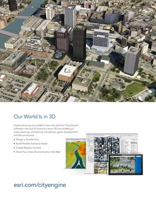
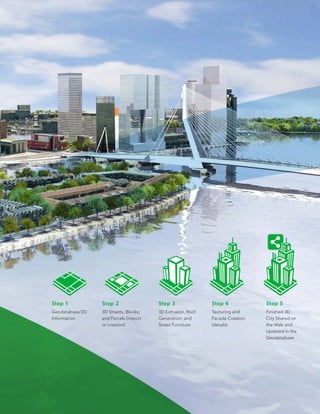
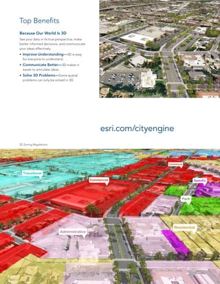
CityEngine software allows users to quickly create realistic 3D city models for applications such as urban planning, architecture, simulations, and film production. It features easy-to-use tools for sketching, texturing, and editing 3D building models. Models can be integrated with ArcGIS and shared online. CityEngine supports common 3D formats and its data can improve communication and understanding of 3D urban planning challenges.
This is presentation is intended for middle school students. It provides a short introduction to GIS and how to use GIS in the real-world.
ArcGIS Explorer is the software used to demonstrate concepts.
45 minutes + 15 minutes demo
Download ArcGIS Explorer here...
http://www.esri.com/software/arcgis/explorer/
This Seminar presentation is made by Shrikrishna Kesharwani
1ST YEAR, Transportation engineering student
NIT WARANGAL
FOLLOW ME ON INSTAGRAM
@SHRIKRISHNAKESHARWANI
Geodatabase: The ArcGIS Mechanism for Data ManagementEsri South Africa
This presentation is about understanding the content that goes into a geodatabase, advantages of using geodatabases, data management and maintaining data integrity.
3D GIS brings enhanced depth into data collection and analysis by incorporating a z-value into mapping. Most commonly, that means including elevation data, but users have many options for adding layers of information.
While 3D models are more difficult to create and maintain than 2D ones, there are myriad 3D GIS applications where this technology is greatly beneficial.
The 3D-GIS in the Cloud main purpose is to evaluate the use-efficiency of both existing and planned spatial space.
DEFINITION :
GIS is a powerful set of tools for collecting, storing , retrieving at will, transforming and displaying spatial data from the real world for a particular set of purposes
APPLICATION AREAS OF GIS
Agriculture
Business
Electric/Gas utilities
Environment
Forestry
Geology
Hydrology
Land-use planning
Local government
Mapping
11. Military
12. Risk management
13. Site planning
14. Transportation
15. Water / Waste water industry
COMPONENTS OF GIS
DATA INPUT
SPATIAL DATA MODEL
Data Model:
It describes in an abstract way how the data is represented in an information system or in DBMS
Spatial Data Model :
The models or abstractions of reality that are intended to have some similarity with selected aspects of the real world
Creation of analogue and digital spatial data sets involves seven levels of model development and abstraction
SPATIAL DATA MODEL
Conceptual model : A view of reality
Analog model : Human conceptualization leads to analogue abstraction
Spatial data models : Formalization of analogue abstractions without any conventions
Database model : How the data are recorded in the computer
Physical computational model : Particular representation of the data structures in computer memory
Data manipulation model : Accepted axioms and rules for handling the data
SPATIAL DATA MODEL
SPATIAL DATA MODEL
Objects on the earth surface are shown as continuous and discrete objects in spatial data models
Types of data models
Raster data model
vector data models
RASTER DATA MODEL
Basic Elements :
Extent
Rows
Columns
Origin
Orientation
Resolution: pixel = grain = grid cell
Ex: Bit Map Image (BMP),Joint Photographic Expert Group (JPEG), Portable Network Graphics(PNG) etc
RASTER DATA MODEL
VECTOR DATA MODEL
Basic Elements:
Location (x,y) or (x,y,z)
Explicit, i.e. pegged to a coordinate system
Different coordinate system (and precision) require different values
o e.g. UTM as integer (but large)
o Lat, long as two floating point numbers +/-
Points are used to build more complex features
Ex: Auto CAD Drawing File(DWG), Data Interchange(exchange) File(DXF), Vector Product Format (VPF) etc
VECTOR DATA MODEL
RASTER vs VECTORRaster is faster but Vector is corrector
TESSELLATIONS OF CONTINUOUS FIELDS
Triangular Irregular Network: (TIN)
TIN is a vector data structure for representing geographical information that is continuous
Digital elevation model
TIN is generally used to create Digital Elevation Model (DEM)
DIGITAL ELEVATION MODEL
DATA STRUCTURES
Data structure tells about how the data is stored
Data organization in raster data structures
Each cell is referenced directly
Each overlay Is referenced directly
Each mapping unit is referenced directly
Each overlay is separate file with general header
Getting It Done with limited staff, time and budget.
This slide show shares a process of developing a GIS plan and framework, shows tools to track and implement the plan, and shows examples of how the GIS plan is directly tied with City initiatives and budget.
Definition of map: diagrammatic representation of reality on a paper.
elements of a map: scale, direction, title, subtitle, ownership, key map, legend
contents of base map: boundaries
network, topography, landuse, contours, utilities
appropriate scales for various types of plan like regional plan, perspective plan, development plan, local area plan
measurement of sclaes: scale conversion from larger unit to smaller units and vice-versa
Landuse classification, Landuse Landcover (LULC) classification
Gis Geographical Information System FundamentalsUroosa Samman
Gis, Geographical Information System Fundamentals. This presentation includes a complete detail of GIS and GIS Softwares. It will help students of GIS and Environmental Science.
Mumbai University, T.Y.B.Sc.(I.T.), Semester VI, Principles of Geographic Information System, USIT604, Discipline Specific Elective Unit 1: Introduction to GIS
A geographic information system (GIS) is a system designed to capture, store, manipulate, analyze, manage, and present all types of geographical data. The acronym GIS is sometimes used for geographical information science or geospatial information studies to refer to the academic discipline or career of working with geographic information systems and is a large domain within the broader academic discipline of Geoinformatics. In the simplest terms, GIS is the merging of cartography, statistical analysis, and computer science technology.
GIS is a system of record and as such incredably valuable basis for design. In the Geodesign process, (3D) GIS technology is incredably powerful for visualizing and analyzing urban designs. Procedural modellng in CityEngine allows city planners and designers generate flexible designs that allow for manipulation of all design parameters. 3D GIS technology connects the real world as it is stored in a realistic model with the virtual worlds of the future designed with procedural modelling.
Esri CityEngine & Minecraft: Engaging Citizens in 3D City PlanningSafe Software
Researchers at VU, Amsterdam are leveraging Esri CityEngine and Minecraft to increase citizen engagement in neighborhood design & planning. Inspired by UN-Habitat’s Block by Block, the project combines 2D & 3D datasets to create a 3D model in CityEngine. This GIS output becomes a canvas of the city in Minecraft, offering a gaming-style geodesign tool that citizens and their children can interact with. This presentation will explore how 2D data can be leveraged in 3D with Esri CityEngine.
Esri CityEngine & Minecraft: Engaging Citizens in 3D City PlanningErin Lemky
Researchers at VU, Amsterdam are leveraging Esri CityEngine and Minecraft to increase citizen engagement in neighborhood design & planning. Inspired by UN-Habitat’s Block by Block, the project combines 2D & 3D datasets to create a 3D model in CityEngine. This GIS output becomes a canvas of the city in Minecraft, offering a gaming-style geodesign tool that citizens and their children can interact with. This presentation will explore how 2D data can be leveraged in 3D with Esri CityEngine.
Francisco Nobre, Public Safety Business Development Executive, and Anthony Giles, Solution Engineer, Esri – See what others can’t! Leveraging sensor data and the Internet of Things to improve agency response to disasters
Insights Success has compiled a list of “The 10 Most Promising Smart City Solution Providers, 2021”, which are reshaping the world with their cutting-edge solutions.
Create Minecraft Worlds with ArcGIS and the Data Interoperability ExtensionSafe Software
GIS professionals are experiencing excellent results combining GIS and gaming worlds such as Minecraft to engage wider and younger audiences to solve real problems. City planning, crisis management (floods, fires, etc.) and other tasks become fun and accessible to the public. Attendees will discover how to move IFC, Revit, CityEngine, and all kinds of other data through ArcGIS and into Minecraft using the ArcGIS Data Interoperability Extension. Implemented customer examples will be presented alongside strategies and tips, equipping attendees to implement these skills themselves.
Design For Digital and Physical Realities: Multi-Dimensional UXPreston McCauley
In this presentation, I give a brief overview of AR / VR and how ux designers can become multi-dimensional designers and begin to design for new forms of reality. I also give a brief rundown of some use cases across a few industries. Lastly, I share some tools for prototyping across these new design spaces.
INIA- CISA: Análisis de las amenazas en la fauna silvestreEsri
El Centro de Investigación en Sanidad Animal del Instituto Nacional de Investigación y Tecnología Agraria y Alimentaria utiliza la tecnología SIG para una mejor comprensión de las amenazas a las especies silvestres y su asociación con las actividades humanas
Builder.ai Founder Sachin Dev Duggal's Strategic Approach to Create an Innova...Ramesh Iyer
In today's fast-changing business world, Companies that adapt and embrace new ideas often need help to keep up with the competition. However, fostering a culture of innovation takes much work. It takes vision, leadership and willingness to take risks in the right proportion. Sachin Dev Duggal, co-founder of Builder.ai, has perfected the art of this balance, creating a company culture where creativity and growth are nurtured at each stage.
Generating a custom Ruby SDK for your web service or Rails API using Smithyg2nightmarescribd
Have you ever wanted a Ruby client API to communicate with your web service? Smithy is a protocol-agnostic language for defining services and SDKs. Smithy Ruby is an implementation of Smithy that generates a Ruby SDK using a Smithy model. In this talk, we will explore Smithy and Smithy Ruby to learn how to generate custom feature-rich SDKs that can communicate with any web service, such as a Rails JSON API.
GDG Cloud Southlake #33: Boule & Rebala: Effective AppSec in SDLC using Deplo...James Anderson
Effective Application Security in Software Delivery lifecycle using Deployment Firewall and DBOM
The modern software delivery process (or the CI/CD process) includes many tools, distributed teams, open-source code, and cloud platforms. Constant focus on speed to release software to market, along with the traditional slow and manual security checks has caused gaps in continuous security as an important piece in the software supply chain. Today organizations feel more susceptible to external and internal cyber threats due to the vast attack surface in their applications supply chain and the lack of end-to-end governance and risk management.
The software team must secure its software delivery process to avoid vulnerability and security breaches. This needs to be achieved with existing tool chains and without extensive rework of the delivery processes. This talk will present strategies and techniques for providing visibility into the true risk of the existing vulnerabilities, preventing the introduction of security issues in the software, resolving vulnerabilities in production environments quickly, and capturing the deployment bill of materials (DBOM).
Speakers:
Bob Boule
Robert Boule is a technology enthusiast with PASSION for technology and making things work along with a knack for helping others understand how things work. He comes with around 20 years of solution engineering experience in application security, software continuous delivery, and SaaS platforms. He is known for his dynamic presentations in CI/CD and application security integrated in software delivery lifecycle.
Gopinath Rebala
Gopinath Rebala is the CTO of OpsMx, where he has overall responsibility for the machine learning and data processing architectures for Secure Software Delivery. Gopi also has a strong connection with our customers, leading design and architecture for strategic implementations. Gopi is a frequent speaker and well-known leader in continuous delivery and integrating security into software delivery.
Key Trends Shaping the Future of Infrastructure.pdfCheryl Hung
Keynote at DIGIT West Expo, Glasgow on 29 May 2024.
Cheryl Hung, ochery.com
Sr Director, Infrastructure Ecosystem, Arm.
The key trends across hardware, cloud and open-source; exploring how these areas are likely to mature and develop over the short and long-term, and then considering how organisations can position themselves to adapt and thrive.
Kubernetes & AI - Beauty and the Beast !?! @KCD Istanbul 2024Tobias Schneck
As AI technology is pushing into IT I was wondering myself, as an “infrastructure container kubernetes guy”, how get this fancy AI technology get managed from an infrastructure operational view? Is it possible to apply our lovely cloud native principals as well? What benefit’s both technologies could bring to each other?
Let me take this questions and provide you a short journey through existing deployment models and use cases for AI software. On practical examples, we discuss what cloud/on-premise strategy we may need for applying it to our own infrastructure to get it to work from an enterprise perspective. I want to give an overview about infrastructure requirements and technologies, what could be beneficial or limiting your AI use cases in an enterprise environment. An interactive Demo will give you some insides, what approaches I got already working for real.
The Art of the Pitch: WordPress Relationships and SalesLaura Byrne
Clients don’t know what they don’t know. What web solutions are right for them? How does WordPress come into the picture? How do you make sure you understand scope and timeline? What do you do if sometime changes?
All these questions and more will be explored as we talk about matching clients’ needs with what your agency offers without pulling teeth or pulling your hair out. Practical tips, and strategies for successful relationship building that leads to closing the deal.
Securing your Kubernetes cluster_ a step-by-step guide to success !KatiaHIMEUR1
Today, after several years of existence, an extremely active community and an ultra-dynamic ecosystem, Kubernetes has established itself as the de facto standard in container orchestration. Thanks to a wide range of managed services, it has never been so easy to set up a ready-to-use Kubernetes cluster.
However, this ease of use means that the subject of security in Kubernetes is often left for later, or even neglected. This exposes companies to significant risks.
In this talk, I'll show you step-by-step how to secure your Kubernetes cluster for greater peace of mind and reliability.
JMeter webinar - integration with InfluxDB and GrafanaRTTS
Watch this recorded webinar about real-time monitoring of application performance. See how to integrate Apache JMeter, the open-source leader in performance testing, with InfluxDB, the open-source time-series database, and Grafana, the open-source analytics and visualization application.
In this webinar, we will review the benefits of leveraging InfluxDB and Grafana when executing load tests and demonstrate how these tools are used to visualize performance metrics.
Length: 30 minutes
Session Overview
-------------------------------------------
During this webinar, we will cover the following topics while demonstrating the integrations of JMeter, InfluxDB and Grafana:
- What out-of-the-box solutions are available for real-time monitoring JMeter tests?
- What are the benefits of integrating InfluxDB and Grafana into the load testing stack?
- Which features are provided by Grafana?
- Demonstration of InfluxDB and Grafana using a practice web application
To view the webinar recording, go to:
https://www.rttsweb.com/jmeter-integration-webinar
Elevating Tactical DDD Patterns Through Object CalisthenicsDorra BARTAGUIZ
After immersing yourself in the blue book and its red counterpart, attending DDD-focused conferences, and applying tactical patterns, you're left with a crucial question: How do I ensure my design is effective? Tactical patterns within Domain-Driven Design (DDD) serve as guiding principles for creating clear and manageable domain models. However, achieving success with these patterns requires additional guidance. Interestingly, we've observed that a set of constraints initially designed for training purposes remarkably aligns with effective pattern implementation, offering a more ‘mechanical’ approach. Let's explore together how Object Calisthenics can elevate the design of your tactical DDD patterns, offering concrete help for those venturing into DDD for the first time!
3. Create stunning city models in less time with Esri®
City Engine®
software—the tool of choice for smart 3D city modeling in
urban planning, architecture, simulations, game development,
and film production.
• Design a Smarter City
• Build Flexible Scenarios Faster
• Create Realistic Context
• Share Your Urban Environment on the Web
Our World Is in 3D
esri.com/cityengine
5. Step 5
Finished 3D
City Shared on
the Web and
Updated in the
Geodatabase
Step 4
Texturing and
Facade Creation
(details)
Step 2
3D Streets, Blocks,
and Parcels (import
or creation)
Step 3
3D Extrusion, Roof
Generation, and
Street Furniture
Step 1
Geodatabase/2D
Information
6. 3D Zoning Regulations
Because Our World Is 3D
See your data in its true perspective, make
better informed decisions, and communicate
your ideas effectively.
• Improve Understanding—3D is easy
for everyone to understand.
• Communicate Better—3D makes it
easier to articulate ideas.
• Solve 3D Problems—Some spatial
problems can only be solved in 3D.
esri.com/cityengine
Top Benefits
7. Easy-to-Use Editing Tools
Get easy-to-use editing tools for quick sketching and
texturing of 3D building models.
Integrated with ArcGIS
CityEngine fully supports the Esri file geodatabase
(including textured multipatches) and the shapefile
format. Users can import/export any geospatial
vector data.
Instant Report Generation
To compare planning proposals and analyze designs,
customized rule-based reports can be generated to
automatically calculate quantities such as density or
grow floor area.
Share Smart 3D City Scenes
CityEngine scenes can be published directly on the
web for sharing 3D models, analysis results, or design
proposals with decision makers or the public.
Industry-Standard 3D Formats
CityEngine supports KML, COLLADA, Autodesk®
FBX®
, Wavefront OBJ, DXF, or RenderMan®
RIB for
3D data exchange. FBX and COLLADA support
advanced material handling, asset instancing, and
multiple UV sets.
Training Materials
Architects, urban planners, GIS professionals, game
developers, and computer graphic artists can avail
themselves of several videos and tutorials that show
the basics and key concepts of CityEngine. Sample
projects of ancient, contemporary, and future cities at
different levels of detail are also available.
Available for All Platforms
CityEngine is available for Windows®
(64 bit), Mac®
OS X (64 bit), and Linux®
(64 bit).
Data Model Templates for Cities
Esri provides harmonized information models of 3D
GIS datasets that bring local government operations
to life for city staff and citizens. With CityEngine,
these datasets—including uniquely customizable
zoning regulations—can be visualized, edited, and
shared in 3D.
Features