Soil Atlas of Asia: Indonesia
•Download as PPT, PDF•
1 like•107 views

The document discusses soil priorities and available soil information for Indonesia at the national and regional levels. At the national level, key priorities include peat soil distribution, erosion, and degradation from mining. Soil maps at scales of 1:1,000,000, 1:1,250,000, and 1:50,000 are available digitally, along with reports and derivative maps. Regionally, priorities include peat soils, nutrients, and erosion, while maps at 1:1,000,000 and 1:1,250,000 scales and reports in local languages are available. The document provides an overview of soil data and issues for Indonesia to inform an atlas.
Recommended

More Related Content
What's hot
What's hot (20)
Similar to Soil Atlas of Asia: Indonesia
Similar to Soil Atlas of Asia: Indonesia (20)
More from ExternalEvents
More from ExternalEvents (20)
Recently uploaded
Recently uploaded (20)
Soil Atlas of Asia: Indonesia
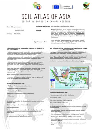
- 1. Soil priorities at the national level: Surface areas affected by the identified soil threats and actions taken to address them. Thickness of peat soils and their distribution Peat moisture regime Serious degradation of ecosystem (loss diversity, degraded soils, lot of ponds and exposed of pyrite resulted extreme low soil pH in post mining areas Soil erosions, especially sloping areas. Conservation associated with the easy acceptance and application by farmers Experience as editor: Soil priorities at the regional level: Thickness of peat soils and their distribution Soil nutrient status soil erosion associated with sloping areas Soil salinity and acid sulfate soils Thickness of peat soils and their distribution (Malaysia, Brunai, Papua New Guinea) Soil nutrient status (Asian countries with high annual rainfall) Sloping areas (Asian countries with high annual rainfall) Soil erosion. Soil conservation practices conventional and modern agricultural practices Soil salinity and acid sulfate soils (Asian countries having coastal areas Surface area affected by the identified priorities and countries they interest the most. Soil Information that can be made available for the Atlas at the national level. Soil map at 1:1.000.000 scale produced by 2000 by compiling the existing soil maps (1962-2000) and used for general overview of Indonesian soil distribution (available in digital form) Soil map at 1:1.250.000 scale produced mostly by 2010 (1980-2015) with updating and revision and available in digital forms for all Indonesian areas Soil map at 1:1.50.000 produced mostly by 2016-2017 (1980-2017) some areas are still in progress (about 25% = 129 districts) of Indonesian areas, with updating and revision and available in digital forms Soils in all maps were classified according to Soil Survey Staff (various editions, 1998-2014). Classifications at the Order category for exploratory scale, at great group for 1:250.000 and at subgroup for 1:50.000 scale Soil survey reports in Indonesian language Derivative soil maps such as land evaluation maps for agricultural crops and management recommendation Thickness of peat soils and their distribution Soil nutrient status (low organic C) Various mining land/soils Soil physical, chemical and biological degradation Soil erosion Soil Information that can be made available for the Atlas at the regional level. Soil map at 1:1.000.000 scale produced by 2000 by compilation of existing soil maps (1962-2000) and available in digital form Soil map at 1:1.250.000 produced mostly by 2010 (1980-2015) results of soil map updating and available in digital forms for all Indonesian areas (need correlation and verification of mapping units) Soil survey reports need translation into International languages Network: Name of the presenter: Main areas of expertise: Country: MARKUS ANDA INDONESIA Editor in chief of Indonesian journal of agricultural sciences, editor of national proceedings, books and reports and International proceeding of Globalsoilmap.net National: Involving in soil mapping and land evaluation to provide soil information and recommendation for government officers at various provinces and National as a basis to make grand design of spatial land use planning. International: Host of International conference of Global soilmap.net Oceania node; Attend International congress of Universal soil classification Soil mineralogy, classification and mapping EXPLORATORY SOIL MAP OF INDONESIAKalimantanKalimantan JawaJawa SulawesiSulawesi PapuaPapua SumateraSumatera NTTNTT MalukuMaluku BaliBali LegendLegend