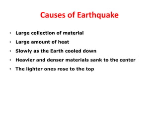
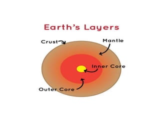
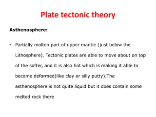
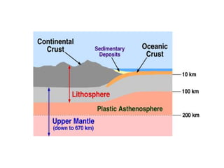
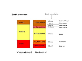
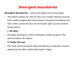
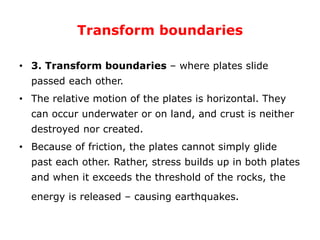
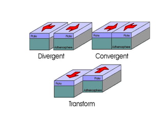
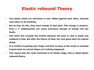
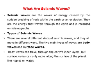
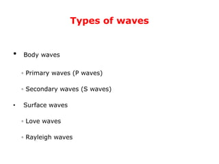
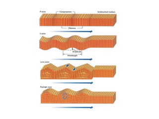
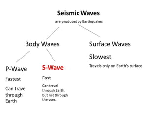
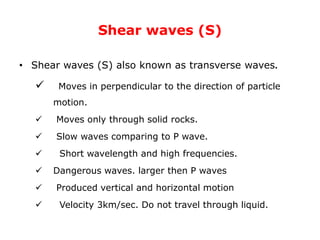
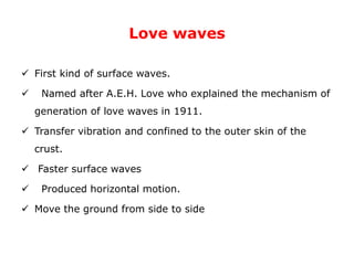
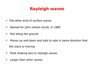
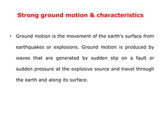
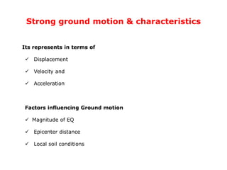
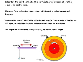
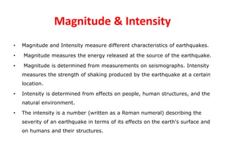
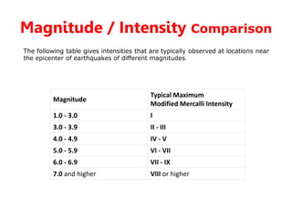
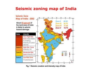
This document discusses elements of seismology and earthquake engineering. It covers topics such as causes of earthquakes including plate tectonic theory, elastic rebound theory, types of seismic waves, measurement of earthquakes through seismographs, magnitude and intensity scales, and characteristics of strong ground motion. Key concepts are the different types of plate boundaries that can cause earthquakes, as well as the different types of seismic waves like P, S, love, and rayleigh waves that radiate from earthquake sources.
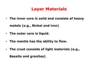
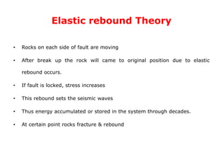
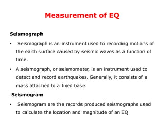
Online blood donation management system project.pdf
unit iii ppt.pptx
1. CE6701
STRUCTURAL DYNAMICS AND EARTHQUAKE
ENGINEERING
UNIT III ELEMENTS OF SEISMOLOGY
Elements of Engineering Seismology
Causes of Earthquake
Plate Tectonic theory
Elastic rebound Theory
Characteristic of earthquake
Estimation of earthquake parameters
Magnitude and intensity of earthquakes
Spectral Acceleration
M.perarasan, AP/Civil, AIT
2. Seismology
• Seismology is the scientific study of earthquakes and the
propagation of elastic waves through the Earth or through
other planet-like bodies. The field also includes studies of
earthquake effects, such as tsunamis as well as
diverse seismic sources such as volcanic, tectonic, oceanic,
atmospheric, and artificial processes (such as explosions)
3. Earthquake
• Sudden vibration movement of earth's surface
• Release of energy in the earth's crust.
• Vibration of the ground produced by forces called seismic
forces
4. Causes of Earthquake
• Large collection of material
• Large amount of heat
• Slowly as the Earth cooled down
• Heavier and denser materials sank to the center
• The lighter ones rose to the top
5.
6. • The Earth is made of four basic layers
• Inner core (radius ~1290km)
• The outer core (thickness ~2200km)
• The mantle (thickness ~2900km)
• The crust (thickness ~5 to 40km)
7. Layer Materials
• The inner core is solid and consists of heavy
metals (e.g., Nickel and iron)
• The outer core is liquid.
• The mantle has the ability to flow.
• The crust consists of light materials (e.g.,
Basalts and granites)
8. Main causes of Earthquake
1. Natural sources
– a. Tectonic EQ
– b. Volcanic EQ
– c. Rock faults
2. Man made sources
– a. Controlled sources (explosives)
– b. Reservoir induced EQ
– c. Mining induced EQ
9. 1.Plate tectonic theory
A major plate is any plate with an area greater than 20 millionkm².
• African Plate.
• Antarctic Plate.
• Eurasian Plate.
• Indo-Australian Plate.
• North American Plate.
• Pacific Plate.
• South American Plate.
11. What are Tectonic plates
The Earth’s crust consists of about a dozen large slabs of rock, or
PLATES, that the continents and oceans rest on. These tectonic
plates can move centimetres per year
Earth’s Sub layers
Lithosphere:
• This layer combines the rigid crust plus the upper-most mantle.
• The Lithosphere is also slightly elastic. It is flexed when things are places
on it or removed from it. The Lithosphere is also known as the brittle outer
layer of the solid Earth.
12. Plate tectonic theory
Asthenosphere:
• Partially molten part of upper mantle (just below the
Lithosphere). Tectonic plates are able to move about on top
of the softer, and it is also hot which is making it able to
become deformed(like clay or silly putty).The
asthenosphere is not quite liquid but it does contain some
melted rock there
13.
14.
15. Plate tectonic theory
• Tectonic plates are also called lithospheric plates because
the crust and the upper-most mantle make up a sub-layer
of the earth called the lithosphere. The plates can move
about because the uppermost mantle, or the
asthenosphere, is partially molten and possesses a physical
property called plasticity, allowing the strong, rigid plates of
the crust to move over the weaker, softer asthenosphere.
16. Plate tectonic theory
• Tectonic plates, or lithospheric plates, are constantly moving,
being created, and consumed simultaneously. The motion
sometimes results in earthquakes, volcanoes, and mountain
ranges at the plate boundaries.
• Plate motion is driven by heat escaping from the mantle. The
constant movement of heat in the mantle leads to circular
convection currents. These hot convective cells are similar to
the rolling boil that occurs when water is heated on a stovetop.
The flowing mantle has also been compared to a “conveyor
belt,” moving the rigid plates in different directions.
17. Plate Boundaries
• There are three basic ways that plates interact with one
another. Each of these plate boundaries has the potential
to create different geological features. Plate Boundaries
• Divergent plate boundaries: the two plates move away
from each other.
• Convergent plate boundaries: the two plates move
towards each other.
• Transform plate boundaries: the two plates slip past
each other.
18. Convergent boundaries
• Convergent boundaries: where two plates are colliding.
• Subduction zones occur when one or both of the tectonic
plates are composed of oceanic crust. The denser plate is
subducted underneath the less dense plate. The plate being
forced under is eventually melted and destroyed.
19. Convergent boundaries
i. Where oceanic crust meets ocean crust
• Island arcs and oceanic trenches occur when both of the plates
are made of oceanic crust. Zones of active seafloor spreading can
also occur behind the island arc, known as back-arc basins. These
are often associated with submarine volcanoes.
ii. Where oceanic crust meets continental crust
• The denser oceanic plate is subducted, often forming a mountain
range on the continent. The Andes is an example of this type of
collision.
• iii. Where continental crust meets continental crust
• Both continental crusts are too light to subduct so a continent-
continent collision occurs, creating especially large mountain
ranges. The most spectacular example of this is the Himalayas.
20. Divergent boundaries
Divergent boundaries – where two plates are moving apart.
• The space created can also fill with new crustal material sourced
from molten magma that forms below. Divergent boundaries can
form within continents but will eventually open up and become
ocean basins.
i. On land
• Divergent boundaries within continents initially produce rifts,
which produce rift valleys.
ii. Under the sea
• The most active divergent plate boundaries are between oceanic
plates and are often called mid-oceanic ridges.
21. Transform boundaries
• 3. Transform boundaries – where plates slide
passed each other.
• The relative motion of the plates is horizontal. They
can occur underwater or on land, and crust is neither
destroyed nor created.
• Because of friction, the plates cannot simply glide
past each other. Rather, stress builds up in both plates
and when it exceeds the threshold of the rocks, the
energy is released – causing earthquakes.
22.
23. Elastic rebound Theory
• Two plates which are enormous in size. Slides against each other, towards
each other or do anything.
• But as they do this, they store energy at that joint. This energy is massive.
Even a 1" displacement can cause enormous storage of energy into the
faults.
• And when this exceeds the friction between the joint or rock it snaps and
suddenly it fails. But after the failure of fault, the rock gains back its original
shape.
• It is similar to pushing your finger and then as soon as the stress is released
it gains back its normal shape as if nothing happened.
• This means that the rocks remained in its elastic stage, this is called elastic
rebound theory.
24. Elastic rebound Theory
• Rocks on each side of fault are moving
• After break up the rock will came to original position due to elastic
rebound occurs.
• If fault is locked, stress increases
• This rebound sets the seismic waves
• Thus energy accumulated or stored in the system through decades.
• At certain point rocks fracture & rebound
25. Volcanic Earthquake
• Hot magma moves slowly through underground passages
under pressure.
• More damage and intensity waves are produced
• Rock take pressure when the magma came out
• The EQ will occurred due to this action
26. Volcanic Earthquake
• A volcano is a mountain that opens downward to a pool of molten
rock below the surface of the earth. When pressure builds up,
eruptions occur. Gases and rock shoot up through the opening and
spill over or fill the air with lava fragments. Eruptions can cause
lateral blasts, lava flows, hot ash flows, mudslides, avalanches, falling
ash and floods. Volcano eruptions have been known to knock down
entire forests. An erupting volcano can trigger tsunamis, flash floods,
earthquakes, mudflows and rockfalls
27. Rock Fault
• A fault is a crack in the Earth's crust. Typically, faults are
associated with, or form, the boundaries between Earth's
tectonic plates. In an active fault, the pieces of the Earth's
crust along a fault move over time. The moving rocks can
cause earthquakes. Inactive faults had movement along
them at one time, but no longer move. The type of motion
along a fault depends on the type of fault.
28. Rock Fault
Based on the direction of movement of blocks, 3 types
1. Dip-Slip fault
– Normal fault
– Reverse fault
2. Strike-Slip fault
3. Oblique-Slip fault
29. Rock Fault
• Normal dip-slip fault
– Normal faults happen in areas where the rocks are
pulling apart (tensile forces) so that the rocky crust of
an area is able to take up more space.
– The rock on one side of the fault is moved down relative
to the rock on the other side of the fault.
– Normal faults will not make an overhanging rock ledge.
– In a normal fault it is likely that you could walk on an
exposed area of the fault.
30. Rock Fault
• Reverse dip-slip fault
– Reverse faults happen in areas where the rocks are pushed together
(compression forces) so that the rocky crust of an area must take up
less space.
– The rock on one side of the fault is pushed up relative to rock on the
other side.
– In a reverse fault the exposed area of the fault is often an overhang.
Thus you could not walk on it.
– Thrust faults are a special type of reverse fault. They happen when the
fault angle is very low.
31. Rock Fault
• Transform (strike-slip) faults
– The movement along a strike slip fault is horizontal with the block
of rock on one side of the fault moving in one direction and the
block of rock along the other side of the fault moving in the other
direction.
– Strike slip faults do not make cliffs or fault scarps because the
blocks of rock are not moving up or down relative to each other.
An oblique fault combines elements of a dip-slip fault and a
strike-slip fault.
33. Controlled sources (explosives)
• ◦ Human produced EQ, like nuclear devices.
• ◦ Moderately create damage 50km away.
• ◦ Rock blasting in quarries also produced small seismic EQ.
34. Reservoir induced EQ
• Weight of the water increased pressure of rock below the
valley surface.
• Rupture of rock.
example : Koyna Dam (magnitude 6.5)
Mining EQ
• Underground caves and mine collapse
35. What Are Seismic Waves?
• Seismic waves are the waves of energy caused by the
sudden breaking of rock within the earth or an explosion. They
are the energy that travels through the earth and is recorded
on seismographs.
• Types of Seismic Waves
• There are several different kinds of seismic waves, and they all
move in different ways. The two main types of waves are body
waves and surface waves.
• Body waves can travel through the earth's inner layers, but
surface waves can only move along the surface of the planet
like ripples on water.
36. Types of waves
• Body waves
◦ Primary waves (P waves)
◦ Secondary waves (S waves)
• Surface waves
◦ Love waves
◦ Rayleigh waves
37.
38.
39. Primary waves (P waves)
• Primary waves (P waves)
These are longitudinal waves similar to sound waves
fastest of seismic waves.
P waves can move through solid rocks and fluids.
Also known as compression waves because of pushing
and pulling action. Particles moves in same direction.
Velocity of the waves is 4.8km/sec.
Shortest wavelength and high frequencies.
Sometimes animals can hear the P-Waves EQ
40. Shear waves (S)
• Shear waves (S) also known as transverse waves.
Moves in perpendicular to the direction of particle
motion.
Moves only through solid rocks.
Slow waves comparing to P wave.
Short wavelength and high frequencies.
Dangerous waves. larger then P waves
Produced vertical and horizontal motion
Velocity 3km/sec. Do not travel through liquid.
41. Love waves
First kind of surface waves.
Named after A.E.H. Love who explained the mechanism of
generation of love waves in 1911.
Transfer vibration and confined to the outer skin of the
crust.
Faster surface waves
Produced horizontal motion.
Move the ground from side to side
42. Rayleigh waves
The other kind of surface waves.
Named for john william strutt, in 1885
Roll along the ground
Moves up and down and side to side in same direction that
the wave is moving
Most shaking due to rayleigh waves.
Larger then other waves.
43. Measurement of EQ
Seismograph
• Seismograph is an instrument used to recording motions of
the earth surface caused by seismic waves as a function of
time.
• A seismograph, or seismometer, is an instrument used to
detect and record earthquakes. Generally, it consists of a
mass attached to a fixed base.
Seismogram
• Seismogram are the records produced seismographs used
to calculate the location and magnitude of an EQ
46. Strong ground motion & characteristics
• Ground motion is the movement of the earth's surface from
earthquakes or explosions. Ground motion is produced by
waves that are generated by sudden slip on a fault or
sudden pressure at the explosive source and travel through
the earth and along its surface.
47. Strong ground motion & characteristics
Its represents in terms of
Displacement
Velocity and
Acceleration
Factors influencing Ground motion
Magnitude of EQ
Epicenter distance
Local soil conditions
48. Epicenter-The point on the Earth's surface located directly above the
focus of an earthquake.
Distance from epicenter to any point of interest is called epicentral
distance
Focus-The location where the earthquake begins. The ground ruptures at
this spot, then seismic waves radiate outward in all directions
The depth of focus from the epicenter, called as Focal Depth
49. Magnitude & Intensity
• Magnitude and Intensity measure different characteristics of earthquakes.
• Magnitude measures the energy released at the source of the earthquake.
• Magnitude is determined from measurements on seismographs. Intensity
measures the strength of shaking produced by the earthquake at a certain
location.
• Intensity is determined from effects on people, human structures, and the
natural environment.
• The intensity is a number (written as a Roman numeral) describing the
severity of an earthquake in terms of its effects on the earth's surface and
on humans and their structures.
50. Magnitude / Intensity Comparison
Magnitude
Typical Maximum
Modified Mercalli Intensity
1.0 - 3.0 I
3.0 - 3.9 II - III
4.0 - 4.9 IV - V
5.0 - 5.9 VI - VII
6.0 - 6.9 VII - IX
7.0 and higher VIII or higher
The following table gives intensities that are typically observed at locations near
the epicenter of earthquakes of different magnitudes.
52. Date Location Mag. I Deaths Injuries
Total damage /
notes
2017-01-03 India, Bangladesh 5.7 Mw V 3 8
2016-01-04
India, Myanmar,
Bangladesh
6.7 Mw VII 11 200
2015-10-26
Afghanistan, India
, Pakistan
7.7 Mw VII 399 2,536
2015-05-12 Nepal, India 7.3 Mw VIII 218 3,500+
2015-04-25 Nepal, India 7.8 Mw IX 8,964 21,952 $10 billion
2013-05-01 Kashmir 5.7 Mw 3 90 $19.5 million NGDC
2011-09-18 Gangtok, Sikkim 6.9 Mw VII >111
2009-08-10 Andaman Islands 7.5 Mw VIII
Tsunami warning
issued
2008-02-06 West Bengal 4.3 Mb 1 50
Buildings
damaged
NGDC
2007-11-06 Gujarat 5.1 Mw V 1 5
Buildings
damaged
[2]
2006-11-29
Alwar
district, Rajasthan
4.0 Mw 1 2
Minor damage to
property and at
least one death
[3]
2006-03-07 Gujarat 5.5 Mw VI 7
Buildings
damaged
[4]
2006-02-14 Sikkim 5.3 Mw V 2 2 Landslide [5]
2005-12-14 Uttarakhand 5.1 Mw VI 1 3
Building
destroyed
[6]
2005-10-08 Kashmir 7.6 Mw VIII 86,000–87,351 69,000–75,266
2.8 million
displaced
2004-12-26
off northern
Sumatra
9.1–9.3 Mw IX 227,898
Destructive
tsunami, 16,269
fatalities in India
2002-09-13 Andaman Islands 6.5 Mw 2
Destructive
tsunami
NGDC
2001-01-26 Gujarat 7.7 Mw X 13,805–20,023 ~166,800
1999-03-29
Chamoli district-
Uttarakhand
6.8 Mw VIII ~103
1997-11-21 Bangladesh, India 6.1 Mw 23 200
1997-05-22
Jabalpur, Madhya
Pradesh
5.8 Mw VIII 38–56 1,000–1,500 $37–143 million
List of earthquakes in India