The presentation discusses the evolution and significance of spatial data infrastructure (SDI) over the past 30 years, highlighting Canada's role and lessons learned from international initiatives. It emphasizes the shift from centralized data systems to decentralized networks, the challenges posed by evolving technologies, and the emergence of new data sources, including unmanned aerial vehicles. The GSDI Association aims to enhance global accessibility to geographic information, promoting collaboration and standardization to support diverse user needs.


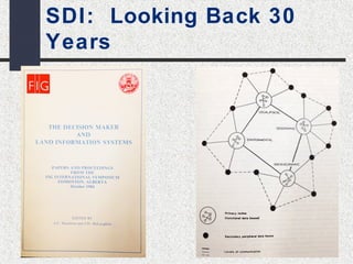


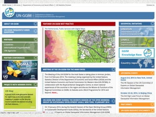
![Slide courtesy Google/Arabu [2013]](https://image.slidesharecdn.com/pancdnsdicolemansept172014-141002051717-phpapp01/85/David-Coleman-presentation-at-SDI-Summit-2014-Calgary-Canada-17-19-Sept-2014-16-320.jpg)
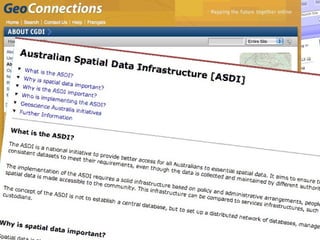
![Managing the Data
Resource
By 2013,
5 EXABYTES
was created
EVERY 10
MINUTES
From the
beginning of
recorded time until
2003, we created
5 EXABYTES
of Textual Data
In 2011,
5 EXABYTES of
all digital data
was created
EVERY TWO
DAYS
[Enriquez 2003/ Schmidt 2010/ Borne 2013]](https://image.slidesharecdn.com/pancdnsdicolemansept172014-141002051717-phpapp01/85/David-Coleman-presentation-at-SDI-Summit-2014-Calgary-Canada-17-19-Sept-2014-17-320.jpg)