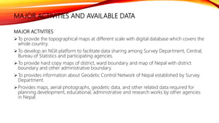
To describe the which organization management spatial data and objective as well as available data description. also include the challenges, advantage of SDI etc.
This presentation provides an overview of Land Information Systems (LIS). It discusses that a LIS is a digital system that contains both spatial and non-spatial land data. It then reviews the background of LIS in Western countries and how they differ from Nepal's system. The presentation outlines the key concepts of LIS including its methodology, current problems, and future planning. It aims to introduce LIS and provide context around its use and development in Nepal.
This document provides an overview of a presentation on Land Information Systems (LIS) given to Er. Subash Ghimire. The presentation was prepared by 5 students and covered the introduction of LIS, why they are important, background on LIS concepts in Western countries and Nepal, problems implementing LIS in Nepal, methodology, findings from data analysis in Land Revenue and District Survey Offices, challenges and future strategies. Key points included components of LIS, issues with incomplete data entry and updating in Nepal, and goals of moving to more accurate boundary representation and real-time access over time.
The document discusses Land Information Systems (LIS), which are Geographic Information Systems that contain cadastral and land use data. A LIS contains accurate, current, and reliable land records and associated attributes. It maintains both spatial and non-spatial data for each land parcel digitally, allowing edits and updates with minimal effort. The document outlines the Western concept of LIS, how LIS are implemented around the world, and proposes developing a LIS for Sri Lanka by integrating land parcel data into a Land Data Infrastructure to help manage municipalities.
Land information system for efficient lands administration and revenue genera...Alexander Decker
The document summarizes a study that developed a land information system for Trans-Amadi Industrial Layout in Port Harcourt, Nigeria. Existing land records and a layout plan were converted to digital formats using software like AutoCAD and ArcGIS. A database was created in MS Access to store spatial and attribute data for parcels. Queries and analysis were performed on the database to demonstrate how the system could support efficient land administration and revenue generation. The results showed ownership information, identified properties by number, determined land use and rents owed. Overall, the land information system provided a tool to facilitate management of land transactions and collection of land revenues.
This document provides an overview of land information systems (LIS) with a focus on India. It discusses the components and purpose of LIS, provides historical background on land administration systems in Western countries and India, and reviews examples of LIS implementation internationally and within states in India. Key components of LIS discussed include spatial and non-spatial data, cadastral mapping, and land records. The benefits of LIS for land management are also summarized.
This document discusses land administration and the role of GIS. It describes how land administration involves recording ownership and other attributes of land. GIS helps with land administration by providing digital maps and data for tasks like land registration, valuation for taxation, planning, and dispute resolution. The document also presents a case study of a GIS-based land information system developed for rural areas in India, which digitized paper maps, integrated satellite imagery, and allowed for more accurate planning and management of land use.
Status and Perspectives of GIS Application in BANGLADESHBayes Ahmed
This is the final presentation of the course GIS Applications in Developing Countries. This course was a part of the Erasmus Mundus Master in Geospatial Technologies offered in Westfälische Wilhelms-Universität Münster (WWU), Institute for Geoinformatics (ifgi), Münster, Germany.
The series of presentations contains the information about "Management Information System" subject of SEIT for University of Pune.
Subject Teacher: Tushar B Kute (Sandip Institute of Technology and Research Centre, Nashik)
http://www.tusharkute.com
GIS Data Availability in Bangladesh_FinalRazimulseye
The document summarizes geospatial data availability and GIS capacity in Bangladesh. It outlines common datasets like administrative boundaries up to the upazila level, populated places, transportation networks, and hydrology available from government agencies. Project-specific malaria data includes cases, LLIN and ACT distribution, and health facilities at the upazila level or below. Climate and population data is also available. Some data has coordinates and some does not. Important free spatial data websites for Bangladesh data are also listed.
This document discusses applications of geographic information systems (GIS) including urban planning, 3D modeling, environmental analysis, and hydrocarbon exploration. It provides examples of how GIS has been used for urban planning tasks like siting a daycare, modeling population change, and analyzing transportation networks. 3D modeling applications include generating high-resolution digital models from laser scanning data for uses like mapping, education, and engineering. Environmental analysis examples include examining the relationship between toxic sites and disadvantaged communities. The document also discusses GIS applications in hydrocarbon exploration like mapping fields and reservoirs, seismic interpretation, and production analysis to optimize resource development.
Empowering institutions and stakeholders for spatial planning - Dr. Nagaraj R...NeGD Capacity Building
1. The document discusses geospatial technologies for decentralized planning and governance in India. It outlines several projects using satellite imagery and geospatial data to support planning at various administrative levels from panchayats to districts.
2. Key projects include generating high resolution satellite maps and thematic layers for planning, creating geospatial databases, and developing a web portal to provide access to data and build capacity for its use in local governance.
3. The status of data generation and mapping efforts for various states is summarized, including generation of digital elevation models, satellite imagery products, thematic maps, and cadastral map overlays.
Remote Sensing Applications in Agriculture at the USDA National Agricultural...Phongsakorn Uar-amrungkoon
The mission of the National Agricultural Statistics Service (NASS), an agency of the United States Department of Agriculture (USDA) is “
to provide timely, accurate and useful statistics in service to US agriculture”. Towards this goal, NASS conducts hundreds of surveys every year collecting information on virtually every aspect of agricultural activity. In 2010, the NASS Cropland Data Layer
(CDL) Program played an important role toward fulfilling this mission using remote sensing techniques to provide operational in-season acreage estimates to the NASS Agricultural Statistics Board (ASB)
and Field Offices (FOs) for twenty seven states and sixteen crops.
The document discusses NIC's Geomatics Division in Madhya Pradesh and its work on developing state-wide GIS applications and infrastructure. It notes that G-governance based on spatial data is increasing, and that high resolution satellite imagery and more mature web-based software platforms enable more advanced geo-processing and management of large geospatial data. It then summarizes several key statewide enterprise GIS applications developed by the division and lists committees it contributes expertise to.
This document summarizes the National Spatial Data Infrastructure (NSDI) Initiative in India. It discusses the vision and objectives of NSDI to develop a national infrastructure for spatial data access and use at various governmental levels. It outlines current problems with data storage, services, and standards. Recent progress is noted in policies, data sharing guidelines, foundational datasets, and state-level SDI projects. Technical standards and architectures being used by NSDI are also summarized.
The document summarizes the current state of GIS within the County of Hawaii government. It outlines that 21 county departments currently use GIS data, though only 5 have designated GIS positions. It then lists over 30 types of geospatial data that are shared between departments and with the public through various online portals. The vision outlined is to create an enterprise GIS system with a unified platform to efficiently share and disseminate standardized data both internally and with the public through web and mobile applications and ArcGIS Online. This would improve the county's use of spatial data across departments.
The document discusses the purpose and functionalities of an Information Management System (IMS) to support transboundary groundwater governance. The IMS will collect, store, visualize and share structured groundwater information such as indicators, parameters, maps, documents and images. It will allow users to generate new information by combining and overlaying thematic maps, and support interpreted data and documents for transboundary groundwater management. The document outlines the roles of different actors in the data flow process including national experts, regional coordinators and IGRAC in collecting, processing, harmonizing and facilitating the sharing of data and information through the IMS.
This document provides an overview of geography awareness week and GIS. It discusses what GIS is, including how it can be used as a geodatabase, for geovisualization, and spatial analysis. It then discusses several applications of GIS in areas such as natural resource management, emergency response, social science, history, and trends in online GIS, cloud/mobile GIS, 3D-GIS, and volunteered geographic information.
This is presentation is intended for middle school students. It provides a short introduction to GIS and how to use GIS in the real-world.
ArcGIS Explorer is the software used to demonstrate concepts.
45 minutes + 15 minutes demo
Download ArcGIS Explorer here...
http://www.esri.com/software/arcgis/explorer/
Presentation prepared for Ikatan Ahli Perencana, Jakata (Planner Association). A lesson learn from Australia's and Indonesia's city. It shows case different implementation in Australia and Indonesia.
The document provides an overview of geographical information systems (GIS). It defines GIS as a system for capturing, storing, manipulating, analyzing and presenting spatial or geographic data. It describes the core components of GIS as hardware, software, data, people and methods. It outlines several applications of GIS in fields such as agriculture, natural resource management, transportation, military, business and more. It also discusses concepts such as data types, map scale and resolution, and provides examples of GIS terminology.
Policy: for use data, data sharing; reuse data; keep up to date of data, the quality of data
Collaboration: how to share responsibility , benefits, the cost of maintaining data, system maintenance
Technical solution: open standard, open sources, portal, metadata. etc.
This document provides an overview of principles of geographic information systems (GIS). It defines GIS as a system for capturing, storing, analyzing and displaying spatially referenced data. The document discusses GIS hardware, software, data models and applications in various fields such as agriculture, environment, forestry and more. It also addresses common questions GIS can answer related to location, patterns, trends and more.
This document provides an overview of ESRI and ArcGIS. It discusses that ESRI was founded in 1969 and began developing GIS tools in the 1980s, releasing their first commercial software ARC/INFO in 1982. It then summarizes the history of ArcGIS, including the releases of ArcView in the 1990s, ArcGIS 8.X in 1999, and ArcGIS 9.X in 2004. The document also outlines the different ArcGIS Desktop components and levels, as well as the industries where ArcGIS is applicable, such as agriculture, utilities, government, and more.
The Miami Valley Regional Planning Commission (MVRPC) provides GIS resources and services to local governments and organizations in the Miami Valley region. MVRPC's GIS coordinator oversees regional geospatial coordination efforts including maintaining shared GIS datasets, developing web mapping applications, and conducting needs assessments to help partners improve their GIS capabilities. MVRPC supports partners' GIS needs through professional services such as training, assistance updating data layers, and publishing layers online for public access.
Optimization of new collection routes using gis softwareTemitayo Sofeso
This document discusses using a GIS network model to optimize municipal solid waste collection routes. It outlines acquiring location data of customers and landfill sites, creating a network dataset from transportation features, and using the Network Analyst extension to find the best routes. The results showed optimized routes that reduced collection time and costs by taking into account road attributes and restrictions, as well as live traffic data.
This document provides an overview of geographical information systems (GIS). It discusses the history of GIS, how GIS captures and analyzes spatial data, and examples of GIS applications. The document also outlines the key components of a GIS, including technologies used, and envisions the future scope of GIS with increased integration of data over time.
The document presents a presentation on Geographic Information Systems (GIS). It includes sections on what GIS is, its capabilities and components. GIS is a computer system for capturing, storing, analyzing and managing geographic information and spatial data. The key components of a GIS include hardware, software, data and people. GIS has many applications and uses spatial data and analysis to solve problems across many different domains.
This document summarizes the key points from a presentation on Nepal's Spatial Data Infrastructure (SDI). It defines the basic components of an SDI and describes how Nepal is developing its National SDI (NSDI) to facilitate spatial data collection, storage, processing and dissemination. It outlines Nepal's fundamental datasets like the National Topographic Database, as well as framework datasets. It also discusses Nepal's National Geographical Information Infrastructure Programme and its goals, stakeholders, and working groups. Finally, it lists some spatial datasets and products that are currently available through Nepal's NSDI.
The term “Spatial Data Infrastructure” (SDI) is often used to denote the relevant base collection of technologies, policies and institutional arrangements that facilitate the availability of and access to spatial data. SDI describes the overall methodology, process, existing practice, terms, policies of Nepal.
Margaret Hall is a project manager and administrator with over 20 years of experience working for international organizations. She has extensive experience developing information systems, conducting policy analysis, and building technical capacity for local governments. Her background includes managing teams, developing databases and indicators, and providing advisory services on information management. She is currently the Chief of Section for the Information Analysis Section in Indonesia, overseeing recovery data and analysis efforts after the 2004 tsunami.
What is National Centre of Geo-informatics in India? What is expected out of it? What are the objectives, the key features and collaborative platform that are being proposed by the government? Have a look below. - Read more at: http://geospatialworld.net/Professional/ViewBlog.aspx?id=460
Building Spatial Data Infrastructures for Spatial Planning in Africa: Lagos e...Samuel Dekolo
Lagos is the fastest growing Megacity in Sub-Saharan Africa, with its population estimated to double in the first quarter of this century; it is expected to be the third largest urban agglomerations in the world. This growth is not without challenges, as the city is grappling with myriads of urban management problems. City planners lack the most important ingredient of land use management, which is Information. In spite of huge investment on spatial data infrastructures at the national and state levels of government, most land use planners at both state and local government level agencies are ignorant of existing geospatial technology portals and unlock the full potentials of information and communication technologies. A statewide survey of the spatial data infrastructures of the city’s urban and land use management ministry and agencies proves its pathetic state, thereby creating information gap void between urban development and intelligent management. The result is has led to a sporadic growth of slums and unplanned settlements which now accounts for over 60% of the city. To avoid an impasse, it is necessary to review the level of geospatial technologies used at the local level and recommend formidable means of integration in the decision making process. This paper examines the level of geospatial technologies and Spatial Data Infrastructure use in spatial planning agencies and barriers to implementation in the 20 local governments of Lagos State and suggests the way forward.
This document discusses land information systems (LIS) and their role in modernizing land administration services. It defines LIS and explains that LIS are computer-based systems used to efficiently acquire, manage, retrieve, analyze and display land records. The document outlines the goals and objectives of LIS, including providing reliable land information to stakeholders and supporting land registration, planning and markets. It also describes the components, activities and challenges of developing LIS in Nepal, including efforts by different institutions. Information communication technologies can significantly support LIS and good land administration through facilitating access to land records.
'Planning Reform on the island of Ireland: From Policy to Practice', Cooperat...Justin Gleeson
With the impending transfer of statutory planning functions from central government to new councils in Northern Ireland in 2015 under the Review of Public Administration (RPA) and significant changes being made to the planning system in the Republic of Ireland, this aptly timed seminar will provide plenty of opportunity for lively open debate and discussion on the important – and common – planning decisions facing both jurisdictions.
This document outlines Namibia's National Spatial Data Infrastructure (NSDI) Policy. It aims to improve coordination and sharing of spatial data among government bodies and other organizations. Key points:
- The Namibia Statistics Agency is tasked with developing and administering the NSDI Policy to better manage spatial data production, access, and use.
- A Committee for Spatial Data will provide guidance and oversight of the NSDI. A Secretariat within the Statistics Agency will support the Committee's work.
- Custodians will be designated for fundamental and thematic spatial datasets and be responsible for maintenance and dissemination.
- The Policy establishes principles for standards, metadata, transparency, and accessibility to facilitate
Ahmed Al Nammourh is a Palestinian civil engineer and GIS expert with over 15 years of experience in surveying, GIS, photogrammetry, and remote sensing projects. He holds a Master's degree in Engineering Management and Bachelor's degree in Civil Engineering. He has worked on numerous projects for municipalities, NGOs, and private companies in the West Bank and abroad. Currently, he is the founder and manager of AL-IHTERAF Company for Surveying and Geomatics, and teaches part-time at An-Najah National University.
The National Urban Information System (NUIS) is a geographic information system launched by the Indian Ministry of Urban Development in 2006. It aims to develop GIS databases at scales of 1:10,000 and 1:2,000 for 152 Indian towns and cities, as well as 1:1,000 utility maps for 24 towns. NUIS has two components: the Urban Spatial Information System provides spatial data for urban planning and administration, and the National Urban Databank and Indicators develops indicators to support analysis of urban trends across India. The objective of NUIS is to improve urban planning, infrastructure, land reform, and environmental management through decentralized data collection and use of modern mapping methods.
The document discusses geo-referencing foreign aid projects by mapping their locations to evaluate aid flows versus needs, enhance donor coordination, and increase transparency and accountability. It describes Development Gateway's work geo-coding World Bank projects in countries like Nepal to visualize aid distribution and gaps. Next steps include combining geo-data with crowdsourcing and needs indicators to better assess aid performance and engage recipients.
CLEARINGHOUSE FOR GEO-SPATIAL DATA FOR AN EMERGENCY PERSPECTIVEAshim Sharma
During emergencies, spatial data plays an important role in analyzing situations and informing decisions. However, accessing and managing this geospatial data across different agencies can be challenging. To address this, many countries have established national spatial data clearinghouses that serve as online portals allowing emergency forces to access and share static and dynamic geospatial data in a single place. However, issues remain such as a lack of standardization and interoperability between specialized systems, insufficient funding, and challenges managing field data. The paper proposes developing an effective clearinghouse for Nepal that can help coordinate emergency response by facilitating access to up-to-date geospatial data and information.
AIRO is a research unit focused on improving evidence-informed planning in Ireland through collecting, analyzing, and providing spatial data and tools. It works with government, regional authorities, academics, and the private sector. AIRO helped visualize 2011 Census data through interactive maps on its website showing various demographic variables down to small area levels. It also developed all-island accessibility maps and holds data days and seminars on using Census data. AIRO makes datasets and outputs available through its open data store and provides QGIS training workshops to facilitate use of open source GIS software.
- Bangladesh has a complex land use planning system with different government agencies owning, developing, and managing land. The capital city of Dhaka has experienced rapid population growth and development that has outpaced planning efforts.
- The Dhaka Metropolitan Development Plan from the 1990s proposed long-term, mid-term, and detailed area plans to guide development but lacked funding and implementation. Unplanned growth has resulted in problems like poor infrastructure and services.
- Factors driving growth in Dhaka include economic opportunities and policies, as well as physical constraints on expanding the city due to flooding risks. Improving governance, services, inter-agency coordination, and land supply could help address challenges of urbanization.
This document discusses proposals for an FP7 project on future jobs and sustainable development. It outlines 3 research areas: territory and transition, indicators, and governance. It also lists 3 transversal topics: vulnerability, culture, and gender. The document describes planned activities in each research area, including surveys, databases, modeling, and conferences. It provides orientations for the FP7 project around quality of life, job prospects, innovation, and globalization. Finally, it discusses management of the project through local centers and an international research group.
Open Data Seminar
Department of Public Expenditure and Reform
D/Public Expenditure and reform, Government Buildings,
Merrion Street, Dublin 2
Conference Room 0.2, South Block
2.00pm, Wednesday 11 February 2015
Tracey P. Lauriault and Rob Kitchin
Programmable City Project, NIRSA, Maynooth University
This document summarizes the development of Spatial Data Infrastructure (SDI) in Europe and Germany. It discusses the establishment of early national SDI initiatives in countries like Australia and the US in the 1980s and 1990s. It also describes the establishment of the GSDI to foster global SDI development and data sharing. Regarding Germany specifically, it outlines how the country took a decentralized approach to SDI development led by its 16 states and key national organizations like the BKG and GDZ. It discusses Germany's development of common geospatial datasets and standards. Overall the document presents the evolution of SDI initiatives from national to global scales over the past few decades.
Similar to Presentation on national mapping organization and spatial data infrastructure (20)
KuberTENes Birthday Bash Guadalajara - K8sGPT first impressionsVictor Morales
K8sGPT is a tool that analyzes and diagnoses Kubernetes clusters. This presentation was used to share the requirements and dependencies to deploy K8sGPT in a local environment.
A review on techniques and modelling methodologies used for checking electrom...nooriasukmaningtyas
The proper function of the integrated circuit (IC) in an inhibiting electromagnetic environment has always been a serious concern throughout the decades of revolution in the world of electronics, from disjunct devices to today’s integrated circuit technology, where billions of transistors are combined on a single chip. The automotive industry and smart vehicles in particular, are confronting design issues such as being prone to electromagnetic interference (EMI). Electronic control devices calculate incorrect outputs because of EMI and sensors give misleading values which can prove fatal in case of automotives. In this paper, the authors have non exhaustively tried to review research work concerned with the investigation of EMI in ICs and prediction of this EMI using various modelling methodologies and measurement setups.
Advanced control scheme of doubly fed induction generator for wind turbine us...IJECEIAES
This paper describes a speed control device for generating electrical energy on an electricity network based on the doubly fed induction generator (DFIG) used for wind power conversion systems. At first, a double-fed induction generator model was constructed. A control law is formulated to govern the flow of energy between the stator of a DFIG and the energy network using three types of controllers: proportional integral (PI), sliding mode controller (SMC) and second order sliding mode controller (SOSMC). Their different results in terms of power reference tracking, reaction to unexpected speed fluctuations, sensitivity to perturbations, and resilience against machine parameter alterations are compared. MATLAB/Simulink was used to conduct the simulations for the preceding study. Multiple simulations have shown very satisfying results, and the investigations demonstrate the efficacy and power-enhancing capabilities of the suggested control system.
Understanding Inductive Bias in Machine LearningSUTEJAS
This presentation explores the concept of inductive bias in machine learning. It explains how algorithms come with built-in assumptions and preferences that guide the learning process. You'll learn about the different types of inductive bias and how they can impact the performance and generalizability of machine learning models.
The presentation also covers the positive and negative aspects of inductive bias, along with strategies for mitigating potential drawbacks. We'll explore examples of how bias manifests in algorithms like neural networks and decision trees.
By understanding inductive bias, you can gain valuable insights into how machine learning models work and make informed decisions when building and deploying them.
Electric vehicle and photovoltaic advanced roles in enhancing the financial p...IJECEIAES
Climate change's impact on the planet forced the United Nations and governments to promote green energies and electric transportation. The deployments of photovoltaic (PV) and electric vehicle (EV) systems gained stronger momentum due to their numerous advantages over fossil fuel types. The advantages go beyond sustainability to reach financial support and stability. The work in this paper introduces the hybrid system between PV and EV to support industrial and commercial plants. This paper covers the theoretical framework of the proposed hybrid system including the required equation to complete the cost analysis when PV and EV are present. In addition, the proposed design diagram which sets the priorities and requirements of the system is presented. The proposed approach allows setup to advance their power stability, especially during power outages. The presented information supports researchers and plant owners to complete the necessary analysis while promoting the deployment of clean energy. The result of a case study that represents a dairy milk farmer supports the theoretical works and highlights its advanced benefits to existing plants. The short return on investment of the proposed approach supports the paper's novelty approach for the sustainable electrical system. In addition, the proposed system allows for an isolated power setup without the need for a transmission line which enhances the safety of the electrical network
Introduction- e - waste – definition - sources of e-waste– hazardous substances in e-waste - effects of e-waste on environment and human health- need for e-waste management– e-waste handling rules - waste minimization techniques for managing e-waste – recycling of e-waste - disposal treatment methods of e- waste – mechanism of extraction of precious metal from leaching solution-global Scenario of E-waste – E-waste in India- case studies.
Harnessing WebAssembly for Real-time Stateless Streaming PipelinesChristina Lin
Traditionally, dealing with real-time data pipelines has involved significant overhead, even for straightforward tasks like data transformation or masking. However, in this talk, we’ll venture into the dynamic realm of WebAssembly (WASM) and discover how it can revolutionize the creation of stateless streaming pipelines within a Kafka (Redpanda) broker. These pipelines are adept at managing low-latency, high-data-volume scenarios.
Harnessing WebAssembly for Real-time Stateless Streaming Pipelines
Presentation on national mapping organization and spatial data infrastructure
1. PRESENTATION ON NATIONAL MAPPING
ORGANIZATION AND SPATIAL DATA
INFRASTRUCTURE (SDI)
Submitted By:
Sarita Bhusal
Bishwa Bandhu oli
Sita Phuyal
Niraj Shah
Assignment:1
2. PRESENTATION OUTLINE
Introduction
Development
Organogram
Mission and Objectives
Major activities and available data.
Advantages
Challenges
Conclusion
References
3. INTRODUCTION
A National Mapping Organization(NMO) is an organization, usually publicly
owned, that produces topographic maps and geographic information of a country.
Some national mapping agencies also deal with cadastral matters.
In Nepal, Survey Department, which is only National Mapping Organization(NMO)
of country, under the Ministry of Land Management and Co-operative Poverty
Alleviation.
An Spatial Data Infrastructure (SDI) is the technology, policies, standards, human
resources, and related activities necessary to acquire, process, distribute, use,
maintain, and preserve spatial data.
In Nepal National Geographic Information Infrastructure Division (NGIID) play the
main role as National Spatial Data Infrastructure Agency.
4. CO NT..
SDI IN NEPAL
In Nepal, SDI is being developed as a tool for national spatial data collection,
storage, processing and dissemination.
NSDI is the common portal to use Geo-spatial data in effective and efficient way
and link with other attribute database
NSDI helps to reduce duplication of efforts, avoid redundant expenditures and
eliminate corruption practices.
6. HISTORY
NGIID
Spatial data are created by several agencies as per their needs. Between 1999-
2002 Survey Department created the digital topographic database from its base-
maps. Development of a multi-resolution geo-database is under progress. In year
2002, Government of Nepal realized the importance of supporting in the creation
of an infrastructure to facilitate the sharing of geographical information within the
country, then
Government of Nepal has initiated the National Geographical Information
Infrastructure Programme (NGIIP) for building NSDI since 2002. And now this
program has been changed into National Geographical Information Infrastructure
Division (NGIID).
7. ORGANOGRAM
Organizational Structure
Ministry of Land
Management,
Cooperatives and
Poverty Alleviation
SURVERY
DEPARTMENT
GEODETIC SURVEY
DIVISION
TOPOGRAPHICAL
SURVEY DIVISION
CADASTRAL SURVEY
DIVISION
NATIONAL
GEOGRAPHIC
INFORMATION
INFRASTUCTURE
DIVISION (NGIID)
SURVEY OFFICE
8. CONT..
• Topographical Survey Branch is responsible for producing and disseminating various kinds
of geospatial products including national topographic map series and administrative maps.
• Geodetic Survey Branch is responsible for carrying out geodetic and astronomical surveys,
such as establishment of the national network of horizontal control points, leveling survey,
gravity survey, magnetic surveys, among others.
• Cadastral Survey Brach is responsible for supervising the activities related to cadastral
surveys and the first registration of real estate properties in the country.
• Survey Office Strengthening Program is responsible for arranging required physical
infrastructure for the Survey Offices at the district level. Survey Offices, expanded around
the whole country, mainly at district level, is responsible for carrying out the activities of the
Cadastral Surveys and the first registration of the real estate properties
9. CONT..
• National Geographic Information Infrastructure Project(NGIIP) was established as
an initiative for National Spatial Data Infrastructure (NSDI) in the country.
• In the present context, the primary focus is given to analyze and disseminate the
Census 2001 added spatial dimensions, which is a new concept in Nepal. This will
create awareness and the mechanism for data usage within other selected user
organizations.
11. • Mission:
To strengthen planning and resource management in Nepal through the
development of a geographic information infrastructure for the access of
and related data for decision-making.
MISSION AND OBJECTIVES
12. OBJECTIVES
• The main objective of the division is to work as National Spatial Data Infrastructure Agency.
The sub-objectives are:
• To ensure easy access of geographical information.
• To discourage redundancy in creation of geographical information.
• To create environment for optimum use of geographical information.
• To coordinate between agencies creating and using geographical information.
• To develop and run national spatial data infrastructure clearinghouse and national
geoportal.
13. MAJOR ACTIVITIES AND AVAILABLE DATA
MAJOR ACTIVITIES
To provide the topographical maps at different scale with digital database which covers the
whole country.
To develop an NGII platform to facilitate data sharing among Survey Department, Central,
Bureau of Statistics and participating agencies.
To provide hard copy maps of district, ward boundary and map of Nepal with district
boundary and other administrative boundary.
To provides information about Geodetic Control Network of Nepal established by Survey
Department.
Provides maps, aerial photographs, geodetic data, and other related data required for
planning development, educational, administrative and research works by other agencies
in Nepal.
14. CONT..
AVAILABLE DATA
1. National Topographic Database, NTDB
NGIID made available the digital database of different scale.
I. Topographic Database at scales 1:25 000 and 1:50 000
II. Topographic Database at scales 1:100 000
III. Topographic Database at scales 1:250 000
IV. Topographic Database at scales 1:500 000
V. Topographic Database at scales 1:1 000 000
2. Administrative Boundary
1. Metropolitan City, sub-metropolitan City, Municipality and Rural Municipality with was level
administrative Boundary is now available from the division. it can also be downloaded from the
website.
3. Orthophoto
1. Hardcopy map
Orthophoto maps (hard copy maps)at scales 1:5 000 ( for core urban areas) and 1:10
000 (for sub urban areas) are also available.
15. CONT.
4. The population and Socio-Economic Atlas of Nepal
• This atlas has been prepared with the joint effort of Survey Department and Central
Bureau of Statistics of the Government of Nepal with the assistance of the European
Commission.
• Price:
• NRS 2,500.00( in Nepal)
• $ 200.00( outside Nepal)
5. Digital Soils & Terrain Database of Nepal version 1, 27 April 2004 (Rs. 2000.)
6. Geo referenced soft copy topographic base map
• The latest base maps prepared by Survey Department at scales 1:25 000 and 1:50
000 have been scanned and geo referenced and are available at the resolution of
200 dpi.
• Cost: Rs. 180. per sheet.
• And others many.
16. Helps to reduce the duplication of spatial data,
Support to access the data easily without any tedious,
Easy to sharing, use spatial data within many agency,
Easy to maintenance and improve the spatial data,
ADVANTAGES
17. CHALLENGES
Problem of communication.
Problem of format.
Problem of content and quality.
Problem of price and licenses.
how to evolve to incorporate new technologies;
how to expand SDI concepts into the practices of business and smaller units of
government; .
There is lack of sufficient and adequately trained human resource to work with modern
technology.
18. CONCLUSION
• In conclusion we can say that,
• In order to address the above challenges
a standard national policy on SDI should be formulated and
adopted.
Should provide good communication facility.
Should have good cooperation and data shearing between
different organizations.
should be incorporate new technologies and sufficient
trained human resource to work with modern technology.