SlideShare a Scribd company logo
Photogrammetry and
Geoinformatics
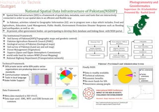
National Spatial Data Infrastructure of Pakistan(NSDIP) Presented By: Rashid Javed
 Spatial Data Infrastructure (SDI) is a framework of spatial data, metadata, users and tools that are interactively
connected in order to use spatial data in an efficient and flexible way.
 In Pakistan, activities related to Geographic Information (GI) are in progress now a days which includes, Food and
Agriculture,, Education, Land Management, Public Health, Environment Protection Disaster Response such as flooding
and earthquakes, as well as etc .
 At present, other government bodies are participating to develop their database and linking those with NSDI portal.
http://pakistanwetlands.org/reports/2_Database.pdf
www.gsdi.orggsdiconfgsdi12papers8.pdf
The Institutional Framework:
 Soil Survey of Pakistan(SOP)(Topographic maps and geodetic control)
 Pakistan Agriculture Research Council (PARC)
 Geological survey of Pakistan (Geological maps)
 Soil survey of Pakistan (Land use and soil map)
 Forest Management (Vegetation)
 Suparco (Space and Upper Atmospheric Commission)
 world wide fund for nature WWF (Forest Mapping)
 National Highway Department (Transportation network)
Technical Framework:
 56% private sector while 60% public sector
organizations are producing data on various
standards.
 Communication network.
 Tools in local language
Stake holder Support
Data Framework :
Meta data standard is ISO 19115.
Data type used : XML, WFS and ESRI formats are
common.
Finally NSDI:
Data is readily available.
Technical solutions.
Economic benefits.
No more funds for SDI.
Awareness among people.
Supervisor: Dr. H.Lehmkühler

More Related Content

Viewers also liked

Non susceptibility slideshare
Non susceptibility slideshareNon susceptibility slideshare
Non susceptibility slideshare
Ivan Marchesini
 
landslide risk assessment_Lanni_Pretto
landslide risk assessment_Lanni_Prettolandslide risk assessment_Lanni_Pretto
landslide risk assessment_Lanni_Pretto
guestca23f5
 
Nepal & bhutan landslide risk assessment rural sector guidelines for best pra...
Nepal & bhutan landslide risk assessment rural sector guidelines for best pra...Nepal & bhutan landslide risk assessment rural sector guidelines for best pra...
Nepal & bhutan landslide risk assessment rural sector guidelines for best pra...
Bhim Upadhyaya
 
Urban Flood Risk Reduction by Resiliency Planning
Urban Flood Risk Reduction by Resiliency PlanningUrban Flood Risk Reduction by Resiliency Planning
Urban Flood Risk Reduction by Resiliency Planning
REMYA PANICKER
 
Integrated risk assessment tools for decision-making. A case study from lands...
Integrated risk assessment tools for decision-making. A case study from lands...Integrated risk assessment tools for decision-making. A case study from lands...
Integrated risk assessment tools for decision-making. A case study from lands...
Global Risk Forum GRFDavos
 
Clim-final
Clim-finalClim-final
Clim-final
Ako Heidari
 
Landslide_Mapping_Sri lanka
Landslide_Mapping_Sri lankaLandslide_Mapping_Sri lanka
Landslide_Mapping_Sri lanka
RASHID JAVED
 
Schneider - Impact of Largelandslide
Schneider - Impact of LargelandslideSchneider - Impact of Largelandslide
Schneider - Impact of Largelandslide
ceriuniroma
 
Precipitation and rain gauges
Precipitation and rain gaugesPrecipitation and rain gauges
Precipitation and rain gauges
Nikhil Holsamudrkar
 
Measurement of precipitation (rainfall )
Measurement of precipitation (rainfall )Measurement of precipitation (rainfall )
Measurement of precipitation (rainfall )
SULAKSHYA GAUR
 
Lecture 4: Statistical Inference
Lecture 4: Statistical InferenceLecture 4: Statistical Inference
Lecture 4: Statistical Inference
Marina Santini
 
Hydrology measuring rain
Hydrology measuring rainHydrology measuring rain
Hydrology measuring rain
Sajjad Ahmad
 
Measurement of precipitation
Measurement of precipitationMeasurement of precipitation
Measurement of precipitation
animesh91
 
Rain gauge
Rain gauge   Rain gauge
Rain gauge
chintanmehta007
 
Methods of measuring rainfall
Methods of measuring rainfallMethods of measuring rainfall
Methods of measuring rainfall
hlksd
 
Rainfall measurement methods
Rainfall measurement methodsRainfall measurement methods
Rainfall measurement methods
Pranamesh Chakraborty
 
Precipitation
Precipitation Precipitation
Precipitation
Atif Satti
 
Precipitation and its estimation
Precipitation and its estimationPrecipitation and its estimation
Precipitation and its estimation
Mohsin Siddique
 
Precipitation presentation
Precipitation presentationPrecipitation presentation
Precipitation presentation
Hamza Ali
 
Rain guage
Rain guageRain guage
Rain guage
vigyanashram
 

Viewers also liked (20)

Non susceptibility slideshare
Non susceptibility slideshareNon susceptibility slideshare
Non susceptibility slideshare
 
landslide risk assessment_Lanni_Pretto
landslide risk assessment_Lanni_Prettolandslide risk assessment_Lanni_Pretto
landslide risk assessment_Lanni_Pretto
 
Nepal & bhutan landslide risk assessment rural sector guidelines for best pra...
Nepal & bhutan landslide risk assessment rural sector guidelines for best pra...Nepal & bhutan landslide risk assessment rural sector guidelines for best pra...
Nepal & bhutan landslide risk assessment rural sector guidelines for best pra...
 
Urban Flood Risk Reduction by Resiliency Planning
Urban Flood Risk Reduction by Resiliency PlanningUrban Flood Risk Reduction by Resiliency Planning
Urban Flood Risk Reduction by Resiliency Planning
 
Integrated risk assessment tools for decision-making. A case study from lands...
Integrated risk assessment tools for decision-making. A case study from lands...Integrated risk assessment tools for decision-making. A case study from lands...
Integrated risk assessment tools for decision-making. A case study from lands...
 
Clim-final
Clim-finalClim-final
Clim-final
 
Landslide_Mapping_Sri lanka
Landslide_Mapping_Sri lankaLandslide_Mapping_Sri lanka
Landslide_Mapping_Sri lanka
 
Schneider - Impact of Largelandslide
Schneider - Impact of LargelandslideSchneider - Impact of Largelandslide
Schneider - Impact of Largelandslide
 
Precipitation and rain gauges
Precipitation and rain gaugesPrecipitation and rain gauges
Precipitation and rain gauges
 
Measurement of precipitation (rainfall )
Measurement of precipitation (rainfall )Measurement of precipitation (rainfall )
Measurement of precipitation (rainfall )
 
Lecture 4: Statistical Inference
Lecture 4: Statistical InferenceLecture 4: Statistical Inference
Lecture 4: Statistical Inference
 
Hydrology measuring rain
Hydrology measuring rainHydrology measuring rain
Hydrology measuring rain
 
Measurement of precipitation
Measurement of precipitationMeasurement of precipitation
Measurement of precipitation
 
Rain gauge
Rain gauge   Rain gauge
Rain gauge
 
Methods of measuring rainfall
Methods of measuring rainfallMethods of measuring rainfall
Methods of measuring rainfall
 
Rainfall measurement methods
Rainfall measurement methodsRainfall measurement methods
Rainfall measurement methods
 
Precipitation
Precipitation Precipitation
Precipitation
 
Precipitation and its estimation
Precipitation and its estimationPrecipitation and its estimation
Precipitation and its estimation
 
Precipitation presentation
Precipitation presentationPrecipitation presentation
Precipitation presentation
 
Rain guage
Rain guageRain guage
Rain guage
 

Similar to NSDI PAKISTAN

SDIAPv5n11
SDIAPv5n11SDIAPv5n11
SDIAPv5n11
tutorialsruby
 
Global Soil Information Facilities - current status - by H. I. Reuter
Global Soil Information Facilities - current status - by H. I. ReuterGlobal Soil Information Facilities - current status - by H. I. Reuter
Global Soil Information Facilities - current status - by H. I. Reuter
FAO
 
50120140507014
5012014050701450120140507014
50120140507014
IAEME Publication
 
Desertification and Land Degradation Atlas of India (Based on IRS AWiFS data ...
Desertification and Land Degradation Atlas of India (Based on IRS AWiFS data ...Desertification and Land Degradation Atlas of India (Based on IRS AWiFS data ...
Desertification and Land Degradation Atlas of India (Based on IRS AWiFS data ...
ConsunEnergy
 
FINAL REPORT
FINAL REPORTFINAL REPORT
FINAL REPORT
Charu Kamra
 
role of Geospatial technology in agriculture
role of Geospatial technology  in agriculturerole of Geospatial technology  in agriculture
role of Geospatial technology in agriculture
Dr. MADHO SINGH
 
Open Based Systems Eng 010706 Titech
Open Based Systems Eng 010706 TitechOpen Based Systems Eng 010706 Titech
Open Based Systems Eng 010706 Titech
Farhan Helmy
 
Status and Perspectives of GIS Application in BANGLADESH
Status and Perspectives of GIS Application in BANGLADESHStatus and Perspectives of GIS Application in BANGLADESH
Status and Perspectives of GIS Application in BANGLADESH
Bayes Ahmed
 
Geographical information system
Geographical information systemGeographical information system
Geographical information system
Rabail Urooj
 
Scope of gis in pakistan
Scope of gis in pakistan Scope of gis in pakistan
Scope of gis in pakistan
Sohail Akbar Goheer
 
Surveyor for the Nation
Surveyor for the NationSurveyor for the Nation
Surveyor for the Nation
Hasanuddin Z. Abidin
 
Wetland and Water Bodies Atlas of Jammu and kashmir
Wetland and Water Bodies Atlas of Jammu and kashmirWetland and Water Bodies Atlas of Jammu and kashmir
Wetland and Water Bodies Atlas of Jammu and kashmir
Shakil Romshoo
 
Building spatial database for cuttack municipal corporation a geospatial tech...
Building spatial database for cuttack municipal corporation a geospatial tech...Building spatial database for cuttack municipal corporation a geospatial tech...
Building spatial database for cuttack municipal corporation a geospatial tech...
eSAT Journals
 
Prof. Dr. Ir. Hasanuddin Z. Abidin - Ka BIG SLF 2018.pdf
Prof. Dr. Ir. Hasanuddin Z. Abidin - Ka BIG SLF 2018.pdfProf. Dr. Ir. Hasanuddin Z. Abidin - Ka BIG SLF 2018.pdf
Prof. Dr. Ir. Hasanuddin Z. Abidin - Ka BIG SLF 2018.pdf
jancukbavarian
 
Evaluation of Groundwater Resource Potential using GIS and Remote Sensing App...
Evaluation of Groundwater Resource Potential using GIS and Remote Sensing App...Evaluation of Groundwater Resource Potential using GIS and Remote Sensing App...
Evaluation of Groundwater Resource Potential using GIS and Remote Sensing App...
IJERA Editor
 
Evaluation of Groundwater Resource Potential using GIS and Remote Sensing App...
Evaluation of Groundwater Resource Potential using GIS and Remote Sensing App...Evaluation of Groundwater Resource Potential using GIS and Remote Sensing App...
Evaluation of Groundwater Resource Potential using GIS and Remote Sensing App...
IJERA Editor
 
Abbottabad State of Environment and Development Plan
Abbottabad State of Environment and Development PlanAbbottabad State of Environment and Development Plan
Abbottabad State of Environment and Development Plan
zubeditufail
 
International Journal of Engineering Research and Development
International Journal of Engineering Research and DevelopmentInternational Journal of Engineering Research and Development
International Journal of Engineering Research and Development
IJERD Editor
 
Implementation Concepts of Sudan Integrated Geospatial Information Frame
Implementation Concepts of Sudan Integrated Geospatial Information FrameImplementation Concepts of Sudan Integrated Geospatial Information Frame
Implementation Concepts of Sudan Integrated Geospatial Information Frame
ijtsrd
 

Similar to NSDI PAKISTAN (20)

SDIAPv5n11
SDIAPv5n11SDIAPv5n11
SDIAPv5n11
 
SDIAPv5n11
SDIAPv5n11SDIAPv5n11
SDIAPv5n11
 
Global Soil Information Facilities - current status - by H. I. Reuter
Global Soil Information Facilities - current status - by H. I. ReuterGlobal Soil Information Facilities - current status - by H. I. Reuter
Global Soil Information Facilities - current status - by H. I. Reuter
 
50120140507014
5012014050701450120140507014
50120140507014
 
Desertification and Land Degradation Atlas of India (Based on IRS AWiFS data ...
Desertification and Land Degradation Atlas of India (Based on IRS AWiFS data ...Desertification and Land Degradation Atlas of India (Based on IRS AWiFS data ...
Desertification and Land Degradation Atlas of India (Based on IRS AWiFS data ...
 
FINAL REPORT
FINAL REPORTFINAL REPORT
FINAL REPORT
 
role of Geospatial technology in agriculture
role of Geospatial technology  in agriculturerole of Geospatial technology  in agriculture
role of Geospatial technology in agriculture
 
Open Based Systems Eng 010706 Titech
Open Based Systems Eng 010706 TitechOpen Based Systems Eng 010706 Titech
Open Based Systems Eng 010706 Titech
 
Status and Perspectives of GIS Application in BANGLADESH
Status and Perspectives of GIS Application in BANGLADESHStatus and Perspectives of GIS Application in BANGLADESH
Status and Perspectives of GIS Application in BANGLADESH
 
Geographical information system
Geographical information systemGeographical information system
Geographical information system
 
Scope of gis in pakistan
Scope of gis in pakistan Scope of gis in pakistan
Scope of gis in pakistan
 
Surveyor for the Nation
Surveyor for the NationSurveyor for the Nation
Surveyor for the Nation
 
Wetland and Water Bodies Atlas of Jammu and kashmir
Wetland and Water Bodies Atlas of Jammu and kashmirWetland and Water Bodies Atlas of Jammu and kashmir
Wetland and Water Bodies Atlas of Jammu and kashmir
 
Building spatial database for cuttack municipal corporation a geospatial tech...
Building spatial database for cuttack municipal corporation a geospatial tech...Building spatial database for cuttack municipal corporation a geospatial tech...
Building spatial database for cuttack municipal corporation a geospatial tech...
 
Prof. Dr. Ir. Hasanuddin Z. Abidin - Ka BIG SLF 2018.pdf
Prof. Dr. Ir. Hasanuddin Z. Abidin - Ka BIG SLF 2018.pdfProf. Dr. Ir. Hasanuddin Z. Abidin - Ka BIG SLF 2018.pdf
Prof. Dr. Ir. Hasanuddin Z. Abidin - Ka BIG SLF 2018.pdf
 
Evaluation of Groundwater Resource Potential using GIS and Remote Sensing App...
Evaluation of Groundwater Resource Potential using GIS and Remote Sensing App...Evaluation of Groundwater Resource Potential using GIS and Remote Sensing App...
Evaluation of Groundwater Resource Potential using GIS and Remote Sensing App...
 
Evaluation of Groundwater Resource Potential using GIS and Remote Sensing App...
Evaluation of Groundwater Resource Potential using GIS and Remote Sensing App...Evaluation of Groundwater Resource Potential using GIS and Remote Sensing App...
Evaluation of Groundwater Resource Potential using GIS and Remote Sensing App...
 
Abbottabad State of Environment and Development Plan
Abbottabad State of Environment and Development PlanAbbottabad State of Environment and Development Plan
Abbottabad State of Environment and Development Plan
 
International Journal of Engineering Research and Development
International Journal of Engineering Research and DevelopmentInternational Journal of Engineering Research and Development
International Journal of Engineering Research and Development
 
Implementation Concepts of Sudan Integrated Geospatial Information Frame
Implementation Concepts of Sudan Integrated Geospatial Information FrameImplementation Concepts of Sudan Integrated Geospatial Information Frame
Implementation Concepts of Sudan Integrated Geospatial Information Frame
 

NSDI PAKISTAN

  • 1. Photogrammetry and Geoinformatics National Spatial Data Infrastructure of Pakistan(NSDIP) Presented By: Rashid Javed  Spatial Data Infrastructure (SDI) is a framework of spatial data, metadata, users and tools that are interactively connected in order to use spatial data in an efficient and flexible way.  In Pakistan, activities related to Geographic Information (GI) are in progress now a days which includes, Food and Agriculture,, Education, Land Management, Public Health, Environment Protection Disaster Response such as flooding and earthquakes, as well as etc .  At present, other government bodies are participating to develop their database and linking those with NSDI portal. http://pakistanwetlands.org/reports/2_Database.pdf www.gsdi.orggsdiconfgsdi12papers8.pdf The Institutional Framework:  Soil Survey of Pakistan(SOP)(Topographic maps and geodetic control)  Pakistan Agriculture Research Council (PARC)  Geological survey of Pakistan (Geological maps)  Soil survey of Pakistan (Land use and soil map)  Forest Management (Vegetation)  Suparco (Space and Upper Atmospheric Commission)  world wide fund for nature WWF (Forest Mapping)  National Highway Department (Transportation network) Technical Framework:  56% private sector while 60% public sector organizations are producing data on various standards.  Communication network.  Tools in local language Stake holder Support Data Framework : Meta data standard is ISO 19115. Data type used : XML, WFS and ESRI formats are common. Finally NSDI: Data is readily available. Technical solutions. Economic benefits. No more funds for SDI. Awareness among people. Supervisor: Dr. H.Lehmkühler