A Spatial Data Infrastructure (SDI) is a framework of policies, institutional arrangements, technologies, data, and people that enables the effective sharing and use of geographic information, promoting interoperability and accessibility.
What is anSDI?
• “The SDI provides a basis for spatial data discovery, evaluation, and application for
users and providers within all levels of government, the commercial sector, the non-
profit sector, academia and by citizens in general.” The SDI Cookbook, http://www.gsdi.org,
• A spatial data infrastructure (SDI) is a data infrastructure implementing a framework
of geographic data, metadata, users and tools that are interactively connected in
order to use spatial data in an efficient and flexible way (Wikipedia)
• SDIs are defined as the technology, policies, standards, human resources, and related
activities necessary to acquire, process, distribute, use, maintain, and preserve spatial
data (Masser, 2005)
• National Spatial Data Infrastructure (NSDI) means the technology, policies, standards,
and human resources necessary to acquire, process, store, distribute, and improve
utilization of geospatial data (Executive Order 12906, 1994)
SDI
3.
What is anSDI?
SDI
Like a road infrastructure
makes it possible to connect
different sites,
a spatial data infrastructure
makes it possible to connect
data located at different
sources
Data easily
discoverable
and accessible
to users
Facilitating
development
of new
applications
and services
SDI Hierarchy
SDI
SDIs areseen in many countries across the world as way to:
• Increase efficiency of
public administration by
sharing information and
processes
• Contribute to open
Public Sector
Information increasing
transparency in decision
making, and new
services, innovation,
and jobs
7.
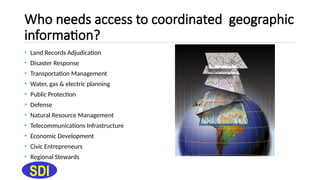
Who needs accessto coordinated geographic
information?
SDI
• Land Records Adjudication
• Disaster Response
• Transportation Management
• Water, gas & electric planning
• Public Protection
• Defense
• Natural Resource Management
• Telecommunications Infrastructure
• Economic Development
• Civic Entrepreneurs
• Regional Stewards
8.
Components of aSpatial Data Infrastructure
(SDI)
SDI
• Policies & Institutional Arrangements (governance, data privacy &
security, data sharing, cost recovery)
• People (training, professional development, cooperation, outreach)
• Data (digital base map, thematic, statistical, place names)
• Technology (hardware, software, networks, databases, technical
implementation plans)
9.
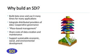
Why build anSDI?
SDI
• Build data once and use it many
times for many applications
• Integrate distributed providers of
data: Cooperative governance
• “Place-based management”
• Share costs of data creation and
maintenance
• Support sustainable economic,
social, and environmental
development
10.
The outcomes ofan NSDI
• The participant members (contributors and users) are known and can
interact
• Core and specialized map and data services are easily discoverable
and accessible
• Decision-makers and analysts have ready access to the right geo-
information for input to analytical and visual models – indicators,
models, trends, patterns
SDI
11.
Benefits of anNSDI
• Development of a private sector involved with data sales and added
value
• A chance for communities of all sizes and capabilities to participate in
the knowledge economy
• A more informed voter/citizen
• Increased access to distributed geo-information through standards
SDI
12.
Creating the motivation
•Development of an SDI should be a voluntary and have long-term
vision
• Government roles may require both incentives and directives
• Commercial and non-commercial participants should find SDI
appealing as a market
• The correct solution for NSDI must be defined by the community
SDI
13.
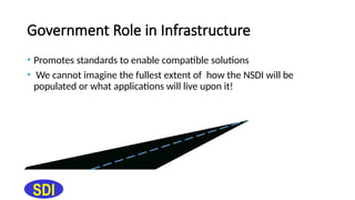
Government Role inInfrastructure
• Promotes standards to enable compatible solutions
• We cannot imagine the fullest extent of how the NSDI will be
populated or what applications will live upon it!
SDI
14.
overview of thepieces of the NSDI
SDI
The first task is to inventory who has what data of what type
and quality
A standardized form of metadata was published in June 1994
by the FGDC. An international standard now exists and will be
adopted by the US beginning in 2005
Metadata
15.
Metadata...
• Provides documentationof existing internal geospatial data resources
within an organisation (inventory)
• Permits structured search and comparison of held spatial data by
others (catalog)
• Provides end-users with adequate information to take the data and
use it in an appropriate context (documentation)
SDI
16.
Metadata Formats
• TheFGDC Content Standard for Digital Geospatial Metadata (CSDGM,
1998) is expressed in XML for exchange and text and HTML for
presentation
• Participants in the Geospatial Data Clearinghouse offer other
metadata formats, including Dublin Core, ANZLIC, and expressions of
ISO 19115
• Any metadata format can be presented by requesting the HTML
format
SDI
17.
Metadata...
Metadata describes existingdata holdings for order, retrieval, or
local use
Metadata should be used to describe all types of data,
emphasis on ‘truth in labeling’
SDI
Metadata
Geospatial Data
18.
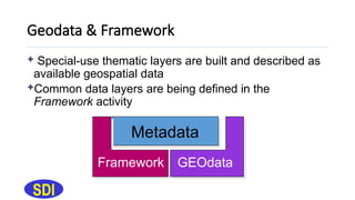
Geodata & Framework
SDI
Special-use thematic layers are built and described as
available geospatial data
Common data layers are being defined in the
Framework activity
Metadata
Framework GEOdata
19.
Framework supports...
• Communitydevelopment of sets of spatial features, feature
representation, and attribution to a lowest common denominator
• Participant collecting, converting, or associating information to
common Framework data standards with an encoding format to
facilitate exchange
• Multiple representations of real-world features at different scales and
times by feature identifier and generalization
SDI
20.
Framework Data Standards
Eachthematic content standard has an informative annex describing its
implementation as XML/GML Application Schemas using OGC Web
Feature Services
SDI
21.
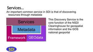
Services
The NSDI includesthe services to help discover and interact with
data
SDI
Services
Metadata
Framework GEOdata
22.
Services…
An important commonservice in SDI is that of discovering
resources through metadata
SDI
Services
Metadata
Framework GEOdata
This Discovery Service is the
core function of the NSDI
Clearinghouse for geospatial
information and the GOS
national geoportal
23.
NSDI Clearinghouse Networkand geodata.gov
portal (Discovery)
• Supports uniform, distributed search through a single user interface
to all domestic metadata collections to find data and maps
• A free advertising mechanism to provide world access to your
holdings under the principle of “truth-in-labeling”
• Search for spatial data through fields and full-text in the metadata and
categorical browsing
• Links through to full data access and online web mapping services,
where available
SDI
24.
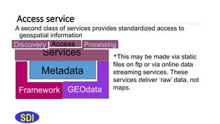
Access service
A secondclass of services provides standardized access to
geospatial information
SDI
Services
Metadata
Framework GEOdata
This may be made via static
files on ftp or via online data
streaming services. These
services deliver ‘raw’ data, not
maps.
Access Processing
Discovery
25.
Data Access concepts
SDI
•Standardisation of data access implies several things:
• Definition of model used for the data to be exchanged
• Adoption of an exchange or encoding format
• Agreement on data access protocol(s)
• Organisations should strive to identify the mode(s) of operation to
simplify data exchange
26.
Data Access Examples
•Administrative boundary data conforming to the GlobalMap data
model, packaged as Vector Product Format (VPF), made accessible
over ftp
• Panchromatic 10m, single-band, rectified imagery to a specific
coordinate reference system, packaged as GEOTIFF with LZW
compression, made accessible on CD-ROM
SDI
Processing Services
Theseinclude capabilities that extend and enhance the delivery of
data through processes applied to raw data:
Web Mapping Services (OGC WMS)
Symbolization (OGC SLD)
Coordinate Transformation (OGC WCTS)
Analysis or topologic overlay services
Routing services
SDI
29.
Geospatial Interoperability ReferenceModel
(GIRM)
• Voluntary technical participation in the NSDI is defined through the
GIRM
• The GIRM includes data standards, formats, protocols, and interface
specifications to maximize interoperability
• http://gai.fgdc.gov/girm/
SDI
30.
Standards
SDI
Standardization makesSDI work
Standards touch every SDI activity
Standards include
specifications, formal
standards, and
documented
practices
31.
FGDC Standards...
• Createdby FGDC working groups and thematic subcommittees as
national standards, representing community consensus view of data
theme or common approach
• Submitted for 90-day public review
• Reviewed across disciplines for uniformity
• Published as US Federal Standards
• Standards by ISO, OGC, W3C and other standardization bodies are
used FIRST, if they exist!
• http://www.fgdc.gov/standards/standards.html
SDI
How does OneStopGeoportal support NSDI?
• GOS has a timeline for implementation of NSDI components by all
partners
• Deploys a “one-stop” portal (National eoportal) for quick access to
community data, services, and related resources
• Standards are being developed with multi-sectoral stakeholders as
national (ANSI) standards, not FGDC ones
• Goals include measures of costs and savings through cost-sharing in
data acquisition, processing, and service of geospatial data
SDI