Download as PDF, PPTX


![Scan-to-BIM
Input PCD Sampling Filtering
Spatial
indexing
Segmentation
Scan To
Geometry
Geometry To BIM
load S-G
rules
Geometry
mapping
load G-B
rules
BIM mapping
BIM
Validation
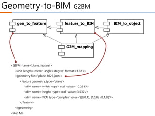
<?xml version="1.0" encoding="utf-8"?>
<RE3D_objects>
<object type="KS_SP_100_T50" name="KS standard straight pipe 100mm thick 50mm. copper
material">
<parameters>
radius=100, thickness=50, axis_point1=(0,0,0), axis_point2=(10,0,0)
</parameters>
</object>
<object type="KS_LBP_100_T50" name="KS L-bow pipe 100mm thick 50mm. copper material">
<parameters>
radius=100, thickness=50, axis_point1=(0,0,0), axis_intersection=(10,10,0),
axis_point2=(10,0,0), axis_intersection_angle=90.0
</parameters>
</object>
</RE3D_objects>
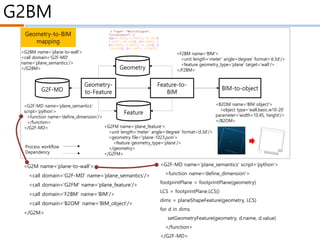
<?xml version="1.0" encoding="utf-8"?>
<RE3D_shapes>
<shape id="shape.1" type="straight_cylinder">
<parameters>R=1.1, axis_point1=(0,0,0), axis_point2=(10,0,0)</parameters>
</shape>
<shape id="shape.2" type="plane">
<parameters>A=0.5, B=0.2, C=0.3, D=1.0</parameters>
<boundary>(0,0),(20,0),(20,20),(0,20)</boundary>
</shape>
</RE3D_shapes>
Database
#name: string
namespce RE3D
{
};
PointCloud
#name: string
#path: string
+load()
PCL:Point<XYZ>
SegmentationC
Segment
#name: string
#path: string
Command
+name: string
<<virtual>>+event(e: Event*)
Framework *
AddPointCloudCommand
LoadPointCloudCommand
CommandTable
+add(pCommand)
+del(name)
+execute(name, parameters: string)
Ev
+Type{call
Paramte
Parameter
+name: string
+value: string
+type: string
*
*
*
*
Project
+name: string
PCL:PointCloud<XYZ>
PCL:Point<RGB>PCL:PointCloud<RGB>
PCL:PointCloud<Normal> PCL:Point<Normal>
*
*
PCL:PointIndices
#indices
Shape
#<<Unique>> name: string
ShapeList
#name: string
+load()
*
FilteringCommand
ExtractStraightPipeCommand
CylinderShape
#radius: double
LBowCylinderShape
PlaneShape
StrightCylinderShape
ObjectMappingRule
QualityCheckRule
NewProjectCommand
Application
<<singleton>>
SegmentationByNo
SegmentationByPla
Object
+id: string
ObjectTable
<<singleton>>
*
LoadPointCloudCommand(e
{
id = event->GetAt("id");
Object* pObject = Objec
Project* pProject = dyna
pPointCloud = new PointC
pProject->GetDatabase()
}
Rule
-name: string
-path: string
+Rule(name: string)
<<virtual>>+parsing(path: string)
<<virtual>>+execute()
RuleSet
<<enumeration>>
#qualityCheckRules
#objectMappingRules*
SCAN 형상 편차
scan2lod -interval=[number m] input.pcd ouput.pcd
scan2filter -option=[remove_noise] -param=[", , , "]
input*.pcd output
scan2grid -interval=[number m] input.pcd ouput
scan2seg -type=[plane] input.pcd output
seg2geo -gm=[mesh | plane] -debug=[segment_pcd
| log | progress] -out=[pcd | json] input.pcd ouput
merge_geo -in=[json] input output
Input PCD Sampling Filtering
Spatial
indexing
Segmentation
Scan To
Geometry
Geometry To BIM
load S-G
rules
Geometry
mapping
load G-B
rules
BIM mapping
BIM
Validation
<?xml version="1.0" encoding="utf-8"?>
<RE3D_objects>
<object type="KS_SP_100_T50" name="KS standard straight pipe 100mm thick 50mm. copper
material">
<parameters>
radius=100, thickness=50, axis_point1=(0,0,0), axis_point2=(10,0,0)
</parameters>
</object>
<object type="KS_LBP_100_T50" name="KS L-bow pipe 100mm thick 50mm. copper material">
<parameters>
radius=100, thickness=50, axis_point1=(0,0,0), axis_intersection=(10,10,0),
axis_point2=(10,0,0), axis_intersection_angle=90.0
</parameters>
</object>
</RE3D_objects>
<?xml version="1.0" encoding="utf-8"?>
<RE3D_shapes>
<shape id="shape.1" type="straight_cylinder">
<parameters>R=1.1, axis_point1=(0,0,0), axis_point2=(10,0,0)</parameters>
</shape>
<shape id="shape.2" type="plane">
<parameters>A=0.5, B=0.2, C=0.3, D=1.0</parameters>
<boundary>(0,0),(20,0),(20,20),(0,20)</boundary>
</shape>
</RE3D_shapes>
Database
#name: string
namespce RE3D
{
};
PointCloud
#name: string
#path: string
+load()
PCL:Point<XYZ>
SegmentationCo
Segment
#name: string
#path: string
Command
+name: string
<<virtual>>+event(e: Event*)
Framework *
AddPointCloudCommand
LoadPointCloudCommand
CommandTable
+add(pCommand)
+del(name)
+execute(name, parameters: string)
Ev
+Type{call,
Paramter
Parameter
+name: string
+value: string
+type: string
*
*
*
*
Project
+name: string
PCL:PointCloud<XYZ>
PCL:Point<RGB>PCL:PointCloud<RGB>
PCL:PointCloud<Normal> PCL:Point<Normal>
*
*
PCL:PointIndices
#indices
Shape
#<<Unique>> name: string
ShapeList
#name: string
+load()
*
FilteringCommand
ExtractStraightPipeCommand
CylinderShape
#radius: double
LBowCylinderShape
PlaneShape
StrightCylinderShape
ObjectMappingRule
QualityCheckRule
NewProjectCommand
PApplication
<<singleton>>
SegmentationByNor
SegmentationByPlan
Object
+id: string
ObjectTable
<<singleton>>
*
LoadPointCloudCommand(ev
{
id = event->GetAt("id");
Object* pObject = Object
Project* pProject = dynam
pPointCloud = new PointC
pProject->GetDatabase()
}
Rule
-name: string
-path: string
+Rule(name: string)
<<virtual>>+parsing(path: string)
<<virtual>>+execute()
RuleSet
<<enumeration>>
#qualityCheckRules
#objectMappingRules*
SCAN 형상 편차
scan2lod -interval=[number m] input.pcd ouput.pcd
scan2filter -option=[remove_noise] -param=[", , , "]
input*.pcd output
scan2grid -interval=[number m] input.pcd ouput
scan2seg -type=[plane] input.pcd output
seg2geo -gm=[mesh | plane] -debug=[segment_pcd
| log | progress] -out=[pcd | json] input.pcd ouput
merge_geo -in=[json] input output](https://image.slidesharecdn.com/sbf-200704063133/85/SBF-Scan-BIM-Field-10-320.jpg)
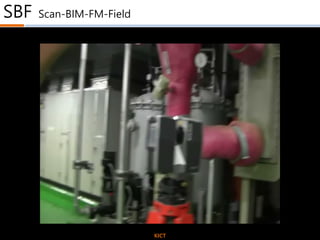
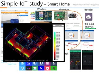
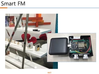
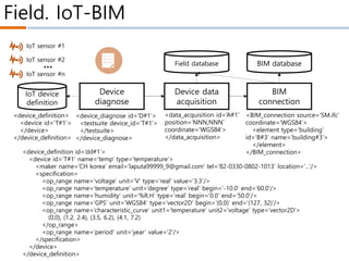
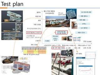
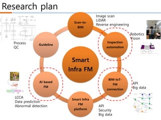
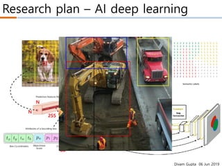

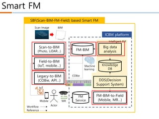
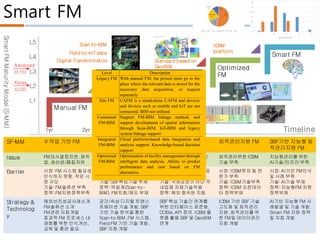
This document discusses a SBF (Scan-BIM-Field) technology for effective facility management of infrastructure. SBF integrates 3D scanning, building information modeling (BIM), and field data from sensors to create a digital twin for infrastructure facilities. The document presents a maturity model for facility management with five levels from manual to smart/intelligent FM. It analyzes barriers and strategies to advance SBF technology, including developing standards, technologies for digital transformation and linking scan data, BIM, and Internet of Things field data.


