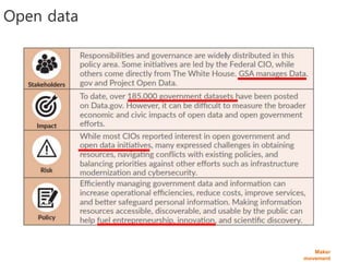
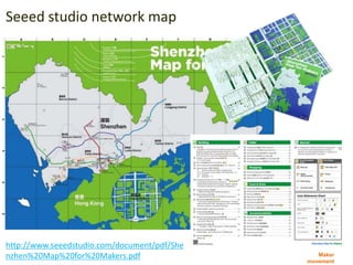
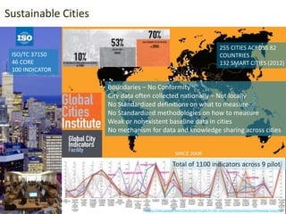
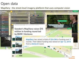
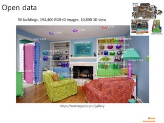
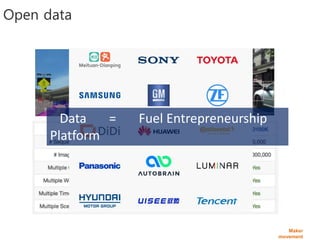
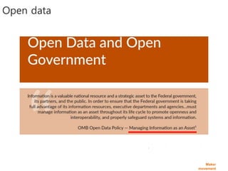
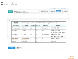
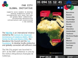
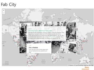
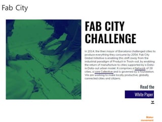
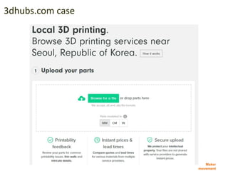
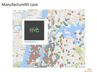
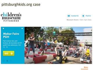
인공지능 기반 미디어아트 최신 기술, 동향 및 사례를 공유합니다. 특히, 딥러닝을 이용한 예술과 관련된 기술을 확인하고, 관련 작품들을 살펴보겠습니다. 이 세미나는 한전아트센터에서 진행하는 2019년 오픈 미디어아트 전시 세미나(2월 10일 오후 2시)의 하나로 기획되었습니다.
전시 링크 - https://vmspace.com/news/news_view.html?base_seq=NDM5
This document discusses construction startups and open source technology. It covers topics like Industry 4.0 with open source, open source movements, open source service markets, open source licenses, autonomous vehicles, deep learning, IoT, drones, 3D printing, cloud platforms, smart cities, BIM, VR/AR, robotics, blockchains, open data, and construction startups using open source technologies. The document provides references on these topics as well.
이 글은 블록체인과 건설 분야 유스케이스에 대해 간략히 요약한 자료입니다. 기존 4차 산업혁명과 건설의 관계에 대한 발표 내용을 바탕으로 블록체인 부분만 요약하였습니다.
블록체인 개념, 주요 구성요소, 암호화, 해쉬, 건설 분야 적용 사례 등을 언급하고 있습니다. 스마트시티, BIM, COBie, IoT 등 서비스 토큰, 스마트 건설 계약 및 컨텐츠 형상 무결성 보장 등에 적용 시도되고 있는 상황입니다. 다만, 아직 정책적 기술적인 안전성은 아직 이슈가 있습니다.
이 슬라이드는 4차산업혁명과 건설, 그리고 블록체인에 대한 내용입니다. 건설 관점에서 이런 기술들이 어떻게 서로 엮이고, 새로운 가치를 만들어내는 지를 확인해 봅니다. 블록체인은 스마트 계약의 기반이되며, 다양한 서비스 토큰을 통해, 스마트 건설의 부가가치를 담아 이해당사자들 사이를 전달할 것입니다.
건설 관점에서 블록체인을 이용하기 위해, 블록체인의 기본 개념부터 스마트계약, 토큰 및 ICO를 개발하는 방법을 설명합니다. 아울러, 비트코인과 같은 블록체인의 실행 메커니즘을 구체적으로 다루고 있습니다. 이 자료에 포함된 링크를 통해 좀더 상세한 내용을 확인할 수 있습니다.
This document summarizes a conference on smart future applications called "Smart Future 2015". It discusses technologies like gigabit wired and wireless networks and GENI racks for sensing, analyzing, and acting capabilities. Example applications mentioned include 4K streaming video, IoT sensors, virtual reality, and more secure and collaborative internet applications. Organizational aspects are also covered like public-private partnerships, open data policies, and sustainable business models. The document highlights several "firsts" for this conference, including the largest demonstration collection showcasing smart city IoT applications.
I gave this talk at the ITEA3 Smart City Business Event. In this talk, I introduced mago3D project, an open source based digital twin platform first. And then shared the real cases that I and my company have carried out in various industries. I concluded the talk with what I've learnt from these real projects. Some food for thoughts around digital twin were provided for further discussion.
지난 4월 3일에 대전 KAIST 증강현실연구센터 콜로키움에서 발표한 자료입니다.
‘Digital Twin’ is a digital replication of real world objects, processes, phenomena that can be used for various purposes. Digital twin concept backs to manufacturing industry in early 2000s for the PLM (Product Lifecycle Management) purposes. It is based on the idea that a digital informational construct about a physical system could be created as an entity on its own. As cities are going through digital transformation, there are many attempts to apply digital twin concept to manage urban issues. Those attempts look set to play an increasingly important role in the creation of smart cities around the world and in addressing major public health, safety and environmental issues. Bringing the virtual and real worlds together in this way can help to give better analysis, visualization, and simulation to decision-making process. This will be a multi-way process with iterative feedback among stakeholders. In this colloquium, I talked about the recent trends of Smart City from the perspective of digital twin.
2021년 2월 9일 국토연구원 디지털트윈연구센터 출범 기념 세미나에서 발표한 자료입니다. 제조업에서 출발한 디지털트윈이 도시관리, 공간정보 분야까지 그 활용을 넓히게 된 배경, 도시/국토관리에서 디지털트윈을 활용할 때 공간규모별로 고려해야 할 사항들을 사례 중심으로 발표하였습니다.
A sliideshow based on our recent white paper looking at the role that 3D technologies might play in building dynamic and information rich whole city models and their contribution to the Smart City agenda
Web-based GIS was seen as a way to improve access and transparency by making information available online for public participation. However, early web GIS projects still faced many of the same limitations as traditional GIS, such as only being accessible to computer-literate individuals. The development of new geospatial data formats and open source mapping tools has allowed non-experts to easily create and share their own geospatial data. This has led to a rise in collaborative mapping projects where geospatial data is constantly updated by citizens, governments, and businesses. The future is expected to see more location-based services and geospatial data created by amateurs, as mobile and ubiquitous computing continues to spread.
The document discusses creating the world's first open programmable city by building a research network in Bristol, UK integrating optical, wireless, IoT, and computing technologies. It will provide an experimental platform and utility called "City Experimentation as a Service". The network will support digital innovation and include an SDN-enabled optical network, wireless network, IoT sensors, and cloud infrastructure. It aims to be technology agnostic and provide network slicing to share resources among users through network virtualization. This will create an open testbed for diverse infrastructure, service, and application requirements.
Emerging Trend #2 | Artificial Intelligence, construction and operations of b...Leonard
Artificial Intelligence is questioning business models in all industries. It is opening promising new avenues for the future of the design, building and operations of buildings and mobility infrastructure. AI is also at the very heart of smart city and raises new issues in the governance of territories.
Application of BIM for Construction Scrutiny & Town Planning - Future full of AIShadaab Sayyed
This is a presentation that was presented at NICMAR ICCRIP 2018.
The concept is based on the implementation of AI to construction monitoring & planning activities. It considers using BIM models to map the DNA of a city.
Bristol aims to become the world's first open programmable city through a city-wide digital infrastructure project called Bristol Is Open. The project will create an open software defined network, Internet of Things platform, and means of collecting and analyzing big data to enable mass co-creation of smart city applications. This will allow Bristol to better manage challenges associated with major trends like rapid urbanization, new technologies, demands for sustainable cities, and empowered citizens. Bristol Is Open has received £75 million in funding and will roll out its digital network starting in late 2015, engaging a wide range of partners from academia, businesses, technology companies and communities.
Products And Platforms In The Age Of CommunitiesBenjamin Tincq
A very straighforward presentation about how all stages of product lifecyle are being platformized for greater community interaction. Presentated at Hub Day conference in Paris on June 2014.
Investment Opportunities in the New Normal - AirTree VenturesMelissa Ran
The document discusses investment opportunities that have arisen from changes brought about by the COVID-19 pandemic. It outlines five key areas: 1) A remote-first world where remote work tools have grown significantly. 2) Internet models now work for sectors like healthcare and education that have been slow to adopt technology. 3) E-commerce growth that was previously years-long has accelerated to growth over months. 4) The rise of the creator economy empowering individuals. 5) Esports growing to become the new social experience as gaming culture expands. The presentation argues these trends open opportunities for startups addressing issues in a newly digital world.
This talk was given at the FOSS4G Asia 2021 held at Kathmandu, Nepal.
Have you ever heard about Open Indoor Map project? No? Don't worry about that you don't know the OIM(Open Indoor Map) project, because OIM is quite new project and not publicly well-known. OIM project got many inspiration from Open Street Map. OIM is a project to let users upload & share their indoor related data. Users can upload their IFC, CityGML, IndoorGML, 3DS data that represent indoor space to the OIM server and OIM server service those data through web in 3D. OIM project makes use of many open source project including mago3D, Assimp, and others. I expect OIM project could expand crowd-sourced map to indoor space as well by complementing Open Street Map.
Presented at the Advanced Engineering Conference at ITEC Rotterdam, Netherlands on 17 May 2017. The human factors associated with Industry 4.0 and the increasing role of simulation in support of training both people and autonomous systems.
come la digitalizzazione dei processi e dei prodotti abilita la trasformazione del modello di business ed il passaggio dall'economia del tangibile all'economia dell'intangibile
The City of Norfolk, Virginia has successfully incorporated Geographic Information Systems (GIS) and Pictometry aerial imagery into its operations, led by GIS manager Fraser Picard. Over the past decade, Picard has trained over 700 city employees on GIS tools and expanded usage from 17 initial users to over 300 daily users across 18 city departments. Norfolk transitioned smoothly to Pictometry's cloud-based CONNECT platform in 2014 to provide easy access and upgrades for widespread usage across departments for tasks like damage assessment, impervious surface measurement, and land use review. The integrated use of GIS and Pictometry imagery has enabled improved service across Norfolk city departments and established the city as a leading example of public sector GIS implementation.
Ubiquity e Autonomy : the autonomous car and the outcome economyRoberto Siagri
Roberto Siagri, CEO of EUROTECH, discusses the company's evolution from embedded computers to edge computing over the past 30 years. Eurotech provides a scalable portfolio of edge solutions including IoT gateways, edge servers, and high-performance edge computers. Their edge computing solutions include an IoT edge framework for data acquisition and connectivity management, as well as edge management capabilities. AI and digital twins are important for progress, but must be developed and applied responsibly. Eurotech advocates for circular economy business models that focus on outcomes rather than product sales to increase efficiency and sustainability.
UI/UX for Indoor/Outdoor Seamless Navigation?SANGHEE SHIN
I gave this talk at the 110th OGC TC meeting held at National University of Singapore. I shared my experiences and thoughts on UI/UX issues for seamless navigation between indoor and outdoor space.
A Research on EIA(Environmental Impact Assessment) Data Visualization Technol...SANGHEE SHIN
This talk was given at the FOSS4G Buenos Aires 2021.
This research is about the development of an EIA(Environmental Impact Assessment) decision support system that effectively integrates and visualizes the results of the EIA review process and related information such as BIM/GIS, modeling data, and sensor data. The final goal is to improve the EIA process so that not only experts but also non-experts can participate in the EIA process and easily understand the EIA statements using innovative technologies such as 3D GIS and Easy Finger real-time simulation. The final system will be developed and opened as an open source. This research is 5 years long project funded by Ministry of Environment, South Korea. This talk will focus on the 1st year's research outcome and future plans.
The document provides guidance for communities to become Smart Gigabit Communities through developing gigabit applications and infrastructure. It outlines key activities including forming a steering committee, hiring a technical lead, developing and funding applications, hosting community events, and sharing applications and best practices with other communities. The goal is to foster economic growth and improve quality of life through taking advantage of high-speed connectivity.
Beyond Apps Contests The Present And Future Possibilities Of Civic Innovatio...E惠社
Vivek Kundra, former DC CTO, launched contests through the Open Data Catalog to encourage citizens to build apps using public data. This resulted in 47 apps valued at over $2.3 million being created at a cost of only $50,000, a return of over 4000%. The document discusses expanding this approach into a civic innovation marketplace and network to continue solving local problems through open data and citizen talent.
This document discusses how open data can fuel innovation both internally and externally for organizations like the US Census Bureau. It provides examples of how the Census Bureau's open data and APIs are being used by developers and communities to create applications and solutions. The document advocates for treating open government data as a product that can drive public sector innovation through platforms and ecosystems that bring together data producers and consumers.
Smarter Cities briefing for the Technology Strategy Board's Future Cities Cat...Rick Robinson
I recently spent the afternoon briefing the UK Technology Strategy Board's Future Cities Catapult team on IBM's engagement in the Smarter Cities market. This presentation covers our Research projects and "Smarter Cities Challenge" through which we developed our understanding of urban challenges and the opportunities for technology to address them; through to our engagement with entrepreneurs and other innovative ecosystems; through to case studies from our work with customers. The downloadable powerpoint file has speaker notes and links to further material.
Fing was created in 2000 by entrepreneurs and experts to promote innovation in digital services and uses. It is a network, think tank, and resource for innovators working at the intersection of technology, business, arts, and social change. Fing aims to play a pivotal role in emerging ideas and projects, mobilize stakeholders around future technology, and facilitate collaboration between users, researchers, and entrepreneurs. It achieves this through programs that bring together diverse stakeholders to share ideas and stimulate innovative action. Fing also networks internationally with startups, researchers, and institutions to accelerate innovative projects and open innovation. Additionally, Fing reports on emerging ideas, technologies, and trends.
Fing was created in 2000 by entrepreneurs and experts to detect, foster, and promote digital innovation in services and uses. Working at the crossroads of technology, business, arts, and social change, Fing is a network, think tank, and resource for innovators. Fing has over 160 members and partners and a staff of 20 that work on programs around future challenges through think tanks, open innovation, and intelligence/foresight.
ESOMAR: Rulemaking or Playmaking? Implications of the emerging co-creation l...Felix Koch
This presentation proposes a working definition of online co-creation and provides a framework to map the emerging landscape of the discipline itself. Two distinct types of online co-creation are established based on the degree of ‘participant empowerment’ they facilitate.
Two case studies then highlight the direct implications for practitioners when implementing either of the two types.
The paper is based on the experience of having set-up & curated more than 25 online co-creation communities in the past three years.
The document discusses four emerging trends:
1. The nature of success is changing as individuals have greater reach and influence due to the internet.
2. The digital world is expanding through the internet of things (IoT) and connectivity of everyday objects.
3. Power structures are shifting as IoT allows seamless data sharing across networks in a way that decentralizes control.
4. Business models must change and become more transparent as IoT enables real-time data sharing between companies and customers.
The document also summarizes efforts to involve citizens in co-creating IoT solutions through workshops in various cities to help design use cases that meet user needs and address issues of privacy, security and ethics.
Slides from US Ignite Smart Gigabit Community lighting rounds. Part of the US Ignite Wednesday afternoon sessions at the 2017 Smart Cities Connect conference in Austin Texas.
Summary of social media techniques and applications that can be used to improve the public involvement process in urban and transport planning. Including reporting applications, serious games, collaboration tools, educational applications and supporting tools.
This document summarizes an event about how data and technology can impact cities in the 21st century. The agenda includes presentations from Code for America, a panel on the 21st century city, and GovLab@NYU. There will also be a Q&A session. The event is curated by Noel Hidalgo from Code for America and discusses topics like accessible infrastructure, education, government innovation, and smarter communities. It also highlights examples from projects in Red Hook and Kansas City that use technology for community benefit. The document promotes using data and civic hacking to build solutions for local issues.
Cities are changing due to factors like climate change, wealth inequality, and technological advances. As a result, city governments are also changing by embracing open data and smart city technologies. This creates business opportunities for developers to create APIs and applications that interface with city government data and systems. Some examples discussed include transportation APIs, apps to report issues like graffiti or potholes, and visualizing government spending data. The document provides advice on how to enter this field, such as participating in hackathons, working with local incubators, and building relationships with city officials.
講師簡介:
林佑澂 創辦人│未來產房
Daniel Lin is the founder and CEO of FutureWard. He is a genetic engineer, educator, producer, entrepreneur, and bridge builder who is passionate about activating the innovation and startup ecosystems in Taiwan and connecting it to the rest of the world. He started one of the largest and most comprehensive makerspaces in Asia in 2014, and is now leading the strategic relationships with corporations, associations, and local governments to harness Taiwan's technical and manufacturing expertise to help solve intractable problems at FutureWard's Central coworking space.In an earlier life, Dan was conducting cancer research at Johns Hopkins Medical School, managing laboratories and testing immunotherapies. Upon his return to Taiwan, he segued into education. Writing and editing textbooks and testing programs before developing an English language learning program on TVBS. Before founding FutureWard, Dan was the international business development officer for Panel Group.
A lecture given originally at EComm in Amsterdam 2009, Peers in the City explores aspects of the intelligent city, cultural innovations around freelancers and crowd curated events like Barcamp, as well as outlining some of the ubiquitous computing technologies being developed by this leading edge of practisioners against the context of gradual climate degredation and economic uncertainty.
This document discusses various topics related to urban engineering and digitalization, including:
- Defining digitalization as the process of encoding analog information digitally.
- Smart cities as urban areas that use digital technologies and data to enhance efficiency and services for residents.
- Urban AI as the study of artificial intelligence systems and their relationship to urban contexts like infrastructure and people.
- Examples of digitalization in urban engineering include smart city projects using AI for transportation, waste management, and more. Other forms discussed are 3D printing and digital tools in construction.
This document summarizes the history and services of Crowdpolicy, a company that develops digital systems for civic engagement. It notes that Crowdpolicy was founded in 2012 and has since developed methodologies and platforms to engage citizens in organizational operations through civictech, fintech, open innovation and crowdengagement solutions. The document outlines Crowdpolicy's role in various Greek crowdfunding laws and initiatives from 2010 to 2017. It also lists services Crowdpolicy provides, including open data/government consulting, civic apps, and smart city apps.
Slides from an urban informatics presentation and workshop organized by Arup in San Francisco in September 21 2010, as part of the AIA Architecture and the City Festival 2010. The case study was the Mid-Market District in San Francisco, focusing on enhanced quality of life, city management and environmental sustainability via street-level data collection and visualization.
The document discusses smart cities and governance. It provides an overview of six steps to develop smart cities and discusses factors like technology, business cases, politics, regulation, and people skills. It also discusses collaboration models for smart cities and the importance of data and its value to citizens, cities, and businesses. Specific technologies like LPWAN and examples from Dublin, Ireland are mentioned. The importance of open data, citizen engagement, and building credibility with real projects is emphasized.
This document discusses open data-driven innovation and smart cities. It begins by defining open data and how open data initiatives have helped launch businesses and new products. Examples are provided of how open data is used, such as by the World Bank to provide development data and eradicate poverty. The document then discusses how data can enable various types of innovation for goods/services, planning, operations, and marketing. Challenges and opportunities around open data-driven innovation in cities are also presented.
오픈소스로 쉽게 따라해보는 Unreal과 IoT 연계 및 개발 방법 소개.pdfTae wook kang
이 소품은 메타버스 구현이란 제목으로 출판하려했던 내용 중 일부입니다. 2021년에 시작했었는 데, 함께 하기로 한 분들이 너무 바쁜 상황이라, 거의 2년 이상 묵혀둔 내용이 되어 버렸습니다.
이 내용을 필요한 분들도 있을 듯하여 eBook으로 정리해 공유합니다. 일부 URL은 너무 오래되어, 최대한 확인해 갱신하였습니다. 이 책은 메타버스나 디지털트윈을 언리얼과 같은 게임엔진으로 개발할 때, IoT와 어떻게 연결해야 하는 지에 대한 기본적인 방법을 다루고 있습니다. 이런 목적에서 내용은 복잡한 부분은 최대한 제거하고, 목적에만 충실히 구현하였습니다.
참고로, 여기에 사용된 언리얼 버전은 Unreal 4입니다(설치 링크 - https://unreal-engine.en.uptodown.com/windows). 그럼에도 이 글에서 사용된 기술은 계속 유지관리되고 있으니 활용 가능하시리라 생각합니다.
언리얼 게임엔진 기반 외부 센서 연결 및 데이터 교환 방법
아두이노 사용방법
간단한 Node.js 서버 개발
IoT 기반 디지털 트윈 및 메타버스 구현
오픈소스 및 하드웨어 사용법
사례 소개
이 소품에 설명된 코드는 아래 링크에서 다운로드 받을 수 있습니다.
링크 - https://github.com/mac999/UnrealSensingCube
몇몇 개발 화면 캡쳐 이미지 화질이 나쁘나 소스를 참고해 보시면 도움이 되실 겁니다.
The document provides instructions on setting up development environments for data analysis and visualization with Python and Node.js. It discusses installing essential packages like NumPy, SciPy, and Pandas for Python, and Express and Three.js for Node.js. It also provides examples of basic data analysis and visualization techniques using Matplotlib and Plotly in Python, and Three.js in a Node.js application.
이 책은 BIM 표준과 구현이란 제목으로 출판하려했던 내용 중 일부입니다. 2013 년에 시작했었는 데, 함께 하기로 한 분들이 너무 바쁜 상황이라, 거의 8 년 이상 묵혀둔 내용이 되어 버렸습니다.
지금은 미국에서 책을 정리할 시간적 여유도 약간 생겼고, 이 내용을 필요한 분들도 있을 듯하여 eBook으로 정리해 공유합니다. 일부 URL은 너무 오래되어, 최대한 확인해 갱신하였습니다. 이 책의 내용은 제가 예전에 관심을 두고 직접 연구 및 개발했던 부분입니다.
이 책은 BIM 개발과 관련된 아래 내용을 주로 다루고 있으니 참고하시길 바랍니다. 아직도 이 글에서 사용된 기술은 계속 유지관리되고 있으니 활용 가능하시리라 생각합니다.
개방형 BIM 모델에 대한 구조 해석
오픈소스 이용하는 방법
BIM 정보추출, 협업, 가시화 개발 절차 및 방법
BIM 지식 서비스 개발
This document proposes a conceptual framework for the ISO 19166 B2GM standard, which defines a conceptual mapping process between building information models (BIM) and geospatial information models (GIS). The framework focuses on defining mapping requirements through three parts: element mapping, level-of-detail mapping, and perspective definition. It is intended to standardize the conceptual mapping process in a use-case driven manner without requiring full physical data integration. The framework is designed to reuse concepts from existing BIM, GIS, and related standards to avoid reinventing concepts.
SBF(Scan-BIM-Field) 기반 스마트 시설물 관리 기술 개발Tae wook kang
This document discusses a SBF (Scan-BIM-Field) technology for effective facility management of infrastructure. SBF integrates 3D scanning, building information modeling (BIM), and field data from sensors to create a digital twin for infrastructure facilities. The document presents a maturity model for facility management with five levels from manual to smart/intelligent FM. It analyzes barriers and strategies to advance SBF technology, including developing standards, technologies for digital transformation and linking scan data, BIM, and Internet of Things field data.
The document discusses future technologies for the Korean construction industry, including smart construction, digital transformation, automation, and facility management technologies enabled by BIM, IoT, AI, and other technologies. It outlines issues facing the construction industry and proposes strategies and a roadmap to address these issues through increased digitalization, development of core technologies like AICBM, support for startups, establishing standards and platforms, and developing policies to support an ecosystem for construction technology.
ISO 19166 BIM to GIS conceptual mapping China (WUHAN) meetingTae wook kang
This document discusses the development of ISO 19166, which provides a conceptual mapping standard for linking building information models (BIM) to geospatial information models. It proposes a conceptual framework that defines requirements for BIM to geospatial (B2GM) element mapping, level of detail (LOD) mapping, and perspective definition to extract necessary data based on use cases. The framework is driven by use cases and produces ruleset definitions and mapping scenarios without requiring a fully integrated physical data model. Comments on the committee draft raise issues regarding dependencies on CityGML LODs and consideration of bi-directional mapping.
Case Study about BIM on GIS platform development project with the standard modelTae wook kang
To realize BIM on GIS technology for productivity of AEC industry, we should have some questions like these.
Questions
• What is the benefit from the fusion
between BIM and GIS as the viewpoint of
the public sector
• What do we should do first?
• What is the barrier to realize it?
• How to develop it?
Research and try to
• find the useful use-cases
• define the technology and the organization
including people etc
• survey the issues and define the considerations
• collaborate and research it with the institutes and
the industries
- 2013.5
도시 인프라 공간정보 데이터 커넥션-통합 기술 표준화를 위한 ISO TC211 19166 개발 이야기 Tae wook kang
The document discusses the development of a conceptual mapping standard (ISO/TC211 19166) for linking building information models (BIM) to geospatial information models (GIS). It proposes a framework with three parts: (1) BIM to GIS element mapping, (2) BIM to GIS perspective definition, and (3) BIM to GIS LOD mapping. The framework is driven by use cases and allows standardized rule sets to integrate BIM and GIS data. The standard focuses on requirement definition and reuses existing physical data models like IFC and CityGML.
메이커 시티가 무엇인지, 어떤 배경에서 진행되고 있는 지에 대해 설명합니다. 메이커 시티의 바탕이 되는 메이커 운동 참여를 통한 경험을 나눔하고, 이를 통해, 국내 메이커 생태계가 발전하려면 어떤 문제를 해결해야 할 지를 질문합니다. 마지막으로 메이커가 되는 작은 방법을 나눔합니다.
The document discusses 3D image scan-based reverse engineering and its applications in construction. It provides an overview of trends in 3D scanning technologies, the reverse engineering process from 3D point clouds to BIM, potential benefits and case studies. It also considers factors like precision, density and the automation potential of integrating machine learning for more intelligent and real-time 3D scanning. The research aims to develop methods for automated extraction of construction objects from point clouds to generate infrastructure and building models.
This document discusses BIM-GIS integration standards and technologies. It provides an overview of a BIM-GIS integration project conducted from 2013-2016 that developed integrated operation technologies based on a BIM/GIS interoperability platform. The project developed applications, an interoperability platform, standard file formats, and conducted various validations and improvements. It discusses key issues in mapping between BIM and GIS standards and provides examples of element and LOD mapping approaches defined in ISO 19166.
UN WOD 2024 will take us on a journey of discovery through the ocean's vastness, tapping into the wisdom and expertise of global policy-makers, scientists, managers, thought leaders, and artists to awaken new depths of understanding, compassion, collaboration and commitment for the ocean and all it sustains. The program will expand our perspectives and appreciation for our blue planet, build new foundations for our relationship to the ocean, and ignite a wave of action toward necessary change.
Donate to charity during this holiday seasonSERUDS INDIA
For people who have money and are philanthropic, there are infinite opportunities to gift a needy person or child a Merry Christmas. Even if you are living on a shoestring budget, you will be surprised at how much you can do.
Donate Us
https://serudsindia.org/how-to-donate-to-charity-during-this-holiday-season/
#charityforchildren, #donateforchildren, #donateclothesforchildren, #donatebooksforchildren, #donatetoysforchildren, #sponsorforchildren, #sponsorclothesforchildren, #sponsorbooksforchildren, #sponsortoysforchildren, #seruds, #kurnool
Contributi dei parlamentari del PD - Contributi L. 3/2019Partito democratico
DI SEGUITO SONO PUBBLICATI, AI SENSI DELL'ART. 11 DELLA LEGGE N. 3/2019, GLI IMPORTI RICEVUTI DALL'ENTRATA IN VIGORE DELLA SUDDETTA NORMA (31/01/2019) E FINO AL MESE SOLARE ANTECEDENTE QUELLO DELLA PUBBLICAZIONE SUL PRESENTE SITO
Preliminary findings _OECD field visits to ten regions in the TSI EU mining r...OECDregions
Preliminary findings from OECD field visits for the project: Enhancing EU Mining Regional Ecosystems to Support the Green Transition and Secure Mineral Raw Materials Supply.
Jennifer Schaus and Associates hosts a complimentary webinar series on The FAR in 2024. Join the webinars on Wednesdays and Fridays at noon, eastern.
Recordings are on YouTube and the company website.
https://www.youtube.com/@jenniferschaus/videos
Monitoring Health for the SDGs - Global Health Statistics 2024 - WHOChristina Parmionova
The 2024 World Health Statistics edition reviews more than 50 health-related indicators from the Sustainable Development Goals and WHO’s Thirteenth General Programme of Work. It also highlights the findings from the Global health estimates 2021, notably the impact of the COVID-19 pandemic on life expectancy and healthy life expectancy.
This report explores the significance of border towns and spaces for strengthening responses to young people on the move. In particular it explores the linkages of young people to local service centres with the aim of further developing service, protection, and support strategies for migrant children in border areas across the region. The report is based on a small-scale fieldwork study in the border towns of Chipata and Katete in Zambia conducted in July 2023. Border towns and spaces provide a rich source of information about issues related to the informal or irregular movement of young people across borders, including smuggling and trafficking. They can help build a picture of the nature and scope of the type of movement young migrants undertake and also the forms of protection available to them. Border towns and spaces also provide a lens through which we can better understand the vulnerabilities of young people on the move and, critically, the strategies they use to navigate challenges and access support.
The findings in this report highlight some of the key factors shaping the experiences and vulnerabilities of young people on the move – particularly their proximity to border spaces and how this affects the risks that they face. The report describes strategies that young people on the move employ to remain below the radar of visibility to state and non-state actors due to fear of arrest, detention, and deportation while also trying to keep themselves safe and access support in border towns. These strategies of (in)visibility provide a way to protect themselves yet at the same time also heighten some of the risks young people face as their vulnerabilities are not always recognised by those who could offer support.
In this report we show that the realities and challenges of life and migration in this region and in Zambia need to be better understood for support to be strengthened and tuned to meet the specific needs of young people on the move. This includes understanding the role of state and non-state stakeholders, the impact of laws and policies and, critically, the experiences of the young people themselves. We provide recommendations for immediate action, recommendations for programming to support young people on the move in the two towns that would reduce risk for young people in this area, and recommendations for longer term policy advocacy.
Food safety, prepare for the unexpected - So what can be done in order to be ready to address food safety, food Consumers, food producers and manufacturers, food transporters, food businesses, food retailers can ...
About Potato, The scientific name of the plant is Solanum tuberosum (L).Christina Parmionova
The potato is a starchy root vegetable native to the Americas that is consumed as a staple food in many parts of the world. Potatoes are tubers of the plant Solanum tuberosum, a perennial in the nightshade family Solanaceae. Wild potato species can be found from the southern United States to southern Chile
Synopsis (short abstract) In December 2023, the UN General Assembly proclaimed 30 May as the International Day of Potato.
Jennifer Schaus and Associates hosts a complimentary webinar series on The FAR in 2024. Join the webinars on Wednesdays and Fridays at noon, eastern.
Recordings are on YouTube and the company website.
https://www.youtube.com/@jenniferschaus/videos
8. Maker
movement
Sustainable Cities
Boundaries – No Conformity
City data often collected nationally – Not locally
No Standardized definitions on what to measure
No Standardized methodologies on how to measure
Weak or nonexistent baseline data in cities
No mechanism for data and knowledge sharing across cities
255 CITIES ACROSS 82
COUNTRIES
132 SMART CITIES (2012)
ISO/TC 37150
46 CORE
100 INDICATOR
Total of 1100 indicators across 9 pilot
https://sites.google.com/site/bimprinciple/in-the-news/seumateusitipyojunhwajojig-isoiecjtc1
10. Maker
movement
Industry 4.0 – Construction perspective
AEC-CPS
CPS
Structural
health
monitoring
Track and
trace
Remote
diagnosis
Remote
services
Remote
control
Condition
monitoring
Systems
health
monitoring
BIM
as i-DB
IoT…
AI
Sensor device
ICBM
MRRobotics
Scan-Vision
Smart contract
based on Blockchain
29. Maker
movement
Fab City
The Fab City is an international initiative
started by the Institute for Advanced
Architecture of Catalonia (IAAC), MIT’s
Centre for Bits and Atoms (CBA), the
Barcelona City Council and the Fab
Foundation to develop locally productive
and globally connected self-sufficient cities.
The Fab City project was launched in
2011 at the FAB7 conference in Lima by
the Institut d’Arquitectura Avançada de
Catalunya,
41. Maker
movement
Make network map
Survey resources
Survey ecosystem
Make organic system
Use internet
Property as asset
Research RoI
Make fellowship
School Maker space
Museum
LibraryBusiness
Maker
City
Maker City Development Strategy
45. Maker
movement
Maker movement = DIY + open + share &
spread
Private sector : hobby, self-realization,
education, startup
Public sector : city community & business
activation
51. Maker
movement
City local community case
Mokena, Illinois population : 15,000
Kickstarter cloud funding $4,000 for Maker space, 2014
Southland Mini Maker Faire, 2015
Community business activation
Spacelab
Local
university
Jay
City facility
committee
Kevin
Drone
Pipe Fitters
Local 597
Making
Career
98. Maker
movement
작게 시작하자
취미나 자작하고 싶은 것부터 시작한다
가까운 메이크 스페이스를 알아보자
주변의 동의를 받자
시간관리를 하자
작업 과정을 기록하자
오픈소스를 공부하자
노하우와 소스를 나누고 공유하자
Booting maker movement
Editor's Notes
Smart city market (2P)
Smart city 배경 이야기 (2P)
Iso smart city framework (5P)
Open source-based smart city technology (6P)
Bim linkage issues (5P)
Opportunities (3P)
Agenda (1P)
15 min -> 25~30 pages