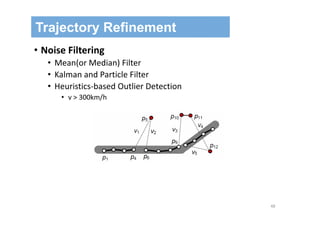
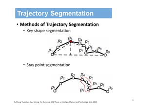
![68
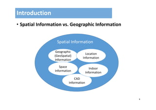
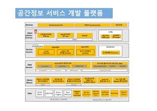
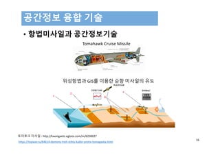
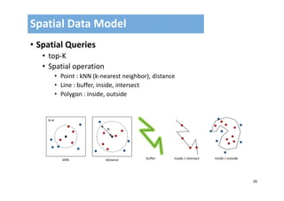
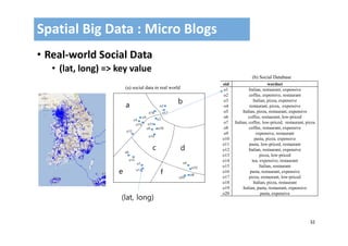
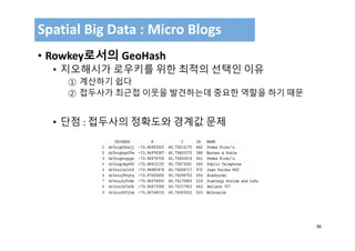
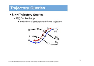
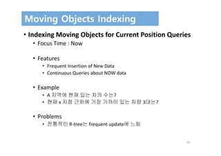
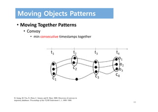
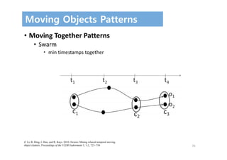
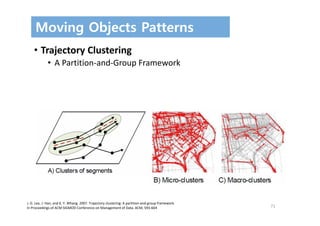
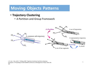
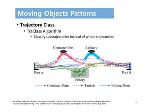
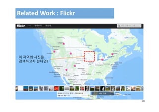
Moving Objects Patterns
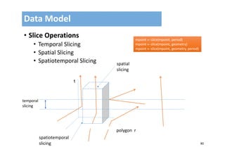
• Moving Together Patterns
• Flock
• 특정 Region r내에서 m 개체이상이 같은 방향으로 움직임
• Leadership
• 가장 먼저 움직인 객체
• Convergence
• m 개체 이상이 같은 방향으로
• Encounter
• r내에서 만나는 지역
[37] J. Gudmundsson and M.V. Kreveld. 2006. Computing longest duration flocks in
trajectory data. In Proceedings of the 14th Annual ACM International Symposium on
Advances in Geographic Information Systems. ACM, 35‐42.
[38] J. Gudmundsson, M.V. Kreveld, and B. Speckmann. 2004. Efficient detection of
motion patterns in spatio‐temporal data sets. In Proceedings of the 12th Annual
ACM International Symposium on Advances in Geographic Information Systems.
ACM, 250–257.](https://image.slidesharecdn.com/kaistv02-170929093337/85/Moving-Objects-and-Spatial-Data-Computing-68-320.jpg)

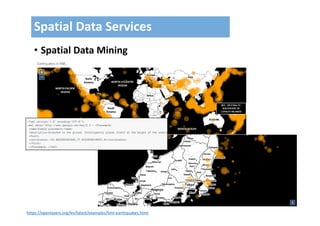
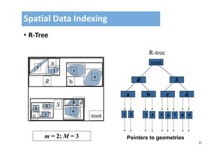
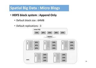
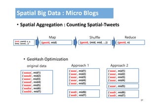
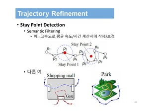
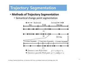
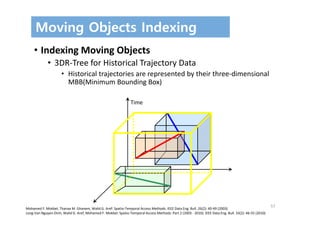
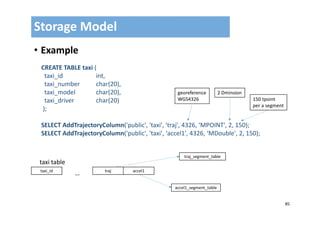
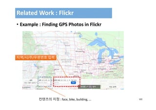
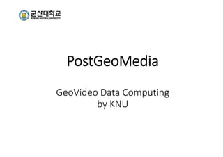
![77
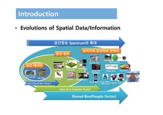
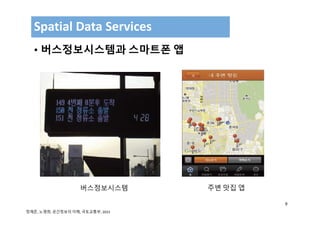
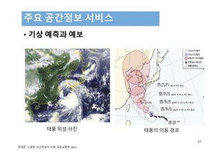
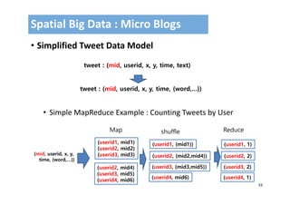
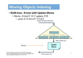
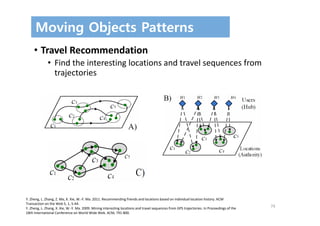
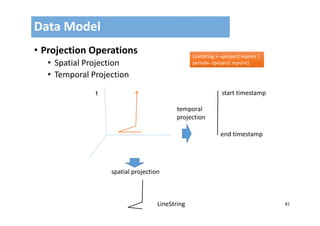
• Data Type
• TPoint and TDouble
• TPoint : (Point, Timestamp)
• TDouble : (Double, Timestamp)
• TBool : (Boolean, Timestamp )
• MPoint
• TPoint[]
• MDouble
• TDouble[]
• MBool
• TBool[]
Data Model](https://image.slidesharecdn.com/kaistv02-170929093337/85/Moving-Objects-and-Spatial-Data-Computing-77-320.jpg)
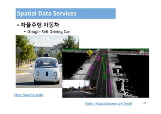
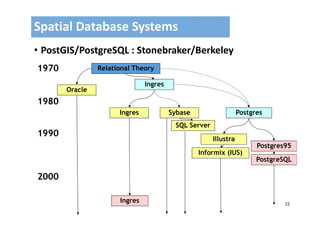
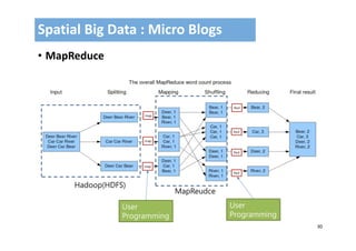
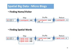
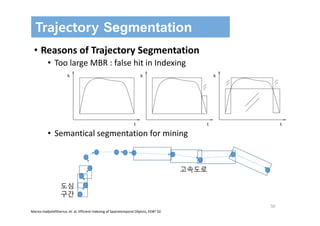
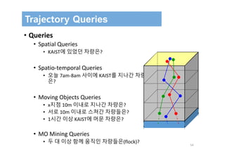
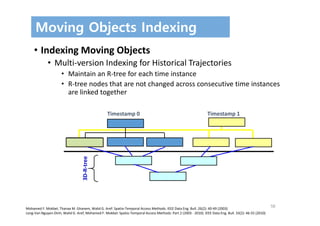
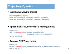
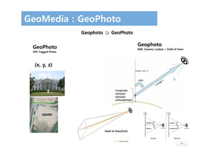
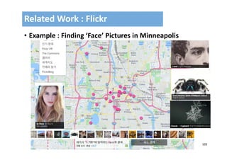
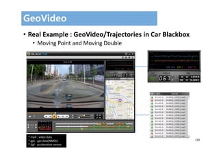
![78
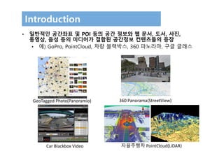
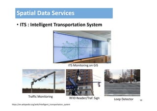
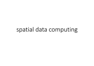
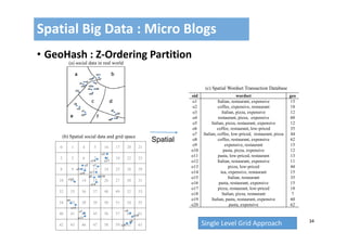
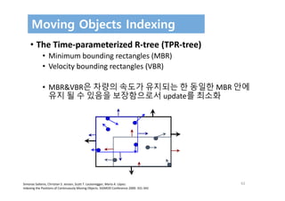
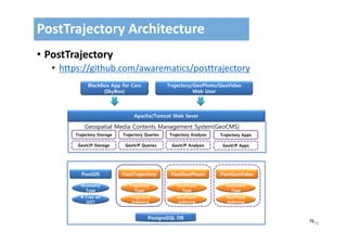
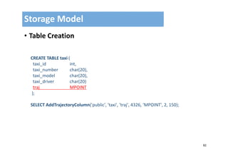
• Data Type and Operations
Data Model
t
x
distance : moving double
MDouble
MPoint
MBool : is Intersect?
false[t1], false[t2], true[t3) …](https://image.slidesharecdn.com/kaistv02-170929093337/85/Moving-Objects-and-Spatial-Data-Computing-78-320.jpg)
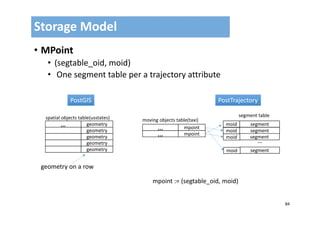
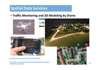
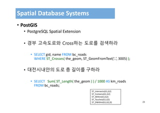
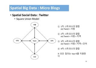
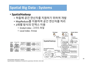
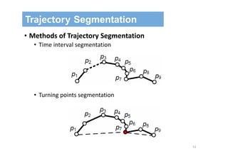
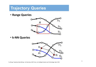
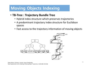
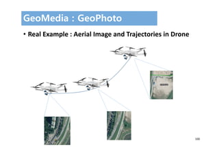
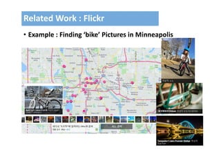
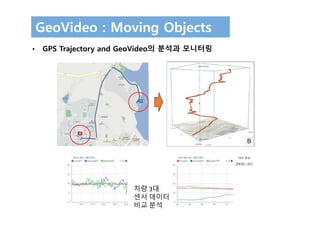
![86
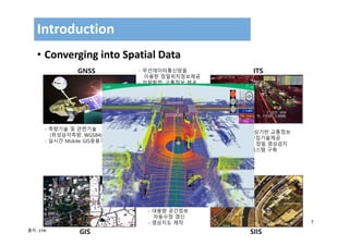
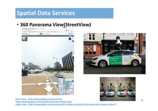
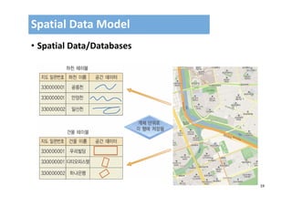
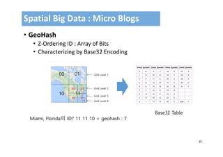
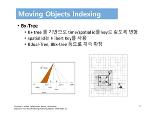
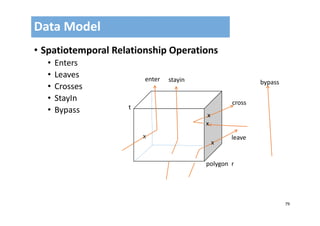
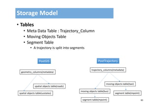
• Segment Table
• strategies
• split
• count‐based‐split(*)
• spatial‐based‐split
• temporal‐based‐split
• st‐based‐split
• compression
• no compression : tpoint[]
• naïve compression : zip
• simplification
Storage Model
moid segid tpcount rect start_time end_time tpseg
box2d timestamp tpoint[]](https://image.slidesharecdn.com/kaistv02-170929093337/85/Moving-Objects-and-Spatial-Data-Computing-86-320.jpg)


This document summarizes a presentation on moving objects and spatial data computing. It discusses spatial data types including location data from GPS, images, videos, sensors and more. Spatial data is increasingly integrated with multimedia content. Technologies like Google Street View, drones, autonomous vehicles, and black boxes in cars generate large amounts of spatial and multimedia data. Hadoop and Spatial databases like PostGIS are important for analyzing spatial big data from social media.


![[FOSS4G KOREA 2014]Hadoop 상에서 MapReduce를 이용한 Spatial Big Data 집계와 시스템 구축](https://cdn.slidesharecdn.com/ss_thumbnails/foss4g2014hadoop-geohash-v02-140829035316-phpapp02-thumbnail.jpg?width=640&height=640&fit=bounds)


![[SSA] 04.sql on hadoop(2014.02.05)](https://cdn.slidesharecdn.com/ss_thumbnails/04-140225072610-phpapp01-thumbnail.jpg?width=640&height=640&fit=bounds)


![[공간정보시스템 개론] L04 항공사진의 이해](https://cdn.slidesharecdn.com/ss_thumbnails/l04-170314115042-thumbnail.jpg?width=640&height=640&fit=bounds)
![[공간정보시스템 개론] L03 지구의형상과좌표체계](https://cdn.slidesharecdn.com/ss_thumbnails/l03-170314115023-thumbnail.jpg?width=640&height=640&fit=bounds)
![[공간정보시스템 개론] L02 공간정보와 지리정보](https://cdn.slidesharecdn.com/ss_thumbnails/l02-170314114945-thumbnail.jpg?width=640&height=640&fit=bounds)
![[공간정보시스템 개론] L01 공간정보시스템개요](https://cdn.slidesharecdn.com/ss_thumbnails/l01-170314114926-thumbnail.jpg?width=640&height=640&fit=bounds)
![[공간정보시스템 개론] L12 공간정보분석](https://cdn.slidesharecdn.com/ss_thumbnails/l12-170314114828-thumbnail.jpg?width=640&height=640&fit=bounds)
![[공간정보시스템 개론] L11 공간정보의 구축](https://cdn.slidesharecdn.com/ss_thumbnails/l11-170314114751-thumbnail.jpg?width=640&height=640&fit=bounds)
![[공간정보시스템 개론] L10 수치표고모델](https://cdn.slidesharecdn.com/ss_thumbnails/l10-170314114727-thumbnail.jpg?width=640&height=640&fit=bounds)
![[공간정보시스템 개론] L09 공간 데이터 모델](https://cdn.slidesharecdn.com/ss_thumbnails/l09-170314114718-thumbnail.jpg?width=640&height=640&fit=bounds)
![[공간정보시스템 개론] L08 gnss의 개념과 활용](https://cdn.slidesharecdn.com/ss_thumbnails/l08gnss-170314114625-thumbnail.jpg?width=640&height=640&fit=bounds)
![[공간정보시스템 개론] L07 원격탐사의 개념과 활용](https://cdn.slidesharecdn.com/ss_thumbnails/l07-170314114620-thumbnail.jpg?width=640&height=640&fit=bounds)
![[공간정보시스템 개론] L06 GIS의 이해](https://cdn.slidesharecdn.com/ss_thumbnails/l06gis-170314114559-thumbnail.jpg?width=640&height=640&fit=bounds)
![[공간정보시스템 개론] L05 우리나라의 수치지도](https://cdn.slidesharecdn.com/ss_thumbnails/l05-170314114527-thumbnail.jpg?width=640&height=640&fit=bounds)


![谷歌留痕技术教程[ 𝙩𝙤𝙥 𝟮𝟯𝟯. 𝙘 𝙤𝙢 ]](https://cdn.slidesharecdn.com/ss_thumbnails/top233-260130173900-2eb784f9-thumbnail.jpg?width=640&height=640&fit=bounds)


![20260201 [FOSDEM] gomodjail - library sandboxing for Go modules.pdf](https://cdn.slidesharecdn.com/ss_thumbnails/20260201fosdemgomodjail-librarysandboxingforgomodules-260201225659-76609ec4-thumbnail.jpg?width=640&height=640&fit=bounds)


