SlideShare a Scribd company logo
Revisit to Baronga Islands, Yakhine,
West Myanmar
50km
Baronga Islands
Kyi Khin and Aung Moe, 2015
N
A
B
A’
A
Rangin, 2013Bertrand & Rangin, 2003
Structural and Tectonic maps of Myanmar
Regional Geological Map of Baronga Islands, Yakhine, Myanmar (Kyi Khin et al., 2014)
1
1
2
2
3
3
4
4
5
5
6
6
Detailed outcrop mapping
Sittwe Pauktaw
Middle Baronga
Syncline
10km
N
East Baronga Island
West Baronga Island
Strike-slip Faults at eastern part of Middle Baronga Island
?
Middle Baronga
Syncline
20km
10kmBaronga Islands
East Baronga Island
West Baronga Island
Minor Cross-Faults at Middle Baronga and Clastic dyke near Cross-Fault at East Baronga Is.
Middle Baronga
Syncline
20km
10kmBaronga Islands
East Baronga Island
West Baronga Island
Syn-sedimentary fold and faulted contact at Sittwe point
Middle Baronga
Syncline
20km
10km
Baronga Islands
East Baronga Island
Minor Cross-Faults and slope scars at West Baronga Island
West
Baronga
Island
Laychat taung Island
Slump Folds in Laung
Formation
(Lower Miocene)
at Sittwe PointNote: Photo taken towards South
DF
DF
Laychat Taung Island (off-Sittwe Point)
DF: Debris Flow
Conglomerates
CS: Channel Sandbody
AS: Alternated Sandstones
(Levee deposits)
Interpretation
Submarine slope
deposits containing
submarine channels
based with debris flows
and, levee deposits
N
Slump folds in Middle Baronga Island
Note: Photo taken towards South
Note: Photo taken towards NorthNote: Photo taken towards East
Note: Photo taken towards West
Regional Structure Development
Shillong Massif
Figure (A)
Figure (B)
Present Structural development of Surma Basin, Bengladesh with the interpretation of the superposed
regional folding related to Himalayan orogenic movements (A) and its three dimensional model explanation
(B).
• Regional scale development of dome and basin pattern in Bangladesh and Yakhine
coastal strip (Myanmar) is shown by Hiller and Elahi (1984), Tappan (1990) and
Gani and Alam (1999). Now a day those of structures can be easily recognised
satellite image by Google Earth.
• In the figure (A) dome and basin pattern of Surma Basin (Bangladesh) (Hiller and
Elahi 1984) is used as a model for interpretation of deformation. By joining the lines
of dome and basin, the traces of the three sets of folds (F1, F2 and F3) can be
recognised. These dome and basin structures are called a superimposed folding
(Ramsay 1967) and interfering folding (Ghosh 1993).
• In the three dimension (Fig. B), the first folds (F1) show homoaxial cylindrical E-W
trend horizontal folds. The first folds become distorted and their limbs refolded
with new axial directions. Antiformal second folds are superposed across a first fold
antiform. There is a mutual culmination in both sets of folds resulting in the
formation of a dome like structure. Similarly crossing synforms produce mutual
depressions in both sets of fold axes and the development of a basin structure. As a
result of this interaction the surfaces are folded into a series of alternating domes
and basins, each basin surrounded by four domes, each dome by four basins.
Fig. D.Ridge and Valley development in
Bangal fan area.
Fig. C. Fold and fault development on the
Bangladesh and Yakhine coastal area.
F1 Fold
F2 Fold
CHARACTER OF FOLDS
• F1 fold is open and gentle. Therefore it was formed by slowly movement (4cm/year: Rangin
2012, Than Htut et al. 2012) with gently stop of Indian plate. F1 fold axis is trending generally
EW direction, which indicates to the northward movement of Indian plate. F1 folds are nearly
upright, symmetry and no vergency, shows the straight northward movement.
• The character of F1 fold distinctly shows that it was formed in the open area of the Bay of
Bangal unfolded sediments, intensive folding commences towards the N continental slope of
the Bay, which was followed the Indian plate northward movement. It was moved very slow
and regularly. When the movement was suddenly stopped by buttress with Shillong Massif
during the Miocene time Himalayan uplift (Uddin and Lundberg 1998), become folded.
Therefore F1 fold is open and gentle.
• F2 fold is narrow and tight. Therefore it was formed by the force of movement and pressed
by the Indian plate. The axis is trending NS direction, which indicates the eastward
propagation of Himalayan collision against to the buttress of Indo-Burman Ranges. F2 folds
are upright, symmetry and no vergency, shows the straight eastward movement.
• F2 fold shows the superimposed folding upon the F1 fold. It moved also slow and regularly,
but later become faster and butted with Indo-Burman Ranges. Therefore F2 fold is narrow
and tight.
• In the F2 fold, Miocene sediments are folded together with Mio-Pliocene sediment. F2 fold
was formed during the Pliocene-Pleistocene eastward propagation of Himalayan collision.
• F3 fold is distinctly found near the Shillong Massif. Along Dauki fault Shillong Massif was
moved eastward by force of Indian plate movement and dragged the folded Bangel fan area.
• By this movement, Kaladan fault and Chittagong coastal fault could be formed as right-lateral
strike slip movement (Rangin,2012).
FOLD GEOMETRY AND STEREOPLOT
Fig. E. Equal-area Stereonet plot of Sittwe and Barong Islands.
Black coloured half-circles= Bedding (S0) 245˚/60˚ F2 folds; Red coloured half-circle=Bedding (S0) 360˚/15˚
or 180˚/15˚ F1 folds.
1. Restoration of Plunge Angle=30˚, 2. Restoration of F2 fold dipping = 60˚ and 3. Construction of F1 fold
limb=15˚
Strike-slip motion (Extension)
Oblique Motion (Crustal shortening)
Sketches showing NW-SE trend double plunging Folds which as a model
of the slump structures development in Syn-Sedimenatary deposition of
paleo-submarine slope deposits in Baronga Islands , Yakhine, Myanmar
Paleo-Slope trends from Gutter Casts direction
SW
SSE
Lr. Mio
Mid. Mio
Bangladesh
N
Conclusion
• NW-SE Trended Faults developed by of riedel shear
movement and sub-parallel with Kaladan and Chittagaung
Coastal Faults
• Paleo-slope Trend in Lower Miocene show SW and changed
SSE in Middle Miocene
• Slump folds were formed by syn-sedimentary deformation
including gravity sliding at eastern Bengal paleo-slope
• Double plunging folds were developed by NE-SW oblique
subduction of India Plate and later right-lateral strike slip
extension
Thank You

More Related Content

What's hot

Geology-2016-Malusà et al-G37407.1
Geology-2016-Malusà et al-G37407.1Geology-2016-Malusà et al-G37407.1
Geology-2016-Malusà et al-G37407.1
Laura Dafov
 
Geochemistry of lamprophyre dykes in the Eastern Desert of Egypt
Geochemistry of lamprophyre dykes in the Eastern Desert of EgyptGeochemistry of lamprophyre dykes in the Eastern Desert of Egypt
Geochemistry of lamprophyre dykes in the Eastern Desert of Egypt
Dr. Ibr@him
 
Comparative Study Between Some Uraniferous Volcanic Rocks, Eastern Desert, Egypt
Comparative Study Between Some Uraniferous Volcanic Rocks, Eastern Desert, EgyptComparative Study Between Some Uraniferous Volcanic Rocks, Eastern Desert, Egypt
Comparative Study Between Some Uraniferous Volcanic Rocks, Eastern Desert, Egypt
Dr. Ibr@him
 
San Juan Volcanic Field - Nested Caldera Study
San Juan Volcanic Field - Nested Caldera StudySan Juan Volcanic Field - Nested Caldera Study
San Juan Volcanic Field - Nested Caldera Study
Johanna Vaughan
 
Arakan coastal ranges, kyi khin & and khin zaw, 2017.pptx
Arakan coastal ranges, kyi khin & and khin zaw, 2017.pptx Arakan coastal ranges, kyi khin & and khin zaw, 2017.pptx
Arakan coastal ranges, kyi khin & and khin zaw, 2017.pptx
KYI KHIN
 

What's hot (19)

Geochemical characteristics of granitoids (ho gneiss) from the pan – african ...
Geochemical characteristics of granitoids (ho gneiss) from the pan – african ...Geochemical characteristics of granitoids (ho gneiss) from the pan – african ...
Geochemical characteristics of granitoids (ho gneiss) from the pan – african ...
 
Geology-2016-Malusà et al-G37407.1
Geology-2016-Malusà et al-G37407.1Geology-2016-Malusà et al-G37407.1
Geology-2016-Malusà et al-G37407.1
 
S11076243_FIELD_REPORT
S11076243_FIELD_REPORTS11076243_FIELD_REPORT
S11076243_FIELD_REPORT
 
Geochemistry of lamprophyre dykes in the Eastern Desert of Egypt
Geochemistry of lamprophyre dykes in the Eastern Desert of EgyptGeochemistry of lamprophyre dykes in the Eastern Desert of Egypt
Geochemistry of lamprophyre dykes in the Eastern Desert of Egypt
 
Structural Geology and Geomorphology through Remote Sensing
Structural Geology and Geomorphology through Remote SensingStructural Geology and Geomorphology through Remote Sensing
Structural Geology and Geomorphology through Remote Sensing
 
Dr. Andri Slamet Subandrio - The future of mineral exploration beyond Sunda c...
Dr. Andri Slamet Subandrio - The future of mineral exploration beyond Sunda c...Dr. Andri Slamet Subandrio - The future of mineral exploration beyond Sunda c...
Dr. Andri Slamet Subandrio - The future of mineral exploration beyond Sunda c...
 
Structural Mapping using GIS/RS
Structural Mapping using GIS/RSStructural Mapping using GIS/RS
Structural Mapping using GIS/RS
 
Festa et al., 2013 - Draft
Festa et al., 2013 - DraftFesta et al., 2013 - Draft
Festa et al., 2013 - Draft
 
Paleodepositional environment and sequence stratigraphy of outcropping sedime...
Paleodepositional environment and sequence stratigraphy of outcropping sedime...Paleodepositional environment and sequence stratigraphy of outcropping sedime...
Paleodepositional environment and sequence stratigraphy of outcropping sedime...
 
Comparative Study Between Some Uraniferous Volcanic Rocks, Eastern Desert, Egypt
Comparative Study Between Some Uraniferous Volcanic Rocks, Eastern Desert, EgyptComparative Study Between Some Uraniferous Volcanic Rocks, Eastern Desert, Egypt
Comparative Study Between Some Uraniferous Volcanic Rocks, Eastern Desert, Egypt
 
pendekatan tektonik indonesia Geologi Pngea UPN
 pendekatan tektonik indonesia Geologi Pngea UPN  pendekatan tektonik indonesia Geologi Pngea UPN
pendekatan tektonik indonesia Geologi Pngea UPN
 
San Juan Volcanic Field - Nested Caldera Study
San Juan Volcanic Field - Nested Caldera StudySan Juan Volcanic Field - Nested Caldera Study
San Juan Volcanic Field - Nested Caldera Study
 
quartoo sand
quartoo sandquartoo sand
quartoo sand
 
Simulation of tsunami generation, propagation and coastal inundation in the E...
Simulation of tsunami generation, propagation and coastal inundation in the E...Simulation of tsunami generation, propagation and coastal inundation in the E...
Simulation of tsunami generation, propagation and coastal inundation in the E...
 
Wilson200722222222222
Wilson200722222222222Wilson200722222222222
Wilson200722222222222
 
Balasore report
Balasore reportBalasore report
Balasore report
 
Petford199422222222222222
Petford199422222222222222Petford199422222222222222
Petford199422222222222222
 
Arboit et al_2017
Arboit et al_2017Arboit et al_2017
Arboit et al_2017
 
Arakan coastal ranges, kyi khin & and khin zaw, 2017.pptx
Arakan coastal ranges, kyi khin & and khin zaw, 2017.pptx Arakan coastal ranges, kyi khin & and khin zaw, 2017.pptx
Arakan coastal ranges, kyi khin & and khin zaw, 2017.pptx
 

Viewers also liked (6)

ミャンマーの地質(English version)
ミャンマーの地質(English version)ミャンマーの地質(English version)
ミャンマーの地質(English version)
 
Some Microscopic features of Volcaniclastic Rocks in Jurong Formation, Singapore
Some Microscopic features of Volcaniclastic Rocks in Jurong Formation, SingaporeSome Microscopic features of Volcaniclastic Rocks in Jurong Formation, Singapore
Some Microscopic features of Volcaniclastic Rocks in Jurong Formation, Singapore
 
Neogene sedimentary fringe (2012)
Neogene sedimentary fringe (2012)Neogene sedimentary fringe (2012)
Neogene sedimentary fringe (2012)
 
Field trip to Aso volcano, Kyushu, Japan
Field trip to Aso volcano, Kyushu, JapanField trip to Aso volcano, Kyushu, Japan
Field trip to Aso volcano, Kyushu, Japan
 
Core orientation in drilling of ROCKS for Site Investigation Works
Core orientation in drilling of ROCKS for Site Investigation WorksCore orientation in drilling of ROCKS for Site Investigation Works
Core orientation in drilling of ROCKS for Site Investigation Works
 
LANDSLIDES
LANDSLIDESLANDSLIDES
LANDSLIDES
 

Similar to Revisit to Baronga Islands, KyiKhin & AungMoe, 2015 (Rev. 3)

ICP.000526.pdf
ICP.000526.pdfICP.000526.pdf
Bouguer anomaly and free-air anomaly correlation signatures in parts of Benue...
Bouguer anomaly and free-air anomaly correlation signatures in parts of Benue...Bouguer anomaly and free-air anomaly correlation signatures in parts of Benue...
Bouguer anomaly and free-air anomaly correlation signatures in parts of Benue...
Premier Publishers
 
presentation on geological structure.pptx
presentation on geological structure.pptxpresentation on geological structure.pptx
presentation on geological structure.pptx
AlMamun560346
 

Similar to Revisit to Baronga Islands, KyiKhin & AungMoe, 2015 (Rev. 3) (20)

ICP.000526.pdf
ICP.000526.pdfICP.000526.pdf
ICP.000526.pdf
 
Tectonic Framework Tectonic Framework of Bengal Basin.pptx
Tectonic Framework Tectonic Framework of Bengal Basin.pptxTectonic Framework Tectonic Framework of Bengal Basin.pptx
Tectonic Framework Tectonic Framework of Bengal Basin.pptx
 
Regional Tectonic Features, Processes and elements.
Regional Tectonic Features, Processes and elements.Regional Tectonic Features, Processes and elements.
Regional Tectonic Features, Processes and elements.
 
Structural Feild trip Write Up
Structural Feild trip Write UpStructural Feild trip Write Up
Structural Feild trip Write Up
 
Morley alvey 2015 final
Morley alvey 2015 finalMorley alvey 2015 final
Morley alvey 2015 final
 
Tectono-magmatic Development of Accreted West Burma Block from Gondwana Land-...
Tectono-magmatic Development of Accreted West Burma Block from Gondwana Land-...Tectono-magmatic Development of Accreted West Burma Block from Gondwana Land-...
Tectono-magmatic Development of Accreted West Burma Block from Gondwana Land-...
 
chapter5.pptx
chapter5.pptxchapter5.pptx
chapter5.pptx
 
Fold & its classification
Fold & its classificationFold & its classification
Fold & its classification
 
G05732933
G05732933G05732933
G05732933
 
Geologicalsettingpalkbay
GeologicalsettingpalkbayGeologicalsettingpalkbay
Geologicalsettingpalkbay
 
Bouguer anomaly and free-air anomaly correlation signatures in parts of Benue...
Bouguer anomaly and free-air anomaly correlation signatures in parts of Benue...Bouguer anomaly and free-air anomaly correlation signatures in parts of Benue...
Bouguer anomaly and free-air anomaly correlation signatures in parts of Benue...
 
document.pdf
document.pdfdocument.pdf
document.pdf
 
Deformasi batuan
Deformasi batuanDeformasi batuan
Deformasi batuan
 
Earthquake presentation
Earthquake presentationEarthquake presentation
Earthquake presentation
 
presentation on geological structure.pptx
presentation on geological structure.pptxpresentation on geological structure.pptx
presentation on geological structure.pptx
 
Structural Geology for Civil Engineering
Structural Geology for Civil EngineeringStructural Geology for Civil Engineering
Structural Geology for Civil Engineering
 
Earth movements
Earth movementsEarth movements
Earth movements
 
Stuctural geology
Stuctural geologyStuctural geology
Stuctural geology
 
2D seismic interpretation and petrophysical analysis of kabirwala area, centr...
2D seismic interpretation and petrophysical analysis of kabirwala area, centr...2D seismic interpretation and petrophysical analysis of kabirwala area, centr...
2D seismic interpretation and petrophysical analysis of kabirwala area, centr...
 
Group-5-Report-EDITED.pptx
Group-5-Report-EDITED.pptxGroup-5-Report-EDITED.pptx
Group-5-Report-EDITED.pptx
 

More from KYI KHIN

Bed Rock Slides in Shimanto Belt_Kyi Khin & Fukuda, 2001, 17th Applied geolog...
Bed Rock Slides in Shimanto Belt_Kyi Khin & Fukuda, 2001, 17th Applied geolog...Bed Rock Slides in Shimanto Belt_Kyi Khin & Fukuda, 2001, 17th Applied geolog...
Bed Rock Slides in Shimanto Belt_Kyi Khin & Fukuda, 2001, 17th Applied geolog...
KYI KHIN
 
GEOTECHNICAL INVESTIGATIONS
GEOTECHNICAL INVESTIGATIONSGEOTECHNICAL INVESTIGATIONS
GEOTECHNICAL INVESTIGATIONS
KYI KHIN
 
Understanding the sedimentary rocks - Geotalk 2 (MGSS)
Understanding the sedimentary rocks - Geotalk 2 (MGSS)Understanding the sedimentary rocks - Geotalk 2 (MGSS)
Understanding the sedimentary rocks - Geotalk 2 (MGSS)
KYI KHIN
 
Technical report on landslided, kyushu, japan (2006) in japanese
Technical report on landslided, kyushu, japan (2006) in japaneseTechnical report on landslided, kyushu, japan (2006) in japanese
Technical report on landslided, kyushu, japan (2006) in japanese
KYI KHIN
 

More from KYI KHIN (8)

Role of Geologists in Natural Hazard Mapping and Application_Dr Kyi Khin_MGSS...
Role of Geologists in Natural Hazard Mapping and Application_Dr Kyi Khin_MGSS...Role of Geologists in Natural Hazard Mapping and Application_Dr Kyi Khin_MGSS...
Role of Geologists in Natural Hazard Mapping and Application_Dr Kyi Khin_MGSS...
 
Outcrops of SG_KK & KL_August 2016_Final_20.09.16
Outcrops of SG_KK & KL_August 2016_Final_20.09.16Outcrops of SG_KK & KL_August 2016_Final_20.09.16
Outcrops of SG_KK & KL_August 2016_Final_20.09.16
 
Bed Rock Slides in Shimanto Belt_Kyi Khin & Fukuda, 2001, 17th Applied geolog...
Bed Rock Slides in Shimanto Belt_Kyi Khin & Fukuda, 2001, 17th Applied geolog...Bed Rock Slides in Shimanto Belt_Kyi Khin & Fukuda, 2001, 17th Applied geolog...
Bed Rock Slides in Shimanto Belt_Kyi Khin & Fukuda, 2001, 17th Applied geolog...
 
GEOTECHNICAL INVESTIGATIONS
GEOTECHNICAL INVESTIGATIONSGEOTECHNICAL INVESTIGATIONS
GEOTECHNICAL INVESTIGATIONS
 
Understanding the sedimentary rocks - Geotalk 2 (MGSS)
Understanding the sedimentary rocks - Geotalk 2 (MGSS)Understanding the sedimentary rocks - Geotalk 2 (MGSS)
Understanding the sedimentary rocks - Geotalk 2 (MGSS)
 
Arbura formation (forced regressive sequences) kyushu, japan 2005
Arbura formation (forced regressive sequences) kyushu, japan 2005Arbura formation (forced regressive sequences) kyushu, japan 2005
Arbura formation (forced regressive sequences) kyushu, japan 2005
 
Rocks of Singapore (2013)
Rocks of Singapore (2013)Rocks of Singapore (2013)
Rocks of Singapore (2013)
 
Technical report on landslided, kyushu, japan (2006) in japanese
Technical report on landslided, kyushu, japan (2006) in japaneseTechnical report on landslided, kyushu, japan (2006) in japanese
Technical report on landslided, kyushu, japan (2006) in japanese
 

Recently uploaded

Recently uploaded (20)

Advances in production technology of Grapes.pdf
Advances in production technology of Grapes.pdfAdvances in production technology of Grapes.pdf
Advances in production technology of Grapes.pdf
 
B.ed spl. HI pdusu exam paper-2023-24.pdf
B.ed spl. HI pdusu exam paper-2023-24.pdfB.ed spl. HI pdusu exam paper-2023-24.pdf
B.ed spl. HI pdusu exam paper-2023-24.pdf
 
Basic Civil Engg Notes_Chapter-6_Environment Pollution & Engineering
Basic Civil Engg Notes_Chapter-6_Environment Pollution & EngineeringBasic Civil Engg Notes_Chapter-6_Environment Pollution & Engineering
Basic Civil Engg Notes_Chapter-6_Environment Pollution & Engineering
 
How to Split Bills in the Odoo 17 POS Module
How to Split Bills in the Odoo 17 POS ModuleHow to Split Bills in the Odoo 17 POS Module
How to Split Bills in the Odoo 17 POS Module
 
Palestine last event orientationfvgnh .pptx
Palestine last event orientationfvgnh .pptxPalestine last event orientationfvgnh .pptx
Palestine last event orientationfvgnh .pptx
 
50 ĐỀ LUYỆN THI IOE LỚP 9 - NĂM HỌC 2022-2023 (CÓ LINK HÌNH, FILE AUDIO VÀ ĐÁ...
50 ĐỀ LUYỆN THI IOE LỚP 9 - NĂM HỌC 2022-2023 (CÓ LINK HÌNH, FILE AUDIO VÀ ĐÁ...50 ĐỀ LUYỆN THI IOE LỚP 9 - NĂM HỌC 2022-2023 (CÓ LINK HÌNH, FILE AUDIO VÀ ĐÁ...
50 ĐỀ LUYỆN THI IOE LỚP 9 - NĂM HỌC 2022-2023 (CÓ LINK HÌNH, FILE AUDIO VÀ ĐÁ...
 
aaaaaaaaaaaaaaaaaaaaaaaaaaaaaaaaaaaaaaaaaaaaaaaaaaaaaaa
aaaaaaaaaaaaaaaaaaaaaaaaaaaaaaaaaaaaaaaaaaaaaaaaaaaaaaaaaaaaaaaaaaaaaaaaaaaaaaaaaaaaaaaaaaaaaaaaaaaaaaaaaaaaaa
aaaaaaaaaaaaaaaaaaaaaaaaaaaaaaaaaaaaaaaaaaaaaaaaaaaaaaa
 
Matatag-Curriculum and the 21st Century Skills Presentation.pptx
Matatag-Curriculum and the 21st Century Skills Presentation.pptxMatatag-Curriculum and the 21st Century Skills Presentation.pptx
Matatag-Curriculum and the 21st Century Skills Presentation.pptx
 
Salient features of Environment protection Act 1986.pptx
Salient features of Environment protection Act 1986.pptxSalient features of Environment protection Act 1986.pptx
Salient features of Environment protection Act 1986.pptx
 
Introduction to Quality Improvement Essentials
Introduction to Quality Improvement EssentialsIntroduction to Quality Improvement Essentials
Introduction to Quality Improvement Essentials
 
UNIT – IV_PCI Complaints: Complaints and evaluation of complaints, Handling o...
UNIT – IV_PCI Complaints: Complaints and evaluation of complaints, Handling o...UNIT – IV_PCI Complaints: Complaints and evaluation of complaints, Handling o...
UNIT – IV_PCI Complaints: Complaints and evaluation of complaints, Handling o...
 
NLC-2024-Orientation-for-RO-SDO (1).pptx
NLC-2024-Orientation-for-RO-SDO (1).pptxNLC-2024-Orientation-for-RO-SDO (1).pptx
NLC-2024-Orientation-for-RO-SDO (1).pptx
 
MARUTI SUZUKI- A Successful Joint Venture in India.pptx
MARUTI SUZUKI- A Successful Joint Venture in India.pptxMARUTI SUZUKI- A Successful Joint Venture in India.pptx
MARUTI SUZUKI- A Successful Joint Venture in India.pptx
 
Solid waste management & Types of Basic civil Engineering notes by DJ Sir.pptx
Solid waste management & Types of Basic civil Engineering notes by DJ Sir.pptxSolid waste management & Types of Basic civil Engineering notes by DJ Sir.pptx
Solid waste management & Types of Basic civil Engineering notes by DJ Sir.pptx
 
Basic Civil Engineering Notes of Chapter-6, Topic- Ecosystem, Biodiversity G...
Basic Civil Engineering Notes of Chapter-6,  Topic- Ecosystem, Biodiversity G...Basic Civil Engineering Notes of Chapter-6,  Topic- Ecosystem, Biodiversity G...
Basic Civil Engineering Notes of Chapter-6, Topic- Ecosystem, Biodiversity G...
 
Ethnobotany and Ethnopharmacology ......
Ethnobotany and Ethnopharmacology ......Ethnobotany and Ethnopharmacology ......
Ethnobotany and Ethnopharmacology ......
 
aaaaaaaaaaaaaaaaaaaaaaaaaaaaaaaaaaaaaaaaa
aaaaaaaaaaaaaaaaaaaaaaaaaaaaaaaaaaaaaaaaaaaaaaaaaaaaaaaaaaaaaaaaaaaaaaaaaaaaaaaaaa
aaaaaaaaaaaaaaaaaaaaaaaaaaaaaaaaaaaaaaaaa
 
How to Break the cycle of negative Thoughts
How to Break the cycle of negative ThoughtsHow to Break the cycle of negative Thoughts
How to Break the cycle of negative Thoughts
 
Phrasal Verbs.XXXXXXXXXXXXXXXXXXXXXXXXXX
Phrasal Verbs.XXXXXXXXXXXXXXXXXXXXXXXXXXPhrasal Verbs.XXXXXXXXXXXXXXXXXXXXXXXXXX
Phrasal Verbs.XXXXXXXXXXXXXXXXXXXXXXXXXX
 
Instructions for Submissions thorugh G- Classroom.pptx
Instructions for Submissions thorugh G- Classroom.pptxInstructions for Submissions thorugh G- Classroom.pptx
Instructions for Submissions thorugh G- Classroom.pptx
 

Revisit to Baronga Islands, KyiKhin & AungMoe, 2015 (Rev. 3)

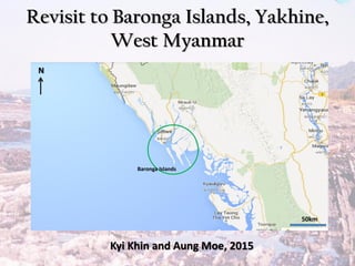
  • 1. Revisit to Baronga Islands, Yakhine, West Myanmar 50km Baronga Islands Kyi Khin and Aung Moe, 2015 N
  • 2. A B A’ A Rangin, 2013Bertrand & Rangin, 2003 Structural and Tectonic maps of Myanmar
  • 3. Regional Geological Map of Baronga Islands, Yakhine, Myanmar (Kyi Khin et al., 2014)
  • 5. Middle Baronga Syncline 10km N East Baronga Island West Baronga Island Strike-slip Faults at eastern part of Middle Baronga Island ?
  • 6. Middle Baronga Syncline 20km 10kmBaronga Islands East Baronga Island West Baronga Island Minor Cross-Faults at Middle Baronga and Clastic dyke near Cross-Fault at East Baronga Is.
  • 7. Middle Baronga Syncline 20km 10kmBaronga Islands East Baronga Island West Baronga Island Syn-sedimentary fold and faulted contact at Sittwe point
  • 8. Middle Baronga Syncline 20km 10km Baronga Islands East Baronga Island Minor Cross-Faults and slope scars at West Baronga Island West Baronga Island
  • 9. Laychat taung Island Slump Folds in Laung Formation (Lower Miocene) at Sittwe PointNote: Photo taken towards South
  • 10. DF DF Laychat Taung Island (off-Sittwe Point) DF: Debris Flow Conglomerates CS: Channel Sandbody AS: Alternated Sandstones (Levee deposits) Interpretation Submarine slope deposits containing submarine channels based with debris flows and, levee deposits N
  • 11. Slump folds in Middle Baronga Island Note: Photo taken towards South Note: Photo taken towards NorthNote: Photo taken towards East Note: Photo taken towards West
  • 12. Regional Structure Development Shillong Massif Figure (A) Figure (B) Present Structural development of Surma Basin, Bengladesh with the interpretation of the superposed regional folding related to Himalayan orogenic movements (A) and its three dimensional model explanation (B).
  • 13. • Regional scale development of dome and basin pattern in Bangladesh and Yakhine coastal strip (Myanmar) is shown by Hiller and Elahi (1984), Tappan (1990) and Gani and Alam (1999). Now a day those of structures can be easily recognised satellite image by Google Earth. • In the figure (A) dome and basin pattern of Surma Basin (Bangladesh) (Hiller and Elahi 1984) is used as a model for interpretation of deformation. By joining the lines of dome and basin, the traces of the three sets of folds (F1, F2 and F3) can be recognised. These dome and basin structures are called a superimposed folding (Ramsay 1967) and interfering folding (Ghosh 1993). • In the three dimension (Fig. B), the first folds (F1) show homoaxial cylindrical E-W trend horizontal folds. The first folds become distorted and their limbs refolded with new axial directions. Antiformal second folds are superposed across a first fold antiform. There is a mutual culmination in both sets of folds resulting in the formation of a dome like structure. Similarly crossing synforms produce mutual depressions in both sets of fold axes and the development of a basin structure. As a result of this interaction the surfaces are folded into a series of alternating domes and basins, each basin surrounded by four domes, each dome by four basins.
  • 14. Fig. D.Ridge and Valley development in Bangal fan area. Fig. C. Fold and fault development on the Bangladesh and Yakhine coastal area. F1 Fold F2 Fold
  • 15. CHARACTER OF FOLDS • F1 fold is open and gentle. Therefore it was formed by slowly movement (4cm/year: Rangin 2012, Than Htut et al. 2012) with gently stop of Indian plate. F1 fold axis is trending generally EW direction, which indicates to the northward movement of Indian plate. F1 folds are nearly upright, symmetry and no vergency, shows the straight northward movement. • The character of F1 fold distinctly shows that it was formed in the open area of the Bay of Bangal unfolded sediments, intensive folding commences towards the N continental slope of the Bay, which was followed the Indian plate northward movement. It was moved very slow and regularly. When the movement was suddenly stopped by buttress with Shillong Massif during the Miocene time Himalayan uplift (Uddin and Lundberg 1998), become folded. Therefore F1 fold is open and gentle. • F2 fold is narrow and tight. Therefore it was formed by the force of movement and pressed by the Indian plate. The axis is trending NS direction, which indicates the eastward propagation of Himalayan collision against to the buttress of Indo-Burman Ranges. F2 folds are upright, symmetry and no vergency, shows the straight eastward movement. • F2 fold shows the superimposed folding upon the F1 fold. It moved also slow and regularly, but later become faster and butted with Indo-Burman Ranges. Therefore F2 fold is narrow and tight. • In the F2 fold, Miocene sediments are folded together with Mio-Pliocene sediment. F2 fold was formed during the Pliocene-Pleistocene eastward propagation of Himalayan collision. • F3 fold is distinctly found near the Shillong Massif. Along Dauki fault Shillong Massif was moved eastward by force of Indian plate movement and dragged the folded Bangel fan area. • By this movement, Kaladan fault and Chittagong coastal fault could be formed as right-lateral strike slip movement (Rangin,2012).
  • 16. FOLD GEOMETRY AND STEREOPLOT Fig. E. Equal-area Stereonet plot of Sittwe and Barong Islands. Black coloured half-circles= Bedding (S0) 245˚/60˚ F2 folds; Red coloured half-circle=Bedding (S0) 360˚/15˚ or 180˚/15˚ F1 folds. 1. Restoration of Plunge Angle=30˚, 2. Restoration of F2 fold dipping = 60˚ and 3. Construction of F1 fold limb=15˚
  • 17. Strike-slip motion (Extension) Oblique Motion (Crustal shortening) Sketches showing NW-SE trend double plunging Folds which as a model of the slump structures development in Syn-Sedimenatary deposition of paleo-submarine slope deposits in Baronga Islands , Yakhine, Myanmar Paleo-Slope trends from Gutter Casts direction SW SSE Lr. Mio Mid. Mio Bangladesh N
  • 18. Conclusion • NW-SE Trended Faults developed by of riedel shear movement and sub-parallel with Kaladan and Chittagaung Coastal Faults • Paleo-slope Trend in Lower Miocene show SW and changed SSE in Middle Miocene • Slump folds were formed by syn-sedimentary deformation including gravity sliding at eastern Bengal paleo-slope • Double plunging folds were developed by NE-SW oblique subduction of India Plate and later right-lateral strike slip extension