
Recommended
Recommended
More Related Content
Similar to Tectonic Framework Tectonic Framework of Bengal Basin.pptx
Similar to Tectonic Framework Tectonic Framework of Bengal Basin.pptx (20)
Recently uploaded
Recently uploaded (20)
Tectonic Framework Tectonic Framework of Bengal Basin.pptx
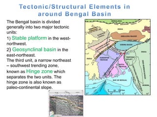
- 1. The Bengal basin is divided generally into two major tectonic units: 1) Stable platform in the west- northwest. 2) Geosynclinal basin in the east-northeast. The third unit, a narrow northeast – southwest trending zone, known as Hinge zone which separates the two units. The hinge zone is also known as paleo-continental slope.
- 2. The Bengal Basin became a remnant ocean basin (Graham et al., 1975; Ingersoll et al., 1995) (Fig.) at the beginning of Miocene because of the continuing oblique subduction of India beneath Burma (West Burma Block). The Bengal Basin, as a remnant ocean basin, has three distinct geo-tectonic provinces: (1) Passive to extensional cratonic margin in the west, the Stable Shelf Province; (2) the Central Deep Basin Province or the remnant basin; and (3) the subduction-related orogen in the east, the Chittagong-Tripura Fold Belt (CTFB) Province. These geo-tectonic provinces have been related to a regional plate tectonic scenario. Each of these provinces has its own distinctive tectonic and stratigraphic framework and history of basin-fill.
- 4. The stable platform refers to the stable shelf of Bengal basin, which is divided into three major zones: a.Northern slope of the Rangpur saddle b. Rangpur saddle (Dinajpur Block) c. Southern slope of the Rangpur saddle or western foreland shelf or Bengal shelf or Bogra shelf Rangpur Saddle represents Indian Platform and connects the Indian Shield with the shillong massif and the Mikir Hills. Shillong Massif is a large thrust block of the Indian Shield. In Rangpur Saddle the basement is the most uplifted and is covered with thin sedimentary deposits.
- 5. It is continental crust overlain by the sediments of Cretaceous to Recent times. - in isolated basin on the stable shelf, there are permo carboniferous sediments with considerable amount of Gondwana Coal. - The thickness of the upper part of the shelf is 130m and lower part of the shelf is 5000m.
- 6. The basement is shallowest in the Rangpur saddle (Dinajpur Block), from there the basement plunges greatly towards the south- southeast up to hinge zone, which is known as southern slope of Rangpur saddle (Dinajpur block) or the western foreland shelf. The plunge of the basement in the northwest towards the sub- Himalayan Foredeep is rather sharp and known as northern slope of Rangpur saddle.
- 7. Rangpur saddle: This structural feature is the part of north eastern prolongation of the Indian shield and separates the sub-Himalayan Foredeep in the north from the Bengal basin, particularly from the latter’s stable shelf in the south. The Rangpur saddle connects the main shield area with the Shillong Massif and Mikir Hills to the east. The results of gravimetry, seismic and aeromagnetic surveys as well as those of drilling reveal that the Rangpur saddle is overlain merely by Recent to sub-Recent deposits. However, there are also indications of N-S aligned graben structures with Gondwana fill.
- 8. The sedimentary cover on the Rangpur saddle is about 130m at the shallowest part in Maddhapara and is represented by Dupitila sandstone and Madhupur clay of Plio-Pleistocene age, while the thickness gradually increases to 700m both in north and in south direction. The tectonic boundary of the Rangpur saddle with the northern and southern slopes has been marked at 700m contour line on the basement. Here the sedimentary deposit form monoclinal beds with 10-20 dip. The width of Rangpur saddle is approximately 100km. It is connected with the Shillong Massif by a series of sub-meridional (N-S trending) trending faults.
- 9. According to Ameen et al (2007) the rock of the Dinajpur Block consist of a suite of tonalite and granodioritic rocks, various deformed to granitic gneiss and intruded by younger monzogranite. A tonalite obtained in this block at a depth of 227.48m in drill hole Bh-2 at Maddhapara records an age of 1722±6 Ma. Paleoproterozoic rocks with similar magnetic ages are unknown in the adjacent Indian Blocks of the Chhotanagpur Plateau (IS) or Shillong Massif. This lack of comparable ages may be due to the paucity of precise radiometric ages from the Indian Terrains or more likely, because there are real age differences, with the buried rock at Maddhapara. Representing a separate and discrete micro-continental fragment (Dinajpur Block) that was trapped by the northward migration of India during Gondwana dispersal.
- 10. NORTHERN SLOPE OF THE RANGPUR SADDLE AND SUB HIMALAYAN FOREDEEP: The basement of the northern slope of the Rangpur saddle (Dinajpur block) occasionally designated as Dinajpur slope, dips down to a depth of about 4000m and is covered mainly by the Siwaliks of Middle Miocene to Pleistocene age. The plunge of the basement is about 30-40towards the sub- Himalayan Foredeep. There are indicates of wedges of Paleogene rocks in the northernmost sector of this area as well as Gondwana graben features in N-S alignment.
- 11. However a well drilled on the north-westernmost tip at Salbanhat in 1988 for Oil and Gas exploration to probe a carbonate reef but ended in Basement with depth of about 2518m penetrating the Miocene formations lastly encountering Eocene Limestone. Further plunges are more pronounced. Unlike the southern slope, the northern slope is rather narrow as the sub-Himalayan Foredeep. The nature of junction between the northern slope or the Dinajpur Slope and the Sub-Himalayan Foredeep is not known. The beds are of simple monoclinal dipping.
- 12. SOUTHERN SLOPE OF THE RANGPUR SADDLE OR THE WESTERN FORELAND SHELF: The western Foreland shelf is build up of the gently southeastward dipping Archean Basement complex and of overlying deposits of the Gondwana system, the Mesozoic Rajmahal volcanics, Late Cretaceous- Paleocene deposits and of Neogene progradational delta sequence. The width of the stable shelf between paleo- continental slope (Hinge zone) and Rangpur Saddle (Dinajpur block) ranges from 60km to about 130km. Seismic contours on the top of Eocene (Sylhet) Limestone show regional dip of 10-30, besides revealing a number of NE-SW trending faults. There is no closed anticlinal structures found in this tectonic zone.
- 13. The structural development of the stable shelf, which also has been designated as the Bogra shelf in the literature, began in the Carboniferous- Permian times, when graben and half graben features with terrestrial fluviatile basin fill were formed. The next major structural feature deformation took place at the turn from Jurassic to Cretaceous, when the east Gondwana broke away from the rest of Gondwanaland. This event is evidenced by the Rajmahal Lava flow.
- 14. PALEO-CONTINENTAL SLOPE OR HINGE ZONE: The paleo-continental slope also known as hinge zone is one of the major structural units of regional importance within the Bengal Basin. Since it has no surface outcrop, it is known merely by evidence of gravimetric, seismic and aeromagnetic surveys. This zone marks the structural as well as the depositional transition zone between the Foredeep in the southeast and stable shelf in the northeast.
- 16. This Hinge zone has been often interpreted as an Eocene hinge line or Hinge zone, which was active as Neogene hinge line, stretches from the Calcutta area of west Bengal in the northeastern direction across the Mymenshing area as far as the Shillong Plateau, where it is intersected by the E-W trending Dauki Fault zone.
- 17. The hinge zone is characterized by sharp change in dip of the basement rocks associated with deep-seated displacements in faults and is reflected on the gravity and magnetic anomalies. The Eocene Limestone in this zone dips at an angle of 150-300 in southeastern direction as compared to 20-30 in the shelf zone. The seismic interpretation shows that to the depth of the Sylhet Limestone a strong seismic reflector increases from 4000 to 9000m within a narrow zone of 25km.
- 18. -During the subsurface interpretation of the south eastern part of the west Bengal in India, a zone of flexure on the top of the sylhet Limestone was recognized, which is the extension of the hinge zone in India. In the area of surma basin, the paleo- continental slope is apparently burried beneath the thick pile of Neogene strate. -Hinge zone is connected with Bengal Foredeep by deep basement faults that probably started with the breakup of Gondwanaland. Since then they have been repeatedly reactivated. -In the northeast of Bangladesh the hinge zone turns to the east and seems to be connected with the Dauki fault, probably by a series of E-W trending faults.
- 19. The huge thickness of sediments in the basin is a result of tectonic mobility or instability of the areas causing rapid subsidence and sedimentation in a relatively short span of geologic time. The basin is subdivided into two parts a. Foredeep in the west/Central Deep Basin b. Mobile fold belt in the east/Subduction related orogeny/Chittagong Tripura Fold Belt (CTFB)
- 20. Bengal Foredeep/Central Deep Basin The Bengal Foredeep is a region of great subsidence of the earth’s crust between the Indian Platform al Shelf in the west and Indo-Burman Ranges in the east. It is about 200 km wide in the north-east and broadens southwards to more than 500 km. It is characterized by huge thickness of sedimentary rocks mostly sandstone and shale of Tertiary age due to the result of tectonic mobility or instability of the areas causing rapid subsidence and sedimentation in relatively short span of geological time (Imam, 2005).
- 21. The maximum thickness of sedimentary pile at the deepest part of the Bengal Foredeep exceeds 20 km (Hiller, 1988). The Bay of Bengal serving as present depositional area for the progradational delta sequences forms the continuation of the southwards structurally open Bengal Foredeep (Sengupta, 1966; Curray and Moore, 1971, 1974).
- 22. The Deep Basin has been sub- divided into the following tectonic domains1,12,35: ( 1) Sylhet Trough; (2) Tangail–Tripura High (also known as Madhupur High); (3) Faridpur Trough; (4) Barisal Chandpur High; (5) Hatia Trough (Figure 3). Although most of the Bengal Basin is slowly subsiding, subsidence in the trough zones is more rapid. The Sylhet Trough in the Southeastern Sub-basin is the deepest part of the Bengal Basin, which is marked by a zone negative gravity anomaly (–84 mgl)
- 23. THE FARIDPUR TROUGH -occurring south of Tangail-Tripura high -It is bounded by hinge zone in the west and Barisal-Chandpur high in the east. The width of the zone varies from 75km to 125km. The Fardpur trough is characterize by a general gravity low of N-E trend indicating a general subsidence of the Basement. The thickness of sedimentary cover is rather enormous here. In Khulna and Bagerhat area two small amplitude structures are known to exist. -Munshiganj and Kamta structures occupy the northeastern part of the trough.
- 24. THE HATIA TROUGH It covers part of Noakhali and vast areas of the Bay of Bengal and represents the deepest trough within the Bengal Foredeep, which opens southward. -The axis of Bengal Foredeep runs through the apex of Hatiya trough. The trough is sharply asymmetric with gentle western flank of the Bengal Foredeep. -Hatiya trough is probably connected with a series of step like faults in the basement. Hatia Trough extends south of the deltaic area into the Bay of Bengal, where the basin edge is confined near the 200 m bathymetric contour
- 25. -The sedimentary sequence here is over 20km thick. The Paleogene sediments probably lie at a great depth, whereas the later Neogene sediments have considerable thickness in the trough. -The eastern part of the trough consists of predominantly argillaceous sediments while the percentage of arenaceous sediments is more in the structures of eastern part. Begumganj, Sandwip, Hatiya, Sangu etc. are the prominent structures in the zone. -The offshore Islands of Rabnabad, Donmanik, Shahbazpur, Char-Jabbar represents anticlinal fold.
- 26. The southern part of the Bengal Foredeep is subdivided into two sub-basins, the Faridpur Trough and The Hatia Trough, separated from each other by the Barisal- Chandpur High (Alam, 1972; Dasgupta, 1977; and Guha, 1978). Banerji (1984) has assumed the existence of an “East-Bengal Ridge”, a paleo-high stretching from the Barisal-Chandpur high in north-eastern direction as far as Upper Assam.
- 27. The width of the zone is about 60km. The ridge was interpreted to turn south of the Barisal- Chandpur high in N-S direction, merging the Ninetyeast Ridge. But, there is no proof of the existence of such a major structure dividing the foredeep into sub-basins. Thus, the Barisal-Chandpur high can be interpreted as a gravity and magnetic anomaly caused by a magmatic body at great depth. Patharghata, Muladi, Chandpur, Lakshmipur, Munshiganj, Kamta and Daudkandi are the main anticlinal structure of this zone.
- 28. Murphy and Staff BOGMC (1988) and BOGMC (1997) show the area between the Hinge Zone and Barisal–Chandpur Gravity High to be attenuated or thinned continental crust, so that the continent–ocean crust boundary lies along the Barisal – Chandpur Gravity High (Fig. 2a and b). -A Continent–Ocean Crust Basalt (COB) line has been recognized between the shelf-break in the west and the Barisal–Chandpur Gravity High (BCGH) in the east
- 30. TRIPURA-MADHUPUR THRESHOLD: The trough of Bengal Foredeep narrows northeastward between Tripura uplift on the eastern side and the Madhupur high on its western side. Both are connected by the Tripura-Madhupur threshold. The Tripura-Madhupur, being aligned NW-SE, forms the south western limit of the Surma basin, which is the northernmost sub-basin of the Bengal Foredeep. The area represents an undulated topography, slightly elevated from the adjacent active floodplain. At Madhupur, tectonic disturbance can easily be observed where the Dupitila sandstone is exposed under the Madhupur formation.
- 31. -The Tangail–Tripura High (Madhupur High) is a NW– SE trending band of relatively uplifted basement. -This is approximately a100 km wide zone recognized by the analysis of gravity and aeromagnetic data
- 32. The northernmost sub-basin of the Bengal Foredeep is known as the Surma Basin, which is often referred to as Sylhet Trough. It is situated south of the Shillong Massif and corresponds to the vast low lands of surma valley with numerous swamps (Haors) where absolute elevation marked even below the sea level. It is a sub basin of the Bengal Foredeep and is characterized by a very pronounced, vast, closed negative gravity anomaly upto 84mgal.
- 34. -Shillong Massif forms the northern boundary of the Sylhet trough while the Dauki fault seprates the trough from the massif. -The trough is bounded on the east and south east by the sub- meridional trending folded belt of the Assam-Burmese Ranges.
- 35. Johnson & Alam (1991) proposed that the Sylhet Trough evolved from a passive continental margin (Pre- Oligocene), through a foreland basin linked to the Indo-Burman Ranges (Oligocene and Miocene) to a foreland basin to the south- directed thrusting of the Shillong Plateau (Pliocene to Holocene). All the structural features forming trough in the north, east and south (Fig,2) are probably the results of tensional or compressional movements in post-Miocene times (Reimann, 1993).
- 36. The anticlinal folds of Habiganj, Rashidpur, Bibina, Maulavi Bazar, Kathalkandi, Fenchuganj, Hararganj, Patharia, Beani bazar and Kailas tila which occupy the southern rim of sylhet trough have sub-meridional trended in contrast to sub-latitudianl trending Chhatak, Jalalabad, Sylhet, Dupitila, and Jaintia Structures. These two structural trends form a syntaxialpattern at the northeastern rim of the Sylhet trough. The Neogene sediments have excellent development in the sylhet trough while the Paleogene lie at greater depth.
- 38. DAUKI FAULT ZONE: The northern Border of the Surma Basin is marked by the Dauki fault. The fault system is of regional importance described as “Dauki Tear Fault” by Evans (1964) is the result of vertical torsions caused by subduction complexes along the southern and northern edges of the part of the Indian Shield, also known as Shillong Foreland Shield. Additionally, the central portion like, the present day Shillong Plateau and the Mikir Hills experienced increasing buoyancy at the same time. The Dauki fault is a major fault along the southern boundary of the Shillong Plateau that may be a source of destructive seismic hazards for the adjoining areas, including northeastern Bangladesh.[ The Dauki Fault lies in the Dauki town of Shillong Plateau.
- 39. -The Dauki Fault, which is inferred to go through the southern margin of the Shillong Plateau, is an E–W trending reverse one inclined towards the north. -The Dauki fault has a vertical uplift to the north, causing the Shillong-Mikir Hills Plateaus as an uplifted region with northward tilting. These faults are similar to upthrusts. -The Dauki Fault was believed to be active during the Late Quaternary time by the geomorphic features of the Shillong Plateau, the gravity anomaly data, and uplifted Tertiary and Quaternary deposits on the southern foothills of the Shillong Plateau. The Dauki fault is a major fault along the southern boundary of the Shillong Plateau that may be a source of destructive seismic hazards for the adjoining areas, including northeastern Bangladesh.
- 40. The ~300 km long Dauki Fault demarcates the elevated Shillong Plateau, part of the Indian Shield to the north and the deep basin to the south.
- 41. The great Assam earthquake of 12th June, 1897 was responsible for the formation of major tectonic disturbance in Shillong, Meghalaya. The release of these combined torsional forces took place along the Dauki Fault. The fault zone has divided the former Northern Foreland shelf into two sections. The northern part was uplifted with the rising Shillong Massif, the southern part has been down faulted and concealed beneath a thick clastic sequence of Plio-Pleistocene age. The maximum throw of the fault system is as much as 18km in the eastern half whereas the throw decreases significantly towards the west. According to Evans (1964) the amount of actual topographic displacements on both sides is about 13000m.
- 42. The Eocene Flysch sequences of the Indo-Burman ranges constitute the eastern limit of this tectonic province. However based mainly on the structural configuration of the anticline, a sub-division of this zone into two belts have been suggested 1. Mizo fold belt in the east 2. The Tripura-Chittagong fold belt in the west The mentioned belts are separated by the NNW-SSE striking Kaladan fault.
- 43. A line drawn from the western slope of the St. Martin’s Island in NNW direction to the western shore of Sondwip island marks approximately the western limit of the fold belt in the Bay of Bengal. Onshore, the line continues as far as Daudkandi, follows the Meghna River upwards, turns in the Ashuganj area to N- E and finally at the foot hills of the Shillong Massif NE of Sylhet. -The fold belt extends within Bangladesh for 450km (N-S) and about 150km wide covering an area of 350002km of onshore area.
- 44. The sediments outcropping in the fold belt range age wise from Lower Miocene to Recent. Data reveal that thickness of Miocene strata increases eastwards, from 4000m in Tripura to as much as 7000m in Mizoram. The same trend prevails in the Chittagong Hill tracts. In response to the eastward directed subduction of Indian plate, the Molasse sediments of this zone were folded into a series of elongated, doubly plunging, asymmetrical folds arranged en-echelon. The alignment of the folds follows a NNW-SSE in the eastern portion of the surma basin. A slight convexity to the west characterizes the anticlinal structures in the Tripura and parts Mizoram. Mizoram, state of India. It is located in the northeastern part of the country and is bounded by Myanmar (Burma) to the east and south and Bangladesh to the west and by the states of Tripura to the northwest, Assam to the north, and Manipur to the northeast.
- 45. Paleogene sediments lie at a greater depth and have not been encountered any well so far. The folds belts are divided into two zones according to structural features and intensity of tectonic forces: 1.The western Zone (Neogene sediment) 2. The Eastern Zone (Paleogene sediments)
- 46. THE WESTERN ZONE: Tectonically the western zone consists of relatively simple anticlinal structure. A large number of structures are included in this zone like Beani bazar, Kailas tila, Fenchugang, Kathalkandi, Maulavi bazar, Rashidpur, Habigang, Titash, Saldanadi (Rokhia), Lalmai,Trichna, Agartola, Lambusara, Gojalia, Feni, Semutaung, Halda, Lambaghona, Maheshkhali, Patiya, Inani, St. Martin’s etc. Besides the moderately light folded anticlines like Bachia, Langtrai, Barmura, Aharamura, Dhumbura, Tulamura, Changotaung, Sardengal, Gobramura, Sitapahar, Bandarban, Matamuhuri, Olahtaung, DakhinNhila etc. and Mayu, Pingna and Sin in Myanmar.
- 49. The width of the zone varies from 100km in the north 60km in the south. The length of the fold varies from 20- 70km whereas the width varies from 8- 12km. Among the above structures, Titas and Sonagazi are covered by Recent Alluvial deposits. Dupitila sediments are reported from Beani bazar, Kailas tila, Fenchuganj, Rashidpur, Habiganj, Maulavi bazar and Lalmai structures. In Saldanadi, Semutaung, Jaldi and Maheshkhali structures Tipam sandstone is reported from the core of the folds.
- 50. Bokabil sediments are exposed in Kathalkandi, Patiya, Lambaghona and Inani structures. Bhuban sediments are exposed in Changotaung, Sitakund, Sitapahar, Bandarban, Olahtaung, DakhinNhila and Matamuhuri. Beani bazar, Kailas tila, Fenchugang, Kathalkandi, Maulavi bazar, Rashidpur, Habigang, Titas, Bakhrabad, Lalmai, Sonagazi are simple closed structures with wide flat and gentle flanks.
- 51. In structures like Rokhia, Semutaung, Jaldi, Patiya and Inani are relatively steep with box like cross section. The width of the synclines is more than anticlines and ranges from 15-20km. The width of the synclines decreases towards the east. The amplitude of the fold varies from 200m to 3500m or more in the crest. The dip varies from 30-100 and in the flanks they increase from 300-600 and in structures go up to 800.
- 52. THE EASTERN ZONE: A number of likely structures of Chittagong Hill Tracts, Mizoram (India), Tripura (India) and southeastern part of the Sylhet and Assam (India) constitute the eastern zone of the fold belt. Patharia, Haraganj, Chargola, Kanchanpur, Machlithum, Sarkhan, Langai, Badrapur, Chatrachura, Masmipur, Rengte, Bhuban,Bhairabi, Sentet, Zanlawan, Zabwak, Maul vawm, Jampai, Bhuchari, Shishak, Kasalang, Barkal, Utanchatra, Belasari, Gailasari, Mowdok, Langsen, Thuaphuli, Maurawap, Phalphang and Kaletwa.
- 54. The zone is characterized by narrow ridge like faulted structures tightly folded cores and steep flanks. Linearly elongated folds lie at en-echelon to each other. The width of the structures varies from 10-12km towards east within Bangladesh. The Bhuban sediments are exposed in the core of Habiganj, Patharia, Kasalong, Jamalpur, Shishok, Barkal, Utanchatra, Gailasari and Mawdok structures.
- 57. This deeper basin passes east into the onshore Chittagong Hill Tracts (CHT) which is deformed into a series of N– S trending folds and east dipping thrusts. The Neogene strata of the Chittagong Hill Tracts and their easterly continuation in Burma are separated from the Cretaceous-Palaeogene Indo- Burman Ranges to the east by the Kaladan Fault (Sikder & Alam, 2003).
- 58. Kaladan Fault marked the eastern boundary of the Mizoram-Tripura-Chittagong folded belt and bears the important clue to the tectonic evolution of the whole folded area. The fault trends north-east-south- west along the Kaladan river of Arakan coast. It extends from latitude 20'30'N to 22'20'N and covers a distance of almost 270 km. This long fault is traceable and identified on satellite images. On the basis of faulting nature and pattern it is termed as a' transformed fault. The Sagaing Fault is a major fault in Burma, a continental transform fault between the Indian plate and Sunda Plate that connects spreading centers in the Andaman Sea and the continental convergence zone along the Himalayan front.
- 59. Name of the Structure Trend Kaladan fault NNW-SSE Pataposagiri NE-SW Western Foreland Shelf S-E Continental slope (hinge zone) S-E Dauki fault E-W Surma basin E-W Shillong Plateau E-W CHT NNW-SSE DIRECTIONS: