Download to read offline
![International Research Journal of Engineering and Technology (IRJET) e-ISSN: 2395-0056
Volume: 10 Issue: 05 | May 2023 www.irjet.net p-ISSN: 2395-0072
© 2023, IRJET | Impact Factor value: 8.226 | ISO 9001:2008 Certified Journal | Page 1615
Pothole Detection Using ML and DL Algorithms
Mahesh Madhvi
1
, Ruturaj Kondilkar
2
, Dhiraj Bhakare
3
, Bhargavi Kaslikar
4
1,2,3Student, Final year B.Tech, Dept. of Electronics Engineering, K.J. Somaiya College Of Engineering, Mumbai,
Maharashtra, India
4Professor, Electronics Department, K.J. Somaiya College of Engineering, Vidyavihar, Mumbai, Maharashtra, India
---------------------------------------------------------------------***--------------------------------------------------------------------
Abstract - Potholes are a persistent problem in
transportation infrastructure, causing vehicle damage and
hazards for drivers. Manual detection methods are time-
consuming and costly. Computer vision and machine
learning offer potential solutions for automating pothole
detection. These technologies can improve road maintenance
and safety by accurately identifying potholes. This paper
presents an integrated approach for pothole detection and
classification using YOLOv7, SVM, and segmentation
techniques. A user- friendly web application is developed
using Streamlit for easy interaction. The YOLOv7 model
accurately detects and classifies potholes based on
annotated training datasets. Segmentation techniques refine
pothole regions, enabling precise boundary extraction for
accurate analysis. The SVM model is trained on labeled
pothole images to classify different pothole types. The web
application allows users to upload images, detect and classify
potholes, and visualize results. It aids road authorities and
maintenance crews in identifying problematic areas and
planning repairs, contributing to safer road conditions.
Keywords: Computer vision, machine learning, pothole
detection YOLOv7, SVM, segmentation techniques, web
application, Streamlit, pre-processing, object detection,
classification
1. INTRODUCTION
Efficiently detecting and classifying potholes on roadways
is vital for ensuring road safety and effective maintenance.
This paper presents an integrated approach that utilizes
the YOLOv7 object detection model for accurate pothole
detection and classification. Additionally, a user-friendly
web application is developed using Streamlit to provide an
intuitive interface for interaction and result in
visualization.
The detection process relies on the YOLOv7 model, which
is trained on annotated datasets to precisely locate and
classify potholes in road imagery. The model's robust
object detection capabilities make it well-suited for
identifying potholes with high accuracy.
To enhance user experience and facilitate result
visualization, a web application is built using Streamlit.The
application allows users to easily upload road images and
applies the YOLOv7 model to detect and classify potholes.
The detected potholes are then presented to the user in an
accessible and user-friendly format.
By combining the YOLOv7 object detection model and the
Streamlit-based web application, our integrated approach
provides an efficient solution for accurate pothole
detection and classification. This empowers road
authorities and maintenance crews to swiftly identify and
address potholes, ultimately contributing to safer road
conditions and more effective maintenance practices.
2. LITERATURE SURVEY
In a study conducted [1], various image pre-processing
and segmentation methods were explored to improve the
accuracy of pothole detection. The study specifically
implemented the difference between Gaussian-Filtering
and clustering-based segmentation methods
andcompared their results. The findings revealed that the
K-Means clustering-based segmentation method was the
most efficient in terms of computing time, while edge
detection-based segmentation was the most accurate.The
study aimed to identify a superior method for pothole
detection compared to traditional methods, and this
objective was achieved by using performance measures
to evaluate the different techniques reviewed. Their
research paper [2] discussed a pothole detection
model using computer vision and machinelearning. The
study involved collecting road images fromBMC Mumbai
and applying various computer visionoperations such as
pre-processing, morphological operations, canny edge
detection, and decision tree algorithms to detect potholes.
The proposed model aimed to identify potholes and
report them to relevant authorities while utilizing
machine learning techniques to enhance prediction
accuracy. Despite the availability ofsmart technologies like
IoT, machine learning, and artificial intelligence, there is a
lack of effective techniques for detecting and preventing
road anomalies such as potholes. The model also utilized
GPUs to accelerate deep learning processes, albeit at the
cost of significant power and energy consumption.
Additionally, data from vibration and GPS sensors were
utilized to evaluate road surface quality. By leveraging
image processing techniques, the system successfully
detected potholes from input images, enabling effective
identification of such road hazards.](https://image.slidesharecdn.com/irjet-v10i5304-230701102959-3c8bf82a/85/Pothole-Detection-Using-ML-and-DL-Algorithms-1-320.jpg)
![International Research Journal of Engineering and Technology (IRJET) e-ISSN: 2395-0056
Volume: 10 Issue: 05 | May 2023 www.irjet.net p-ISSN: 2395-0072
© 2023, IRJET | Impact Factor value: 8.226 | ISO 9001:2008 Certified Journal | Page 1616
In their study [3], researchers aimed to develop a pothole
detection method using a combination of pothole and
normal road image data. The study involved collecting and
preprocessing the data by resizing and rescaling the
images. MobileNetV2 was utilized for feature extraction,
and dimensionality reduction techniques such as PCA,LDA,
and t-SNE were applied to reduce the feature dimensions.
Five machine learning classification algorithms were
employed to train the system, including Support Vector
Machine (SVM), Logistic Regression, Random Forest,
Elastic Net, and Decision Tree. The results were analyzed,
and it was observed that Logistic Regression, Elastic Net,
and SVM performed better than the other algorithms. A
comparison of the top- performing algorithms concluded
that Support Vector Machine (SVM) achieved the highest
accuracy, reaching 99%.
In their research [4], the focus was on detecting potholes to
prevent road accidents by utilizing a combination of
hardware and software technologies. The researchers
employed a Pi Camera for capturing images, benefiting
from its high clarity and the ability to connect it to the
Raspberry Pi for remote access. An interface was
developed to facilitate remote access to the Pi Camera. The
system architecture involved taking input from the Pi
Camera, sending it to the processing unit via a TCP server
for networking, and utilizing a Neural Network Model for
pothole detection. Once potholes were detected, the
direction of an RC car would be modified accordingly. The
study also employed Image Threshold segmentation for
visualizing the potholes and Canny Edge Detection for
detecting the edges of the images. Theimages were initially
converted into grayscale and OpenCV libraries were
utilized for edge detection.
In their study [5], researchers aimed to design and
develop an Automatic Pothole Detection and Alert System
that incorporates an ultrasonic sensor, accelerometer,
stereo camera, and Global Positioning System (GPS)
integrated with Raspberry Pi. The system's primary
objectives were to detect potholes, alert riders, and create
a location database of existing potholes. By enhancing rider
awareness, the system has the potential to reduce
accidents and vehicle maintenance costs. Experimental
results demonstrated a 90 percent accuracy rate in pothole
detection. The estimated cost of the system is
approximately 8000 INR, and it can lead to a reduction of
35-50 percent in average vehicle maintenance expenses.
The system is capable of promptly sending GPS location
information to the database and alerting the rider within 4
seconds. The database generated by the system is
organized on a city- wise basis and has the potential for
future expansion to cover the entire nation.
In their study [6], researchers focused on developing an
algorithmic approach for pothole detection that does not
rely on machine learning. Unlike traditional methods that
utilize simulated pothole models or footage from
advantageous vantage points, this study utilized an image
library, a pothole model, and basic image processing
techniques to detect potholes from within a vehicle. The
algorithm aimed to identify various road features,
including lane markings, road signs, and potholes, with
the goal of enhancing road safety. The study aimed to
improve pothole detection capabilities and make a
contribution to overall road safetyimprovement.
In the study conducted [7], the focus was on the effective
management of potholes in complex road environments to
ensure driver safety and smooth traffic flow. Traditional
visual inspection methods for pothole detection are being
replaced by automated approaches that utilize sensors
and signal processing. The study categorizes these
automated methods into vision-based, vibration-based,
and 3D reconstruction-based approaches. It compares the
strengths and weaknesses of each method and discusses
the detection processes and technologies used in recent
research. Additionally, the study outlines future plans for
technology development to improve pothole detection
and management. Overall, it provides a comprehensive
overview of automated pothole detection methods and
their potential for future advancements.
The studies mentioned here focused on various
techniques and methods for pothole detection using image
processing, machine learning, and sensor-based
approaches. The studies utilized different types of
sensors, algorithms, and image-processing techniques to
detect potholes, assess road conditions, and alert drivers
of potential hazards. Some studies focused on identifying
the most efficient and accurate segmentation methods,
while others developed algorithms for pothole detection
using machine learning techniques. The studies also
discussed the potential benefits of automated pothole
detection systems in terms of reducing accidents and
vehicle maintenance costs. Overall, the studies provide a
comprehensive overview of the current state of pothole
detection technology and its potential for future
advancements.
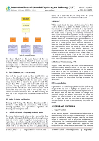
3. METHODOLOGY
For a system that can find potholes in real-time, the
suggested method looks for potholes with a custom-
trained YOLOv7 model, SVM machine learning algorithm,
and image segmentation. Like the other modules, YOLOv7
gets information from the webcam or live camera and
sends the pictures through the trained model. Each
picture is annotated after the dataset has been collected.
Before giving it to deep learning models like the YOLO
family to train custom models, the labeled data is split into
training and testing data.](https://image.slidesharecdn.com/irjet-v10i5304-230701102959-3c8bf82a/85/Pothole-Detection-Using-ML-and-DL-Algorithms-2-320.jpg)
![International Research Journal of Engineering and Technology (IRJET) e-ISSN: 2395-0056
Volume: 10 Issue: 05 | May 2023 www.irjet.net p-ISSN: 2395-0072
© 2023, IRJET | Impact Factor value: 8.226 | ISO 9001:2008 Certified Journal | Page 1620
This Project will help many peoples to detect Potholes in
the Future this Software can be implemented in the Car as
an in-build so the speed of detection will increase.
6. REFERENCES
[4] ”Detection of Potholes using Machine Learning and
Image Processing” 2017. Multimedia Tools and
Applications 78:37. Prof. Vijayalakshmi B, Kiran P, Kishor
Jadav B, Madhusudan G R, Manoj K S DOI:
10.17577/IJERTCONV8IS15039
[5] Desai, A. Soni, D. Panchal and S. Gajjar, ”Design,
Development and Testing of Automatic Pothole Detection
and Alert System,” 2019 IEEE 16th India Council
International Conference (INDICON), Rajkot, India, 2019,
pp. 1-4, DOI:
10.1109/INDICON47234.2019.9030271
[6] Nienaber, S. Booysen, MJ, and Kroon, RS, 2015.
Detecting potholes using simple image processing
techniques and real-world footage.
[7] Review of Recent Automated Pothole-Detection
Methods Young-Mok Kim 1, YoungGil Kim 1, Seung- Yong
Son 2, Soo-Yeon Lim 3, Bong-Yeol Choi 4 and Doo-Hyun
Choi
[8] Lee, S., Kim, S., An, K. E., Ryu, S.-K., Seo, D. (2018).
”Image processing-based pothole detecting system for the
driving environment” 2018 IEEE International Conference
on Consumer Electronics (ICCE). DOI:
10.1109/ICCE.2018.8326
[1] K Vigneshwar and B. H. Kumar, ”Detection and
counting of pothole using image processing techniques,
2016 IEEE International Conference on Computational
Intelligence and Computing Research (ICCIC), Chennai,
2016, pp. 1-4, DOI: 10.1109/ICCIC.2016.7919622
[2]”Smart Implementation of Computer Vision and
Machine Learning for Pothole Detection” 2021 11th
International Conference on Cloud Computing, Data
Science Engineering (Confluence) DOI:
10.1109/Confluence51648.2021.9376886
[3]”Pothole Detection Using Machine Learning
Algorithms”2021 15th International Conference on Signal
Processing and Communication Systems (ICSPCS) DOI:
10.1109/ICSPCS53099.2021.9660216](https://image.slidesharecdn.com/irjet-v10i5304-230701102959-3c8bf82a/85/Pothole-Detection-Using-ML-and-DL-Algorithms-6-320.jpg)

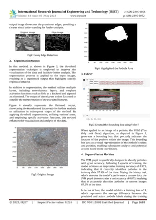
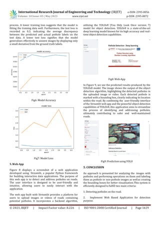
The document presents an integrated approach for pothole detection and classification using computer vision and machine learning techniques. Specifically, it uses YOLOv7 for object detection, SVM for classification, and image segmentation. A web application is also developed using Streamlit to provide an intuitive interface for users to upload images and view detection results. The methodology section describes data collection and preprocessing, model training and testing using YOLOv7 and SVM, pothole detection through these deep learning models, and image segmentation techniques. The results section shows outputs of edge detection, segmentation, bounding box detection through YOLOv7, and SVM classification accuracy. The proposed approach aims to help authorities identify problematic road areas efficiently.


![Final_Road_Classification_Pothole_Detection_PPT[1].pptx](https://cdn.slidesharecdn.com/ss_thumbnails/finalroadclassificationpotholedetectionppt1-260106175235-72ada4c8-thumbnail.jpg?width=640&height=640&fit=bounds)


![Pothole_Depth_Estimation_LiDAR_BGIET_ppt[1].pptx](https://cdn.slidesharecdn.com/ss_thumbnails/potholedepthestimationlidarbgietppt1-250928095107-b77307ea-thumbnail.jpg?width=640&height=640&fit=bounds)


