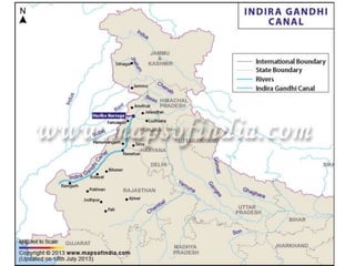
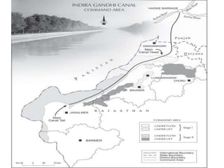
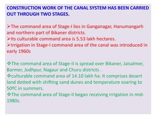
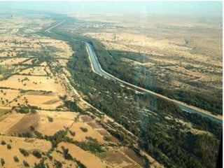
PLANNING AND SUSTAINABLE
DEVELOPMENT IN INDIAN CONTEXT
What is Planning?
IMPLEMENTATION OF A SET OF ACTIONS TO
ACHIEVE SOME GOAL
FORMULATION OF A SCHEME OR
PROGRAMME A
PROCESS OF THINKING
The sectoral planning means formulation and
implementation of the sets of schemes or programmes
aimed at development of various sectors of the economy
such as agriculture, irrigation, manufacturing, power,
construction, transport, communication, social
infrastructure and services.
There is no uniform economic development over space in
any country. Some areas are more developed and some
lag behind. This uneven pattern of development over
space necessitates that the planners have a spatial
perspective and draw the plans to reduce regional
imbalance in development. This type of planning is
termed as regional planning
Target Area Planning
The planning process has to take special care of those
areas which have remained economically backward.
The economic development of a region depends upon its
resource base. It also requires technology as well as
investment besides the resource.
It was realised that regional imbalances in economic
development were getting accentuated.
In order to arrest the accentuation of regional and social
disparties, the Planning Commission introduced the
‘target area’ and target group approaches to planning.
Examples of target area programme
Command Area Development Programme
Drought Prone Area Development Programme
Desert Development Programme
Hill Area Development Programme.
Examples of target group programme
The Small Farmers Development Agency (SFDA)
 Marginal Farmers Development Agency (MFDA
In the 8th Five year Plan special area programmes were
designed to develop infrastructure in hill areas, north-
eastern states, tribal areas and backward areas.
Hill Area Development Programme
Hill Area Development Programmes were initiated during Fifth Five
Year Plan covering 15 districts comprising all the hilly areas like
Uttranchal, Mikir Hill and North Cachar hills of Assam, Darjiling
district of West Bengal and Nilgiri district of Tamil Nadu.
The National Committee on the Development of Backward Area in
1981 recommended that all the hill areas in the country having
height above 600 m and not covered under tribal sub-plan be
treated as backward hill areas.
AIM: Harnessing the indigenous resources of the hill areas through
development of horticulture, plantation agriculture, animal
husbandry, poultry, forestry and small-scale and village industry.
Drought Prone Area Programme
( initiated during the Fourth Five Year Plan)
OBJECTIVES :
providing employment to the people in drought-
prone areas
creating productive assets.
It emphasised on irrigation projects, land
development programmes, afforestation, grassland
development and creation of basic rural
infrastructure such as electricity, roads, market,
credit and services.
STATERGIES:
To create alternative employment opportunities
in the drought prone areas.
Adoption of integrated watershed development
approach at the micro-level.
The restoration of ecological balance
Planning Commission of India (1967)
identified 67 districts (entire or partly) of the
country prone to drought.
Semi-arid and arid tract of Rajasthan,
Gujarat, Western Madhya Pradesh,
Marathwada region of Maharashtra,
Rayalseema and Telangana plateaus of
Andhra Pradesh, Karnataka plateau and
highlands and interior parts of Tamil Nadu.
The drought prone areas of Punjab, Haryana
and north-Rajasthan are largely protected
due to spread of irrigation in these regions
Integrated Tribal Development Project in
Bharmaur Region
Bharmaur tribal area comprises Bharmaur and Holi
tehsils of Chamba district of Himachal Pradesh.
It is a notified tribal area since 21 November 1975.
Bharmaur is inhabited by ‘Gaddi’, a tribal community
 Practise transhumance
Speak Gaddiali dialect.
Bharmaur tribal region has harsh climate conditions, low
resource base and fragile Environment.
According to the 2011 census, the total population of
Bharmaur sub-division was 39,113 i.e. 21 persons per sq
km.
 It is one of the most(economically and socially)
backward areas of Himachal Pradesh.
Historically, the Gaddis have experienced geographical
and political isolation and socio-economic deprivation.
The economy is largely based on agriculture and allied
activities such as sheep and goat rearing.
The process of development of tribal area of Bharmaur
started in 1970s when Gaddis were included among
‘scheduled tribes’.
Under the Fifth Five Year Plan, the tribal sub-plan was
introduced in 1974 and Bharmaur was designated as one
of the five Integrated Tribal Development Projects (ITDP)
in HimachalPradesh.
AIMS:
Improving the quality of life of the Gaddis
Narrowing the gap in the level of development between
Bharmaur and other areas of Himachal Pradesh.
ACTION/STEPS TAKEN
Highest priority on the development of transport
and communications, agriculture and allied
activities, and social and community services.
Development of infrastructure in terms of schools,
health care facilities, potable water, roads,
communications and electricity.
The remote villages in Tundah and Kugti areas still
do not have sufficient infrastructure.
RESULT
Tremendous increase in literacy rate
Improvement in sex ratio
Decline in child marriage.
The female literary rate in the region increased from 1.88 per
cent in 1971 to 65 per cent in 2011.
The difference between males and females in literacy level i.e.
gender inequality, has also declined.
Traditionally, the Gaddis had subsistence agricultural-cum-
pastoral economy having emphasis on foodgrains and livestock
production. But during the last three decades of the cultivation of
pulses and other cash crops has increased in Bharmaur region.
But the Gaddis are still very mobile as a sizeable section of them
migrate to Kangra and surrounding areas during winter to earn their
livings from wage labour.
SUSTAINABLE DEVELOPMENT
In the post World War II era, the concept of development
was synonymous to economic growth which is measured
in terms of temporal increase in gross national product
(GNP) and per capita income/per capita consumption.
in 1970s, the phrases such as redistribution with growth
and growth and equity were incorporated in the definition
of development. It was realised that the concept of
development cannot be restricted to the economic sphere
alone. It also includes the issues such as improving the
well-being and living standard of people, availing of the
health, education and equality of opportunity and
ensuring political and civil rights.
The notion of sustainable development emerged in the wake of general
rise in the awareness of environmental issues in the late 1960s in
Western World.
The publication of ‘The Population Bomb’ by Ehrlich in 1968 and ‘The
Limits to Growth’ by Meadows and others in 1972 further raised the
level of fear among environmentalists in particular and people in
general.
Concerned with the growing opinion of world community on the
environmental issues, the U N established a World Commission on
Environment and Development headed by the Norwegian Prime
Minister Gro Harlem Brundtland.
The Commission gave its report (Brundtland Report) entitled ‘Our
Common Future’ in 1987. It defines sustainable development as a
“development that meets the needs of the present without
compromising the ability of future generations to meet their own
needs.”
Indira Gandhi Canal (Nahar) Command Area : Measures
for Promotion of Sustainable Development
Indira Gandhi Canal, previously known as the Rajasthan Canal, is
one of the largest canal systems in India.
Conceived by Kanwar Sain in 1948, the canal project was launched
on 31 March, 1958.
The canal originates at Harike barrage in Punjab and runs parallel
to Pakistan border at an average distance of 40 km in Thar Desert
(Marusthali) of Rajasthan.
The total planned length of the system is 9,060 km catering to the
irrigation needs of a total culturable command area of 19.63 lakh
hectares.
Out of the total command area, about 70 per cent was envisaged
to be irrigated by flow system and the rest by lift system.
CONSTRUCTION WORK OF THE CANAL SYSTEM HAS BEEN CARRIED
OUT THROUGH TWO STAGES.
The command area of Stage-I lies in Ganganagar, Hanumangarh
and northern part of Bikaner districts.
Its culturable command area is 5.53 lakh hectares.
Irrigation in Stage-I command area of the canal was introduced in
early 1960s
The command area of Stage-II is spread over Bikaner, Jaisalmer,
Barmer, Jodhpur, Nagaur and Churu districts .
culturable command area of 14.10 lakh ha. It comprises desert
land dotted with shifting sand dunes and temperature soaring to
50ºC in summers.
The command area of Stage-II began receiving irrigation in mid-
1980s.
POSITIVE EFFECTS
I. The availability of soil moisture for a longer period of
time and various afforestation and pasture
development programmes under CAD have resulted in
greening the land.
II. Helped in reducing wind erosion .
III. Reduced siltation of canal systems.
IV. Spread of canal irrigation has led to increase in
cultivated area and intensity of cropping.
V. The traditional crops sown in the area, gram, bajra and
jowar have been replaced by wheat, cotton,
groundnut and rice.
NEGATIVE EFFECTS
But the intensive irrigation and excessive use
of water has led to the emergence of twin
environmental problems of water logging
Increase in soil salinity.
Measures for Promotion of Sustainable Development
(i)The first requirement is strict implementation of water
management policy. The canal project envisages protective irrigation
in Stage-I and extensive irrigation of crops and pasture development
in Stage-II.
(ii) In general, the cropping pattern shall not include water intensive
crops.
(iii) The CAD programmes such as lining of water courses, land
development and levelling and warabandi system (equal distribution
of canal water in the command area of outlet) shall be effectively
implemented to reduce the conveyance loss of water.
(i
(iv) The areas affected by water logging and soil salinity shall be
reclaimed.
(v) The eco-development through afforestation, shelterbelt
plantation and pasture development is necessary particularly in the
fragile environment of Stage-II.
(vi) The social sustainability in the region can be achieved only if the
land allottees having poor economic background are provided
adequate financial and institutional support for cultivation of land.
(vii) The economic sustainability in the region cannot be attained
only through development of agriculture and animal husbandry. The
agricultural and allied activities have to develop along with other
sectors of economy. This shall lead to diversification of economic
base and establishment of functional linkages between basic
villages, agro-service centres and market centres.

Planning and sustainable development in indian context

  • 1.
  • 2.
  • 3.
    IMPLEMENTATION OF ASET OF ACTIONS TO ACHIEVE SOME GOAL FORMULATION OF A SCHEME OR PROGRAMME A PROCESS OF THINKING
  • 4.
    The sectoral planningmeans formulation and implementation of the sets of schemes or programmes aimed at development of various sectors of the economy such as agriculture, irrigation, manufacturing, power, construction, transport, communication, social infrastructure and services. There is no uniform economic development over space in any country. Some areas are more developed and some lag behind. This uneven pattern of development over space necessitates that the planners have a spatial perspective and draw the plans to reduce regional imbalance in development. This type of planning is termed as regional planning
  • 5.
    Target Area Planning Theplanning process has to take special care of those areas which have remained economically backward. The economic development of a region depends upon its resource base. It also requires technology as well as investment besides the resource. It was realised that regional imbalances in economic development were getting accentuated. In order to arrest the accentuation of regional and social disparties, the Planning Commission introduced the ‘target area’ and target group approaches to planning.
  • 6.
    Examples of targetarea programme Command Area Development Programme Drought Prone Area Development Programme Desert Development Programme Hill Area Development Programme. Examples of target group programme The Small Farmers Development Agency (SFDA)  Marginal Farmers Development Agency (MFDA In the 8th Five year Plan special area programmes were designed to develop infrastructure in hill areas, north- eastern states, tribal areas and backward areas.
  • 7.
    Hill Area DevelopmentProgramme Hill Area Development Programmes were initiated during Fifth Five Year Plan covering 15 districts comprising all the hilly areas like Uttranchal, Mikir Hill and North Cachar hills of Assam, Darjiling district of West Bengal and Nilgiri district of Tamil Nadu. The National Committee on the Development of Backward Area in 1981 recommended that all the hill areas in the country having height above 600 m and not covered under tribal sub-plan be treated as backward hill areas. AIM: Harnessing the indigenous resources of the hill areas through development of horticulture, plantation agriculture, animal husbandry, poultry, forestry and small-scale and village industry.
  • 8.
    Drought Prone AreaProgramme ( initiated during the Fourth Five Year Plan) OBJECTIVES : providing employment to the people in drought- prone areas creating productive assets. It emphasised on irrigation projects, land development programmes, afforestation, grassland development and creation of basic rural infrastructure such as electricity, roads, market, credit and services.
  • 9.
    STATERGIES: To create alternativeemployment opportunities in the drought prone areas. Adoption of integrated watershed development approach at the micro-level. The restoration of ecological balance Planning Commission of India (1967) identified 67 districts (entire or partly) of the country prone to drought.
  • 10.
    Semi-arid and aridtract of Rajasthan, Gujarat, Western Madhya Pradesh, Marathwada region of Maharashtra, Rayalseema and Telangana plateaus of Andhra Pradesh, Karnataka plateau and highlands and interior parts of Tamil Nadu. The drought prone areas of Punjab, Haryana and north-Rajasthan are largely protected due to spread of irrigation in these regions
  • 11.
    Integrated Tribal DevelopmentProject in Bharmaur Region Bharmaur tribal area comprises Bharmaur and Holi tehsils of Chamba district of Himachal Pradesh. It is a notified tribal area since 21 November 1975. Bharmaur is inhabited by ‘Gaddi’, a tribal community  Practise transhumance Speak Gaddiali dialect.
  • 13.
    Bharmaur tribal regionhas harsh climate conditions, low resource base and fragile Environment. According to the 2011 census, the total population of Bharmaur sub-division was 39,113 i.e. 21 persons per sq km.  It is one of the most(economically and socially) backward areas of Himachal Pradesh. Historically, the Gaddis have experienced geographical and political isolation and socio-economic deprivation. The economy is largely based on agriculture and allied activities such as sheep and goat rearing.
  • 14.
    The process ofdevelopment of tribal area of Bharmaur started in 1970s when Gaddis were included among ‘scheduled tribes’. Under the Fifth Five Year Plan, the tribal sub-plan was introduced in 1974 and Bharmaur was designated as one of the five Integrated Tribal Development Projects (ITDP) in HimachalPradesh. AIMS: Improving the quality of life of the Gaddis Narrowing the gap in the level of development between Bharmaur and other areas of Himachal Pradesh.
  • 15.
    ACTION/STEPS TAKEN Highest priorityon the development of transport and communications, agriculture and allied activities, and social and community services. Development of infrastructure in terms of schools, health care facilities, potable water, roads, communications and electricity. The remote villages in Tundah and Kugti areas still do not have sufficient infrastructure.
  • 16.
    RESULT Tremendous increase inliteracy rate Improvement in sex ratio Decline in child marriage. The female literary rate in the region increased from 1.88 per cent in 1971 to 65 per cent in 2011. The difference between males and females in literacy level i.e. gender inequality, has also declined. Traditionally, the Gaddis had subsistence agricultural-cum- pastoral economy having emphasis on foodgrains and livestock production. But during the last three decades of the cultivation of pulses and other cash crops has increased in Bharmaur region. But the Gaddis are still very mobile as a sizeable section of them migrate to Kangra and surrounding areas during winter to earn their livings from wage labour.
  • 17.
    SUSTAINABLE DEVELOPMENT In thepost World War II era, the concept of development was synonymous to economic growth which is measured in terms of temporal increase in gross national product (GNP) and per capita income/per capita consumption. in 1970s, the phrases such as redistribution with growth and growth and equity were incorporated in the definition of development. It was realised that the concept of development cannot be restricted to the economic sphere alone. It also includes the issues such as improving the well-being and living standard of people, availing of the health, education and equality of opportunity and ensuring political and civil rights.
  • 18.
    The notion ofsustainable development emerged in the wake of general rise in the awareness of environmental issues in the late 1960s in Western World. The publication of ‘The Population Bomb’ by Ehrlich in 1968 and ‘The Limits to Growth’ by Meadows and others in 1972 further raised the level of fear among environmentalists in particular and people in general. Concerned with the growing opinion of world community on the environmental issues, the U N established a World Commission on Environment and Development headed by the Norwegian Prime Minister Gro Harlem Brundtland. The Commission gave its report (Brundtland Report) entitled ‘Our Common Future’ in 1987. It defines sustainable development as a “development that meets the needs of the present without compromising the ability of future generations to meet their own needs.”
  • 19.
    Indira Gandhi Canal(Nahar) Command Area : Measures for Promotion of Sustainable Development Indira Gandhi Canal, previously known as the Rajasthan Canal, is one of the largest canal systems in India. Conceived by Kanwar Sain in 1948, the canal project was launched on 31 March, 1958. The canal originates at Harike barrage in Punjab and runs parallel to Pakistan border at an average distance of 40 km in Thar Desert (Marusthali) of Rajasthan. The total planned length of the system is 9,060 km catering to the irrigation needs of a total culturable command area of 19.63 lakh hectares. Out of the total command area, about 70 per cent was envisaged to be irrigated by flow system and the rest by lift system.
  • 22.
    CONSTRUCTION WORK OFTHE CANAL SYSTEM HAS BEEN CARRIED OUT THROUGH TWO STAGES. The command area of Stage-I lies in Ganganagar, Hanumangarh and northern part of Bikaner districts. Its culturable command area is 5.53 lakh hectares. Irrigation in Stage-I command area of the canal was introduced in early 1960s The command area of Stage-II is spread over Bikaner, Jaisalmer, Barmer, Jodhpur, Nagaur and Churu districts . culturable command area of 14.10 lakh ha. It comprises desert land dotted with shifting sand dunes and temperature soaring to 50ºC in summers. The command area of Stage-II began receiving irrigation in mid- 1980s.
  • 23.
    POSITIVE EFFECTS I. Theavailability of soil moisture for a longer period of time and various afforestation and pasture development programmes under CAD have resulted in greening the land. II. Helped in reducing wind erosion . III. Reduced siltation of canal systems. IV. Spread of canal irrigation has led to increase in cultivated area and intensity of cropping. V. The traditional crops sown in the area, gram, bajra and jowar have been replaced by wheat, cotton, groundnut and rice.
  • 25.
    NEGATIVE EFFECTS But theintensive irrigation and excessive use of water has led to the emergence of twin environmental problems of water logging Increase in soil salinity.
  • 26.
    Measures for Promotionof Sustainable Development (i)The first requirement is strict implementation of water management policy. The canal project envisages protective irrigation in Stage-I and extensive irrigation of crops and pasture development in Stage-II. (ii) In general, the cropping pattern shall not include water intensive crops. (iii) The CAD programmes such as lining of water courses, land development and levelling and warabandi system (equal distribution of canal water in the command area of outlet) shall be effectively implemented to reduce the conveyance loss of water. (i
  • 27.
    (iv) The areasaffected by water logging and soil salinity shall be reclaimed. (v) The eco-development through afforestation, shelterbelt plantation and pasture development is necessary particularly in the fragile environment of Stage-II. (vi) The social sustainability in the region can be achieved only if the land allottees having poor economic background are provided adequate financial and institutional support for cultivation of land. (vii) The economic sustainability in the region cannot be attained only through development of agriculture and animal husbandry. The agricultural and allied activities have to develop along with other sectors of economy. This shall lead to diversification of economic base and establishment of functional linkages between basic villages, agro-service centres and market centres.