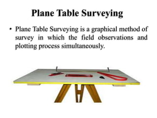
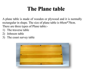
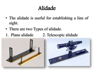
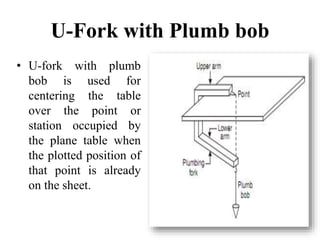
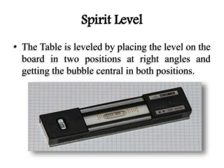
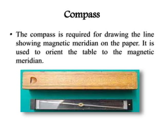
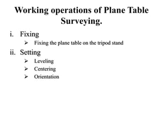
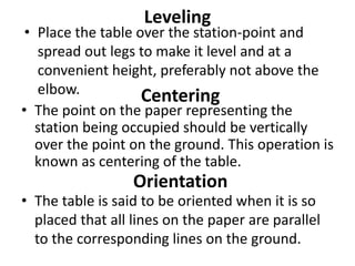
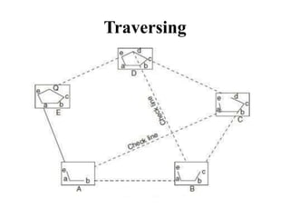
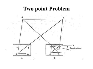
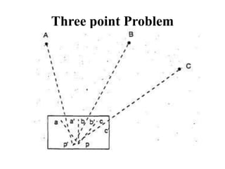
DR. K. N. MODI UNIVERSITY
Newai, Rajasthan
DEPARTMENT OF CIVIL
ENGINEERING
Created By:-
Bimlesh Thakur
Content
• Introduction of plane Table Surveying.
• Equipment Used in Plane Table Surveying.
• Working operations of Plane Table Surveying.
• Method of Plane Table Surveying.
• Two point Problem.
• Three point Problem.
Plane Table Surveying
• Plane Table Surveying is a graphical method of
survey in which the field observations and
plotting process simultaneously.
Equipments Used in Plane Table
Surveying.
The plane table
Alidade
U-Fork with Plumb bob
Spirit Level
Compass
Drawing Paper
The Plane table
A plane table is made of wooden or plywood and it is normally
rectangular in shape. The size of plane table is 60cm*70cm.
There are three types of Plane table:-
1) The traverse table
2) Johnson table
3) The coast survey table
Tripod
• The plane table is mounted on a tripod
• Tripod is provided with three foot screws at its
top for leveling of the plane table.
Alidade
• The alidade is useful for establishing a line of
sight.
• There are two Types of alidade.
1. Plane alidade 2. Telescopic alidade
U-Fork with Plumb bob
• U-fork with plumb
bob is used for
centering the table
over the point or
station occupied by
the plane table when
the plotted position of
that point is already
on the sheet.
Spirit Level
• The Table is leveled by placing the level on the
board in two positions at right angles and
getting the bubble central in both positions.
Compass
• The compass is required for drawing the line
showing magnetic meridian on the paper. It is
used to orient the table to the magnetic
meridian.
Drawing Paper
• Drawing paper is used for plotting the ground
details.
Working operations of Plane Table
Surveying.
i. Fixing
 Fixing the plane table on the tripod stand
ii. Setting
 Leveling
 Centering
 Orientation
Leveling
• Place the table over the station-point and
spread out legs to make it level and at a
convenient height, preferably not above the
elbow. Centering
• The point on the paper representing the
station being occupied should be vertically
over the point on the ground. This operation is
known as centering of the table.
Orientation
• The table is said to be oriented when it is so
placed that all lines on the paper are parallel
to the corresponding lines on the ground.
Methods Of Plane Tabling
1. Radiation
2. Intersection
3. Traversing
4. Resection
I. Compass Method
II. Back-ray Method
III. Two-point problem
IV. Three-point problem
Radiation
Intersection
Traversing
Two point Problem
Three point Problem
THANK YOU

Plane table surveying

  • 1.
    DR. K. N.MODI UNIVERSITY Newai, Rajasthan DEPARTMENT OF CIVIL ENGINEERING Created By:- Bimlesh Thakur
  • 2.
    Content • Introduction ofplane Table Surveying. • Equipment Used in Plane Table Surveying. • Working operations of Plane Table Surveying. • Method of Plane Table Surveying. • Two point Problem. • Three point Problem.
  • 3.
    Plane Table Surveying •Plane Table Surveying is a graphical method of survey in which the field observations and plotting process simultaneously.
  • 4.
    Equipments Used inPlane Table Surveying. The plane table Alidade U-Fork with Plumb bob Spirit Level Compass Drawing Paper
  • 5.
    The Plane table Aplane table is made of wooden or plywood and it is normally rectangular in shape. The size of plane table is 60cm*70cm. There are three types of Plane table:- 1) The traverse table 2) Johnson table 3) The coast survey table
  • 6.
    Tripod • The planetable is mounted on a tripod • Tripod is provided with three foot screws at its top for leveling of the plane table.
  • 7.
    Alidade • The alidadeis useful for establishing a line of sight. • There are two Types of alidade. 1. Plane alidade 2. Telescopic alidade
  • 8.
    U-Fork with Plumbbob • U-fork with plumb bob is used for centering the table over the point or station occupied by the plane table when the plotted position of that point is already on the sheet.
  • 9.
    Spirit Level • TheTable is leveled by placing the level on the board in two positions at right angles and getting the bubble central in both positions.
  • 10.
    Compass • The compassis required for drawing the line showing magnetic meridian on the paper. It is used to orient the table to the magnetic meridian.
  • 11.
    Drawing Paper • Drawingpaper is used for plotting the ground details.
  • 12.
    Working operations ofPlane Table Surveying. i. Fixing  Fixing the plane table on the tripod stand ii. Setting  Leveling  Centering  Orientation
  • 13.
    Leveling • Place thetable over the station-point and spread out legs to make it level and at a convenient height, preferably not above the elbow. Centering • The point on the paper representing the station being occupied should be vertically over the point on the ground. This operation is known as centering of the table. Orientation • The table is said to be oriented when it is so placed that all lines on the paper are parallel to the corresponding lines on the ground.
  • 14.
    Methods Of PlaneTabling 1. Radiation 2. Intersection 3. Traversing 4. Resection I. Compass Method II. Back-ray Method III. Two-point problem IV. Three-point problem
  • 15.
  • 16.
  • 17.
  • 18.
  • 19.
  • 20.