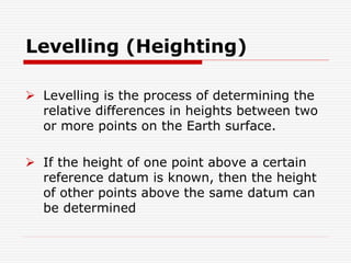
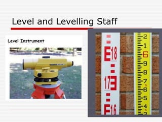
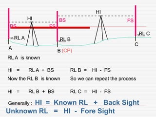
Levelling, also known as heighting, is the process of determining relative height differences between points on the Earth's surface. If the height of one point is known relative to a datum, then the heights of other points can be found relative to the same datum. This is done using a leveling instrument, leveling staff, and following standard procedures such as taking backsight and foresight readings. Care must be taken to eliminate errors from things like atmospheric refraction. Results are typically recorded in a level book or form and can be reduced using methods like height of instrument or rise and fall.
Metric Chain : It Consists of galvanized mild steel wire of 4mm diameter known as link.
It is available in 20m, 30m, 50m length which consists of 100 links.
Gunter’s Chain : A 66 feet long chain consists of 100 links, each of 0.66 feet, it is known as Gunter’s chain.
This chain is suitable for taking length in miles.
Engineer’s Chain : A 100 feet long chain consisting of 100 links each of 1 feet is known as engineer’s chain.
This chain is used to measure length in feet and area in sq.yard.
Revenue Chain : it is 33 feet long chain consisting of 16 links.
This chain is used for distance measurements in feet & inches for smaller areas.
surveying Engineering
Fly Levelling
Fly leveling: -Fly leveling is just like differential leveling carried
out to check the accuracy of leveling work. It is a very approximate
form of leveling in which sights are taken as large as possible. in this
method, a line of levels is run to determine approximately reduced
levels of the points carried out with more rapidly and less precision
The aim of fly Levelling: The main purpose of this type of leveling is
to check the values of the reduced levels of the bench marks already
fixed. In this method only back sight and foresight are taken. There is no need of intermediate sights. However great care has to be taken for selecting the change points (Turning Points) and for taking reading on the change points because the accuracy of leveling depends upon these
-Create Bench Marks (BM).
Bench Marks
Bench Mark is a point of known elevation, there are three Type of Bench Marks
1-Perment Bench Mark.
2-Orbitrary Bench Mark .
3-Temporary Bench Mark .
-Leveling Process Calculation.
1. Height of collimation method
2. Rise and Fall method
How do we find horizontal distance using levelling Machine.
Fly Levelling Close loop survey.
Fly and Differential leveling Using (Rise & fall) and (HI)methods.
*Checks for Errors
-Misclosure
Allowable closing error
Where:
D =Distance in km
E = Misclosure error in (mm).
C = 30 for fixed levelling process in rough ground.
C = 15 for normal leveling in flat area (Good work)
Fly Levelling example
Computation of Elevations for an open loop survey H.I method
Computation of Elevations
Differential Leveling
Computation of Elevations
-Correction For Errors in Leveling
1. Errors Due to the line of sight being not horizontal
2. Error Due to Curvature and refraction.
Errors in differential leveling: -
1) Non adjustment of the instrument: -
a) Adjustment of cross-wire ring
b) Adjustment of the bubble tube
c) Adjustment of line of sight
2-Errors in levelling
• Collimation line
• Parallax
• Change point instability
• Instrument instability
• Benchmark instability
• Staff reading errors , • Staff verticality • Level Instrument shading • Temperature on staff • Booking errors) • Earth curvature • Refraction • The Bubble not center.
3-Constant error (instrumental error):
A. Non vertically of the staff.
B. Collimation error in the instrument.
C. Staff gradation error.
4- Random error (natural error):
A. Effect of wind and temperature.
B. Soft and hard ground.
C. Change points. CP
D. Human deficiencies and neglect
Prepared by:
Asst. Prof. Salar K.Hussein
Mr. Kamal Y.Abdullah
Asst.Lecturer. Dilveen H. Omar
Erbil Polytechnic University
Technical Engineering College
Civil Engineering Department
Introduction to surveying, ranging and chainingShital Navghare
This presentation contains the complete introduction of surveying. It also includes all the instrucments used in linear measurement and the terms related to Ranging and Chaining
Surveying is an important part of Civil engineering. Various part like theodolite, plane table surveying, computation of area and volume are useful for all university examination and other competitive examination
Introduction, classification of curves, Elements of a simple circular, designation of curve, methods of setting out a simple circular curve, elements of a compound and reverse curves, transition curve, types of transition curves, combined curve, types of vertical curves
Introduction, purpose, principle, instruments, methods of tacheometry, stadia constants, anallatic lens, Subtense bar, field work in tacheometry, reduction of readings, errors and precisions.
Levelling in surveying is the process of determining the height of one level relative to another. It is used to establish the elevation of a point relative to a datum, or to establish a point at a given elevation relative to a datum
Welcome to WIPAC Monthly the magazine brought to you by the LinkedIn Group Water Industry Process Automation & Control.
In this month's edition, along with this month's industry news to celebrate the 13 years since the group was created we have articles including
A case study of the used of Advanced Process Control at the Wastewater Treatment works at Lleida in Spain
A look back on an article on smart wastewater networks in order to see how the industry has measured up in the interim around the adoption of Digital Transformation in the Water Industry.
An Approach to Detecting Writing Styles Based on Clustering Techniquesambekarshweta25
An Approach to Detecting Writing Styles Based on Clustering Techniques
Authors:
-Devkinandan Jagtap
-Shweta Ambekar
-Harshit Singh
-Nakul Sharma (Assistant Professor)
Institution:
VIIT Pune, India
Abstract:
This paper proposes a system to differentiate between human-generated and AI-generated texts using stylometric analysis. The system analyzes text files and classifies writing styles by employing various clustering algorithms, such as k-means, k-means++, hierarchical, and DBSCAN. The effectiveness of these algorithms is measured using silhouette scores. The system successfully identifies distinct writing styles within documents, demonstrating its potential for plagiarism detection.
Introduction:
Stylometry, the study of linguistic and structural features in texts, is used for tasks like plagiarism detection, genre separation, and author verification. This paper leverages stylometric analysis to identify different writing styles and improve plagiarism detection methods.
Methodology:
The system includes data collection, preprocessing, feature extraction, dimensional reduction, machine learning models for clustering, and performance comparison using silhouette scores. Feature extraction focuses on lexical features, vocabulary richness, and readability scores. The study uses a small dataset of texts from various authors and employs algorithms like k-means, k-means++, hierarchical clustering, and DBSCAN for clustering.
Results:
Experiments show that the system effectively identifies writing styles, with silhouette scores indicating reasonable to strong clustering when k=2. As the number of clusters increases, the silhouette scores decrease, indicating a drop in accuracy. K-means and k-means++ perform similarly, while hierarchical clustering is less optimized.
Conclusion and Future Work:
The system works well for distinguishing writing styles with two clusters but becomes less accurate as the number of clusters increases. Future research could focus on adding more parameters and optimizing the methodology to improve accuracy with higher cluster values. This system can enhance existing plagiarism detection tools, especially in academic settings.
6th International Conference on Machine Learning & Applications (CMLA 2024)ClaraZara1
6th International Conference on Machine Learning & Applications (CMLA 2024) will provide an excellent international forum for sharing knowledge and results in theory, methodology and applications of on Machine Learning & Applications.
Student information management system project report ii.pdfKamal Acharya
Our project explains about the student management. This project mainly explains the various actions related to student details. This project shows some ease in adding, editing and deleting the student details. It also provides a less time consuming process for viewing, adding, editing and deleting the marks of the students.
Industrial Training at Shahjalal Fertilizer Company Limited (SFCL)MdTanvirMahtab2
This presentation is about the working procedure of Shahjalal Fertilizer Company Limited (SFCL). A Govt. owned Company of Bangladesh Chemical Industries Corporation under Ministry of Industries.
Final project report on grocery store management system..pdfKamal Acharya
In today’s fast-changing business environment, it’s extremely important to be able to respond to client needs in the most effective and timely manner. If your customers wish to see your business online and have instant access to your products or services.
Online Grocery Store is an e-commerce website, which retails various grocery products. This project allows viewing various products available enables registered users to purchase desired products instantly using Paytm, UPI payment processor (Instant Pay) and also can place order by using Cash on Delivery (Pay Later) option. This project provides an easy access to Administrators and Managers to view orders placed using Pay Later and Instant Pay options.
In order to develop an e-commerce website, a number of Technologies must be studied and understood. These include multi-tiered architecture, server and client-side scripting techniques, implementation technologies, programming language (such as PHP, HTML, CSS, JavaScript) and MySQL relational databases. This is a project with the objective to develop a basic website where a consumer is provided with a shopping cart website and also to know about the technologies used to develop such a website.
This document will discuss each of the underlying technologies to create and implement an e- commerce website.
Forklift Classes Overview by Intella PartsIntella Parts
Discover the different forklift classes and their specific applications. Learn how to choose the right forklift for your needs to ensure safety, efficiency, and compliance in your operations.
For more technical information, visit our website https://intellaparts.com
NO1 Uk best vashikaran specialist in delhi vashikaran baba near me online vas...Amil Baba Dawood bangali
Contact with Dawood Bhai Just call on +92322-6382012 and we'll help you. We'll solve all your problems within 12 to 24 hours and with 101% guarantee and with astrology systematic. If you want to take any personal or professional advice then also you can call us on +92322-6382012 , ONLINE LOVE PROBLEM & Other all types of Daily Life Problem's.Then CALL or WHATSAPP us on +92322-6382012 and Get all these problems solutions here by Amil Baba DAWOOD BANGALI
#vashikaranspecialist #astrologer #palmistry #amliyaat #taweez #manpasandshadi #horoscope #spiritual #lovelife #lovespell #marriagespell#aamilbabainpakistan #amilbabainkarachi #powerfullblackmagicspell #kalajadumantarspecialist #realamilbaba #AmilbabainPakistan #astrologerincanada #astrologerindubai #lovespellsmaster #kalajaduspecialist #lovespellsthatwork #aamilbabainlahore#blackmagicformarriage #aamilbaba #kalajadu #kalailam #taweez #wazifaexpert #jadumantar #vashikaranspecialist #astrologer #palmistry #amliyaat #taweez #manpasandshadi #horoscope #spiritual #lovelife #lovespell #marriagespell#aamilbabainpakistan #amilbabainkarachi #powerfullblackmagicspell #kalajadumantarspecialist #realamilbaba #AmilbabainPakistan #astrologerincanada #astrologerindubai #lovespellsmaster #kalajaduspecialist #lovespellsthatwork #aamilbabainlahore #blackmagicforlove #blackmagicformarriage #aamilbaba #kalajadu #kalailam #taweez #wazifaexpert #jadumantar #vashikaranspecialist #astrologer #palmistry #amliyaat #taweez #manpasandshadi #horoscope #spiritual #lovelife #lovespell #marriagespell#aamilbabainpakistan #amilbabainkarachi #powerfullblackmagicspell #kalajadumantarspecialist #realamilbaba #AmilbabainPakistan #astrologerincanada #astrologerindubai #lovespellsmaster #kalajaduspecialist #lovespellsthatwork #aamilbabainlahore #Amilbabainuk #amilbabainspain #amilbabaindubai #Amilbabainnorway #amilbabainkrachi #amilbabainlahore #amilbabaingujranwalan #amilbabainislamabad
Understanding Inductive Bias in Machine LearningSUTEJAS
This presentation explores the concept of inductive bias in machine learning. It explains how algorithms come with built-in assumptions and preferences that guide the learning process. You'll learn about the different types of inductive bias and how they can impact the performance and generalizability of machine learning models.
The presentation also covers the positive and negative aspects of inductive bias, along with strategies for mitigating potential drawbacks. We'll explore examples of how bias manifests in algorithms like neural networks and decision trees.
By understanding inductive bias, you can gain valuable insights into how machine learning models work and make informed decisions when building and deploying them.
HEAP SORT ILLUSTRATED WITH HEAPIFY, BUILD HEAP FOR DYNAMIC ARRAYS.
Heap sort is a comparison-based sorting technique based on Binary Heap data structure. It is similar to the selection sort where we first find the minimum element and place the minimum element at the beginning. Repeat the same process for the remaining elements.
KuberTENes Birthday Bash Guadalajara - K8sGPT first impressionsVictor Morales
K8sGPT is a tool that analyzes and diagnoses Kubernetes clusters. This presentation was used to share the requirements and dependencies to deploy K8sGPT in a local environment.
We have compiled the most important slides from each speaker's presentation. This year’s compilation, available for free, captures the key insights and contributions shared during the DfMAy 2024 conference.
1. Levelling (Heighting)
Levelling is the process of determining the
relative differences in heights between two
or more points on the Earth surface.
If the height of one point above a certain
reference datum is known, then the height
of other points above the same datum can
be determined
3. Determination of height differences
ABH
ABH
(B.M) A
B
HA
HB
= HB – HA - Height differences
HB = HA +
MSL
ABH
4. Used terms
Mean Sea Level (MSL)/Datum
arbitrary surface to which the observed
height of points may be referred.
Bench Mark (B.M)
A point of known Reduced Level (R.L.).
Usually a permanent stable reference
point.
5. used terms
Vertical line
Direction defined by a plumb line under a pull of gravity OR
The direction followed by a freely falling object
A level surface (line)
This is a surface such that the direction of gravity is
perpendicular to it at all points. Hence it follows the earth
surface curvature
A horizontal surface (line)
This will form a tangent to the level surface and
perpendicular to a vertical line at one point.
Line of Collimation
This is the line of sight defined by the optical centre of the
objective lens and the centre of the cross-hair
6.
7. Definitions
Back sight (BS)
The first reading taken by an observer
at every instrument station.
Foresight (FS)
The last reading taken at an instrument
station
9. TYPE OF LEVELLING
Trigonometric levelling
Barometric levelling
Hydrostatic levelling
Spirit levelling
10. Equipments used in Levelling
A LEVEL: A device that can give us a
truly horizontal line
11. Equipments used in Levelling
A LEVELLING STAFF: A suitable
graduated staff for taking vertical
reading:
12. Level
There are three types of levels:
dumpy levels
tilting levels
automatic levels
‘The differences between the three types being in the
way in which the instruments are designed to be
adjusted to give a horizontal line’
13. Classes of Level
Levels normally fall into one of three classes.
Precise
Very accurate instruments for geodetic or any other very precise levelling.
It should be possible to level such an instrument to within +0.1mm.
Medium Accuracy
These are used for engineering surveys. They may be tilting or
automatic instruments capable of being levelled within the range
of 1 – 5mm.
Builders
Low accuracy, short range levelling such as setting out on building sites.
The results obtained with this class of instruments will be well within the
tolerances required on the majority of construction sites. (10mm)
14. Features of conventional level
consists of the followings;
1) Surveying telescope
2) Bubble tube
3) A body to hold the two together plus other
attachment. E.g. tribrach
16. A surveying optical telescope
eyepiece
object lensobject lensfocusing lensfocusing lens
diaphragm
Typical diaphragms - in different makes of instrument
cross hairs
focusing screw
Focusing
1. Rotate eyepiece to give a sharp,
clear image of the cross hairs
2. Rotate focusing screw to give a
sharp, clear image of the object
being observed.
The aim of focusing is to remove (eliminate) PARALLAX
line of
collimation
19. Surveying telescope
Eyepiece lens:
The magnifying eyepiece facilitates the
viewing of the diaphragm and the image
produced by the objective lens
20. Surveying telescope
Focusing lens:
A concave lens which can be moved inside the
telescope by turning the focusing screws
It alters the focal length of the objective lens
and therefore the position of the image
21. Parallax
When focussing any optical instrument it is vitally important
that we eliminate Parallax.
Move the eye up and down (or from left to right) over the
eyepiece of the telescope.
If the cross hairs move relative to the object being observed
then Parallax exists and the focussing is not satisfactory.
Parallax. Is the relative motion between cross-hairs and the
image
22. Bubble tube
Used for levelling the telescope i.e. making the line of
collimation to be horizontal
Two types of bubble exists;
Tubular bubble
Circular bubble
23. Bubble tube
Tubular bubble
The most accurate one and is formed by
taking an arc of circular tube and filling it
with a fluid. E.g. methyl alcohol
Circular bubble
Is less accurate than tubular bubble
Used for rough levelling up of instrument
and also ensuring the verticality of levelling
staff
24. The levelling Staff
Nothing than a big ruler
Used to measure vertical distance
Staff should be truly vertical
Graduated such that is possible to read them from over a
long distance.
The smallest distance graduated on staves is a cm and the
mm are estimated
25. Reading an E-type levelling staff
Read value at
the
horizontal
cross hair
The value is ?
1.900
1.910
1.920
1.9301.932
26. Step 1 Staff Slowly Leant
Towards Instrument
Important Note – The person
using the instrument keeps the
staff vertical by use of the
Vertical line in the instrument.
Step 2 Staff Slowly
Tilted away from
Instrument. When
Vertical lowest reading
will be reading recorded
Step 3 Staff Slowly Tilted
away from instrument. Once
past vertical readings will
increase
Removing Staff Reading Errors
28. Rise and Fall method
RL A RL B
A
B
BS FS ABH = BS - FS
Suppose,
If BS > FS, This implies a rise of slope
Suppose,
If BS < FS, This implies there is a fall of slope
consider two points A and B
29. Rise and Fall method
ABH
ABH
RL A RL B
A
B
BS FS = BS - FS
assuming that, RL A is known,
Then, level at B = Level at A - + Fall/Rise
RL B = RL A +
RL B = RL A - ABH
ABH
30. The Height of Instrument (HI)
Method
Line of collimation above the datum is found by
adding the staff reading on a point of known
level
HI = Known RL + Back Sight
31. RL A RL B
A
B
C
RL C
BS FS
BS FS
RL A is known
HI =
HI
RL A + BS RL B = HI - FS
(CP)
Now the RL B is known So we can repeat the process
HI =
HI
RL B + BS RL C = HI - FS
Generally : HI = Known RL + Back Sight
Unknown RL = HI - Fore Sight
32. General Procedures in Levelling
Consider two distances far apart, AB
How do you do?
Establish change points on the
Line
BS FS
A
B
33. General procedures in levelling
Horizontal line generated is more commonly
restricted in slope sites
We can only measure two points that are below
the line of sight
To measure height of point above the line of
sight, the instrument has to be moved to
another point or station
34. General procedures in levelling
Moving the instrument to another
station
RL A RL B
A
B
C
RL C
BS FS
BS FS
35. General procedures in levelling
Movement of the instrument have to be recorded
properly so that when the reduced level (RL) are
calculated they all refer to the same datum.
This method of levelling is called series levelling.
The intermediate staff points are called change point
The intermediate instrument station are called
instrument points
36. Summary of Levelling Procedure
When the level has been set up we always start with a BS to
a point whose RL is known
- such as an BM
The last reading at any instrument position is always a FS
Either the instrument moves or the staff moves -
never move both
We must always finish levelling at a point of known RL value
- such as an BM
always close your levelling
37. Procedural Rules
Always commence and finish a level run on
a Benchmark (B.M. or T.B.M.). The
Benchmark at the start may be different
than that at the finish.
The length of foresight and backsight
should be as equal as is practical.
The length of the lines of sight should be
kept less than 50m and more
conventionally 25m.
38. Procedural Rules
Staff readings of less than 0.5m should be
avoided to prevent errors due to
atmospheric refraction.
Change points should be located on suitable
ground, for example the top of a pointed
rock, or a nail placed in a footpath or road.
39. Booking of Levelling Observation
Readings observed are booked in a level
book/form
Reduction of these readings is carried
out in the same book/form
The two methods are:
Rise and Fall
Height of Instrument
40. The Height of Instrument Method
of Booking
The procedure is as follows;
BM
B
E
2.20
A
C
D
1.05
2.30 1.15
0.75
2.50
1.00
X
Y
Z
41. Note
The First entry is the RL of the BM which is
60.50m
The 2nd entry is the reading of the staff placed
on BM, booked under column of BS.
To get the HI, we add the RL of the BM to the
observed BS.
The staff is moved to A, which is an IS, and
read as 2.05
42. Note
To get the RL of A, we deduce 2.05 from
the HI.
The staff is moved to B, the last
observing station from instrument point
x, i.e. station B. The reading is called
the FS and booked in the same line as
B.
43. Note
We can now calculate the RL of
station B as HI – FS = RLB
The instrument is moved to Y, but the
staff remain on B. the first reading
taken is the BS to B, entered in the
same line to B.
44. Note
A new HI is computed as RLB + BSB
= HIY and this is entered on the line
B. this HI is used to calculate the RL
of the IS points and for the change
point D through the FS. The process
is continued until the RL of the last
point is computed
45. Note
Finally, the calculation are checked by
adding all the entries in the BS and FS
column and compare the differences
between them with the differences
between the first RL and the Last RL
46. Carry out Calculation Checks
BS - FS = Last RL - First RL
Simple Calculation Check:
47. Site: …………………………………. Instrument: ………………………………….
Date: …………………………………. Observer: ………………………………….
Weather: …………………………………. Booker: ………………………………….
Burnaby Building L 52
07/10/98 M.A.R.
Good M.A.R.
BS IS FS HPC RL Corr Corr RL Remarks
Top Struct. Lab Door-2.420 13.822
TBM 10.00m AAD1.546 10.00011.546
C.P.1.562 9.9841.418 11.402
Point 11.390 10.012
GL Struct. Lab Door1.281 10.121
CP1.321 10.0811.011 11.092
TBM 9.09m AAD2.009 9.083
This Simple Check does not check the calculations for RL values calculated from IS
NOT
CHECKED
NOT
CHECKED
G
3.975 4.892
STN
A
B
C
D
E
F
48. BS IS FS HPC RL Corr Corr RL Remarks
Top Struct. Lab Door-2.420 13.822
TBM 10.00m AAD1.546 10.00011.546
C.P.1.562 9.9841.418 11.402
Point 11.390 10.012
GL Struct. Lab Door1.281 10.121
CP1.321 10.0811.011 11.092
TBM 9.09m AAD2.009 9.083
Now we can look at the magnitude of the misclosure
We have already seen that the
Actual misclosure = 9.083 - 9.09 = -0.007m Is this acceptable ?
Rule of Thumb:
Allowable misclosure = ± 5 N mm Where N is the Number of Instrument Positions
which is the same as Number of BS readings
Therefore our Allowable misclosure = ± 5 3 mm = ± 8.66 say ± 9mm
Therefore Actual < Allowable Therefore our Fieldwork is OK
49. The Rise and Fall method
The procedure is as follows;
3.80
A
C
D
2.50
0.60
3.50
1.10
2.45
X Y
Z
BM
B
E
F
G HQ
1.40 0.75
1.65 1.30
50. Rise and Fall method
First entry is the RL of BM
Second entry is the BS taken on B.M, third
entry is the IS at A
To get the rise of fall between BM and A,
we subtract the reading at A from that of
B.M. since it is positive, means a rise, and
so is booked under column of rise.
51. Rise and Fall method
5th entry is the FS at B, to get the slope
between A and B, we subtract IS – FS, it
is positive means a rise
B is a change point, the BS is taken to B
from instrument station Y. this is booked
under BS column
52. Rise and Fall method
From the same instrument station, a FS
to C is taken, the slope is obtained as
BS – FS. It is negative, means a fall,
and is booked under Fall column
The process is continued to all other
staff positions. When all the Rise and
Falls have been calculated, then we
check by; BS - FS = RISE - FALL
53. Rise and Fall method
To get RL of the station, we start with the RL of
the B.M and add the Rise or subtract the Fall of
station below to get the RL of that station.
A final check is applied by finding the
difference between the RL of last station with
the RL of the first station. This should check
with the value obtained above by
BS - FS = RISE - FALL = Last RL - First RL
54. Comparison of the methods
Rise and Fall method
Has more arithmetic checks
Intermediate sight are checked also
The rise and fall column gives an
impression of the topography along the
line of levels
55. Comparison of the methods
Rise and Fall method
The method is slow, involves a lot of calculations
and is not suitable for job involving intermediate
sights os setting out
The method is preferred in precise levelling of
establishing the benchmarks because of
complete arithmetic checks it have
56. Comparison of the methods
The Height of Instrument Method
Has less arithmetic check
Intermediate sights are not checked
Method is faster, involve less calculations and is
suitable for jobs involving setting out
Is not preferred in precise levelling for
establishing other benchmarks because of lack
of the complete arithmetic checks
57. Source of Errors in Levelling
Can be grouped in three category
1) Instrument Errors
2) Error in handling the instrument
3) Error from natural sources
58. Instrument Error
a) Collimation error
Line of sight not horizontal
The error can either be negative or
positive
The magnitude depends upon the
distance between the instrument and
the staff
60. Instrument Error
Elimination of Collimation error
Making the BS and FS distance equal
Results in error of equal magnitude in both
the BS and FS reading.
The difference between them to get H
will result in error canceling out
62. Error in handling the Instrument
a) parallax
Eliminated by perfect focusing of the telescope
Focus of Cross Hairs to a sharp setting
:Note: every users parallax focus is different.
Refocus on Target and check for parallax
63. Error in handling the Instrument
Bubble not exactly centred
Eliminated by ensuring the bubble is centred
before and after taking the reading
b) Non – verticality of staff
Eliminated by using a staff fitted with a circular
bubble
64. Step 1 Staff Slowly Leant
Towards Instrument
Important Note – The person
using the instrument keeps the
staff vertical by use of the
Vertical line in the instrument.
Step 2 Staff Slowly
Tilted away from
Instrument. When
Vertical lowest reading
will be reading recorded
Step 3 Staff Slowly Tilted
away from instrument. Once
past vertical readings will
increase
Removing Staff Reading Errors
65. Error in handling the Instrument
c) Error due to displacement of the
instrument
When tripod is set up on soft ground it may
settle during observations and alter the HI
Watch out for soft ground under tripod or staff
Don’t touch (or kick!) tripod
66. Error in handling the Instrument
d) Error due to staff movement during the
change of instrument station
Eliminated by using a foot plate
e) Error in reading the staff and booking the
readings
Reading the staff against a stadia line
Omitting a zero, e.g. reading 3.09 instead of
3.009
67. Error in handling the Instrument
Booking reading with number interchanged, e.g. 1.145
instead of 1.415
Entering reading in a wrong column
Forgetting to book a reading
All are eliminated by careful reading on the staff and
booking
Also help if a booker repeats the readings to the
observer after booking
68. Natural Causes of Errors
a) Wind
Cause swinging of the staff
Vibration of the instrument
Cause vibration of tripod
Precautions
Shorten the length of sight
Stop observation all together
69. Natural Causes of Errors
b) Sun
Cause differential expansion of the Instrument
due to heating up
Affecting the bubble making it go off centre
Sighting is impossible when sun shines into the
objective lens
Cause shimmering of the image due to
overheated ground causing different air masses
convection.
70. Natural Causes of Errors
b) Sun
Precautions:
Shading of the instrument using Umbrella
Reduce a length of sight
Avoid sighting to close to the ground, less than
30cm
Avoid observing when the sun is too hot especially
mid day
71. Natural Causes of Errors
c) Curvature of the Earth and Refraction
Curvature of the Earth”
Line of sight is not a level line but a horizontal
line tangential to a level line
When sights are long, the deviation of tangent
from a circle becomes appreciable
Hence, correction must be applied when sights
are long
72. Curvature of the Earth
Due to the curvature of the Earth, the line of
sight at the instrument will deviate from a
horizontal line as one moves away from the
level
73. Correction of Curvature Error
For a sight length of 100m the effect is
only 1mm.
Keep Sight lengths under 50m
the effect is eliminated by using equal
sight lengths for fore- and back sights.
74. Refraction
The variable density of the Earth's
atmosphere causes a bending of the ray
from the staff to the level.
May also be caused by heat emitted by
plant
The effect of refraction is 1/7 that of
curvature of the earth and acting in
opposite direction.