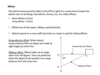
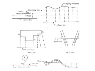
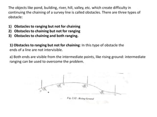
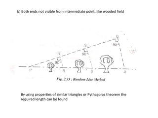
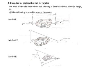
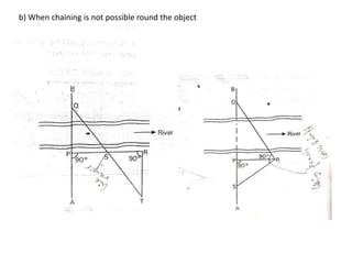
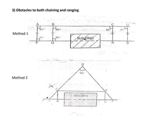
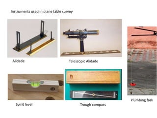
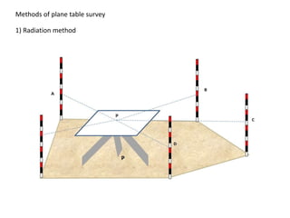
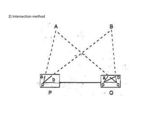
SlideShare a Scribd company logo
Offsets
The lateral measurements taken to the left or right of a survey line to locate the
details such as buildings, boundaries, fences, etc, are called offsets.
• Short offsets (<15m)
Long offsets (>15m)
• Offsets are of two types: oblique, perpendicular.
• Optical square or a cross staff and chain or a tape is used for taking offsets.
Perpendicular offset: When lateral
measurements from an object are made at
right angles to chain line.
Oblique offset: Offsets taken at an angle
other than 90 degree. They are preferred
when the object to be located is at a long
distance from the chain line.
OBSTACLES IN CHAIN SURVEYING
The objects like pond, building, river, hill, valley, etc. which create difficulty in
continuing the chaining of a survey line is called obstacles. There are three types of
obstacle:
1) Obstacles to ranging but not for chaining
2) Obstacles to chaining but not for ranging
3) Obstacles to chaining and both ranging.
1) Obstacles to ranging but not for chaining: In this type of obstacle the
ends of a line are not intervisible.
a) Both ends are visible from the intermediate points, like rising ground: intermediate
ranging can be used to overcome the problem.
b) Both ends not visible from intermediate point, like wooded field
By using properties of similar triangles or Pythagoras theorem the
required length can be found
2. Obstacles for chaining but not for ranging
The ends of line are inter-visible but chaining is obstructed by a pond or hedge,
etc.
Method 1
Method 2
Method 3
a) When chaining is possible around the object
b) When chaining is not possible round the object
3) Obstacles to both chaining and ranging
Method 1
Method 2
PLANE TABLE SURVEY
• Graphical method- Field work and plotting done simultaneously
• Adopted in small mapping
• For filling details in map already prepared
• Consists of a drawing board provided with a ball and socket arrangement for
leveling the table, with arrangement to fix table to a tripod
Instruments used in plane table survey
Alidade Telescopic Alidade
Spirit level Trough compass
Plumbing fork
Methods of plane table survey
1) Radiation method
2) Intersection method
Advantages of Plane Table Surveying
• Suitable for location of details as well as contouring for large scale maps directly in the
field.
• Chances of omitting of any detail is less as surveying and plotting are done
simultaneously
• Errors and accuracy of the plot can be ascertained as the plotted details get compared
with actual objects present in the field
• Contours and specific features can be represented and checked conveniently as the
whole area is in view at the time of plotting
• Only relevant details are located because the map is drawn as the survey progresses.
Irrelevant details can be omitted on the field itself.
• Rapid and less costly than other types of survey
• As the instruments used are simple, not much skill for operation of instruments is
required. This method of survey requires no field book.
Disadvantage of Plane Table Surveying
• The plane table survey is not possible in unfavourable climate such as rain, fog,
etc.
• This method of survey is not very accurate and thus unsuitable for large scale or
precise work
• As no field book is maintained, plotting at different scale require full exercise.
• The method requires large amount of time to be spent in the field.
• Quality of the final map depends largely on the drafting capability of the
surveyor.
• This method is effective in relatively open country where stations can be sighted
easily.

More Related Content

What's hot

Drone survey
Drone surveyDrone survey
Drone survey
ShramikMane1
 
Modern surveying techniques
Modern surveying techniquesModern surveying techniques
Modern surveying techniques
Sunny Jaiswal
 
Hydrographic Surveying
Hydrographic SurveyingHydrographic Surveying
Hydrographic Surveying
Amira Abdallah
 
Basics of remote sensing, pk mani
Basics of remote sensing, pk maniBasics of remote sensing, pk mani
Basics of remote sensing, pk mani
P.K. Mani
 
DGPS
DGPSDGPS
Dgps seminar
Dgps seminarDgps seminar
Dgps seminar
anand0030
 
GIS and spatial-modelling
GIS and spatial-modellingGIS and spatial-modelling
GIS and spatial-modellingJulian Swindell
 
GROUND PENETRATING RADAR(GPR) ppt
GROUND PENETRATING RADAR(GPR) ppt GROUND PENETRATING RADAR(GPR) ppt
GROUND PENETRATING RADAR(GPR) ppt
Himanshu Yadav
 
Remote Sensing fundamentals
Remote Sensing fundamentalsRemote Sensing fundamentals
Remote Sensing fundamentalsMohammed_82
 
introduction-of-GNSS-1
introduction-of-GNSS-1introduction-of-GNSS-1
introduction-of-GNSS-1
Kutubuddin ANSARI
 
Global positioning system ppt
Global positioning system pptGlobal positioning system ppt
Global positioning system ppt
Sushant Maurya
 
chapter 4.ppt
chapter 4.pptchapter 4.ppt
chapter 4.ppt
ThomasHundasa1
 
MODERN SURVEYING TECHNIQUES
MODERN SURVEYING TECHNIQUESMODERN SURVEYING TECHNIQUES
DGPS PPT.ppt
DGPS PPT.pptDGPS PPT.ppt
DGPS PPT.ppt
SamiDan2
 
DIFFERENTIAL GPS (DGPS)
DIFFERENTIAL GPS (DGPS)DIFFERENTIAL GPS (DGPS)
DIFFERENTIAL GPS (DGPS)
KU Leuven
 
Satellite 101
Satellite 101Satellite 101
Satellite 101
Colleen Jack
 
Geographical information system by zewde alemayehu tilahun
Geographical information system by zewde alemayehu tilahunGeographical information system by zewde alemayehu tilahun
Geographical information system by zewde alemayehu tilahun
zewde alemayehu
 
Basic principels of REMOTE SENSING
Basic principels of  REMOTE SENSINGBasic principels of  REMOTE SENSING
Basic principels of REMOTE SENSING
Ghassan Hadi
 
Errors and biasis
Errors and biasisErrors and biasis
Errors and biasis
gayathrysatheesan1
 
GPS-errors-1
GPS-errors-1GPS-errors-1
GPS-errors-1
Kutubuddin ANSARI
 

What's hot (20)

Drone survey
Drone surveyDrone survey
Drone survey
 
Modern surveying techniques
Modern surveying techniquesModern surveying techniques
Modern surveying techniques
 
Hydrographic Surveying
Hydrographic SurveyingHydrographic Surveying
Hydrographic Surveying
 
Basics of remote sensing, pk mani
Basics of remote sensing, pk maniBasics of remote sensing, pk mani
Basics of remote sensing, pk mani
 
DGPS
DGPSDGPS
DGPS
 
Dgps seminar
Dgps seminarDgps seminar
Dgps seminar
 
GIS and spatial-modelling
GIS and spatial-modellingGIS and spatial-modelling
GIS and spatial-modelling
 
GROUND PENETRATING RADAR(GPR) ppt
GROUND PENETRATING RADAR(GPR) ppt GROUND PENETRATING RADAR(GPR) ppt
GROUND PENETRATING RADAR(GPR) ppt
 
Remote Sensing fundamentals
Remote Sensing fundamentalsRemote Sensing fundamentals
Remote Sensing fundamentals
 
introduction-of-GNSS-1
introduction-of-GNSS-1introduction-of-GNSS-1
introduction-of-GNSS-1
 
Global positioning system ppt
Global positioning system pptGlobal positioning system ppt
Global positioning system ppt
 
chapter 4.ppt
chapter 4.pptchapter 4.ppt
chapter 4.ppt
 
MODERN SURVEYING TECHNIQUES
MODERN SURVEYING TECHNIQUESMODERN SURVEYING TECHNIQUES
MODERN SURVEYING TECHNIQUES
 
DGPS PPT.ppt
DGPS PPT.pptDGPS PPT.ppt
DGPS PPT.ppt
 
DIFFERENTIAL GPS (DGPS)
DIFFERENTIAL GPS (DGPS)DIFFERENTIAL GPS (DGPS)
DIFFERENTIAL GPS (DGPS)
 
Satellite 101
Satellite 101Satellite 101
Satellite 101
 
Geographical information system by zewde alemayehu tilahun
Geographical information system by zewde alemayehu tilahunGeographical information system by zewde alemayehu tilahun
Geographical information system by zewde alemayehu tilahun
 
Basic principels of REMOTE SENSING
Basic principels of  REMOTE SENSINGBasic principels of  REMOTE SENSING
Basic principels of REMOTE SENSING
 
Errors and biasis
Errors and biasisErrors and biasis
Errors and biasis
 
GPS-errors-1
GPS-errors-1GPS-errors-1
GPS-errors-1
 

Similar to Offsets, obstacles and plane table- AV.pptx

Unit 2
Unit 2Unit 2
Unit 2
Nishma2
 
Basic Civil and Mechanical Engineering
Basic Civil and Mechanical EngineeringBasic Civil and Mechanical Engineering
Basic Civil and Mechanical Engineering
PAAVAI ENGINEERING COLLEGE
 
1.5_Basic Engineering_Day 7.pptx
1.5_Basic Engineering_Day 7.pptx1.5_Basic Engineering_Day 7.pptx
1.5_Basic Engineering_Day 7.pptx
Janak82
 
surveyf tururu ururtu65 6ru5uu56 686585 868
surveyf tururu ururtu65 6ru5uu56 686585 868surveyf tururu ururtu65 6ru5uu56 686585 868
surveyf tururu ururtu65 6ru5uu56 686585 868
RahulSinghParihar18
 
1. Intro to Surveying.pdf
1. Intro to Surveying.pdf1. Intro to Surveying.pdf
1. Intro to Surveying.pdf
DivyaPriya700213
 
Surveying pdf
Surveying pdfSurveying pdf
Surveying pdf
Saqib Imran
 
Chain Surveying 2020.ppt
 Chain Surveying 2020.ppt Chain Surveying 2020.ppt
Chain Surveying 2020.ppt
AsadKhan606012
 
Triangulation survey
Triangulation surveyTriangulation survey
Triangulation survey
HastarajPandey
 
Contouring
ContouringContouring
Contouring
GAURAV. H .TANDON
 
Distance Measurement & Chain Surveying
Distance Measurement & Chain SurveyingDistance Measurement & Chain Surveying
Distance Measurement & Chain Surveying
Bahzad5
 
contouring-180417110533.pdf
contouring-180417110533.pdfcontouring-180417110533.pdf
contouring-180417110533.pdf
shucaybcabdi
 
Contouring
ContouringContouring
Contouring
SachinGunjal7
 
UNIT 1_Chapter 2_Adv Survey.pptx
UNIT 1_Chapter 2_Adv Survey.pptxUNIT 1_Chapter 2_Adv Survey.pptx
UNIT 1_Chapter 2_Adv Survey.pptx
Mrunmayee Manjari
 
Basic civil
Basic civilBasic civil
Basic civil
sreejithksasidharan
 
Surveying part 1 unit 1 and 2
Surveying part 1 unit 1 and 2Surveying part 1 unit 1 and 2
Surveying part 1 unit 1 and 2
Warish Khan
 
Diploma(civil) sem i boce_unit 2_ elementary surveying a
Diploma(civil) sem i boce_unit 2_ elementary surveying aDiploma(civil) sem i boce_unit 2_ elementary surveying a
Diploma(civil) sem i boce_unit 2_ elementary surveying a
Rai University
 
Diploma(civil) sem i boce_unit 2_ elementary surveying a
Diploma(civil) sem i boce_unit 2_ elementary surveying aDiploma(civil) sem i boce_unit 2_ elementary surveying a
Diploma(civil) sem i boce_unit 2_ elementary surveying a
Rai University
 
Introduction to surveying, ranging and chaining
Introduction to surveying, ranging and chainingIntroduction to surveying, ranging and chaining
Introduction to surveying, ranging and chaining
Shital Navghare
 

Similar to Offsets, obstacles and plane table- AV.pptx (20)

Unit 2
Unit 2Unit 2
Unit 2
 
Basic Civil and Mechanical Engineering
Basic Civil and Mechanical EngineeringBasic Civil and Mechanical Engineering
Basic Civil and Mechanical Engineering
 
1.5_Basic Engineering_Day 7.pptx
1.5_Basic Engineering_Day 7.pptx1.5_Basic Engineering_Day 7.pptx
1.5_Basic Engineering_Day 7.pptx
 
surveyf tururu ururtu65 6ru5uu56 686585 868
surveyf tururu ururtu65 6ru5uu56 686585 868surveyf tururu ururtu65 6ru5uu56 686585 868
surveyf tururu ururtu65 6ru5uu56 686585 868
 
1. Intro to Surveying.pdf
1. Intro to Surveying.pdf1. Intro to Surveying.pdf
1. Intro to Surveying.pdf
 
Surveying
Surveying Surveying
Surveying
 
Surveying pdf
Surveying pdfSurveying pdf
Surveying pdf
 
Chain Surveying 2020.ppt
 Chain Surveying 2020.ppt Chain Surveying 2020.ppt
Chain Surveying 2020.ppt
 
Triangulation survey
Triangulation surveyTriangulation survey
Triangulation survey
 
Contouring
ContouringContouring
Contouring
 
Distance Measurement & Chain Surveying
Distance Measurement & Chain SurveyingDistance Measurement & Chain Surveying
Distance Measurement & Chain Surveying
 
contouring-180417110533.pdf
contouring-180417110533.pdfcontouring-180417110533.pdf
contouring-180417110533.pdf
 
Contouring
ContouringContouring
Contouring
 
30838893 chain-survey
30838893 chain-survey30838893 chain-survey
30838893 chain-survey
 
UNIT 1_Chapter 2_Adv Survey.pptx
UNIT 1_Chapter 2_Adv Survey.pptxUNIT 1_Chapter 2_Adv Survey.pptx
UNIT 1_Chapter 2_Adv Survey.pptx
 
Basic civil
Basic civilBasic civil
Basic civil
 
Surveying part 1 unit 1 and 2
Surveying part 1 unit 1 and 2Surveying part 1 unit 1 and 2
Surveying part 1 unit 1 and 2
 
Diploma(civil) sem i boce_unit 2_ elementary surveying a
Diploma(civil) sem i boce_unit 2_ elementary surveying aDiploma(civil) sem i boce_unit 2_ elementary surveying a
Diploma(civil) sem i boce_unit 2_ elementary surveying a
 
Diploma(civil) sem i boce_unit 2_ elementary surveying a
Diploma(civil) sem i boce_unit 2_ elementary surveying aDiploma(civil) sem i boce_unit 2_ elementary surveying a
Diploma(civil) sem i boce_unit 2_ elementary surveying a
 
Introduction to surveying, ranging and chaining
Introduction to surveying, ranging and chainingIntroduction to surveying, ranging and chaining
Introduction to surveying, ranging and chaining
 

Recently uploaded

DfMAy 2024 - key insights and contributions
DfMAy 2024 - key insights and contributionsDfMAy 2024 - key insights and contributions
DfMAy 2024 - key insights and contributions
gestioneergodomus
 
BPV-GUI-01-Guide-for-ASME-Review-Teams-(General)-10-10-2023.pdf
BPV-GUI-01-Guide-for-ASME-Review-Teams-(General)-10-10-2023.pdfBPV-GUI-01-Guide-for-ASME-Review-Teams-(General)-10-10-2023.pdf
BPV-GUI-01-Guide-for-ASME-Review-Teams-(General)-10-10-2023.pdf
MIGUELANGEL966976
 
Technical Drawings introduction to drawing of prisms
Technical Drawings introduction to drawing of prismsTechnical Drawings introduction to drawing of prisms
Technical Drawings introduction to drawing of prisms
heavyhaig
 
Planning Of Procurement o different goods and services
Planning Of Procurement o different goods and servicesPlanning Of Procurement o different goods and services
Planning Of Procurement o different goods and services
JoytuBarua2
 
[JPP-1] - (JEE 3.0) - Kinematics 1D - 14th May..pdf
[JPP-1] - (JEE 3.0) - Kinematics 1D - 14th May..pdf[JPP-1] - (JEE 3.0) - Kinematics 1D - 14th May..pdf
[JPP-1] - (JEE 3.0) - Kinematics 1D - 14th May..pdf
awadeshbabu
 
ACEP Magazine edition 4th launched on 05.06.2024
ACEP Magazine edition 4th launched on 05.06.2024ACEP Magazine edition 4th launched on 05.06.2024
ACEP Magazine edition 4th launched on 05.06.2024
Rahul
 
Nuclear Power Economics and Structuring 2024
Nuclear Power Economics and Structuring 2024Nuclear Power Economics and Structuring 2024
Nuclear Power Economics and Structuring 2024
Massimo Talia
 
Water billing management system project report.pdf
Water billing management system project report.pdfWater billing management system project report.pdf
Water billing management system project report.pdf
Kamal Acharya
 
digital fundamental by Thomas L.floydl.pdf
digital fundamental by Thomas L.floydl.pdfdigital fundamental by Thomas L.floydl.pdf
digital fundamental by Thomas L.floydl.pdf
drwaing
 
Swimming pool mechanical components design.pptx
Swimming pool  mechanical components design.pptxSwimming pool  mechanical components design.pptx
Swimming pool mechanical components design.pptx
yokeleetan1
 
一比一原版(UofT毕业证)多伦多大学毕业证成绩单如何办理
一比一原版(UofT毕业证)多伦多大学毕业证成绩单如何办理一比一原版(UofT毕业证)多伦多大学毕业证成绩单如何办理
一比一原版(UofT毕业证)多伦多大学毕业证成绩单如何办理
ydteq
 
KuberTENes Birthday Bash Guadalajara - K8sGPT first impressions
KuberTENes Birthday Bash Guadalajara - K8sGPT first impressionsKuberTENes Birthday Bash Guadalajara - K8sGPT first impressions
KuberTENes Birthday Bash Guadalajara - K8sGPT first impressions
Victor Morales
 
Building Electrical System Design & Installation
Building Electrical System Design & InstallationBuilding Electrical System Design & Installation
Building Electrical System Design & Installation
symbo111
 
PPT on GRP pipes manufacturing and testing
PPT on GRP pipes manufacturing and testingPPT on GRP pipes manufacturing and testing
PPT on GRP pipes manufacturing and testing
anoopmanoharan2
 
Fundamentals of Electric Drives and its applications.pptx
Fundamentals of Electric Drives and its applications.pptxFundamentals of Electric Drives and its applications.pptx
Fundamentals of Electric Drives and its applications.pptx
manasideore6
 
Online aptitude test management system project report.pdf
Online aptitude test management system project report.pdfOnline aptitude test management system project report.pdf
Online aptitude test management system project report.pdf
Kamal Acharya
 
RAT: Retrieval Augmented Thoughts Elicit Context-Aware Reasoning in Long-Hori...
RAT: Retrieval Augmented Thoughts Elicit Context-Aware Reasoning in Long-Hori...RAT: Retrieval Augmented Thoughts Elicit Context-Aware Reasoning in Long-Hori...
RAT: Retrieval Augmented Thoughts Elicit Context-Aware Reasoning in Long-Hori...
thanhdowork
 
A review on techniques and modelling methodologies used for checking electrom...
A review on techniques and modelling methodologies used for checking electrom...A review on techniques and modelling methodologies used for checking electrom...
A review on techniques and modelling methodologies used for checking electrom...
nooriasukmaningtyas
 
PROJECT FORMAT FOR EVS AMITY UNIVERSITY GWALIOR.ppt
PROJECT FORMAT FOR EVS AMITY UNIVERSITY GWALIOR.pptPROJECT FORMAT FOR EVS AMITY UNIVERSITY GWALIOR.ppt
PROJECT FORMAT FOR EVS AMITY UNIVERSITY GWALIOR.ppt
bhadouriyakaku
 
Recycled Concrete Aggregate in Construction Part III
Recycled Concrete Aggregate in Construction Part IIIRecycled Concrete Aggregate in Construction Part III
Recycled Concrete Aggregate in Construction Part III
Aditya Rajan Patra
 

Recently uploaded (20)

DfMAy 2024 - key insights and contributions
DfMAy 2024 - key insights and contributionsDfMAy 2024 - key insights and contributions
DfMAy 2024 - key insights and contributions
 
BPV-GUI-01-Guide-for-ASME-Review-Teams-(General)-10-10-2023.pdf
BPV-GUI-01-Guide-for-ASME-Review-Teams-(General)-10-10-2023.pdfBPV-GUI-01-Guide-for-ASME-Review-Teams-(General)-10-10-2023.pdf
BPV-GUI-01-Guide-for-ASME-Review-Teams-(General)-10-10-2023.pdf
 
Technical Drawings introduction to drawing of prisms
Technical Drawings introduction to drawing of prismsTechnical Drawings introduction to drawing of prisms
Technical Drawings introduction to drawing of prisms
 
Planning Of Procurement o different goods and services
Planning Of Procurement o different goods and servicesPlanning Of Procurement o different goods and services
Planning Of Procurement o different goods and services
 
[JPP-1] - (JEE 3.0) - Kinematics 1D - 14th May..pdf
[JPP-1] - (JEE 3.0) - Kinematics 1D - 14th May..pdf[JPP-1] - (JEE 3.0) - Kinematics 1D - 14th May..pdf
[JPP-1] - (JEE 3.0) - Kinematics 1D - 14th May..pdf
 
ACEP Magazine edition 4th launched on 05.06.2024
ACEP Magazine edition 4th launched on 05.06.2024ACEP Magazine edition 4th launched on 05.06.2024
ACEP Magazine edition 4th launched on 05.06.2024
 
Nuclear Power Economics and Structuring 2024
Nuclear Power Economics and Structuring 2024Nuclear Power Economics and Structuring 2024
Nuclear Power Economics and Structuring 2024
 
Water billing management system project report.pdf
Water billing management system project report.pdfWater billing management system project report.pdf
Water billing management system project report.pdf
 
digital fundamental by Thomas L.floydl.pdf
digital fundamental by Thomas L.floydl.pdfdigital fundamental by Thomas L.floydl.pdf
digital fundamental by Thomas L.floydl.pdf
 
Swimming pool mechanical components design.pptx
Swimming pool  mechanical components design.pptxSwimming pool  mechanical components design.pptx
Swimming pool mechanical components design.pptx
 
一比一原版(UofT毕业证)多伦多大学毕业证成绩单如何办理
一比一原版(UofT毕业证)多伦多大学毕业证成绩单如何办理一比一原版(UofT毕业证)多伦多大学毕业证成绩单如何办理
一比一原版(UofT毕业证)多伦多大学毕业证成绩单如何办理
 
KuberTENes Birthday Bash Guadalajara - K8sGPT first impressions
KuberTENes Birthday Bash Guadalajara - K8sGPT first impressionsKuberTENes Birthday Bash Guadalajara - K8sGPT first impressions
KuberTENes Birthday Bash Guadalajara - K8sGPT first impressions
 
Building Electrical System Design & Installation
Building Electrical System Design & InstallationBuilding Electrical System Design & Installation
Building Electrical System Design & Installation
 
PPT on GRP pipes manufacturing and testing
PPT on GRP pipes manufacturing and testingPPT on GRP pipes manufacturing and testing
PPT on GRP pipes manufacturing and testing
 
Fundamentals of Electric Drives and its applications.pptx
Fundamentals of Electric Drives and its applications.pptxFundamentals of Electric Drives and its applications.pptx
Fundamentals of Electric Drives and its applications.pptx
 
Online aptitude test management system project report.pdf
Online aptitude test management system project report.pdfOnline aptitude test management system project report.pdf
Online aptitude test management system project report.pdf
 
RAT: Retrieval Augmented Thoughts Elicit Context-Aware Reasoning in Long-Hori...
RAT: Retrieval Augmented Thoughts Elicit Context-Aware Reasoning in Long-Hori...RAT: Retrieval Augmented Thoughts Elicit Context-Aware Reasoning in Long-Hori...
RAT: Retrieval Augmented Thoughts Elicit Context-Aware Reasoning in Long-Hori...
 
A review on techniques and modelling methodologies used for checking electrom...
A review on techniques and modelling methodologies used for checking electrom...A review on techniques and modelling methodologies used for checking electrom...
A review on techniques and modelling methodologies used for checking electrom...
 
PROJECT FORMAT FOR EVS AMITY UNIVERSITY GWALIOR.ppt
PROJECT FORMAT FOR EVS AMITY UNIVERSITY GWALIOR.pptPROJECT FORMAT FOR EVS AMITY UNIVERSITY GWALIOR.ppt
PROJECT FORMAT FOR EVS AMITY UNIVERSITY GWALIOR.ppt
 
Recycled Concrete Aggregate in Construction Part III
Recycled Concrete Aggregate in Construction Part IIIRecycled Concrete Aggregate in Construction Part III
Recycled Concrete Aggregate in Construction Part III
 

Offsets, obstacles and plane table- AV.pptx

  • 1. Offsets The lateral measurements taken to the left or right of a survey line to locate the details such as buildings, boundaries, fences, etc, are called offsets. • Short offsets (<15m) Long offsets (>15m) • Offsets are of two types: oblique, perpendicular. • Optical square or a cross staff and chain or a tape is used for taking offsets. Perpendicular offset: When lateral measurements from an object are made at right angles to chain line. Oblique offset: Offsets taken at an angle other than 90 degree. They are preferred when the object to be located is at a long distance from the chain line.
  • 2.
  • 3. OBSTACLES IN CHAIN SURVEYING
  • 4. The objects like pond, building, river, hill, valley, etc. which create difficulty in continuing the chaining of a survey line is called obstacles. There are three types of obstacle: 1) Obstacles to ranging but not for chaining 2) Obstacles to chaining but not for ranging 3) Obstacles to chaining and both ranging. 1) Obstacles to ranging but not for chaining: In this type of obstacle the ends of a line are not intervisible. a) Both ends are visible from the intermediate points, like rising ground: intermediate ranging can be used to overcome the problem.
  • 5. b) Both ends not visible from intermediate point, like wooded field By using properties of similar triangles or Pythagoras theorem the required length can be found
  • 6. 2. Obstacles for chaining but not for ranging The ends of line are inter-visible but chaining is obstructed by a pond or hedge, etc. Method 1 Method 2 Method 3 a) When chaining is possible around the object
  • 7. b) When chaining is not possible round the object
  • 8. 3) Obstacles to both chaining and ranging Method 1 Method 2
  • 10. • Graphical method- Field work and plotting done simultaneously • Adopted in small mapping • For filling details in map already prepared • Consists of a drawing board provided with a ball and socket arrangement for leveling the table, with arrangement to fix table to a tripod
  • 11. Instruments used in plane table survey Alidade Telescopic Alidade Spirit level Trough compass Plumbing fork
  • 12. Methods of plane table survey 1) Radiation method
  • 14. Advantages of Plane Table Surveying • Suitable for location of details as well as contouring for large scale maps directly in the field. • Chances of omitting of any detail is less as surveying and plotting are done simultaneously • Errors and accuracy of the plot can be ascertained as the plotted details get compared with actual objects present in the field • Contours and specific features can be represented and checked conveniently as the whole area is in view at the time of plotting • Only relevant details are located because the map is drawn as the survey progresses. Irrelevant details can be omitted on the field itself. • Rapid and less costly than other types of survey • As the instruments used are simple, not much skill for operation of instruments is required. This method of survey requires no field book.
  • 15. Disadvantage of Plane Table Surveying • The plane table survey is not possible in unfavourable climate such as rain, fog, etc. • This method of survey is not very accurate and thus unsuitable for large scale or precise work • As no field book is maintained, plotting at different scale require full exercise. • The method requires large amount of time to be spent in the field. • Quality of the final map depends largely on the drafting capability of the surveyor. • This method is effective in relatively open country where stations can be sighted easily.