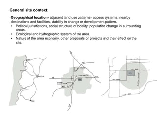
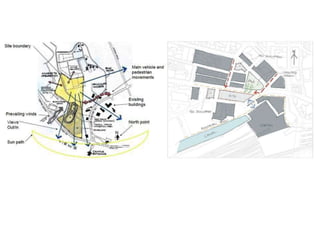
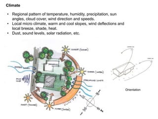
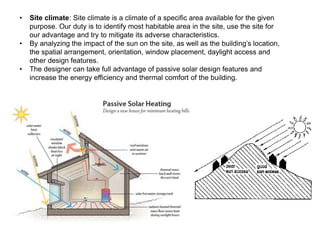
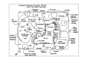
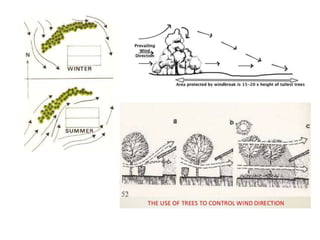
SITE ANALYSIS
4 main aspects to Site Analysis
• General Site context
• Physical data
• Cultural data
• Correlation of data
General site context:
Geographical location- adjacent land use patterns- access systems, nearby
destinations and facilities, stability in change or development pattern.
• Political jurisdictions, social structure of locality, population change in surrounding
areas.
• Ecological and hydrographic system of the area.
• Nature of the area economy, other proposals or projects and their effect on the
site.
Physical Data
• Geology and soil
• Water
• Topography
• Climate
• Ecology
• Man made features
• Sensory qualities
Geology and soil
• Underlying geology, rock character and depth
• Soil types, value and engineering and plant material, presence of
chemicals
• Areas for fill or ledge, liability to slides, etc.
Water/ Hydrology
• Existing water bodies
• Natural and man made drainage channel- flow capacity and
purity
• Surface drainage pattern- amount, direction, blockage, flood
zones, undrained depressions, areas of continuing erosion
• Water table
• Water supply
Topography
• Pattern of landform- typology, slopes, circulation possibilities, access
points, barriers, visibility
• Unique features
• If a site is flat, the topography may not influence the location and
layout of the building, but on a sloping site, the topography is likely to
be significant design factor
• The location and layout of the building should be designed to minimize
the need for excavation or fill as well as increasing costs.
• Large scale earth works increase the risk of erosion by altering soil
stability and water run-off patterns, increase sediment run-off during
construction and significantly affect biodiversity by removing soils and
plants.
Contour model
Climate
• Regional pattern of temperature, humidity, precipitation, sun
angles, cloud cover, wind direction and speeds.
• Local micro climate, warm and cool slopes, wind deflections and
local breeze, shade, heat.
• Dust, sound levels, solar radiation, etc.
Orientation
• Site climate: Site climate is a climate of a specific area available for the given
purpose. Our duty is to identify most habitable area in the site, use the site for
our advantage and try to mitigate its adverse characteristics.
• By analyzing the impact of the sun on the site, as well as the building’s location,
the spatial arrangement, orientation, window placement, daylight access and
other design features.
• The designer can take full advantage of passive solar design features and
increase the energy efficiency and thermal comfort of the building.
Ecology
• Dominant plant and animal community
• General pattern of plant cover, quality of wooded areas, regeneration potential
• Specimen trees- their location, spread, species, elevation of base, support
system needed.
• Existing trees and plants on site should be assessed for their value to the site-
provide shade, wind shelter, soil stability and a habitat for birds.
• They also provide aesthetic value and if removed, take many years to replace
• Design and locate the building to accommodate existing trees.
• Age and condition of trees- risk of damage to the completed building, the impact
of building’s proximity to an existing tree- a building too close to a tree may affect
its long-term viability.
• The possibility of incorporating a tree or shrub into the building design, for
example, designing a house or a deck around it, trees that are protected under
the District plan or site-specific documents such as an open space covenant
must be retained.
• Retain existing vegetation to reduce the risk of soil erosion, slips and sediment
run-off from the site. Where removal of topsoil and planting is necessary, specify
limiting the amount of topsoil stripping to the building area, careful removal,
storage and reinstatement when the building work is complete.
Man made structures
• Existing buildings: location, outline, type, etc
• Networks: roads, pathways, sewer, gas, water, electricity lines, etc,
• Fences, walls, decks, or other human modifications.
1. Design considerations include avoiding:
2. Shading from neighbouring buildings
3. Causing unreasonable shading to neighbouring buildings
4. Loss of privacy to occupants and neighbours
• Regardless of whether an adjacent site is vacant, District plans restrict
proximity to boundaries and have sun access or height recession
planes that protect adjacent properties against unreasonable shading,
loss of sunlight and loss of privacy.
• Mitigate any possible adverse effects in the future:
1. Consider what may be built on an adjacent site
2. Locate the building as far from the adjoining boundary as possible
3. Locate the building on a elevated part of the site to ensure views or
sunlight is maintained
4. Allow for factors such as trees growing larger on adjacent sites.
Larger sites Smaller sites
• Transformers
• Any built structure
• Well
• Shed
• Garden bridges
• Pathway
• Electrical pole
Man made features
Sensory qualities
• Character and relationship of visual spaces and sequences
• View points, vistas and focal points
• Quality and variation of light, sound and smell.
3. Cultural data
• Resident and using population
• Behaviour settings: nature, location, participants, rhythm
• Site values, rights, restraints: political jurisdictions
• Past and future
• Site character and images
4. Correlation of Data
• Subdivisions of site: areas of consistent structure, character, problems
• Identification of key points, axes, areas best left undeveloped, areas
where intensive development is possible
• Ongoing changes, those likely to occur without any intervention- the
dynamic aspect of site
• Ties to context- current and possible linkages, areas where consistent
uses are desirable, patterns of movements to be preserved.
• Summary of significant problems and potentials, including positive and
negative impacts on site.
THANK YOU

Site analysis- AV.pptx

  • 1.
  • 2.
    4 main aspectsto Site Analysis • General Site context • Physical data • Cultural data • Correlation of data
  • 3.
    General site context: Geographicallocation- adjacent land use patterns- access systems, nearby destinations and facilities, stability in change or development pattern. • Political jurisdictions, social structure of locality, population change in surrounding areas. • Ecological and hydrographic system of the area. • Nature of the area economy, other proposals or projects and their effect on the site.
  • 5.
    Physical Data • Geologyand soil • Water • Topography • Climate • Ecology • Man made features • Sensory qualities
  • 6.
    Geology and soil •Underlying geology, rock character and depth • Soil types, value and engineering and plant material, presence of chemicals • Areas for fill or ledge, liability to slides, etc.
  • 7.
    Water/ Hydrology • Existingwater bodies • Natural and man made drainage channel- flow capacity and purity • Surface drainage pattern- amount, direction, blockage, flood zones, undrained depressions, areas of continuing erosion • Water table • Water supply
  • 9.
    Topography • Pattern oflandform- typology, slopes, circulation possibilities, access points, barriers, visibility • Unique features • If a site is flat, the topography may not influence the location and layout of the building, but on a sloping site, the topography is likely to be significant design factor • The location and layout of the building should be designed to minimize the need for excavation or fill as well as increasing costs. • Large scale earth works increase the risk of erosion by altering soil stability and water run-off patterns, increase sediment run-off during construction and significantly affect biodiversity by removing soils and plants.
  • 10.
  • 12.
    Climate • Regional patternof temperature, humidity, precipitation, sun angles, cloud cover, wind direction and speeds. • Local micro climate, warm and cool slopes, wind deflections and local breeze, shade, heat. • Dust, sound levels, solar radiation, etc. Orientation
  • 13.
    • Site climate:Site climate is a climate of a specific area available for the given purpose. Our duty is to identify most habitable area in the site, use the site for our advantage and try to mitigate its adverse characteristics. • By analyzing the impact of the sun on the site, as well as the building’s location, the spatial arrangement, orientation, window placement, daylight access and other design features. • The designer can take full advantage of passive solar design features and increase the energy efficiency and thermal comfort of the building.
  • 14.
    Ecology • Dominant plantand animal community • General pattern of plant cover, quality of wooded areas, regeneration potential • Specimen trees- their location, spread, species, elevation of base, support system needed. • Existing trees and plants on site should be assessed for their value to the site- provide shade, wind shelter, soil stability and a habitat for birds. • They also provide aesthetic value and if removed, take many years to replace • Design and locate the building to accommodate existing trees. • Age and condition of trees- risk of damage to the completed building, the impact of building’s proximity to an existing tree- a building too close to a tree may affect its long-term viability. • The possibility of incorporating a tree or shrub into the building design, for example, designing a house or a deck around it, trees that are protected under the District plan or site-specific documents such as an open space covenant must be retained. • Retain existing vegetation to reduce the risk of soil erosion, slips and sediment run-off from the site. Where removal of topsoil and planting is necessary, specify limiting the amount of topsoil stripping to the building area, careful removal, storage and reinstatement when the building work is complete.
  • 17.
    Man made structures •Existing buildings: location, outline, type, etc • Networks: roads, pathways, sewer, gas, water, electricity lines, etc, • Fences, walls, decks, or other human modifications. 1. Design considerations include avoiding: 2. Shading from neighbouring buildings 3. Causing unreasonable shading to neighbouring buildings 4. Loss of privacy to occupants and neighbours • Regardless of whether an adjacent site is vacant, District plans restrict proximity to boundaries and have sun access or height recession planes that protect adjacent properties against unreasonable shading, loss of sunlight and loss of privacy. • Mitigate any possible adverse effects in the future: 1. Consider what may be built on an adjacent site 2. Locate the building as far from the adjoining boundary as possible 3. Locate the building on a elevated part of the site to ensure views or sunlight is maintained 4. Allow for factors such as trees growing larger on adjacent sites.
  • 18.
    Larger sites Smallersites • Transformers • Any built structure • Well • Shed • Garden bridges • Pathway • Electrical pole Man made features
  • 19.
    Sensory qualities • Characterand relationship of visual spaces and sequences • View points, vistas and focal points • Quality and variation of light, sound and smell.
  • 20.
    3. Cultural data •Resident and using population • Behaviour settings: nature, location, participants, rhythm • Site values, rights, restraints: political jurisdictions • Past and future • Site character and images 4. Correlation of Data • Subdivisions of site: areas of consistent structure, character, problems • Identification of key points, axes, areas best left undeveloped, areas where intensive development is possible • Ongoing changes, those likely to occur without any intervention- the dynamic aspect of site • Ties to context- current and possible linkages, areas where consistent uses are desirable, patterns of movements to be preserved. • Summary of significant problems and potentials, including positive and negative impacts on site.
  • 21.