
Recommended
More Related Content
What's hot
What's hot (20)
Similar to Map making and elementary surveying
Similar to Map making and elementary surveying (20)
More from MussaOmary3
More from MussaOmary3 (20)
Recently uploaded
Recently uploaded (20)
Map making and elementary surveying
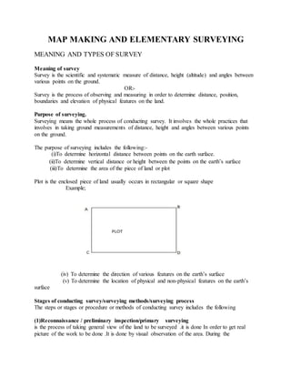
- 1. MAP MAKING AND ELEMENTARY SURVEYING MEANING AND TYPES OF SURVEY Meaning of survey Survey is the scientific and systematic measure of distance, height (altitude) and angles between various points on the ground. OR:- Survey is the process of observing and measuring in order to determine distance, position, boundaries and elevation of physical features on the land. Purpose of surveying. Surveying means the whole process of conducting survey. It involves the whole practices that involves in taking ground measurements of distance, height and angles between various points on the ground. The purpose of surveying includes the following:- (i)To determine horizontal distance between points on the earth surface. (ii)To determine vertical distance or height between the points on the earth’s surface (iii)To determine the area of the piece of land or plot Plot is the enclosed piece of land usually occurs in rectangular or square shape Example; (iv) To determine the direction of various features on the earth’s surface (v) To determine the location of physical and non-physical features on the earth’s surface Stages of conducting survey/surveying methods/surveying process The steps or stages or procedure or methods of conducting survey includes the following (1)Reconnaissance / preliminary inspection/primary surveying is the process of taking general view of the land to be surveyed .it is done In order to get real picture of the work to be done .It is done by visual observation of the area. During the
- 2. reconnaissance the surveyor does walking around the area to be surveyed and taking general views and noting down the dominant features area - Boundaries of the area - Corners of the boundaries of the area - Other structures such as building, big trees, ponds, lakes, small hills e.t.c Importance of reconnaissance (i)It helps to get the full picture of the survey to be conducted (ii)It helps for choosing the scale for map making (iii)It makes survey for new coordinates and old coordinate easier (iv)It shows the existing situation on a piece of paper (2)Actual survey /secondary survey This steps involved observing, measuring and recording direction, angles distance and elevation by using surveying equipments or tools. (3)Presentation this involves presentation of data or information collected or recorded,the information can be presented by writing or drawing form BRANCHES /TYPES OF LAND SURVEYING Main branches There two major branches of survey these are:- (i)Geodatic surveying Geodating survey is the type of survey which takes into consideration or account the curvature of the earth’s surface The geodating survey is used for a large area for example at national level. Its purpose is to lay a foundation for other types of survey and research .hence it need high accuracy. (ii)Plane surveying Plane survey is the surveying which the area measured is considered as being flat or plane The earth’s surface is projected onto a horizontal plane Plane survey is only used in small areas for example: - building sites like schools dispensary. Villages and wards Plane survey does not take into consideration the curvature of the earth. But it is only gives the horizontal plane as if the earths surface is flat or plane. OTHER BRANCHES OF SURVEYING Are the branches of survey which classified according to the purpose or aim of surveying. These includes (iii)Topographical surveying
- 3. This deals with the measuring and plotting of physical features in their horizontal and vertical positions.Nature and man-made features are measured and maps are prepared to show their relative position both horizontal and vertical. ( iv)Cadastral surveying Is the survey that deals with defining special information for construction activities and all sorts of land development Example:- small construction site, a plane survey can be used and for a bigger site geodetic survey can be used. (v)Engineering surveying Is the surveying which deals with obtaining special information for construction activities and all sorts of land development. For small construction sites. A plane survey is used and for a bigger site geodetic survey can be used. (vi) Mine surveying Is the surveying which deals with finding minerals in the ground or rocks (vii) Hydrographic surveying. This surveying deals with searching or finding the amount of water present different parts or place on the earth’s surface. METHODS/TECHNIQUES OF LAND SURVEYING Depending on how linear and angular measurements are combined there are four types of methods /elements/technique of land surveying. 1. Chain or tape survey 2. The prismatic compass survey 3. The plane table survey 4. The technique of levelling NB: According to the revived syllabus of 2010 students should study only one method of conducting survey, which is chain or tape survey. CHAIN/TAPE SURVEYING Is the surveying method in which linear measurements of an area are taken or a tape. Features of chain surveying (i)It involves taking linear measurement of angular measurements. (ii)It is suitable for slam area .e.g. schools market etc
- 4. (iii)It is suitable in flat and open areas e.g. are with no forest or no high mountains Equipments used in chain surveying (a)A chain This is made up of steel divided into tallies and links it is about 20m-30m long It is used for measuring long distance on the ground (b)Tape measure It is made up of plastic or steel materials having the length of 10, 20 and 30 . It is marked in meters, feet or centimeters. It is used for measuring short distance E.g 10m
- 5. (c) Surveyor′s band It is made up of steel materials fixed within a wooden or steel hand, it can have 30, 50, or 100 (c)Pegs. Are made up of wood , they normally have 40cm to 50cm long and width of 4mm squares
- 6. They are used for marking permanent stations (d)Ranging rod/ranging poles Are made of wood, their length is about 6-10 feet .they are marked red and white or black so as to be seen easily Used to mark permanent station in the survey line.
- 7. (e) Cross staff Is a wood rod with about 6 feet long Is used to determine the right angle in survey line (to make off sets)other equipments used in chain survey includes an optical square, a ruler ,plumb bob ,field sheet and pencil. other equipment/ tools used in chain survey, arrows, optical square ,Plumb bob(,book and pencil for keeping records of measurements) The importance and usefulness ofchain surveying 1. It is suitable for small areas of fairly open ground. 2. It is used to fill in details on a map whose large features have been surveyed by other methods. 3. It is used in mapping small areas of flat or near-flat ground and associated objects, for example paths, roads and railways. 4. It is used in adding detail to existing plans or large maps. Advantages of chain surveying 1. It is the simplest method of surveying through the old method 2. It is suitable for surveying clear areas 3. It tends not to attract attention.
- 8. 4. It is suitable for surveying flat surface on the Earth’s surface, for example a schoolcompound 5. It can be red easily and quickly 6. It can withstand wear and tear 7. It can be easily repaired or rectified in the field Disadvantagesofchain survey 1. It is a slow method of surveying 2. It is the oldest method of surveying 3. It is not suitable for surveying large areas 4. More difficult areas cannot be chain surveyed 5. Errors may be encountered due to the use of many chains and other reasons 6. It is time consuming 7. They are heavy and take too much time to open or fold 8. They become longer or shorter due to continuous use 9. When the measurement is taken in suspension, the chain sags excessively THE ERRORS THAT OCCUR IN CHAIN SURVEYING What is an error? An error is a mistake or shortcoming that happens during the survey process leading to wrong measurements. It is sometimes called discrepancies. The following are the type of error or discrepancies in chain surveying. Sources ofErrors in Chain Survey and Their Correction The errors can be divided into three groups Cumulative (systematic) errors Compensating (accidental) errors Gross Errors Cumulative Errors Cumulative errors are said to be systematic errors as they are one-directional hence keep on accumulating as the survey progresses. If not checked they have serious implications to the accuracy of the survey. Errors in this class included incorrect length of the tape, page of the tape or the tape not being in line. Since the sources
- 9. of these errors are known, they can be eliminated. They can either be positive or negative errors. While positive errors shortens the measurement (e.g where the tape length is shorter that what it should be) while negative errors elongates the measurements (e.g. where the tape is longer what is should be). Checking the equipment can eliminate these errors. Compensating Errors Compensating errors are said to be accidental errors hence cancel out and does not poseserious problem to the accuracy of the survey. They arise as are result of not being perfect in the use of the equipment or in the whole survey process.For example, if the pull exerted on the tape in either more than or less than what should be the case, faulty results be gotten. The effect can either be positive or negative. Gross Errors These are mistakes that can be attributed to the inexperience of the leaders. These are very serious errors which although are random in accordancemy lead to faulty plans and maps if not checked. They include discontinuing the chain length (e.g. where some arrows are costor misplaced); misreading of the tape; reading tape upside down (e.g. taking 6 to be 9), etc. By taking the necessary precautions, these errors can be corrected. Overcoming obstaclesduring chaining TYPES OF OBSTACLES 1. Visual obstacles: Is an obstacle that prevents an object but the chain remains free. An example of a visual obstacle is a forest. 2. Chain obstacles: This is the obstacle where by the chain is obstructed but visually it is free. Examples are rivers and ponds 3. Neither visual nor chain obstacles for example buildings HOW TO OVERCOME THOSE OBTACLES 1. By rectangular method 2. By triangle method 3. By using similar triangle method By constructing rectangles
- 10. Chaining had reached A and encountered an obstacle. To get to B, mark A and B with any arrow. Set of perpendiculars AC and BD high enough to clear the obstacles. Join and measure DC which now equals AB. This allows chaining to continue from B. By constructing similar triangles To continue chaining for B, fix point C away from the obstacle. Range a pole at D to align with Ac hence AC =CD. In line with BC range another point E in line with BC. Hence BC = CE Measure ED which equals AB hence chaining can continue from B. Obstacles whichobstruct both ranging and chaining
- 11. Chaining has reached B from A where an obstacle like a building has been reached. Erect equal perpendiculars AC and BD from A and B along the chain line. Along CD, range E and F beyond the obstacle. Set off perpendiculars EG and FH from E and F equal to AC. AS G and H are in line with AB, then CE equals AG. By constructing similar triangles Chaining had reached A and there is the need to overcome the obstacles created by the stream to really B. Set out a perpendicular AC and mark the midpoint E. Set out another perpendicular CD so that D, E and B are in a straight line. The 2 triangles created are congruent CD = AB which is the required length hence chaining can now proceeds from B. IMPORTANCE OF SURVEY The following includes the general importance of survey (i)It helps in determine distance between various points on the ground (ii)It helps to determine heights on the ground (iii)It helps to determine angles on the ground (iv)It helps in determine areas of plots of land (v)It helps to take ground measurements for construction of various structure E.g roads, buildings e.t.c (vi)leveling survey helps to determine level of sloped ground (vii)It helps to determine for sight intermediate and back sight of various points on the ground especial sloped land. (viii)Survey is help in taking measurements to some areas where under ground structure to be constructed E.g. pipe line , underground canal e.t.c LEVELLING SURVEY 1. CONCEPT Leveling: Is the procedureby which the heights of the points on the Earth’s surface are determined. 2. EQUIPMENTS i) Leveling staff ii) Surveying Telescope i) Leveling staff: Is a long ruler which can be made from steel material either white and black or black and rod. “Used to fix or heights on the earth’s surface”
- 12. ii) Survey Telescope : Its used to determine the angle of position or height on the Earth’s surface iii) Also tape, chain and pegs are used in Leveling. Used for measuring distance. Used for making station points Method used in Leveling 1. Rise and fall method 2. Height of collination method iv) Note bookand pencils are also used in leveling process forrecording or booking all necessary field work information v) Spirit level or buble tube This is about 50 mm to 225 mm in Length mounted on a telescope. Height readings to object can be made and the whole instrument can be using in a horizontal plan. The observer taken recording or graduated telescopic staff from hio own position whose height is known. The producers ofleveling 1. A staff is plat at station one or base station. Then the sighting instrument is put in the direction of travel when a back sight is recorded. 2. The distance from basestation to the instrument is measured. 3. The staff man moves along the direction of travel ahead of the sighting instrument (telephone). This will be station two where a fore sight is recorded. 4. The sighting instrument is moved along the direction of travel ahead of the staff man. A backsight is takes and recorded. The procedureis repeated until all the leveling is done and recorded.
- 13. “Use Fullness of Leveling” - Leveling helps to determine the relative heights on land that can be used in contour mapping. - Leveling can be used to determine the heights or elevation of the land surface such as hills, valleys, plans, etc. - Housing foundation, the location of industrial sites, the route of communication and sites of building can be located and determine with the help of leveling.