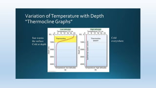
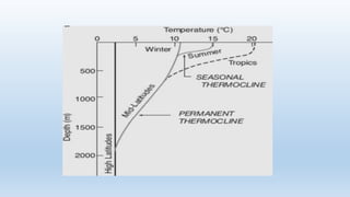
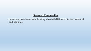
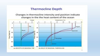
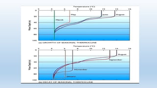
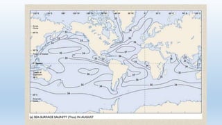
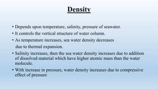
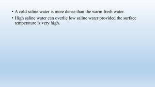
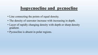
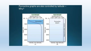
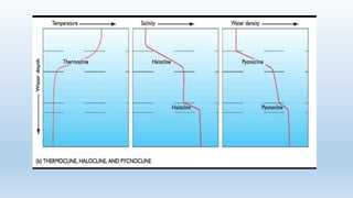
Oceanography
Thermocline, halocline, Pycnocline with quiz
By
Dr. Pramod Kumar Anthwal
Physicochemical structure of the oceans
• 1. Temperature-
• Isotherms- these are imaginary lines connecting the points of equal
temperature running
east west parallel to latitude
• Insolation- amount of solar radiation received by the Earth surface.
• Latitude controls the distribution of temperature through
insolation and it is also subject to variability with respect to
seasons.
• Because temperature is variable with respect to seasons and latitude,
• Isotherms shifts are significant in North Pacific and North
Atlantic ocean.
Thermocline
• When two water masses are separated from each other by a band of
water which have A Sharp temperature gradient.
• Or when temperature changes rapidly with depth.
• Thermocline is a permanent hydrographic feature of temperate
and tropical oceans
Seasonal Thermocline
• Forms due to intense solar heating about 40-100 meter in the oceans of
mid latitudes.
Salinity
• Function of latitudes and directly depends upon the latitude.
• Highest salinity value occur between 20 and 30° North and South
latitude and decrease towards equator and poles.
• Maximum salinity values occur in subtropics whereas minimum
values occur near the equator and the polar regions
Halocline
• Layer of rapidly changing salinity which separate two distinct water
masses.
• Indicates sharp salinity gradient existence.
Density
• Depends upon temperature, salinity, pressure of seawater.
• It controls the vertical structure of water column.
• As temperature increases, sea water density decreases
due to thermal expansion.
• Salinity increases, then the sea water density increases due to addition
of dissolved material which have higher atomic mass than the water
molecule.
• With increase in pressure, water density increases due to compressive
effect of pressure
• A cold saline water is more dense than the warm fresh water.
• High saline water can overlie low saline water provided the surface
temperature is very high.
Isopycnocline and pycnocline
• Line connecting the points of equal density.
• The density of seawater increase with increasing in depth.
• Layer of rapidly changing density with depth or sharp density
gradient.
• Pycnocline is absent in polar regions.
Density stratification causes 3 layer structure
of water column in ocean
1. Surface water- It is about 100 meter thick, 2% of the ocean volume
and dense ,
• Warm temperature diurnal seasonal annual fluctuation of salinity and,
• Water temperature in polar region, is too low, cooling of surface water
produce dense water, that will sink, which prevents the formation of
pynocline in high latitudes.
• Pycnocline layer- Boundary between surface layer and deep layer.
• Density gradient exist
• It is also known as thermocline layer because temperature also control
density.
• It contains 18% of ocean water by volume.
• In mid latitudes pycnocline coincide with thermocline.
• Deep layer:-
• 80% of oceanic water by volume
• The bulk of this layer originates from high latitudes.
• Water sink to the ocean bottom and then flows equator ward
preventing the formation of pycnocline in high latitudes.
Quiz
• Q1. The word subtropics is used to indicate which number of
latitude....
• Q2. The shifting of isotherms is significant in which oceans.
• Q3. Thermocline is considered as a permanent feature............
• Q4.in low latitude thermocline is - ------and in high latitude
thermocline is……..
• Q5. The seasonal thermocline is found in oceans of..............
• Q6. The typical depth of seasonal thermocline is...........
• 07 The maximum salinity value occur in between...............
• Isopycnocline line is………
• Typical depth of thermocline and pycnocline is……
• The average salinity of sea water is………..

Oceanography thermocline.pptx PRESENTED BY Dr. PK Anthwal

  • 1.
    Oceanography Thermocline, halocline, Pycnoclinewith quiz By Dr. Pramod Kumar Anthwal
  • 2.
    Physicochemical structure ofthe oceans • 1. Temperature- • Isotherms- these are imaginary lines connecting the points of equal temperature running east west parallel to latitude • Insolation- amount of solar radiation received by the Earth surface. • Latitude controls the distribution of temperature through insolation and it is also subject to variability with respect to seasons. • Because temperature is variable with respect to seasons and latitude, • Isotherms shifts are significant in North Pacific and North Atlantic ocean.
  • 3.
    Thermocline • When twowater masses are separated from each other by a band of water which have A Sharp temperature gradient. • Or when temperature changes rapidly with depth. • Thermocline is a permanent hydrographic feature of temperate and tropical oceans
  • 6.
    Seasonal Thermocline • Formsdue to intense solar heating about 40-100 meter in the oceans of mid latitudes.
  • 9.
    Salinity • Function oflatitudes and directly depends upon the latitude. • Highest salinity value occur between 20 and 30° North and South latitude and decrease towards equator and poles. • Maximum salinity values occur in subtropics whereas minimum values occur near the equator and the polar regions
  • 10.
    Halocline • Layer ofrapidly changing salinity which separate two distinct water masses. • Indicates sharp salinity gradient existence.
  • 14.
    Density • Depends upontemperature, salinity, pressure of seawater. • It controls the vertical structure of water column. • As temperature increases, sea water density decreases due to thermal expansion. • Salinity increases, then the sea water density increases due to addition of dissolved material which have higher atomic mass than the water molecule. • With increase in pressure, water density increases due to compressive effect of pressure
  • 15.
    • A coldsaline water is more dense than the warm fresh water. • High saline water can overlie low saline water provided the surface temperature is very high.
  • 16.
    Isopycnocline and pycnocline •Line connecting the points of equal density. • The density of seawater increase with increasing in depth. • Layer of rapidly changing density with depth or sharp density gradient. • Pycnocline is absent in polar regions.
  • 18.
    Density stratification causes3 layer structure of water column in ocean 1. Surface water- It is about 100 meter thick, 2% of the ocean volume and dense , • Warm temperature diurnal seasonal annual fluctuation of salinity and, • Water temperature in polar region, is too low, cooling of surface water produce dense water, that will sink, which prevents the formation of pynocline in high latitudes.
  • 19.
    • Pycnocline layer-Boundary between surface layer and deep layer. • Density gradient exist • It is also known as thermocline layer because temperature also control density. • It contains 18% of ocean water by volume. • In mid latitudes pycnocline coincide with thermocline.
  • 20.
    • Deep layer:- •80% of oceanic water by volume • The bulk of this layer originates from high latitudes. • Water sink to the ocean bottom and then flows equator ward preventing the formation of pycnocline in high latitudes.
  • 22.
    Quiz • Q1. Theword subtropics is used to indicate which number of latitude.... • Q2. The shifting of isotherms is significant in which oceans. • Q3. Thermocline is considered as a permanent feature............ • Q4.in low latitude thermocline is - ------and in high latitude thermocline is…….. • Q5. The seasonal thermocline is found in oceans of.............. • Q6. The typical depth of seasonal thermocline is........... • 07 The maximum salinity value occur in between...............
  • 23.
    • Isopycnocline lineis……… • Typical depth of thermocline and pycnocline is…… • The average salinity of sea water is………..