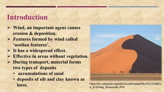
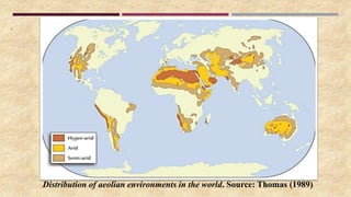
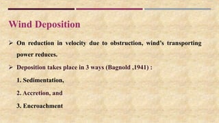
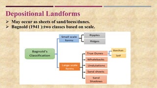
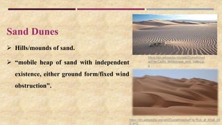
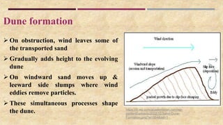
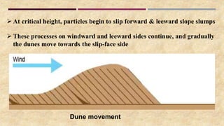
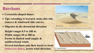
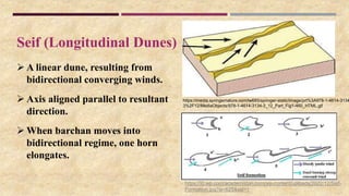
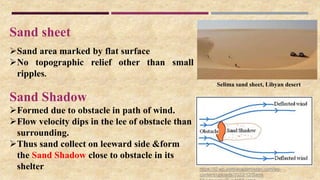
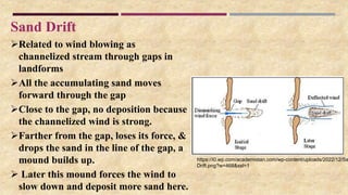
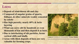
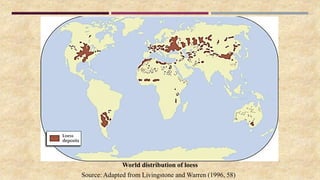
Department of Applied Geology
Dr. HariSingh Gour Vishwavidyalaya
Sagar, Madhya Pradesh
Depositional Features of Aeolian Cycle
Abhishek Kumar
M.Tech 1st Sem
Reg. No. Y22251018
Under Guidance of:
Prof. P.K. Kathal
Seminar
Contents
 Introduction
 Aeolian Environments of Deposition
 Deposition
 Landforms
• Sand Dunes
• Sheets of Sand
• Loess
Introduction
 Wind, an important agent causes
erosion & deposition.
 Features formed by wind called
‘aeolian features’.
 It has a widespread effect.
 Effective in areas without vegetation.
 During transport, material forms
two types of deposits
• accumulations of sand
• deposits of silt and clay known as
loess. https://en.wikipedia.org/wiki/Dune#/media/File:D%C3%BCn
e_S-Schlag_Sossusvlei.JPG
Environments
 Non-desertic:
(a) along shore lines
(b) along stream courses in semi-arid regions
(c) areas with poorly consolidated sediments (sand grains)
(d) areas of glacial outwash.
 Arid, semi-arid & sub-humid regions show best development
 Such regions generally occur in central & western regions of
continents in northern hemisphere.
.
Distribution of aeolian environments in the world. Source: Thomas (1989)
Wind Deposition
 On reduction in velocity due to obstruction, wind’s transporting
power reduces.
 Deposition takes place in 3 ways (Bagnold ,1941) :
1. Sedimentation,
2. Accretion, and
3. Encroachment
Depositional Landforms
 May occur as sheets of sand/loess/dunes.
 Bagnold (1941 ):two classes based on scale.
Sand Dunes
 Hills/mounds of sand.
 “mobile heap of sand with independent
existence, either ground form/fixed wind
obstruction”.
https://en.wikipedia.org/wiki/Dune#/media/File:Rub_al_Khali_00
2.JPG
https://en.wikipedia.org/wiki/Dune#/med
ia/File:Cadiz_Wilderness_and_Valley.jp
g
Dune formation
 On obstruction, wind leaves some of
the transported sand
 Gradually adds height to the evolving
dune
 On windward sand moves up &
leeward side slumps where wind
eddies remove particles.
 These simultaneous processes shape
the dune. https://i0.wp.com/academistan.com/wp-
content/uploads/2022/12/Sand-Dune-
Formation.png?w=564&ssl=1
 At critical height, particles begin to slip forward & leeward slope slumps
 These processes on windward and leeward sides continue, and gradually
the dunes move towards the slip-face side
Dune movement
Barchans
 Crescentic-shaped dunes.
 Tips extending to leeward, make this side
concave & windward side convex.
 Migrates in the downwind direction
 Height ranges 0.5 to 100 m.
 Width ranges 30 to 300 m.
 Forms in limited sand supply &
unidirectional winds.
 Several barchans join their horns to form
transverse dunes, across wind direction.
https://en.wikipedia.org/wiki/Barchan#/media/File:Barchan.jpg
https://en.wikipedia.org/wiki/Dune#/media/File:Tranverse_dune.jpg
Seif (Longitudinal Dunes)
 A linear dune, resulting from
bidirectional converging winds.
 Axis aligned parallel to resultant
direction.
 When barchan moves into
bidirectional regime, one horn
elongates.
https://media.springernature.com/lw685/springer-static/image/prt%3A978-1-4614-3134
3%2F12/MediaObjects/978-1-4614-3134-3_12_Part_Fig1-460_HTML.gif
https://i0.wp.com/academistan.com/wp-content/uploads/2022/12/Seif-
Formation.jpg?w=625&ssl=1
Parabolic Dunes
 An inversion of barchans
 Horns point windwards
 Typical in moist regions
 Elongated arms held in place by
vegetation
 Formed from blowout dunes
where the erosion of vegetated
sand leads to a U-shaped
depression.
https://upload.wikimedia.org/wikipedia/commons/0/09/P
arabolic_dune.jpg
Star Dunes
 Sand mounds with slip faces on 3/more arms
 Radiate from high center of the mound
 Formed in multi-directional wind regime
 Grow upward rather than laterally
 Fixed at one site for years
Sand Ripples
 Small scale, regular, wave-like undulations
 Perpendicular to wind direction
 1 to 30 cm high & few cm to some m apart
 Shape changes very quickly Sand ripples
Star dunes
https://en.wikipedia.org/wiki/Ripple_marks#/me
dia/File:1969_Afghanistan_(Sistan)_wind_rippl
Adapted from McKee (1979)
 Long, undulating features
 Saltation is main process of their formation.
 Particles on leeward side protected from wind
impact
 Crest receives grains faster than it loses them
 Depressions lose grains faster than they receive &
hence get hollowed
Whalebacks
 Flat-topped sand ridge extending parallel to wind
 Bagnold: residue from the series of dune chains
downwind
 larger dimensions, may be 100 miles long, 2 miles
wide, & 150 feet high.
Sand Ridges
Sand ridge
https://i0.wp.com/academistan.com/wp-content/uploads/2022/12/
ridge.png?w=469&ssl=1
Dunefields
Accumulations of sand
Occupying areas < 30,000 km2 with at least 10 dunes spaced
at distances exceeding dune wavelength
Contain small and simple dunes.
Chains of transverse & seif dunes, barchans & other features
develop on whalebacks to make dune fields.
Sand seas
 Differ from dunefields in areas >30,000 km2
 Bears more complex & bigger dunes.
 Ridges or mounds repeated in rows, giving wavy appearance.
 About 60% of sand seas are dune-covered,
 others may be dune-free and comprise low sand sheets, with
some vegetation
https://geography.name/wp-
content/uploads/2015/09/1-camel-caravan-in-the-
erg-chebbi-southern-morocco-ralph-ledergerber-
640x319.jpg
https://i0.wp.com/academistan.com/wp-
content/uploads/2022/12/Dunefield.jpg?re
size=304%2C228&ssl=1
Sand sheet
Sand area marked by flat surface
No topographic relief other than small
ripples.
Sand Shadow
Formed due to obstacle in path of wind.
Flow velocity dips in the lee of obstacle than
surrounding.
Thus sand collect on leeward side &form
the Sand Shadow close to obstacle in its
shelter
Selima sand sheet, Libyan desert
https://i0.wp.com/academistan.com/wp-
content/uploads/2022/12/Sand-
Sand Drift
Related to wind blowing as
channelized stream through gaps in
landforms
All the accumulating sand moves
forward through the gap
Close to the gap, no deposition because
the channelized wind is strong.
Farther from the gap, loses its force, &
drops the sand in the line of the gap, a
mound builds up.
 Later this mound forces the wind to
slow down and deposit more sand here.
https://i0.wp.com/academistan.com/wp-content/uploads/2022/12/Sa
Drift.png?w=468&ssl=1
Loess
Deposit of wind-blown silt and clay
Composed of angular grains of quartz,
feldspar, & other minerals weakly cemented
by calcite
Has high porosity, nearly 60% & lacks
layering
Wind can carry silt for hundreds or even
thousands of km and then deposit it as loess.
Due to interlocking of silt particles, forms
vertical cliffs and bluffs.
Areas with thick deposits of loess are very
valuable for farming crops.
https://en.wikipedia.org/wiki/Loess#/media/File:LoessVicksbur
Loess in Vicksburg, Mississippi, United States
World distribution of loess
Source: Adapted from Livingstone and Warren (1996, 58)
References
https://academistan.com/geography/geomorphology/aeolian-landforms-erosional-and-
depositional/
https://courses.lumenlearning.com/earthscienceck12/chapter/wind-erosion-and-deposition/
https://en.wikipedia.org/wiki/Aeolian_processes
Huggett, R.J. (2011). Fundamentals of Geomorphology 3rd Edition. London & New York:
Routledge, Taylor & Francis Group
Plummer, Charles C., Carlson, Diane H. & Hammersley, Lisa (2016). Physical Geology. Mc
Graw Hill Education
Summerfield, M. A. (2013). Global Geomorphology. London & New York: Routledge, Taylor
& Francis Group
Thornbury, W. D. (1954). Principles of Geomorphology. New York: John Wiley & Sons, Inc.,
London: Chapman & Hall, Ltd.
Thank you

Aeolian Deposition.pptx

  • 1.
    Department of AppliedGeology Dr. HariSingh Gour Vishwavidyalaya Sagar, Madhya Pradesh Depositional Features of Aeolian Cycle Abhishek Kumar M.Tech 1st Sem Reg. No. Y22251018 Under Guidance of: Prof. P.K. Kathal Seminar
  • 2.
    Contents  Introduction  AeolianEnvironments of Deposition  Deposition  Landforms • Sand Dunes • Sheets of Sand • Loess
  • 3.
    Introduction  Wind, animportant agent causes erosion & deposition.  Features formed by wind called ‘aeolian features’.  It has a widespread effect.  Effective in areas without vegetation.  During transport, material forms two types of deposits • accumulations of sand • deposits of silt and clay known as loess. https://en.wikipedia.org/wiki/Dune#/media/File:D%C3%BCn e_S-Schlag_Sossusvlei.JPG
  • 4.
    Environments  Non-desertic: (a) alongshore lines (b) along stream courses in semi-arid regions (c) areas with poorly consolidated sediments (sand grains) (d) areas of glacial outwash.  Arid, semi-arid & sub-humid regions show best development  Such regions generally occur in central & western regions of continents in northern hemisphere.
  • 5.
    . Distribution of aeolianenvironments in the world. Source: Thomas (1989)
  • 6.
    Wind Deposition  Onreduction in velocity due to obstruction, wind’s transporting power reduces.  Deposition takes place in 3 ways (Bagnold ,1941) : 1. Sedimentation, 2. Accretion, and 3. Encroachment
  • 7.
    Depositional Landforms  Mayoccur as sheets of sand/loess/dunes.  Bagnold (1941 ):two classes based on scale.
  • 8.
    Sand Dunes  Hills/moundsof sand.  “mobile heap of sand with independent existence, either ground form/fixed wind obstruction”. https://en.wikipedia.org/wiki/Dune#/media/File:Rub_al_Khali_00 2.JPG https://en.wikipedia.org/wiki/Dune#/med ia/File:Cadiz_Wilderness_and_Valley.jp g
  • 9.
    Dune formation  Onobstruction, wind leaves some of the transported sand  Gradually adds height to the evolving dune  On windward sand moves up & leeward side slumps where wind eddies remove particles.  These simultaneous processes shape the dune. https://i0.wp.com/academistan.com/wp- content/uploads/2022/12/Sand-Dune- Formation.png?w=564&ssl=1
  • 10.
     At criticalheight, particles begin to slip forward & leeward slope slumps  These processes on windward and leeward sides continue, and gradually the dunes move towards the slip-face side Dune movement
  • 11.
    Barchans  Crescentic-shaped dunes. Tips extending to leeward, make this side concave & windward side convex.  Migrates in the downwind direction  Height ranges 0.5 to 100 m.  Width ranges 30 to 300 m.  Forms in limited sand supply & unidirectional winds.  Several barchans join their horns to form transverse dunes, across wind direction. https://en.wikipedia.org/wiki/Barchan#/media/File:Barchan.jpg https://en.wikipedia.org/wiki/Dune#/media/File:Tranverse_dune.jpg
  • 12.
    Seif (Longitudinal Dunes) A linear dune, resulting from bidirectional converging winds.  Axis aligned parallel to resultant direction.  When barchan moves into bidirectional regime, one horn elongates. https://media.springernature.com/lw685/springer-static/image/prt%3A978-1-4614-3134 3%2F12/MediaObjects/978-1-4614-3134-3_12_Part_Fig1-460_HTML.gif https://i0.wp.com/academistan.com/wp-content/uploads/2022/12/Seif- Formation.jpg?w=625&ssl=1
  • 13.
    Parabolic Dunes  Aninversion of barchans  Horns point windwards  Typical in moist regions  Elongated arms held in place by vegetation  Formed from blowout dunes where the erosion of vegetated sand leads to a U-shaped depression. https://upload.wikimedia.org/wikipedia/commons/0/09/P arabolic_dune.jpg
  • 14.
    Star Dunes  Sandmounds with slip faces on 3/more arms  Radiate from high center of the mound  Formed in multi-directional wind regime  Grow upward rather than laterally  Fixed at one site for years Sand Ripples  Small scale, regular, wave-like undulations  Perpendicular to wind direction  1 to 30 cm high & few cm to some m apart  Shape changes very quickly Sand ripples Star dunes https://en.wikipedia.org/wiki/Ripple_marks#/me dia/File:1969_Afghanistan_(Sistan)_wind_rippl Adapted from McKee (1979)
  • 15.
     Long, undulatingfeatures  Saltation is main process of their formation.  Particles on leeward side protected from wind impact  Crest receives grains faster than it loses them  Depressions lose grains faster than they receive & hence get hollowed Whalebacks  Flat-topped sand ridge extending parallel to wind  Bagnold: residue from the series of dune chains downwind  larger dimensions, may be 100 miles long, 2 miles wide, & 150 feet high. Sand Ridges Sand ridge https://i0.wp.com/academistan.com/wp-content/uploads/2022/12/ ridge.png?w=469&ssl=1
  • 16.
    Dunefields Accumulations of sand Occupyingareas < 30,000 km2 with at least 10 dunes spaced at distances exceeding dune wavelength Contain small and simple dunes. Chains of transverse & seif dunes, barchans & other features develop on whalebacks to make dune fields. Sand seas  Differ from dunefields in areas >30,000 km2  Bears more complex & bigger dunes.  Ridges or mounds repeated in rows, giving wavy appearance.  About 60% of sand seas are dune-covered,  others may be dune-free and comprise low sand sheets, with some vegetation https://geography.name/wp- content/uploads/2015/09/1-camel-caravan-in-the- erg-chebbi-southern-morocco-ralph-ledergerber- 640x319.jpg https://i0.wp.com/academistan.com/wp- content/uploads/2022/12/Dunefield.jpg?re size=304%2C228&ssl=1
  • 17.
    Sand sheet Sand areamarked by flat surface No topographic relief other than small ripples. Sand Shadow Formed due to obstacle in path of wind. Flow velocity dips in the lee of obstacle than surrounding. Thus sand collect on leeward side &form the Sand Shadow close to obstacle in its shelter Selima sand sheet, Libyan desert https://i0.wp.com/academistan.com/wp- content/uploads/2022/12/Sand-
  • 18.
    Sand Drift Related towind blowing as channelized stream through gaps in landforms All the accumulating sand moves forward through the gap Close to the gap, no deposition because the channelized wind is strong. Farther from the gap, loses its force, & drops the sand in the line of the gap, a mound builds up.  Later this mound forces the wind to slow down and deposit more sand here. https://i0.wp.com/academistan.com/wp-content/uploads/2022/12/Sa Drift.png?w=468&ssl=1
  • 19.
    Loess Deposit of wind-blownsilt and clay Composed of angular grains of quartz, feldspar, & other minerals weakly cemented by calcite Has high porosity, nearly 60% & lacks layering Wind can carry silt for hundreds or even thousands of km and then deposit it as loess. Due to interlocking of silt particles, forms vertical cliffs and bluffs. Areas with thick deposits of loess are very valuable for farming crops. https://en.wikipedia.org/wiki/Loess#/media/File:LoessVicksbur Loess in Vicksburg, Mississippi, United States
  • 20.
    World distribution ofloess Source: Adapted from Livingstone and Warren (1996, 58)
  • 21.
    References https://academistan.com/geography/geomorphology/aeolian-landforms-erosional-and- depositional/ https://courses.lumenlearning.com/earthscienceck12/chapter/wind-erosion-and-deposition/ https://en.wikipedia.org/wiki/Aeolian_processes Huggett, R.J. (2011).Fundamentals of Geomorphology 3rd Edition. London & New York: Routledge, Taylor & Francis Group Plummer, Charles C., Carlson, Diane H. & Hammersley, Lisa (2016). Physical Geology. Mc Graw Hill Education Summerfield, M. A. (2013). Global Geomorphology. London & New York: Routledge, Taylor & Francis Group Thornbury, W. D. (1954). Principles of Geomorphology. New York: John Wiley & Sons, Inc., London: Chapman & Hall, Ltd.
  • 22.