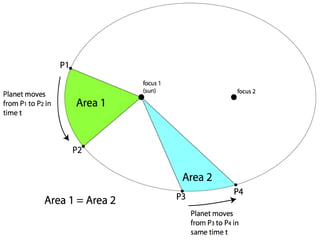
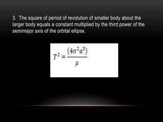
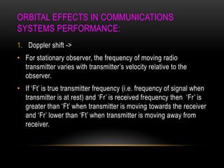
1. Kepler's laws of planetary motion describe the motion of planets and satellites in orbit. The orbital period is determined by the semimajor axis of the elliptical orbit.
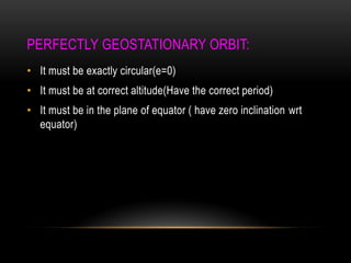
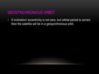
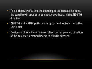
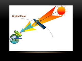
2. A geostationary orbit is circular, at an altitude that matches the orbital period to Earth's sidereal day, and in the equatorial plane. A geosynchronous orbit has the correct period but may have eccentricity or inclination.
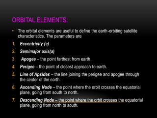
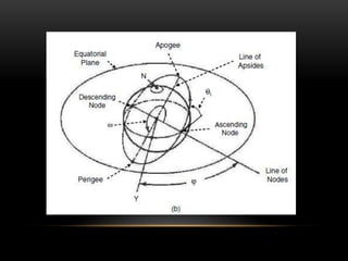
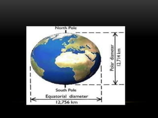
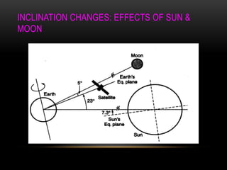
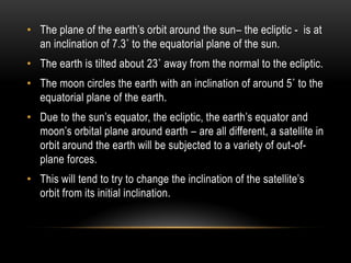
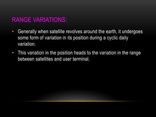
3. Orbital elements like eccentricity, semimajor axis, inclination and nodes define the characteristics of Earth-orbiting satellites. Perturbations from factors like the Sun and Moon cause the orbital elements and position to change over time.
Attitude & orbital control system, TTC & M system, Power system, Communication subsystem, Satellite antenna, Space qualification, Equipment Reliability, redundancy
Satellite Link Design:
EIRP, Transmission Losses, Free-space transmission, System noise temperature and G/T ratio, Noise figure, Design of downlinks, Design of uplink, Design of specified C/N: combining C/N and C/I values in satellite links, Overall C/No, Link design procedure.
Satellite Link Design:
EIRP, Transmission Losses, Free-space transmission, System noise temperature and G/T ratio, Noise figure, Design of downlinks, Design of uplink, Design of specified C/N: combining C/N and C/I values in satellite links, Overall C/No, Link design procedure.
Contact: Facebook URL: fb.com/sajidhasanrawnak
This Slides will answer the following Questions-
What is Orbit?
Different types of orbit used in Satellite System? Explain each of them in brief.
Familiarization of different orbital parameters defining the satellite orbit with detail description.
Basic principles of orbiting satellites - Kepler’s Laws
What is eccentricity? How it is characterized the shape of an orbit?
What is orbital period? Derivation of orbital period. Explain how eccentricity and flattening plays a vital role to visualized the shape of earth?
What is Injection Velocity? How it affects the Resulting Satellite Trajectories?
Conditions required to become a geostationary satellite?
Slant Range.
Line-of-sight distance between two satellites.
Geodetic Astronomy - MOTION IN THE HEAVENS - EARTH, SUN AND STARSAhmed Nassar
Geodetic Astronomy
MOTION IN THE HEAVENS
EARTH, SUN AND STARS
Motion of Earth
Earth’s Rotation
Earth’s Revolution
Motion of Sun
Equinoxes
Solstices
Motion of Stars
Proper Motion
Transverse Velocity
Radial Velocity
Overview
WLAN Technologies - Infrared LANs, Spread Spectrum LANs, Narrowband Microwave LANs
IEEE 802.11 – Architecture, protocols, MAC layer, MAC Frame, MAC Management
Infra Red
Global system for mobile communication Introduction, GSM architecture, GSM interfaces, Signal processing in GSM,
Frame structure of GSM, Channels used in GSM
Frequencies management,Channel assignments,
Frequency reuse, System capacity and its improvement: Cell spliting and sectoring, Handoffs & its types, prioritizing handoff, Umbrella cell approach, Cell dragging, Roaming, Co channel and adjacent channel interference, Improving coverage- Repeaters for range extension and microcell zone concept, Examples
History, Basic concepts of wireless communication, challenges in wireless communication, cellular communication, performance criteria, wireless communication standars, how call is made?
Explore the innovative world of trenchless pipe repair with our comprehensive guide, "The Benefits and Techniques of Trenchless Pipe Repair." This document delves into the modern methods of repairing underground pipes without the need for extensive excavation, highlighting the numerous advantages and the latest techniques used in the industry.
Learn about the cost savings, reduced environmental impact, and minimal disruption associated with trenchless technology. Discover detailed explanations of popular techniques such as pipe bursting, cured-in-place pipe (CIPP) lining, and directional drilling. Understand how these methods can be applied to various types of infrastructure, from residential plumbing to large-scale municipal systems.
Ideal for homeowners, contractors, engineers, and anyone interested in modern plumbing solutions, this guide provides valuable insights into why trenchless pipe repair is becoming the preferred choice for pipe rehabilitation. Stay informed about the latest advancements and best practices in the field.
Welcome to WIPAC Monthly the magazine brought to you by the LinkedIn Group Water Industry Process Automation & Control.
In this month's edition, along with this month's industry news to celebrate the 13 years since the group was created we have articles including
A case study of the used of Advanced Process Control at the Wastewater Treatment works at Lleida in Spain
A look back on an article on smart wastewater networks in order to see how the industry has measured up in the interim around the adoption of Digital Transformation in the Water Industry.
Sachpazis:Terzaghi Bearing Capacity Estimation in simple terms with Calculati...Dr.Costas Sachpazis
Terzaghi's soil bearing capacity theory, developed by Karl Terzaghi, is a fundamental principle in geotechnical engineering used to determine the bearing capacity of shallow foundations. This theory provides a method to calculate the ultimate bearing capacity of soil, which is the maximum load per unit area that the soil can support without undergoing shear failure. The Calculation HTML Code included.
Cosmetic shop management system project report.pdfKamal Acharya
Buying new cosmetic products is difficult. It can even be scary for those who have sensitive skin and are prone to skin trouble. The information needed to alleviate this problem is on the back of each product, but it's thought to interpret those ingredient lists unless you have a background in chemistry.
Instead of buying and hoping for the best, we can use data science to help us predict which products may be good fits for us. It includes various function programs to do the above mentioned tasks.
Data file handling has been effectively used in the program.
The automated cosmetic shop management system should deal with the automation of general workflow and administration process of the shop. The main processes of the system focus on customer's request where the system is able to search the most appropriate products and deliver it to the customers. It should help the employees to quickly identify the list of cosmetic product that have reached the minimum quantity and also keep a track of expired date for each cosmetic product. It should help the employees to find the rack number in which the product is placed.It is also Faster and more efficient way.
Industrial Training at Shahjalal Fertilizer Company Limited (SFCL)MdTanvirMahtab2
This presentation is about the working procedure of Shahjalal Fertilizer Company Limited (SFCL). A Govt. owned Company of Bangladesh Chemical Industries Corporation under Ministry of Industries.
2. KEPLER‟S LAW OF PLANETARY MOTION:
1. The orbit of any smaller body about a larger body is always an
ellipse, with center of mass of the larger body as one of the two
foci.
2. The orbit of the smaller body sweeps out equal areas in equal
time.
3.
4.
5. 3. The square of period of revolution of smaller body about the
larger body equals a constant multiplied by the third power of the
semimajor axis of the orbital ellipse.
6. • This equation determines period of any satellite.
• It is used in every GPS receiver in calculation of positions of
GPS satellites.
7. PERFECTLY GEOSTATIONARY ORBIT:
• It must be exactly circular(e=0)
• It must be at correct altitude(Have the correct period)
• It must be in the plane of equator ( have zero inclination wrt
equator)
8. GEOSYNCHRONOUS ORBIT:
• If inclination/ eccentricity is not zero, but orbital period is correct
then the satellite will be in a geosynchronous orbit.
9.
10. • Apogee-> The point in the orbit where the satellite is farthest
from the earth is called apogee.
• Perigee-> The point in the orbit where the satellite is closest to
earth is called perigee.
• The perigee and apogee are always opposite to each other.
• The orbital period of a GEO satellite, 23 h 56 min 4.1s, is one
sidereal day.
• Solar day is 3.94 min longer than a sidereal day which is 24h.
11. LOOK ANGLE DETERMINATION:
• Surface of the earth is divided up into a grid like structure :
Latitude and Longitude.
• Latitude is the angular distance , measured in degrees, north to
south.
• Longitude is the angular distance, measured in degrees, from a
given reference longitudinal line.
• E.g. Latitude 90 degree N(=90 degree)
12.
13. • The coordinates to which an earth station antenna must be
pointed to communicate with a satellite are called LOOK
ANGLES.
• Look angles commonly expressed as azimuth(Az) and
elevation(El).
• Azimuth(Az) is measured eastward (clockwise) from geographic
north to the projection of satellite path on horizontal plane at
earth station.
• Elevation is the angle measured upward from the local
horizontal plane at earth station to satellite path.
14.
15. THE SUBSATELLITE POINT:
• The subsatellite point is the location on the surface of the earth
that lies directly between the satellite and center of the earth.
• It is the NADIR pointing direction from the satellite.
• For satellite in an equatorial orbit , it will always be located on
the equator.
16.
17. • To an observer of a satellite standing at the subsatellite point,
the satellite will appear to be directly overhead, in the ZENITH
direction.
• ZENITH and NADIR paths are in opposite directions along the
same path.
• Designers of satellite antennas reference the pointing direction
of the satellite‟s antenna beams to NADIR direction.
18. ORBITAL ELEMENTS:
• The orbital elements are useful to define the earth-orbiting satellite
characteristics. The parameters are
1. Eccentricity (e)
2. Semimajor axis(a)
3. Apogee – the point farthest from earth.
4. Perigee – the point of closest approach to earth.
5. Line of Apsides – the line joining the perigee and apogee through
the center of the earth.
6. Ascending Node – the point where the orbit crosses the equatorial
plane, going from south to north.
7. Descending Node – the point where the orbit crosses the equatorial
plane, going from north to south.
19.
20. • Line of Nodes – the line joining the ascending and descending
nodes through the center of the earth.
• Inclination (i) -
• Right ascension of ascending node (Ω) – It is the angle
measured between line connecting center of earth to ascending
node & another line from center of the earth to an inertial point
in the space.
• Argument of perigee (w)- The angle between the ascending
node to perigee.
21. ORBITAL PERTURBATIONS:
• Under ideal conditions, we consider the orbit as an ellipse
whose properties are constant with time.
• In practice, the satellite and the earth respond to many other
influences including asymmetry of earth‟s gravitational field, the
gravitational fields of sun and moon, and solar radiation
pressure.
• For LEO satellites, atmospheric drag can also be important.
• All of these interfering forces cause the true orbit to be different
from ellipse.
• The perturbations are assumed to cause the orbital elements to
vary with time.
22. LONGITUDINAL CHANGES: EFFECTS OF EARTH‟S
OBLATNESS:
• The earth is neither a perfect sphere nor a perfect ellipse.
• The earth is flattened at the poles; the equatorial diameter is
about 20 km more than average polar diameter.
• The equatorial radius is not constant (does not vary more than
100m around equator)
• There are some regions on earth where the gravitational
attraction is higher, referred as regions of mass concentration or
MASCONS.
• These nonregular features of the earth lead to nonuniform
gravitational field around earth. The force on an orbiting satellite
will vary with position.
23.
24. • A GEO satellite is weightless when it is in orbit. The smallest
force on satellite will cause it to accelerate and then drift away
from its nominal location.
• There will generally be an additional force toward the nearest
equatorial bulge in either an eastward or westward direction
along orbital plane.
25. • Due to position of Mascons & equatorial bulges, there are four
equilibrium points in the geostationary orbit: two stable and two
unstable.
• Stable points-> 75˚ E and 252˚ E
• Unstable points-> 162˚ E and 348˚ E
• The satellite at an unstable orbital location is at top of a gravity
hill. Given a small force, it will drift down the gravity slope into
gravity well(valley) and finally stay there, at the stable position.
• If a satellite is perturbed slightly from one of the stable points, it
will tend to drift back to the stable point without any thruster
firings required.
• If a satellite is perturbed slightly from one of the unstable points,
it will immediately begin to accelerate its drift toward nearer
stable point and once it reaches this point, it will oscillate in
longitudinal position about this point until it stabilizes at that
point.
26. • These stable points are called graveyard geosynchronous orbit
locations.
28. • The plane of the earth‟s orbit around the sun– the ecliptic - is at
an inclination of 7.3˚ to the equatorial plane of the sun.
• The earth is tilted about 23˚ away from the normal to the ecliptic.
• The moon circles the earth with an inclination of around 5˚ to the
equatorial plane of the earth.
• Due to the sun‟s equator, the ecliptic, the earth‟s equator and
moon‟s orbital plane around earth – are all different, a satellite in
orbit around the earth will be subjected to a variety of out-of-
plane forces.
• This will tend to try to change the inclination of the satellite‟s
orbit from its initial inclination.
29. • The mass of sun is significantly larger than that of the moon but
the moon is considerably closer to the earth than the sun.
• For this reason, the acceleration force induced by the moon on
a geostationary satellite is about twice as large as that of the
sun.
• The net effect of the acceleration forces induced by the moon
and sun on a geostationary satellite is to change the plane of
the orbit at an initial average rate of change of 0.85˚/year from
the equatorial plane.
• When both the sun and moon are acting on the same side of
satellite‟s orbit, the rate of change of plane of geostationary
satellite‟s orbit will be higher than average.
• When both the sun and moon are acting on the opposite side of
satellite‟s orbit, the rate of change of plane of geostationary
satellite‟s orbit will be less than average.
30. • To increase the orbital maneuver lifetime of a satellite for a
given fuel load, mission planners deliberately place a satellite
planned for geostationary orbit into an initial orbit with an
inclination.
31. ORBIT DETERMINATION:
• Orbit determination requires that sufficient measurements be
made to determine uniquely the six orbital elements needed to
calculate the future orbit of the satellite.
• Hence calculate the required changes that need to be made to
the orbit to keep it within nominal orbital location.
• The control earth station use to measure the angular position of
the satellites.
• These earth station are generally referred to as TTC&M
(Telemetry, Tracking, Command and Monitoring) stations of the
satellite network.
32. • Major satellite networks maintain their own TTC&M stations
around the world.
• Smaller satellite systems generally contact for such TTC&M
functions from spacecraft manufacturer or from the large
satellite system operators, as it is generally uneconomic to build
advanced TTC&M stations with fewer than 3 satellites to control.
33. ORBITAL EFFECTS IN COMMUNICATIONS
SYSTEMS PERFORMANCE:
1. Doppler shift ->
• For stationary observer, the frequency of moving radio
transmitter varies with transmitter‟s velocity relative to the
observer.
• If „Ft‟ is true transmitter frequency (i.e. frequency of signal when
transmitter is at rest) and „Fr‟ is received frequency then „Fr‟ is
greater than „Ft‟ when transmitter is moving towards the receiver
and „Fr‟ lower than „Ft‟ when transmitter is moving away from
receiver.
34.
35. RANGE VARIATIONS:
• Generally when satellite revolves around the earth, it undergoes
some form of variation in its position during a cyclic daily
variation.
• This variation in the position heads to the variation in the range
between satellites and user terminal.
36. SOLAR ECLIPSE:
• A satellite is said to be in eclipse when the earth prevents
sunlight from reaching it, that is, when the satellite is in the
shadow of the earth.
• For geostationary satellites, eclipses occur during two periods
that begin 23 days before the equinoxes(March 21 & September
23) and end 23 days after equinox periods.
• Eclipse occur close to equinoxes, as these are the times when
the sun, the earth, and the satellite are all nearly in the same
plane.
37.
38. • During full eclipse, a satellite receives no power from its solar
array and it must operate entirely from its batteries.
• Batteries are designed to operate with a maximum depth of
discharge.
• Nickel-Hydrogen batteries, can operate at about 70% depth of
discharge and recover fully once recharged.
• Ground controllers perform battery-conditioning routines prior to
eclipse operation.
• The routines consist of deliberately discharging the batteries
until they are close to their maximum depth of discharge, and
then fully recharging the batteries before eclipse season begins.
39. • The eclipse season is design challenge for spacecraft builders.
• Rapidity with which the satellite enters and exits the shadow can
cause extreme changes in both power and heating effects over
relative short periods.
• Eclipse periods are therefore monitored carefully by ground
controllers, as this when most of the equipment failures are
likely to occur.
40. SUN TRANSIT OUTAGE:
• During the equinox periods, not only does the satellite pass
through the earth‟s shadow on the dark side of the earth, but the
orbit of the satellite will also pass directly in front of the sun.
• The sun is a “hot” microwave source with an equivalent
temperature of about 6000 to 10000k.
• The earth station antenna will therefore receive not only the
signal from the satellite but also the noise temperature
transmitted by sun.
41.
42. • For satellite system operators with more than one satellite at
their disposal, traffic can be off-loaded to satellites that are just
out of , or are yet to enter, a sun outage.
43. LAUNCH & LAUNCH VEHICLES:
• A Satellite cannot be placed into a stable orbit unless two
parameters that are uniquely coupled together – the velocity
vector and the orbit height – are simultaneously correct.
• A geo-stationary satellite, must be in orbit at a height of
35,786.03 km above the surface of the earth (42,164.17 km
radius from center of the earth) with an inclination of zero
degrees, an elliptically of zero, and a velocity of 3074.7 m/s
tangential to earth in the plane of the orbit, which is the earth‟s
equatorial plane.
• The further out from the earth orbit is, the greater the energy
required from launch vehicle to reach that orbit.
44. • In any earth satellite launch, the largest fraction of energy
expended by rocket is used to accelerate the vehicle from rest
until it is about 20 miles (32 Km) above the earth.
• To make the most efficient use of the fuel, it is common to shed
excess mass from launcher as it moves upward on launch; this
is called staging.
45. • Most launch vehicles have multiple stages and, as each stage is
completed, that portion of launcher is expended until final stage
places the satellite into desired trajectory. Hence the term:
Expendable Launch Vehicle (ELV).
• The Space Shuttle, called the Space Transportation System
(STS) by NASA, is partially reusable.
• The solid rocket boosters are recovered and refurbished for
future missions and the shuttle vehicle itself is flown back to
earth for refurbishment and reuse. Hence the term: Reusable
Launch Vehicle (RLV).
46. PLACING SATELLITE IN GEOSTATIONARY ORBIT:
• 1. GEOSTATIONARY TRANSFER ORBIT AND AKM