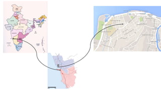
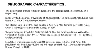
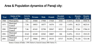
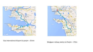
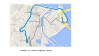
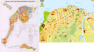
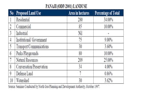
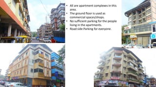
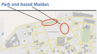
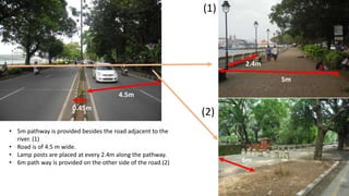
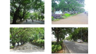
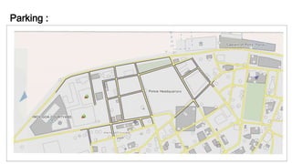
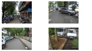
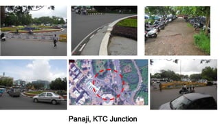
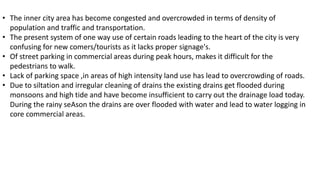
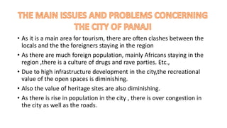
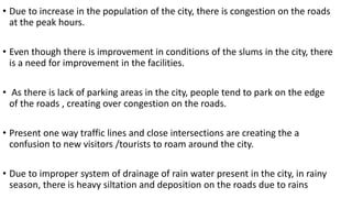
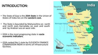
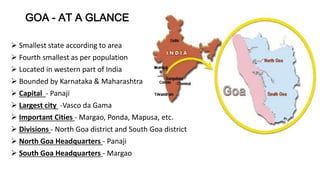
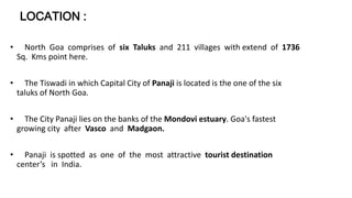
This document provides an overview of the city of Panaji, Goa, India. It discusses the city's location, climate, demographics, transportation infrastructure, and urban design challenges. Panaji has a tropical climate with high rainfall during the monsoon season. Its population is over 114,000, with a literacy rate of 71.6%. While the city has various modes of transportation, including an airport and ports, it struggles with traffic congestion and a lack of sufficient parking facilities. Preserving the city's cultural heritage and open spaces poses an ongoing challenge amid commercial development pressures.
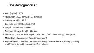
GROUP HOUSING : A DOMESTIC ARCHITECTURE ACCOMODATES THE GROUP RATHER THAN THE UNIT AND ITS THEREFORE PUBLIC AS WELL AS PRIVATE. IT IS FIMILIAR THROUGH THE WIDWSPREAD DEVELOPMENT OF MASS HOUSING IN THE WORLD IN WHICH INDIVIDUALS OR FAMILIES FIND LIVING SPACE EITHER IN M ULTIPLE DWELLINGS OR SINGLE LINITS PRODUCED IN QUALITY . GROUP HOUSING IS PRODUSED BY MANY KINDS OF CULTURES BY COMMUNAL STATES TO EQALIZE LIVING STANDDARDS BY TYRANTS TO ASSURE A DOCILE LABOUR FORCE, AND BY FEDUAL OR CASTE SYSTEM TO BRINGS TOGETHER MEMBERS OF A CLASS.
2. CLUSTER HOUSING
A SUBDIVISION TECHNIQUES WHERE KNOWN
AS ZERO –LOT –LINE HOUSING OR HIGH DENSITY
HOUSING DWELLING ARE GROUPED TOGHTHER
WITH COMMON AREA LEFT FOR RECREATION .
RAW HOUSING
ONE OF A SERIES OF HOUSES , OFTEN AS SIMILAR
OR IDENTICAL DESIGN, SITUATED SIDE BY SIDE
AND JOINED COMMON WALLS
3. PRADHAN MANTRI AWAS YOJANA
2 MILLION NON-SLUM URBAN POOR HOUSEHOLD
ARE PROPOSED TO BE COVERDED UNDER THE MISSION.
RAJIV AWAS YOJANA
IT UNCOURAGE “SLUM FREE INDIA” IN CITIES
IN WHICH EVERY CITIZEN HAS ACEES TO BASIC AMENITIES.
PRADHAN MANTRI GRAMIN AWAS YOZANA
PROVIDING FINANCIAL ASSISTANCE TO RURAL
POOR FOR CONSTRUCTING THEIR HOUSES THEMSELVES.
HOUSING FOR ALL BY 2022
MISSSION APPROVED A SUBSTANCIAL INCREAS IN INTEREST
RELIFE ON LOAN FOR THE URBAN POOR
TO PROMOTE AFFORDEBLE HOMES.
INTEREST SUBSIDY SCHEMES FOR HOUSING URBAN
THE SCHEMES ENVISAGES THE PROVISION OF
INTEREST TO EWS AND LIG SEGMENTS TO
ENABLES THEM TO BUY OR CONSTRUCT HOUSES.
4.Lower Income Group
Economic Weaker Section (EWS) means households with monthly household income upto Rs. 5000/- per month or as revised by the Ministry of Housing and Urban Poverty Alleviation, Government of India from time to time. Lower Income Group (LIG) means households with monthly household income between Rs. 5001/- to Rs.
5.Development of Group Housing will be under provision
of master plan, Enclave development plan and layout plan.
Minimum area of plot will be 2000sq.m
Land proposed for group housing will be located at 12m
wide exiting road, But the distance of the plot from 18m
(or above) wide road will not be more than 100m.
Slilt floor will be permitted for the purpose of parking in
group housing buildings, height of which of which be
2.1m up to the beam.
if slilt floor is used for purpose other than parking then
it will be counted in F.A.R.
Park and open area will be provided at the rate of
1.0sq.m. per person or 15% of the whole area,
whichever is more, in the plot of area 3000sq.m (or above).
study of famous housing projects by architect Charles Correa.
1. BELAPUR Housing
2. Kanchanjunga Apartments
3. Tarapur housing
Authors- Richa, Parveen n Aarti
INTRODUCTION
COORDINATES - 23.22 ON 72.680 E ELEVATION - 265 feet (81 m)*
LOCATED 23 KM NORTH OF AHEMDABAD (FIN CAP. OF GUJARAT)
PLANNED IN 1960S BY, PRAKASH M APTE & H. K. MEWADA,
AFTER PARTITION OF BOMBAY * STATE : AHEMDABAD WAS MADE AS THE CAPTAL OFGUJARAT
AREA TOTAL 177KM2 ELEVATION : 8IM ( 266 FT)
POPULATION (2011)
TOTAL: 206,167 DENSITY : 1,200/KM2
CLIMATE*
TROPICAL WET AND DRY CLIMATE•
SUMMER MAXIMUM - 36 to 42 °C MINIMUM - 19 to 27 C
WINTER MAXIMUM - 29 C MINIMUM - 14°C
MONSOON: THE AVERAGE ANNUAL RAINFALL IS AROUND 803.4 MM
LANGUAGES
GUJARATI, HINDI, AND ENGLISH• 54% GREEN COVER ON ITS LAND AREA
• THE CITY SITS ON THE BANKS OF THE SABARMATI RIVER, IN NORTH-CENTRALEAST GUJARAT
HISTORY
IN 1960, THE INDIAN STATE OF BOMBAY WAS SPLIT INTO TWO STATES, MAHARASHTRA AND GUJARAT LEAVING GUJARAT WITHOUT A CAPITAL CITY.
AT THE TIME AHMEDABAD WAS SELECTED TO BE THE FIRST CAPITAL OF THE NEWLY CREATED STATE.
• IT WAS LATER PROPOSED THAT A NEW CAPITAL CITY BE CONSTRUCTED FOR THE STATE.
• GANDHINAGAR GOT AN IDENTITY OF ITS OWN WHEN THE STATE OF MUMBAI WAS DIVIDED INTO TWO SEPARATE STATES OF GUJARAT AND MAHARASHTRA.
• IN THE BEGINNING, AHMEDABAD - A COMMERCIAL HUB OF GUJARAT WAS CHOSEN AS THE STATE CAPITAL AND IT WAS PROPOSED THAT A NEW CAPITAL SHOULD BE CONSTRUCTED ALONG THE LINE OF OTHER NEW STATE CAPITALS, PARTICULARLY CHANDIGARH
• THEREFORE TWO WELL-KNOWN INDIAN ARCHITECTS, H.K. MEWADA AND PRAKASH M. APTE (WHO WORKED AS BEGINNER FOR THE CHANDIGARH CITY) DESIGNED THE NEW STATE CAPITAL*
NAMED AFTER MAHATMA GANDHI THE FOUNDATION STONE OF THIS CITY WAS LAID ON 1965 AND IN 1971 THE CAPITAL WAS SHIFTED FROM AHMEDABAD TO GANDHINAGAR
PLANNING
• PLANNED AND IMPLEMENTED BETWEEN 1965-1970
• DETERMINATION TO MAKE GANDHINAGAR A PURELY INDIAN ENTERPRISE, PARTLY BECAUSE GUJARAT WAS THE BIRTHPLACE OF GANDHI.
• TO ESTABLISH AND MAINTAIN A SEPARATE IDENTITY FOR THE NEW CITY THE SURROUNDING AREA OF ABOUT 39 VILLAGES WAS BROUGHT UNDER A PERIPHERY CONTROL ACT (AS IN CHANDIGARH)
• THE AREA LATER CONSTITUTED A SEPARATE ADMINISTRATIVE DISTRICT OF GANDHINAGAR.
• THE CITY WAS PLANNED FOR A POPULATION OF 150,000 BUT CAN ACCOMMODATE DOUBLE THAT POPULATION WITH INCREASE IN THE FLOOR SPACE RATIO FROM 1 TO 2 IN THE AREAS RESERVED FOR PRIVATE DEVELOPMENT.
• THE RIVER BEING THE BORDER ON THE EAST, AND THE INDUSTRIAL AREA TO THE NORTH, THE MOST LOGICAL FUTURE PHYSICAL EXPANSION OF THE CITY WAS ENVISAGED TOWARDS THE NORTH-WEST
architectural case study
Asian games village designed by ar. raj rewal
B.Arch 4th-year sem 7
detailed zoning
analysis and survey
concept execution
referral links
https://www.scribd.com/document/415212492/Asian-Games-Village-Final
https://portfolio.cept.ac.in/fp/from-utopias-to-heterotopias-migrant-housing-values-of-time-density-culture-and-energy-ur2005-monsoon-2019/building-blocks-of-migrant-housing-monsoon-2019-ug180076
https://www.slideshare.net/WaseemNoor3/raj-rewal-asian-games-village
https://www.archdaily.com/903782/asian-games-village-residence-iii-viueller-architects
https://rajrewal.in/portfolio/asian-games-village-1980-1982/
https://qdoc.tips/asiad-villagegrp-6-pdf-free.html
https://s3.us-east-1.amazonaws.com/media.archnet.org/system/publications/contents/2850/original/DPT0402.pdf?1384768113
https://prezi.com/zj7br3xisvu8/asiad-village/
This modular housing based in Belapur, New Mumbai, is designed by Ar. Charles Correa. This project, which was constructed in the 1980s, stands as a perfect example of affordable and high density housing, which is the need of the hour.
Urban Design-Literature study St. Marks Road, BangaloreAnsh Agarwal
Urban Planning
Literature study of St. Marks Road, Bangalore.
Includes:
1. Road Details
2. Survey Details & Analysis
3. Action Needed
4. Proposals
5. Action Made
6. Before & After Scenerio
7. Anatomy of Changes
Auroville, City of dawn is located in state of Tamil Nadu, India, near Pondicherry in South India. .Auroville was founded as a project on experimental basis of the ‘Sri Arbindo Society’ on Wednesday 28 February 1968. The basic idea originated from Mirra Alfassa ‘The Mother ‘who was spiritually related to India.
Ma envisaged Auroville as an international township for 50,000 residents on the shape of a flower. Architect Roger Anger refined the planning and designed it in shape of Universe.He placed Matrimandir at the center of this city.
Mary Alfassa in her first message regarding the town stated that, "Auroville is meant to be a universal town where men and women of al countries are able to live in peace and progressive harmony, above all creeds, all politics and all nationalities”
.
Suntainable Rural Road Development and Maintaince as Catalyst to improve Agr...NSEAkure
#Sunshine2015 Suntainable Rural Road Development and Maintaince as Catalyst to improve Agricultural Productivity In Nigeira. By E.O Atanda, P.O, Eleta Ovbiagele #NSE
This presentation was given by VNIT Nagpur for "Samavesh" - XVl Annual NOSPlan Convention. The Theme of Presentation - "Accessibility in Peri-urban area".
CBSE Class X-Geo(7) : Lifelines of National Economy Chapter in an easy and simple way, for everyone to understand. For all students and who have have slow pace also.
Master Plan Amritsar - 2031 (Accessibility in Peri-Urban areas)liquorstud
Presented in NOSPLAN - 2014 (Smavesh)
“City for All- Proposals and the experiences towards the right to the city”.
Charlotte Mathivete.
But the increasing variety of the urban–rural relationships in the peri- urban areas challenges the policy makers to deal with the complexity of providing access to these areas.
The city Amritsar engulfs the tourist influx worldwide into its magnetic field due to its religious and the historical importance. The proposals in the master plan include the heritage walk, industrial, educational hub etc. Therefore “Master Plan Amritsar - 2031” focusing on the theme accessibility in the peri-urban areas is activity oriented approach at the macro level of the areas in the urbanisable limit of the city Amritsar. The population of the peri urban area is 4.18 lakhs and covering the area of 51426 hectares. The proposed land use in the planning area is residential 43%, circulation 15%, commercial 5%, public-semi public 11%, industrial 11% and recreational 15%. The study has the approach covering accessibility from the major proposed nodes and along the roads in the planning area and the MC limits.
In the lieu of the above the accessibility is analyzed by taking the distance of the radius 5km, 10km and 15km from the center as per the guidelines of the G.O.I and further supported by the demarcation of the four zones along the within the major roads. The accessibility along the roads is identified taking into account the travel characteristic that is the real journey time taken by the commuters.The accessibility to the peri –urban areas is also related with the different aspects then taking account of the commercial centers the shopping areas are sufficient, college need to be proposed to fulfill the requirement, in the terms of the transportation the peri- urban is linked through the outer ring roads; due to the proposal of the sports complex the recreational facilities are also well accessed; but on the darker side the health facilities are least accessible to the peri-urban areas.
So analyzing the access to peri- urban area and concluding as a whole the proposals are located taking the parameters such as directional growth of the city, location of the major roads such as NH, existing activity nodes. Therefore the proposed commercial centers are located in Manawala, Verka and Bal Kalan; recreational centers along the ring road and the NH; educational facilities i.e. two colleges along the Batala road and the Ajnala road; hospitals along the NH and ring road.
The Slide presents an overview of growth in State Karnataka. The state has a higher number of Literacy, GSDP, GSVA growth. The overall factors and key points that composite in growth has been described and illustrated.
Students, digital devices and success - Andreas Schleicher - 27 May 2024..pptxEduSkills OECD
Andreas Schleicher presents at the OECD webinar ‘Digital devices in schools: detrimental distraction or secret to success?’ on 27 May 2024. The presentation was based on findings from PISA 2022 results and the webinar helped launch the PISA in Focus ‘Managing screen time: How to protect and equip students against distraction’ https://www.oecd-ilibrary.org/education/managing-screen-time_7c225af4-en and the OECD Education Policy Perspective ‘Students, digital devices and success’ can be found here - https://oe.cd/il/5yV
The Art Pastor's Guide to Sabbath | Steve ThomasonSteve Thomason
What is the purpose of the Sabbath Law in the Torah. It is interesting to compare how the context of the law shifts from Exodus to Deuteronomy. Who gets to rest, and why?
Palestine last event orientationfvgnh .pptxRaedMohamed3
An EFL lesson about the current events in Palestine. It is intended to be for intermediate students who wish to increase their listening skills through a short lesson in power point.
The Indian economy is classified into different sectors to simplify the analysis and understanding of economic activities. For Class 10, it's essential to grasp the sectors of the Indian economy, understand their characteristics, and recognize their importance. This guide will provide detailed notes on the Sectors of the Indian Economy Class 10, using specific long-tail keywords to enhance comprehension.
For more information, visit-www.vavaclasses.com
How to Make a Field invisible in Odoo 17Celine George
It is possible to hide or invisible some fields in odoo. Commonly using “invisible” attribute in the field definition to invisible the fields. This slide will show how to make a field invisible in odoo 17.
Ethnobotany and Ethnopharmacology:
Ethnobotany in herbal drug evaluation,
Impact of Ethnobotany in traditional medicine,
New development in herbals,
Bio-prospecting tools for drug discovery,
Role of Ethnopharmacology in drug evaluation,
Reverse Pharmacology.
Operation “Blue Star” is the only event in the history of Independent India where the state went into war with its own people. Even after about 40 years it is not clear if it was culmination of states anger over people of the region, a political game of power or start of dictatorial chapter in the democratic setup.
The people of Punjab felt alienated from main stream due to denial of their just demands during a long democratic struggle since independence. As it happen all over the word, it led to militant struggle with great loss of lives of military, police and civilian personnel. Killing of Indira Gandhi and massacre of innocent Sikhs in Delhi and other India cities was also associated with this movement.
2. Aim :
To study the urban context of Goa with respect to a river front stretch.
Objectives :
Buildings
Open Spaces
Streets
Landscape
Transportation
3. INTRODUCTION:
• The State of Goa is the 25th State in the Union of
States of India lies on the western cost.
• The State is bounded by Maharashtra on north
and north east, Karnataka on east and south
and by Arabian sea on west side.
• GOA is the most progressing state in socio
economic indicators.
• GOA ranked No:1 state by ELEVENTH FINANCE
COMMISSION INDIA in terms of Infrastructure
facilities.
4. GOA - AT A GLANCE
Smallest state according to area
Fourth smallest as per population
Located in western part of India
Bounded by Karnataka & Maharashtra
Capital - Panaji
Largest city -Vasco da Gama
Important Cities - Margao, Ponda, Mapusa, etc.
Divisions - North Goa district and South Goa district
North Goa Headquarters - Panaji
South Goa Headquarters - Margao
5. Goa demographics :
• Area (sq km) : 4000
• Population (2001 census) : 1.34 million
• Literacy rate (%) : 82.3
• Sex ratio (per 1000 males) : 960
• Length of coastline: 130 km
• National Highway length : 224 km
• Domestic | International airport : Dabolim (25 km from Panaji, the capital)
• Major Ports: Mormugao, Panaji (minor port)
• Key Industries: Fisheries | Pharmaceuticals | Tourism and Hospitality | Mining
and Mineral based | Information Technology.
6. LOCATION :
• North Goa comprises of six Taluks and 211 villages with extend of 1736
Sq. Kms point here.
• The Tiswadi in which Capital City of Panaji is located is the one of the six
taluks of North Goa.
• The City Panaji lies on the banks of the Mondovi estuary. Goa's fastest
growing city after Vasco and Madgaon.
• Panaji is spotted as one of the most attractive tourist destination
center’s in India.
7.
8. Introduction to Panjim -
• Panaji or Pangim, usually known in English as Panjim) is the capital of the Indian state of Goa and the headquarters of North
Goa district.
• It lies on the banks of the Mandovi River estuary inTiswadi taluka. With a population of 114,405 in the metropolitan area,
Panaji is Goa's largest city, ahead of Margao and Vasco da Gama.
• Panaji means “land that never floods”.
• It has terraced hills, concrete buildings with balconies and red-tiled roofs, churches, and a riverside promenade.
• There are avenues lined with gulmohar, acacia and other trees.
• The Baroque Our Lady of the Immaculate Conception Church is located overlooking the main square known as Praça da
Igreja. Colourful villas, cobbled streets and interesting buildings give Panaji a Portuguese ambience.
Population (2011)
• Total 114,405
• Density 3,200/km
2
(8,200/sq mi)
History
Panaji was annexed by India with the rest of Goa and the former Portuguese territories in the invasion of 1961.
Panaji became a state-capital on Goa's elevation to statehood in 1987. Between 1961 and 1987, it was the capital
of the Union Territory of Goa, Daman and Diu. A new Legislative Assembly complex was inaugurated in March
2000, across the Mandovi River, in Alto Porvorim. Panaji is also the administrative headquarters of North
Goa district.
9. Panaji features a tropical monsoon climate.The climate in Panaji is hot in summer and equable in winter. During
summers (from March to May) the temperature reaches up to 32 °C and in winters (from December to February) it is
usually between 31 °C and 23 °C.
The monsoon period is from June to September with heavy rainfall and gusty winds. The annual average rainfall is
2,932 mm (115.43 in).
[hide]Climate data for Panaji
Month Jan Feb Mar Apr May Jun Jul Aug Sep Oct Nov Dec Year
Record high °C
(°F)
42.0
(107.6)
39.0
(102.2)
38.8
(101.8)
43.0
(109.4)
43.0
(109.4)
39.0
(102.2)
39.0
(102.2)
45.0
(113)
39.0
(102.2)
43.0
(109.4)
43.0
(109.4)
38.0
(100.4)
45
(113)
Average
high °C (°F)
31.6
(88.9)
32.0
(89.6)
32.0
(89.6)
33.0
(91.4)
34.0
(93.2)
30.3
(86.5)
29.0
(84.2)
28.8
(83.8)
29.5
(85.1)
31.6
(88.9)
32.8
(91)
32.0
(89.6)
31.38
(88.48)
Daily mean °C
(°F)
26.0
(78.8)
26.3
(79.3)
27.7
(81.9)
29.3
(84.7)
30.0
(86)
27.6
(81.7)
26.7
(80.1)
26.4
(79.5)
26.9
(80.4)
27.9
(82.2)
27.6
(81.7)
26.9
(80.4)
27.44
(81.39)
Average low °C
(°F)
19.6
(67.3)
21.0
(69.8)
23.0
(73.4)
25.4
(77.7)
26.0
(78.8)
24.7
(76.5)
24.0
(75.2)
24.0
(75.2)
23.8
(74.8)
23.8
(74.8)
22.9
(73.2)
20.6
(69.1)
23.23
(73.82)
Record low °C
(°F)
10.0
(50)
9.0
(48.2)
13.0
(55.4)
18.0
(64.4)
18.0
(64.4)
11.0
(51.8)
8.0
(46.4)
15.0
(59)
16.0
(60.8)
16.0
(60.8)
8.0
(46.4)
13.0
(55.4)
8
(46.4)
Precipitationm
m (inches)
0.2
(0.008)
0.1
(0.004)
1.2
(0.047)
11.8
(0.465)
112.7
(4.437)
868.2
(34.181)
994.8
(39.165)
518.7
(20.421)
251.9
(9.917)
124.8
(4.913)
30.9
(1.217)
16.7
(0.657)
2,932
(115.432)
Avg. rainy days 0.0 0.1 0.1 0.6 3.8 24.0 28.2 27.2 14.9 6.6 3.5 0.3 109.3
% humidity 67 69 71 71 71 85 88 89 86 80 70 64 75.9
Mean
monthly sunshi
ne hours
311.8 290.2 291.0 289.0 296.5 125.1 105.7 122.1 177.1 247.7 272.6 299.3 2,828.1
Source #1: wunderground.com[4]
Source #2: NOAA (1971-1990) [5]
CLIMATE -
10.
11. DEMOGRAPHIC CHARACTERISTICS :
• The percentages of male female Population to the total population are 50.6 & 49.4,
respectively.
• Panaji City had an annual growth rate of 2.6 % percent. The high growth rate during 2001
was due to influx of displaced population.
• The literacy rate is 71.6%, and Gender / Sex ratio 975 females per 1000 males,
which is slightly greater than State average of 960.
• The percentage of Scheduled Caste (SC) is 2.38 % of the total population. Within the
Corporation limits, about 8% of Panaji population is Scheduled Tribe (ST) (0.01% of
total population).
• Population projections considering 2001 census as base, indicates that Panaji City
population will increase gradually, and will reach one lakh Plus (1.067 Lakh) during the
Horizon Period i.e. 2030.
13. TRANSPORTATION :
Goa has all four kinds of means of transport :
Air - Goa International Airport located at Dabolim, Vasco da gama.
Seaways - Mormugão is Goa’s main sea port.
Rail - Railway lines run by South Western Railway and Konkan Railway.
Road - Four national highways passing through Goa :
NH17 : Pernem - Canacona
NH17-A : Mormugao Port - Cortalim
NH17-B : Mormugao Port - Ponda
NH4-A : Panaji - Belgaum.
22. INOX AND O.I.F.F
MARKET AREAS
EL DORADO PLAZA
RESIDENCIAL AREAS
ALCON CHAMBERS
ARMY QUARTERS
ARMY TRAINING CENTRE
GOVT. BUILDING
POLICE HEADQUARTERS
GREEN SPACE (PARKS)
ELECTRICITY DEPARTMENT
WINE AND BAR
23.
24.
25. • Wide open space in front of the building
• Parking provided in the site
• Curved roof and Façade
• Elegant Elevation treatment with glass
• Landscape provide all around the Building
• Portuguese Style Elevation
• Parking Provided in the site
• Insufficient turning space for the vehicles
26.
27. • Parking provided on the side roads of the building
• Windows are of Portuguese Style
• Congested with vendors occupying the space
in the middle
28.
29. • The ground floor is given for rent for small shops and
the rest of the building is used for commercial offices
• Parking is provided on the sides of the adjacent roads
to the building
30.
31. • All are apartment complexes in this
area.
• The ground floor is used as
commercial spaces/shops.
• No sufficient parking for the people
living in the apartments.
• Road side Parking for everyone.
32.
33.
34.
35.
36. • No proper maintenance
• Foot path provided around the parks of 1.4m.
• Neither used for recreation nor
• as parks for old age people.
40. 4.5m
0.45m
• 5m pathway is provided besides the road adjacent to the
river. (1)
• Road is of 4.5 m wide.
• Lamp posts are placed at every 2.4m along the pathway.
• 6m path way is provided on the other side of the road.(2)
2.4m
5m
(1)
(2)
6m
46. Vehicle Characteristics & Parking :
• Apart from public transport, private cars and motorbike are also used for localized
movement.
• But as far as parking is concerned, the numbers of parking places are not commensurate to
the number of vehicles available in the city. There is lack of parking places in the whole city.
• Although it is marked that vehicles are parked on road on proper manner but the
inadequate width roads are not sufficient to accommodate high number of vehicles.
58. • High intensity land use in core city area has led to traffic congestion and breakdown of
civic infrastructure.
• The recreational value of these open spaces is diminishing with development.
• Pressure of commercial development is currently being felt on the city’s built heritage .
• High rise buildings are overpowering heritage structures and sites leading to devaluation
of the heritage value of the city.
• Natural heritage in terms of open spaces, tree lined avenues, historic princits and the river
front are loosing their functional and aesthetic identity.
59. • The inner city area has become congested and overcrowded in terms of density of
population and traffic and transportation.
• The present system of one way use of certain roads leading to the heart of the city is very
confusing for new comers/tourists as it lacks proper signage's.
• Of street parking in commercial areas during peak hours, makes it difficult for the
pedestrians to walk.
• Lack of parking space ,in areas of high intensity land use has lead to overcrowding of roads.
• Due to siltation and irregular cleaning of drains the existing drains get flooded during
monsoons and high tide and have become insufficient to carry out the drainage load today.
During the rainy seAson the drains are over flooded with water and lead to water logging in
core commercial areas.
60. • As it is a main area for tourism, there are often clashes between the
locals and the the foreigners staying in the region
• As there are much foreign population, mainly Africans staying in the
region ,there is a culture of drugs and rave parties. Etc.,
• Due to high infrastructure development in the city,the recreational
value of the open spaces is diminishing.
• Also the value of heritage sites are also diminishing.
• As there is rise in population in the city , there is over congestion in
the city as well as the roads.
61. • Due to increase in the population of the city, there is congestion on the roads
at the peak hours.
• Even though there is improvement in conditions of the slums in the city, there
is a need for improvement in the facilities.
• As there is lack of parking areas in the city, people tend to park on the edge
of the roads , creating over congestion on the roads.
• Present one way traffic lines and close intersections are creating the a
confusion to new visitors /tourists to roam around the city.
• Due to improper system of drainage of rain water present in the city, in rainy
season, there is heavy siltation and deposition on the roads due to rains