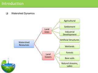
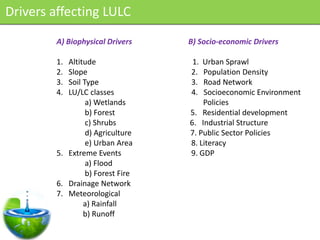
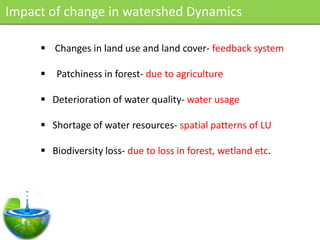
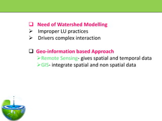
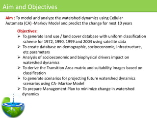
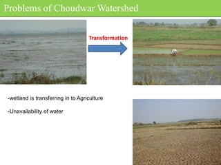
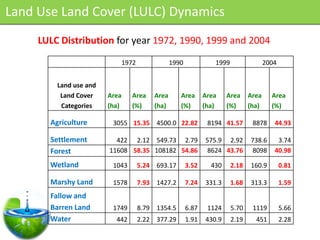
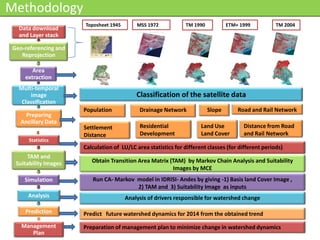
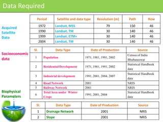
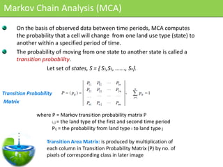
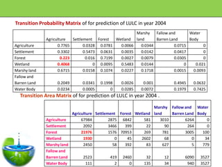
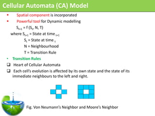
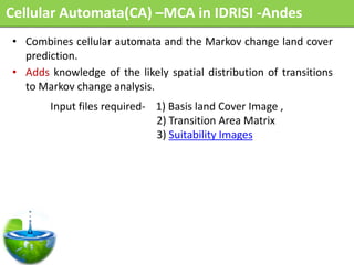
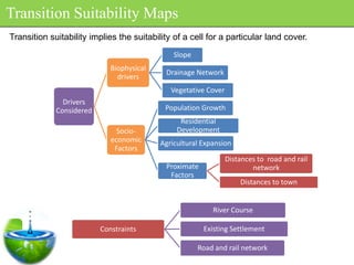
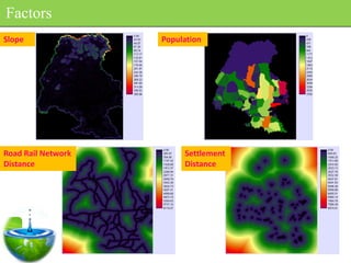
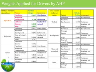
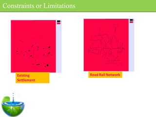
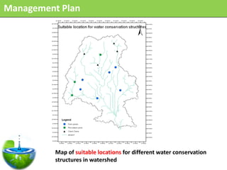
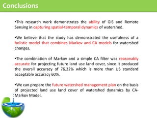
Modelled and Analysed the watershed Dynamics in Mahanadi River Basin. Finally came up with watershed Management Plan to minimise the future LUCC in Mahanadi River Basin
Smart Materials ppt, Smart or intelligent materials are materials that have to respond to stimuli and environmental changes, Detailed Engineering Project Research on Smart Materials, smart and composite materials, smart materials in construction, smart materials in engineering, its about smart or say intelligent materials
This presentation gives a brief introduction on FRC's history, definition and why is it used. Types of FRC's and it's applications is explained in detail in later stages.Also, it covers various properties that affects FRC and a Case study in end.
Structural health monitoring refers to the process of implementing a damage detection and characterization strategy for engineering structures such as bridges and buildings.
This presentation includes in how many ways plastic can be used in soil stabilization. It covers how a waste material can be used without any additional increase in cost.
Final Year Project Report Sample for Engineers - IIT and State UniversityHitesh Sharma
A sample report for all final year college students, for Engineering and Management Branch.
Best for Mechanical and Core branch students.
Includes - First Page, Index Style, Abstract, Body, COnsclusion and Designing Methods.
Share and Support this file, thanks and also fo for my other uploads.
Following are some suggestions for future research. As GFRSCC technology is now being adopted in many ountries throughout the world, in the absence of suitable standardized test methods it is necessary to examine the existing test methods and identify or, when necessary, develop test methods suitable for acceptance as international Standards. Such test methods have to be capable of a rapid and reliable assessment of key
properties of fresh SCC on a construction site. At the same time, the testing equipment should be reliable, easily portable and inexpensive. The test procedure should be carried
out by a single operator and the test results have to be interpreted with a minimum of
training. Also, the results have to define and specify different GFRSCC mixes. One
primary application of these test methods would be in verification of compliance on sites
and in concrete production plants, if self- compacting concrete could be manufactured in
large quantities..
General steps of the finite element methodmahesh gaikwad
General Steps used to solve FEA/ FEM Problems. Steps Involves involves dividing the body into a finite elements with associated nodes and choosing the most appropriate element type for the model.
Applications of Artificial Neural Networks in Civil EngineeringPramey Zode
An artificial brain-like network based on certain mathematical algorithms developed using a numerical computing environment is called as an ‘Artificial Neural Network (ANN)’. Many civil engineering problems which need understanding of physical processes are found to be time consuming and inaccurate to evaluate using conventional approaches. In this regard, many ANNs have been seen as a reliable and practical alternative to solve such problems. Literature review reveals that ANNs have already being used in solving numerous civil engineering problems. This study explains some cases where ANNs have been used and its future scope is also discussed.
Seminar presentation made by me for the topic of 'Resources for Sentiment Analysis' at IIT Bombay. Includes a set of bonus slides for additional information which was not actually presented.
Following are some suggestions for future research. As GFRSCC technology is now being adopted in many countries throughout the world, in the absence of suitable
standardized test methods it is necessary to examine the existing test methods and identify or, when necessary, develop test methods suitable for acceptance as International Standards. Such test methods have to be capable of a rapid and reliable assessment of key
properties of fresh SCC on a construction site. At the same time, the testing equipment should be reliable, easily portable and inexpensive. The test procedure should be carried out by a single operator and the test results have to be interpreted with a minimum of training. Also, the results have to define and specify different GFRSCC mixes. One primary application of these test methods would be in verification of compliance on sites and in concrete production plants, if self- compacting concrete could be manufactured in large quantities..
Dr. Shamasundar spoke about the thermal management in transformers, different cooling methods and how simulation through JMAG can help you design an Efficient Transformer.
Automatic Train Collision and Accidence Avoidance systemPradeepRaj
This is an idea presentation, which can be implemented in near future to drastically reduce the rate of train accidents.
It is based on the concept of Piezoelectric sensor, Ultrasonic sensor and Pattern recognition.
this presentation is about the reuse of treated wastewater.Different application and technologies involved. I have also put four case studies taken from some journals mentioned.
Modelling and Analyzing the Watershed Dynamics using Cellular Automata (CA) -...John Kingsley
SCHOOL OF WATER RESOURCES INDIAN INSTITUTE OF TECHNOLOGY KHARAGPUR
M.Tech Thesis Presentation
Need of Watershed Modelling
Impact of change in watershed Dynamics
Problems of Choudwar Watershed Transformatio
Land Use Land Cover
Change detection analysis in land use / land cover of Pune city using remotel...Nitin Mundhe
Lecture delivered in the National Conference entitled “Monitoring Degraded Lands” jointly organized by Agasti Arts, Commerce and Dadasaheb Rupwate Science
College, Akole and Maharashtra Bhugolshastra Parishad Pune to be held on 4 to 6 February 2014.
Presented by Salman Asif Siddiqui (ICIMOD) at the CGIAR-CSI Annual Meeting 2009: Mapping Our Future. March 31 - April 4, 2009, ILRI Campus, Nairobi, Kenya
Application of Remote Sensing Techniques for Change Detection in Land Use/ La...iosrjce
IOSR Journal of Applied Geology and Geophysics (IOSR-JAGG) is a double blind peer reviewed International Journal that provides rapid publication (within a month) of articles in all areas of Applied Geology and Geophysics. The journal welcomes publications of high quality papers on theoretical developments and practical applications in Applied Geology and Geophysics. Original research papers, state-of-the-art reviews, and high quality technical notes are invited for publications.
Watershed management: Role of Geospatial Technologyamritpaldigra30
Watershed management is the study of the relevant characteristics of a watershed which is done to enhance watershed functions that affect the plant, animal and human or other living communities within the watershed boundary.
This PPT dscribes the Role of Geospatial Technology in Watershed Management
identification of ground water potential zones using gis and remote sensingtp jayamohan
the identification of ground water potential zones using gis and remote sensing.The study is conducted in the Muvattupuzha block.The various parameters used are geology,geomorphology,rainfall,soil type,etc.
Assessment of Land Use Land Cover Classification through Geospatial Approach:...Premier Publishers
Earth's land use/land cover (LC/LU) classification provides valuable information particularly on natural resources, mapping and its monitoring. There is a significant change on LC/LU across the globe due to the climatic changes, rapid increase in population and over demand of economic natural resources. Remote Sensing (RS) satellite data with its synoptic view and multispectral data provides essential information in proper planning of LU/LC conditions of larger areas. The study aims to map and monitor the existing LU/LC classification scientifically using geospatial tools in database generation, analyses and information extraction. Thematic maps of the study area are prepared using satellite images in conjunction with collateral data Survey of India (SoI) toposheets, forest and wasteland maps. An attempt have been made to delineate the Level-I, Level-II and Level-III LU/LC classification system through NRSC guidelines (2011) using both Digital Image Processing (DIP) and Visual Image Interpretation Techniques (VIIT) by GIS software’s with limited Ground Truth Check (GTC). More accurate classification is observed in case of digital technique as compared to that of visual technique in terms of area statistics. The final results highlight the potentiality of geospatial technique in optimal and sustainable land use planning of natural resource and its management.
Search and Society: Reimagining Information Access for Radical FuturesBhaskar Mitra
The field of Information retrieval (IR) is currently undergoing a transformative shift, at least partly due to the emerging applications of generative AI to information access. In this talk, we will deliberate on the sociotechnical implications of generative AI for information access. We will argue that there is both a critical necessity and an exciting opportunity for the IR community to re-center our research agendas on societal needs while dismantling the artificial separation between the work on fairness, accountability, transparency, and ethics in IR and the rest of IR research. Instead of adopting a reactionary strategy of trying to mitigate potential social harms from emerging technologies, the community should aim to proactively set the research agenda for the kinds of systems we should build inspired by diverse explicitly stated sociotechnical imaginaries. The sociotechnical imaginaries that underpin the design and development of information access technologies needs to be explicitly articulated, and we need to develop theories of change in context of these diverse perspectives. Our guiding future imaginaries must be informed by other academic fields, such as democratic theory and critical theory, and should be co-developed with social science scholars, legal scholars, civil rights and social justice activists, and artists, among others.
Dev Dives: Train smarter, not harder – active learning and UiPath LLMs for do...UiPathCommunity
💥 Speed, accuracy, and scaling – discover the superpowers of GenAI in action with UiPath Document Understanding and Communications Mining™:
See how to accelerate model training and optimize model performance with active learning
Learn about the latest enhancements to out-of-the-box document processing – with little to no training required
Get an exclusive demo of the new family of UiPath LLMs – GenAI models specialized for processing different types of documents and messages
This is a hands-on session specifically designed for automation developers and AI enthusiasts seeking to enhance their knowledge in leveraging the latest intelligent document processing capabilities offered by UiPath.
Speakers:
👨🏫 Andras Palfi, Senior Product Manager, UiPath
👩🏫 Lenka Dulovicova, Product Program Manager, UiPath
The Art of the Pitch: WordPress Relationships and SalesLaura Byrne
Clients don’t know what they don’t know. What web solutions are right for them? How does WordPress come into the picture? How do you make sure you understand scope and timeline? What do you do if sometime changes?
All these questions and more will be explored as we talk about matching clients’ needs with what your agency offers without pulling teeth or pulling your hair out. Practical tips, and strategies for successful relationship building that leads to closing the deal.
Epistemic Interaction - tuning interfaces to provide information for AI supportAlan Dix
Paper presented at SYNERGY workshop at AVI 2024, Genoa, Italy. 3rd June 2024
https://alandix.com/academic/papers/synergy2024-epistemic/
As machine learning integrates deeper into human-computer interactions, the concept of epistemic interaction emerges, aiming to refine these interactions to enhance system adaptability. This approach encourages minor, intentional adjustments in user behaviour to enrich the data available for system learning. This paper introduces epistemic interaction within the context of human-system communication, illustrating how deliberate interaction design can improve system understanding and adaptation. Through concrete examples, we demonstrate the potential of epistemic interaction to significantly advance human-computer interaction by leveraging intuitive human communication strategies to inform system design and functionality, offering a novel pathway for enriching user-system engagements.
State of ICS and IoT Cyber Threat Landscape Report 2024 previewPrayukth K V
The IoT and OT threat landscape report has been prepared by the Threat Research Team at Sectrio using data from Sectrio, cyber threat intelligence farming facilities spread across over 85 cities around the world. In addition, Sectrio also runs AI-based advanced threat and payload engagement facilities that serve as sinks to attract and engage sophisticated threat actors, and newer malware including new variants and latent threats that are at an earlier stage of development.
The latest edition of the OT/ICS and IoT security Threat Landscape Report 2024 also covers:
State of global ICS asset and network exposure
Sectoral targets and attacks as well as the cost of ransom
Global APT activity, AI usage, actor and tactic profiles, and implications
Rise in volumes of AI-powered cyberattacks
Major cyber events in 2024
Malware and malicious payload trends
Cyberattack types and targets
Vulnerability exploit attempts on CVEs
Attacks on counties – USA
Expansion of bot farms – how, where, and why
In-depth analysis of the cyber threat landscape across North America, South America, Europe, APAC, and the Middle East
Why are attacks on smart factories rising?
Cyber risk predictions
Axis of attacks – Europe
Systemic attacks in the Middle East
Download the full report from here:
https://sectrio.com/resources/ot-threat-landscape-reports/sectrio-releases-ot-ics-and-iot-security-threat-landscape-report-2024/
Essentials of Automations: Optimizing FME Workflows with ParametersSafe Software
Are you looking to streamline your workflows and boost your projects’ efficiency? Do you find yourself searching for ways to add flexibility and control over your FME workflows? If so, you’re in the right place.
Join us for an insightful dive into the world of FME parameters, a critical element in optimizing workflow efficiency. This webinar marks the beginning of our three-part “Essentials of Automation” series. This first webinar is designed to equip you with the knowledge and skills to utilize parameters effectively: enhancing the flexibility, maintainability, and user control of your FME projects.
Here’s what you’ll gain:
- Essentials of FME Parameters: Understand the pivotal role of parameters, including Reader/Writer, Transformer, User, and FME Flow categories. Discover how they are the key to unlocking automation and optimization within your workflows.
- Practical Applications in FME Form: Delve into key user parameter types including choice, connections, and file URLs. Allow users to control how a workflow runs, making your workflows more reusable. Learn to import values and deliver the best user experience for your workflows while enhancing accuracy.
- Optimization Strategies in FME Flow: Explore the creation and strategic deployment of parameters in FME Flow, including the use of deployment and geometry parameters, to maximize workflow efficiency.
- Pro Tips for Success: Gain insights on parameterizing connections and leveraging new features like Conditional Visibility for clarity and simplicity.
We’ll wrap up with a glimpse into future webinars, followed by a Q&A session to address your specific questions surrounding this topic.
Don’t miss this opportunity to elevate your FME expertise and drive your projects to new heights of efficiency.
Smart TV Buyer Insights Survey 2024 by 91mobiles.pdf91mobiles
91mobiles recently conducted a Smart TV Buyer Insights Survey in which we asked over 3,000 respondents about the TV they own, aspects they look at on a new TV, and their TV buying preferences.
UiPath Test Automation using UiPath Test Suite series, part 4DianaGray10
Welcome to UiPath Test Automation using UiPath Test Suite series part 4. In this session, we will cover Test Manager overview along with SAP heatmap.
The UiPath Test Manager overview with SAP heatmap webinar offers a concise yet comprehensive exploration of the role of a Test Manager within SAP environments, coupled with the utilization of heatmaps for effective testing strategies.
Participants will gain insights into the responsibilities, challenges, and best practices associated with test management in SAP projects. Additionally, the webinar delves into the significance of heatmaps as a visual aid for identifying testing priorities, areas of risk, and resource allocation within SAP landscapes. Through this session, attendees can expect to enhance their understanding of test management principles while learning practical approaches to optimize testing processes in SAP environments using heatmap visualization techniques
What will you get from this session?
1. Insights into SAP testing best practices
2. Heatmap utilization for testing
3. Optimization of testing processes
4. Demo
Topics covered:
Execution from the test manager
Orchestrator execution result
Defect reporting
SAP heatmap example with demo
Speaker:
Deepak Rai, Automation Practice Lead, Boundaryless Group and UiPath MVP
PHP Frameworks: I want to break free (IPC Berlin 2024)Ralf Eggert
In this presentation, we examine the challenges and limitations of relying too heavily on PHP frameworks in web development. We discuss the history of PHP and its frameworks to understand how this dependence has evolved. The focus will be on providing concrete tips and strategies to reduce reliance on these frameworks, based on real-world examples and practical considerations. The goal is to equip developers with the skills and knowledge to create more flexible and future-proof web applications. We'll explore the importance of maintaining autonomy in a rapidly changing tech landscape and how to make informed decisions in PHP development.
This talk is aimed at encouraging a more independent approach to using PHP frameworks, moving towards a more flexible and future-proof approach to PHP development.
Key Trends Shaping the Future of Infrastructure.pdfCheryl Hung
Keynote at DIGIT West Expo, Glasgow on 29 May 2024.
Cheryl Hung, ochery.com
Sr Director, Infrastructure Ecosystem, Arm.
The key trends across hardware, cloud and open-source; exploring how these areas are likely to mature and develop over the short and long-term, and then considering how organisations can position themselves to adapt and thrive.
Neuro-symbolic is not enough, we need neuro-*semantic*Frank van Harmelen
Neuro-symbolic (NeSy) AI is on the rise. However, simply machine learning on just any symbolic structure is not sufficient to really harvest the gains of NeSy. These will only be gained when the symbolic structures have an actual semantics. I give an operational definition of semantics as “predictable inference”.
All of this illustrated with link prediction over knowledge graphs, but the argument is general.
FIDO Alliance Osaka Seminar: Passkeys at Amazon.pdf
M.Tech Final Seminar
1. SCHOOL OF WATER RESOURCES
INDIAN INSTITUTE OF TECHNOLOGY KHARAGPUR
Modelling and Analyzing the Watershed Dynamics using
Cellular Automata (CA) -Markov Model –A Geo-information
Based Approach
M.Tech Thesis Presentation
Supervisor
DR. M. D. BEHERA
Presented By
Mr. SANTOSH NAVNATH BORATE
Date: 04-05-2010 08WM6002
2. Outline of Presentation
• Introduction
• Aim and Objectives
• Study Area
• Methodology
• Model Description
• Results and Discussions
• Watershed Management Plan
• Conclusions
3. Introduction
Watershed Dynamics
Agricultural
Settlement
Land
Uses Industrial
Development
Artificial Structures
Watershed
Resources
Wetlands
Forests
Land
Covers
Bare soils
Natural streams,
Lakes
4. Drivers affecting LULC
A) Biophysical Drivers B) Socio-economic Drivers
1. Altitude 1. Urban Sprawl
2. Slope 2. Population Density
3. Soil Type 3. Road Network
4. LU/LC classes 4. Socioeconomic Environment
a) Wetlands Policies
b) Forest 5. Residential development
c) Shrubs 6. Industrial Structure
d) Agriculture 7. Public Sector Policies
e) Urban Area 8. Literacy
5. Extreme Events 9. GDP
a) Flood
b) Forest Fire
6. Drainage Network
7. Meteorological
a) Rainfall
b) Runoff
5. Impact of change in watershed Dynamics
Changes in land use and land cover- feedback system
Patchiness in forest- due to agriculture
Deterioration of water quality- water usage
Shortage of water resources- spatial patterns of LU
Biodiversity loss- due to loss in forest, wetland etc.
6. Need of Watershed Modelling
Improper LU practices
Drivers complex interaction
Geo-information based Approach
Remote Sensing- gives spatial and temporal data
GIS- integrate spatial and non spatial data
7. Aim and Objectives
Aim : To model and analyze the watershed dynamics using Cellular
Automata (CA) -Markov Model and predict the change for next 10 years
Objectives:
To generate land use / land cover database with uniform classification
scheme for 1972, 1990, 1999 and 2004 using satellite data
To create database on demographic, socioeconomic, Infrastructure,
etc parameters
Analysis of socioeconomic and biophysical drivers impact on
watershed dynamics
To derive the Transition Area matrix and suitability images based on
classification
To generate scenarios for projecting future watershed dynamics
scenarios using CA- Markov Model
To prepare Management Plan to minimize change in watershed
dynamics
8. Study Area- Choudwar Watershed
River basin
map of India
• Drainage Area = 195 sq.km
• Latitude- 20 29’33 to 20 40’21 N
•Longitude- 85 44’59.33 to 85 54’16.62 E
•Growing Industrial Area
Mahanadi
River Basin
9. Problems of Choudwar Watershed
Transformation
-wetland is transferring in to Agriculture
-Unavailability of water
10. Land Use Land Cover (LULC) Dynamics
LULC Distribution for year 1972, 1990, 1999 and 2004
1972 1990 1999 2004
Land use and
Land Cover Area Area Area Area Area Area Area Area
Categories (ha) (%) (ha) (%) (ha) (%) (ha) (%)
Agriculture 3055 15.35 4500.0 22.82 8194 41.57 8878 44.93
Settlement 422 2.12 549.73 2.79 575.9 2.92 738.6 3.74
Forest 11608 58.35 108182 54.86 8624 43.76 8098 40.98
Wetland 1043 5.24 693.17 3.52 430 2.18 160.9 0.81
Marshy Land 1578 7.93 1427.2 7.24 331.3 1.68 313.3 1.59
Fallow and
Barren Land 1749 8.79 1354.5 6.87 1124 5.70 1119 5.66
Water 442 2.22 377.29 1.91 430.9 2.19 451 2.28
11. Methodology
Toposheet 1945 MSS 1972 TM 1990 ETM+ 1999 TM 2004
Data download
and Layer stack
Geo-referencing and
Reprojection
Area
extraction
Multi-temporal
image Classification of the satellite data
Classification
Population Drainage Network Slope Road and Rail Network
Preparing
Ancillary Data
Settlement Residential Land Use Distance from Road
Distance Development Land Cover and Rail Network
Statistics
Calculation of LU/LC area statistics for different classes (for different periods)
TAM and
Suitability Images Obtain Transition Area Matrix (TAM) by Markov Chain Analysis and Suitability
Images by MCE
Simulation Run CA- Markov model in IDRISI- Andes by giving -1) Basis land Cover Image ,
2) TAM and 3) Suitability Image as inputs
Analysis Analysis of drivers responsible for watershed change
Prediction Predict future watershed dynamics for 2014 from the obtained trend
Management Preparation of management plan to minimize change in watershed dynamics
Plan
12. Data Required
Period Satellite and data type Resolution (m) Path Row
1972 Landsat, MSS 79 150 46
Acquired
Satellite 1990 Landsat, TM 30 140 46
Data 1999 Landsat, ETM+ 30 140 46
2004 Landsat, TM 30 140 46
Sl. Data Type Date of Production Source
Socioeconomic Census of India
1 Population 1971, 1981, 1991, 2002
data Bhubaneswar
Statistical Handbook
2 Residential Development 1971, 1981, 1991, 2002
data
Statistical Handbook
3 Industrial development 1991, 2001, 2004, 2007
data
4 Road Network 2001 NRIS
5 Railway Network 2001 NRIS
Biophysical Total Area under Winter Statistical Handbook
6 1991, 2001, 2004
Parameters Crops data
Sl. Data Type Date of Production Source
1 Drainage Network 2001 NRIS
2 Slope 2001 NRIS
13. 1990
1972 1990
Legend
road rail network
Agriculture
Land use Land Cover Settlement
2004
Classification Forest
wetland
Marshyland
Fallow and Barren Land
Water Body
16. Correlation between different factors
No of Total Area Number of
Population Settlement Agriculture House under Winter Industries and Forest
hold Crops Mining’s
1 0.89 0.91 - - - -0.99
Population
Settlement 0.89 1 0.89 0.94
Agriculture 0.91 0.87 1 - 0.95 0.97 -
No of House - 0.94 - 1
hold
Total Area
- - 0.95 - 1 - -
under winter
crops
Number of
0.97
Industries - - - - 1 -
and Mining’s
Forest - - -0.99 - - - 1
17. Markov Chain Analysis (MCA)
On the basis of observed data between time periods, MCA computes
the probability that a cell will change from one land use type (state) to
another within a specified period of time.
The probability of moving from one state to another state is called a
transition probability.
Let set of states, S = { S1,S2, ……., Sn}.
Transition Probability
Matrix
where P = Markov transition probability matrix P
i, j = the land type of the first and second time period
Pij = the probability from land type i to land type j
Transition Area Matrix: is produced by multiplication of
each column in Transition Probability Matrix (P) by no. of
pixels of corresponding class in later image
18. Transition Probability Matrix of for prediction of LULC in year 2004
Marshy Fallow and Water
Agriculture Settlement Forest Wetland land Barren Land Body
Agriculture 0.7765 0.0328 0.0781 0.0066 0.0344 0.0715 0
Settlement 0.3302 0.5473 0.0631 0.0035 0.0142 0.0417 0
Forest 0.223 0.016 0.7199 0.0027 0.0079 0.0305 0
Wetland 0.4068 0 0.0095 0.5483 0.0144 0 0.021
Marshy land 0.6715 0.0158 0.1074 0.0227 0.1718 0.0015 0.0093
Fallow and
Barren Land 0.2049 0.0341 0.1998 0.0026 0.001 0.4945 0.0632
Water Body 0.0234 0.0005 0 0.0285 0.0072 0.1979 0.7425
Transition Area Matrix of for prediction of LULC in year 2004 .
Marshy Fallow and Water
Agriculture Settlement Forest Wetland land Barren Land Body
Agriculture 67984 2875 6842 581 3010 6264 0
Settlement 2092 3466 399 22 90 264 0
Forest 21976 1576 70953 269 781 3005 100
Wetland 1930 0 45 2602 68 0 34
Marshy land 2450 58 392 83 627 5 779
Fallow and
Barren Land 2523 419 2460 32 12 6090 3527
Water Body 111 2 0 135 34 940 3527
19. Cellular Automata (CA) Model
Spatial component is incorporated
Powerful tool for Dynamic modelling
St+1 = f (St, N, T)
where St+1 = State at time t+1
St = State at time t
N = Neighbourhood
T = Transition Rule
• Transition Rules
Heart of Cellular Automata
Each cell’s evolution is affected by its own state and the state of its
immediate neighbours to the left and right.
Fig. Von Neumann’s Neighbor and Moore’s Neighbor
20. Cellular Automata(CA) –MCA in IDRISI -Andes
• Combines cellular automata and the Markov change land cover
prediction.
• Adds knowledge of the likely spatial distribution of transitions
to Markov change analysis.
Input files required- 1) Basis land Cover Image ,
2) Transition Area Matrix
3) Suitability Images
21. Transition Suitability Maps
Transition suitability implies the suitability of a cell for a particular land cover.
Slope
Biophysical
Drainage Network
drivers
Vegetative Cover
Drivers
Considered Population Growth
Residential
Socio- Development
economic Agricultural Expansion
Factors
Distances to road and rail
Proximate network
Factors
Distances to town
River Course
Constraints Existing Settlement
Road and rail network
22. Factors
Slope Population
Road Rail Network Settlement
Distance Distance
23. Weights Applied for Drivers by AHP
Land use and land Relative Land use and
cover classes Factors Weight Constraints land cover Relative
Population 0.1837 River Course classes Factors Weight Constraints
Residential Population 0.1031 River Course
Development 0.206 Settlement Residential
Agriculture
settlement Road and rail Wetland Development 0.1078 Settlement
Distance 0.5668 network Road and rail
slope 0.0435 Slope 0.7891 network
Population 0.1617 River Course Population 0.0744 River Course
Residential Drainage
Development 0.1703 Settlement distance 0.6042 Settlement
Road rail network Road and rail Marshy Land Road and rail
Settlement
distance 0.0908 network Slope 0.2007 network
Slope 0.057 Road rail
Settlement network distance 0.1207
Distance 0.5202 Population 0.2202 River Course
Population 0.1188 River Course Residential
Residential Fallow and Development 0.2169 Settlement
Development 0.1188 Settlement barren land Settlement Road and rail
Forest Road rail network Road and rail Distance 0.494 network
distance 0.0678 network
Slope 0.0689
Slope 0.3897 Agriculture
Population 0.0953 Settlement
Settlement
Road and rail
Distance 0.3049
Water Slope 0.6548 network
Drainage
distance 0.2499
26. CA-Markov Output
Predicted Land Use Land cover Actual Land Use Land cover
map for year 2004 map for year 2004
27. CA-Markov Output
Predicted Land Use Land cover
map for year 2014
28. Management Plan
Objectives considered
• To construct the small water and soil conservation structures at gullies.
• To participate rural peoples and stakeholder for prevent land degradation and
watershed management activities.
• Improvement of agriculture production.
• Use of Remote Sensing and GIS
Decision Rules decision rules are formulized for selection of sites for various soil and
water conservation structures as per the guidelines given by Integrated Mission for
Sustainable Development (IMSD, 1995), Indian National Committee on Hydrology
(INCOH)
Structures Area Slope Permeability Run-off Land Use
Potential
Check dam - Gentle to steep Low to Medium Hilly area
slope Medium
Percolation >40 ha Nearly Level to Medium to Low/Medium Near stream
Pond Gentle slope high
Irrigation 2 ha Nearly level to Very Low Low/Medium Agriculture
Tank Gentle slope
29. Management Plan
Map of suitable locations for different water conservation
structures in watershed
30. Conclusions
•This research work demonstrates the ability of GIS and Remote
Sensing in capturing spatial-temporal dynamics of watershed.
•We believe that the study has demonstrated the usefulness of a
holistic model that combines Markov and CA models for watershed
changes.
•The combination of Markov and a simple CA filter was reasonably
accurate for projecting future land use land cover, since it produced
the overall accuracy of 76.22% which is more than US standard
acceptable accuracy 60%.
•We can prepare the future watershed management plan on the basis
of projected land use land cover of watershed dynamics by CA-
Markov Model.