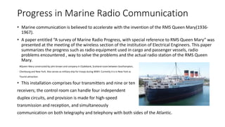
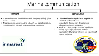
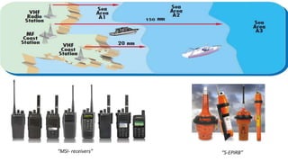
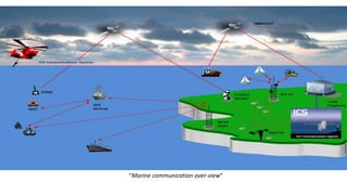
Marine communication refers to the exchange of information between vessels at sea or between vessels and shore stations. It has evolved from early flag signaling to modern radio technologies. Key developments include the early use of radio telegraphy using Morse code, integration of VHF radio with digital selective calling for ship-to-ship and ship-to-shore communication, establishment of satellite systems like INMARSAT for global coverage, and adoption of the Global Maritime Distress Safety System (GMDSS) to standardize radio equipment required on ships based on their area of operation. Modern marine communication systems aim to ensure vessels can reliably exchange information to aid navigation and quickly transmit distress signals.
Marine radars are usually short range radars that are used by ships to pinpoint locations about other ships and land in the area.The frequencies with which these radars are operated are known as x-band or s-band frequencies.
ECDIS: New standards & old underwater rocksLearnmarine
Webinar on: IHO S-52 Presentation Library 4.0, ECDIS as an anti-grounding device, Safety Contour and Safety Depth setup, information layers, utilities.
A presentation on 'The International Convention for Preventing Collisions at Sea 1972' (COLREG 72) to the LLM Maritime Law students at University of Southampton.
Presentation on maneuvering and collision avoidance with special focus on large tonnage vessels.
Maneuverability limits and last moment maneuver are thoroughly shown in this material.
Decoding SOLAS (Safety of Life at Sea) by SHM ShipcareSHM Shipcare
105 years ago, on the same day - April 15th, the World witnessed the most disastrous shipping accident of all times - The Titanic. Legendary in every sense, RMS Titanic was designed by the Irish shipbuilder William Pirrie and built in Belfast, and was thought to be the world’s fastest ship. It spanned 883 feet from stern to bow, and its hull was divided into 16 compartments that were presumed to be watertight. Titanic was presumed to be unsinkable. But, no one had thought about the damage, an iceberg could cause. Only 10% of an iceberg is seen above the water while the rest lies below it. While in the final leg of it's journey from England to New York, the luxurious cruise liner failed to change its course and damaged its hull, causing water to flood into all the compartments, eventually leading to the ship breaking in half and a human loss of 1522 passengers. This disaster has served as a lesson for the shipping fraternity which gave birth to SOLAS and International Ice Patrol. Read more about SOLAS in our exclusive post here: http://www.shmgroup.com/blog/understanding-shipping-safety-with-solas/
This is an introduction to the marine AIS (Automatic Identification System), its technology and user devices that take advantage of the system. You may find this useful if you are a skipper of an ocean going vessel, are working in highly congested waterways or journalist/researcher needing to understand AIS in more depth.
SOLAS:The International Convention for the Safety of Life at Sea (SOLAS) is an international maritime treaty which sets minimum safety standards in the construction, equipment and operation of merchant ships. The convention requires signatory flag states to ensure that ships flagged by them comply with at least these standards.
We are an independent industry-specific and professional language training agency and consultancy with a specialism in Maritime English.
We offer outstanding Maritime English courses worldwide. Our courses are delivered by in-house trainers, specialist English schools, or online.
You can also prepare to pass the international MarTEL tests.
Ship owners, managers, officers and crew need cost-effective communications that are simple to operate, easy to maintain and operate seamlessly around the world. That’s what Singtel Office At Sea offer. Our services and technology can bridge Inmarsat, Iridium, VSAT, WiFi and mobile access automatically to provide voice, Internet, email and high-value applications from weather data to ship management tools wherever the vessel travels.
Seminario formacion basica packs de bateriasMiki Perez
Seminario destinado a la comprensión del proceso de diseño y creación de packs de baterías.
Conceptos de serie y paralelo. Nomenclatura. Cálculo de parámetros intrínsecos : capacidad global, corrientes de carga y descarga permitidos, células básicas y tecnologías de packs.
Introducción a las bancadas de baterías, construcción de una bancada, elementos constructivos. Seguridad.
The Global Maritime Distress and Safety System (GMDSS) automates and improves emergency communications for the world's shipping industry. The system incorporates satellite communications and traditional radio technologies to provide modernized maritime distress and safety communications for the 21st century.
Stay on Course_ The Importance of Marine Radars for Boaters.pdforbitshub
In recent years, marine radar technology has advanced significantly, with the integration of features such as Automatic Radar Plotting Aid (ARPA) and collision avoidance systems. ARPA utilizes radar data to track the movement of other vessels and predict potential collisions, providing early warnings to navigators. Collision avoidance systems employ algorithms to analyze radar data and suggest evasive maneuvers to prevent accidents.
Characteristics of good seaport and principles of seaport planning, size of seaport, site selection criteria and layout of seaport, Dry ports, Bulk cargo, Transshipment ports, Port of call, Surveys to be carried out for seaport planning, regional and intercontinental transportation development, forecasting cargo & passenger demand, regional connectivity, cargo handling capacity of port.
Architecture of the regional satellite augmentation system for maritime appli...TELKOMNIKA JOURNAL
This paper describes architecture of regional satellite augmentation system (RSAS) in the function of the maritime space communications, navigation and surveillance (CNS) and global navigation satellite systems (GNSS) networks for enhanced safety and surveying of oceangoing ships, management and tracking of cargo, security of Mariners onboard commercial and passenger ships, yachts, sea platforms and other types of craft. The RSAS network are designed to improve vessel management and transport operation because of the enormous expansion of the world's merchant fleet. However, this network with a special ship tracking system can also improve the protection of merchant ships and their crews against piracy, violence, robbery and terrorist attacks. The international maritime organization (IMO) and shipping flag states have project for development of the international ship and port security (ISPS) and design to implement an approaching and port control system (APCS) by special code for all merchant vessels including determination, tracking and positioning of all ships movements in and out of the seaport area. The Maritime RSAS and CNS systems are integration components of the global satellite augmentation systems (GSAS) of two operational GNSS-1 military networks, such as the US global position system (GPS) and Russian global satellite navigation system (GLONASS). In this paper are also introduced the special effects of the ships RSAS networks and coastal movement guidance and control (CMGC) system for maritime application at sea and in seaports areas.
Harbours: History of water transportation, components of harbour, classification of harbours.
Introduction of Transportation Engineering
Harbours Engineering maximum data use for civil engineering students.
Saudi Arabia stands as a titan in the global energy landscape, renowned for its abundant oil and gas resources. It's the largest exporter of petroleum and holds some of the world's most significant reserves. Let's delve into the top 10 oil and gas projects shaping Saudi Arabia's energy future in 2024.
About
Indigenized remote control interface card suitable for MAFI system CCR equipment. Compatible for IDM8000 CCR. Backplane mounted serial and TCP/Ethernet communication module for CCR remote access. IDM 8000 CCR remote control on serial and TCP protocol.
• Remote control: Parallel or serial interface.
• Compatible with MAFI CCR system.
• Compatible with IDM8000 CCR.
• Compatible with Backplane mount serial communication.
• Compatible with commercial and Defence aviation CCR system.
• Remote control system for accessing CCR and allied system over serial or TCP.
• Indigenized local Support/presence in India.
• Easy in configuration using DIP switches.
Technical Specifications
Indigenized remote control interface card suitable for MAFI system CCR equipment. Compatible for IDM8000 CCR. Backplane mounted serial and TCP/Ethernet communication module for CCR remote access. IDM 8000 CCR remote control on serial and TCP protocol.
Key Features
Indigenized remote control interface card suitable for MAFI system CCR equipment. Compatible for IDM8000 CCR. Backplane mounted serial and TCP/Ethernet communication module for CCR remote access. IDM 8000 CCR remote control on serial and TCP protocol.
• Remote control: Parallel or serial interface
• Compatible with MAFI CCR system
• Copatiable with IDM8000 CCR
• Compatible with Backplane mount serial communication.
• Compatible with commercial and Defence aviation CCR system.
• Remote control system for accessing CCR and allied system over serial or TCP.
• Indigenized local Support/presence in India.
Application
• Remote control: Parallel or serial interface.
• Compatible with MAFI CCR system.
• Compatible with IDM8000 CCR.
• Compatible with Backplane mount serial communication.
• Compatible with commercial and Defence aviation CCR system.
• Remote control system for accessing CCR and allied system over serial or TCP.
• Indigenized local Support/presence in India.
• Easy in configuration using DIP switches.
HEAP SORT ILLUSTRATED WITH HEAPIFY, BUILD HEAP FOR DYNAMIC ARRAYS.
Heap sort is a comparison-based sorting technique based on Binary Heap data structure. It is similar to the selection sort where we first find the minimum element and place the minimum element at the beginning. Repeat the same process for the remaining elements.
We have compiled the most important slides from each speaker's presentation. This year’s compilation, available for free, captures the key insights and contributions shared during the DfMAy 2024 conference.
Overview of the fundamental roles in Hydropower generation and the components involved in wider Electrical Engineering.
This paper presents the design and construction of hydroelectric dams from the hydrologist’s survey of the valley before construction, all aspects and involved disciplines, fluid dynamics, structural engineering, generation and mains frequency regulation to the very transmission of power through the network in the United Kingdom.
Author: Robbie Edward Sayers
Collaborators and co editors: Charlie Sims and Connor Healey.
(C) 2024 Robbie E. Sayers
Hierarchical Digital Twin of a Naval Power SystemKerry Sado
A hierarchical digital twin of a Naval DC power system has been developed and experimentally verified. Similar to other state-of-the-art digital twins, this technology creates a digital replica of the physical system executed in real-time or faster, which can modify hardware controls. However, its advantage stems from distributing computational efforts by utilizing a hierarchical structure composed of lower-level digital twin blocks and a higher-level system digital twin. Each digital twin block is associated with a physical subsystem of the hardware and communicates with a singular system digital twin, which creates a system-level response. By extracting information from each level of the hierarchy, power system controls of the hardware were reconfigured autonomously. This hierarchical digital twin development offers several advantages over other digital twins, particularly in the field of naval power systems. The hierarchical structure allows for greater computational efficiency and scalability while the ability to autonomously reconfigure hardware controls offers increased flexibility and responsiveness. The hierarchical decomposition and models utilized were well aligned with the physical twin, as indicated by the maximum deviations between the developed digital twin hierarchy and the hardware.
block diagram and signal flow graph representation
Marine communication
1. MARINE COMMUNICATION
“Short history”
• The correct use of marine radios
communication is paramount to safe
boating and in the right hands, a
marine radios can save life and
property.
Presenter: Sagun Subedi
MOKPO NATIONAL UNIVERSITY
2. It is necessary to understand difference the between the term marine and maritime communication.
There is very little difference. Both come from the Latin word for 'sea' which is mare, Maris. Thus,
'marine' directly relates to the sea, while 'maritime' relates to things associated with the sea.
Marine
• Marine is an adjective meaning
of or pertaining to the sea, as in
'marine biology,' the study of life
in the sea.
• He was a marine in World War II.
Maritime
• Maritime is an adjective meaning
pertaining to objects or actions
related to or conducted on the sea,
as in 'maritime history,' which is
the study of events that have
occurred on the high seas,
shipping, commerce, discovery.
• We enjoyed maritime activities
such as kayaking and deep sea
diving.
3. Marine communication
• As it is known that earth consists of 70% water and it can be predicted
that marine communication is vast than terrestrial communication.
• Marine communication refers to the Information exchange between sea
things as ships or other equipment floating or under seaocean.
• Initially for this communication flag semaphore were used.
Flag semaphore is the telegraphy system conveying information at a distance by means of visual signals with hand-held flags,
rods, disks, paddles, or occasionally bare or gloved hands. Information is encoded by the position of the flags; it is read when the
flag is in a fixed position.
4. • Earlier in the 17th century ship to ship or ship to shore communication was
watched by the skilled radio officers which latter was replaced by radio
telegraphy using Morse code.
• Marine communication between ship to shore and ship to ship is carried out
by very high frequency (VHF) radio. Digital selective calling (DSC) is now being
integrated with VHF as per SOLAS (safety of life at sea) convection.
• DSC come with digital remote commands to transmit or receive distress
alert, urgent or safety and routine priority message.
5. Progress in Marine Radio Communication
• Marine communication is believed to accelerate with the invention of the RMS Queen Mary(1936-
1967).
• A paper entitled “A survey of Marine Radio Progress, with special reference to RMS Queen Mary” was
presented at the meeting of the wireless section of the institution of Electrical Engineers. This paper
summarizes the progress such as radio equipment used in cargo and passenger vessels, radio
problems encountered , way to solve the problems and the actual radio station of the RMS Queen
Mary.
#Queen Mary constructed by john brown and company in Clydebank, Scotland route between Southampton,
Cherbourg and New York. Also serves as military ship for troops during WWII. Currently it is in New York as
Tourist attraction.
• This installation comprises four transmitters and nine or ten
receivers; the control room can handle four independent
duplex circuits, and provision is made for high-speed
transmission and reception, and simultaneously
communication on both telegraphy and telephony with both sides of the Atlantic.
6. Marine communication
INMARSAT
It is British satellite telecommunication company, offering global
mobile services.
The organization was created to establish and operate a satellite
communications network for the maritime community.
COSPAS-SARSAT
The International Cospas-Sarsat Program is a
satellite-based search and
rescue (SAR) distress alert detection and
information distribution system.
As of 2011, 26 country ( including republic of
Korea), regional governments and one
organization (Chunghwa Telecom) are providers of
ground segments.
7. Cell phones age:
• In early 70s, cell phones were developed, though they provide the
convenience of simple, easy-to-use, inexpensive, private and generally
reliable telephone service to home, office, automobile or other locations
yet they weren’t and still aren’t used as the mean of communication in
marine system. Here are some reasons behind them.
• Most cell phones are designed for a land-based service. Their coverage offshore is limited, and
may change without notice .
• If distress call is made on the cell phones only one party you call will be able to hear you.
• Locating a cell caller is hard to do. If you don’t know your location, the coast guard will have
difficulty finding your location on the water.
8. VHF radios
• VHF marine radios were designed with safety in mind, i.e. if you are in distress, calls can be received
not only by the coast guard but by ships which may be in position to give immediate assistance.
• A VHF marine radio also helps ensure that storm warnings and other urgent marine information
broadcasts are received.
• VHF radios can be used anywhere around the world.
“VHF radios”
10. For international operational requirements, the global
maritime distress safety system (GMDSS) has divided world
into four sub areas.
• Area A1: lies within range of shore-based VHF coast stations (up to about 20 NM);
• VHF equipment, S-EPIRB or VHF EPIRB, MSI receiver.
• Area A2: lies within range of shore based MF coast stations (excluding A1 areas) (up to about 150
NM) ;
• VHF and MF equipment, S-EPIRB, MSI receiver.
• Area A3: lies within the coverage area of INMARSAT communications satellites (excluding A1 and
A2 areas- approximately between latitude 70 degrees north to latitude 70 degrees south);
• VHF, MF and HF or satellite equipment, S-EPIRB, MSI receiver.
• Area A4: comprises the remaining sea areas outside A1, A2, A3 (the polar regions);
• VHF, MF and HF equipment, 406 MHZ S-EPIRB, MSI receiver.
# NM/M/nmi is unit of distance that is approximately one minute of arc measured along any meridian i.e. 1,852 meter or 6,076 feet.