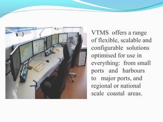
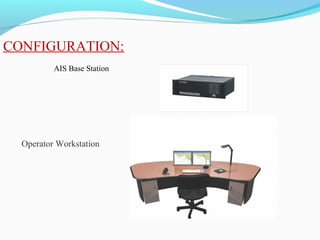
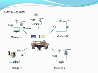
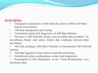
The document describes a Vessel Traffic Management System (VTMS) that offers solutions for managing vessel traffic in ports, harbors, and coastal areas. The main objectives of a VTMS are to provide enhanced situational awareness, exchange information with AIS-equipped vessels, and ensure safety, security, and environmental protection. A typical VTMS configuration includes AIS base stations, operator workstations, radar sensors, CCTV, weather systems, and a central server to collect and distribute information.
Rolta Vessel Traffic Management System (VTMS) makes significant contribution to more secure route, efficient traffic flow, and insurance of the environment in confined and busy waterways by active monitoring, provision of information services, traffic management and navigational help to vessels. To achieve above goals Rolta offers accurate components like radar, day/night vision tracking system, AIS, DF, ENC, hydrological and meteorological sensors and many more. Because of these components, VTMS encourages fast and efficient handling of Incidents and crisis circumstances.
Presentation on maneuvering and collision avoidance with special focus on large tonnage vessels.
Maneuverability limits and last moment maneuver are thoroughly shown in this material.
This document provides an overview of differential GPS (DGPS) and its history. It explains that DGPS uses fixed, ground-based reference stations to broadcast corrections to improve GPS accuracy from 15 meters to about 10 cm. Selective availability was introduced by the US military to degrade civilian GPS but was turned off in 2000. DGPS was developed as a solution, broadcasting corrections to offset errors and allow 5 meter accuracy, meeting most civilian needs. It has expanded to cover many waterways through systems like the US Coast Guard's National DGPS.
This is an introduction to the marine AIS (Automatic Identification System), its technology and user devices that take advantage of the system. You may find this useful if you are a skipper of an ocean going vessel, are working in highly congested waterways or journalist/researcher needing to understand AIS in more depth.
The Global Maritime Distress and Safety System (GMDSS) automates distress alerting and provides for improved safety communications at sea. Under GMDSS, search and rescue authorities and nearby ships will be rapidly alerted to a ship in distress through shore-based coordination. GMDSS also transmits maritime safety information. Ships are equipped according to the communication capabilities required for the area in which they operate, divided into Sea Areas 1 through 4 with varying coverage ranges. GMDSS aims to speed rescue responses and improve safety of ships and their crews over previous manual systems.
The document describes various navigational instruments and systems used on ships. It provides brief descriptions of instruments such as the gyrocompass, magnetic compass, radar, sonar, fish finder, Automatic Radar Plotting Aid (ARPA), Electronic Chart Display and Information System (ECDIS), Automatic Identification System (AIS), marine autopilots, rudder angle indicator, voyage data recorder, Global Positioning System (GPS), chart plotter, marine VHF radio, public address system, rate of turn indicator, close-quarters monitor, log, echosounder, radio altimeter, Long Range Tracking and Identification (LRIT) system, Global Maritime Distress and Safety System (GMDSS), anemometer
What will the ship of the future look like? According to proponents of the vision behind autonomous shipping, It will be unmanned, run by artificial intelligence. Learn more about this exciting topic in this video.
For the video please visit https://www.youtube.com/watch?v=L3HQC9B2OO8&list=PLVce3C5Hi9BBfabvhEzYQTQDYEg2vtuxH&index=20
This slideshare has been produced by the Tesseract Academy (http://tesseract.academy), a company that educates decision makers in deep technical topics such as data science, analytics, machine learning and blockchain.
If you are interested in data science and related topics, make sure to also visit The Data Scientist: http://thedatascientist.com.
1. The document discusses the operational use of radar and ARPA, including fundamental radar principles, safe distances, radiation hazards, radar components, factors affecting performance, and interpretation of radar pictures.
2. It describes how radar works by transmitting electromagnetic pulses that bounce off objects and return, allowing the distance to be calculated. On ships, radar is used for collision avoidance and navigation assistance.
3. Key factors that influence radar detection range and resolution are discussed, such as wavelength, antenna height, target size, weather conditions, and more. Interpreting radar images requires experience due to effects like radar shadows and multiple echoes.
The document discusses factors affecting ship handling both internally and externally. Internal factors include engine power, propeller, rudder, anchors, and thrusters. External factors include tide, wind, current, proximity of other vessels, and harbor depth. It then discusses principles of ship handling and how ships move longitudinally, laterally, and rotationally. Finally, it discusses the effects of wind and current on ship handling in detail covering topics like windage area, trim, headway, and sternway.
This document provides an overview of shiphandling theory and practices. It covers key topics such as laws of motion, controllable and uncontrollable forces acting on a ship, terminology, ground tackle, mooring, getting underway, single and twin screw characteristics, standard commands between the conning officer and helm, and maneuvering considerations. The document is intended to teach the essential information needed for shiphandling watches and operations.
ARPA, or Automatic Radar Plotting Aid, is sophisticated navigation equipment found on most ocean-going vessels that combines radar display with computer tracking. It tracks radar contacts, calculating their course, speed, closest point of approach, and time to collision to assess collision risk. ARPA computes this information and displays it along with the radar to aid navigators, especially in busy or low-visibility areas. It allows for automatic and manual target acquisition and tracking, and prediction of target motion through vectors or graphical displays.
The document describes various types of cargo handling equipment used in ports and terminals. It discusses bulk cargo, liquid cargo, and general cargo handling equipment, which can be divided into four main categories: conveyors, cranes, industrial cranes, and manual shifting. Specific conveyor types are then outlined, along with their main uses and characteristics. Common crane types like jib cranes, bridge cranes, gantry cranes, and stacker cranes are also summarized.
The document discusses the development of autonomous ships. It describes several autonomous shipping projects including the world's first autonomous shipping company established by Wilhelmsen and KONGSBERG, and Rolls-Royce's partnership with Google to create smarter autonomous ships using machine learning. It also discusses Yara Birkeland, the world's first fully electric and autonomous container ship, and a demonstration of the world's first fully autonomous ferry in Finland. The document outlines some of the key technologies needed for autonomous ships including advanced sensor modules, deep sea navigation systems, remote maneuvering support systems, and engine monitoring and control systems. It describes the role of shore control centers in monitoring and assisting autonomous ships.
The document discusses the International Convention on Load Lines of 1966 which establishes uniform principles and rules regarding load lines on ships involved in international voyages. It outlines the requirements for assigning freeboards based on zones and seasons, surveying and certifying ships, marking load lines on ships, and other provisions to ensure ships are properly loaded for safety and stability in various weather conditions around the world. The convention aims to determine safe limits of load lines for ships to maintain adequate freeboard and prevent overloading.
VDR is a marine recording device that functions like an aircraft's black box, recording critical ship data and communications to help investigators determine the cause of accidents. A VDR continuously records data from navigational equipment, alarms, and communications for at least 12 hours. This data is stored in a protective capsule that can withstand fire and deep water immersion. Accessing and analyzing VDR data after an incident allows for faster, more accurate investigations that help improve safety. VDR recordings have also assisted ship owners in assessing bridge team performance and identifying areas for improvement.
The document provides an overview of key rules and definitions from the Navigation Rules for Marine Law Enforcement Officers. It defines terms like vessel, underway, power-driven and sailing vessels. It outlines lighting requirements and sound signals. It discusses rules for determining risk of collision, taking action to avoid collision, operating in narrow channels, overtaking situations, head-on encounters, and crossing situations.
Robert Watson-Watt invented radar in the 1930s while working for the British government. He developed devices for detecting atmospheric discharges and locating approaching aircraft. This led to the development of radar which played a key role in Britain's defense during World War 2.
Radar systems use radio waves that are transmitted and reflected to detect objects. The components of a radar system include a transmitter, antenna, receiver, and indicator. The transmitter creates pulses that are emitted by the antenna. The receiver detects reflections and the indicator, usually a cathode ray tube, displays the results.
Air traffic control radars include Precision Approach Radar for precision landing, Airport Surveillance Radar for short range surveillance, Air Route Surveillance Radar for long
This document summarizes different types of ships that have developed since 1800 to transport various cargoes. It describes how after World War 2, ships became more specialized to carry only one type of cargo, such as oil tankers, chemical tankers, container ships, and reefers. The document then provides examples and images of these specialized ship types that developed to transport liquids, bulk goods, containers, vehicles, passengers, and for recreation.
This document discusses communication and information technology used in maritime transportation. It begins by explaining how computerization has become standard in the maritime industry. It then describes Inmarsat, the international maritime satellite organization, including the different types of satellite services it provides for ship communications. Finally, it discusses how electronic data interchange and internet EDI are used to facilitate paperless documentation and information sharing between maritime stakeholders.
The document provides guidance on passage planning for ships. It discusses key terms, guidelines and components to consider when creating a passage plan. The main components are appraisal, planning, execution and monitoring. Appraisal involves considering relevant information about the ship, cargo, crew, and voyage. Planning includes plotting the intended route on charts and noting safety elements. Execution is conducting the passage according to the plan, adjusting as needed. Monitoring involves checking progress and equipment performance against the plan. The overall purpose is to ensure safe and efficient navigation while protecting the environment.
Digital Selective Calling (DSC) is used to transmit distress alerts from ships and acknowledgements from coast stations, as well as for other safety calls. DSC uses error detection coding and transmits information such as the vessel's identity and type of call. DSC calls can be distress, safety, or commercial. Receiving stations display the call details and provide alarms for distress or safety calls. DSC operates at different speeds and frequencies depending on the band, and repeats distress calls to increase the chances of detection.
Recent technology developments in the information technology space have opened new horizons for the maritime industry. "Digital ports" refers to application of digital technologies of digital technologies such as machine learning, data analytics, visualization, cloud and advanced wireless communications technology to the Port Ecosystem that are driving innovations and enabling business efficiency.
This document discusses various aspects of seamanship and marine navigation. It begins by defining seamanship as the art possessed by seafarers to safely operate ships at sea. Seamanship is evolutionary as skills are acquired over time through experience, and dynamic as the skills needed vary between roles and adapt with new technology. The document then discusses four main types of navigation: piloting, dead reckoning, celestial navigation, and radio navigation. It also defines key terms used in marine navigation like the prime meridian, nautical mile, magnetic north versus true north. The document provides diagrams and descriptions of the key parts of a research vessel and typical ship. It concludes by classifying ships according to their purposes and support types.
A ship's crew is divided into three main departments: the deck department oversees navigation and cargo operations; the engineering department maintains machinery and systems; and the steward's department is responsible for catering. Each department has a well-defined hierarchy and roles, from the captain and chief engineer down to more junior crew members, with areas of responsibility that are integral to the safe and efficient operation of the vessel.
This document discusses the key features and importance of sea ports. It outlines that ports are historic commercial hubs that require large investments and provide infrastructure to support national economies. The document describes the evolution of ports from basic cargo facilities to modern integrated hubs. It also outlines different types of ports and approaches to port management, noting the goal of efficiently supporting trade and generating economic benefits.
An autopilot is a navigational device that automatically steers a ship or aircraft along a steady course. It works by receiving input on the desired course from devices like a GPS and then using actuators to control the rudder to maintain that heading. The main modes of an autopilot are manual, where the user controls steering, auto where the autopilot maintains the current course, and GPS mode where it follows a route from a GPS unit. Understanding how an autopilot works helps ensure safe navigation at sea.
The document summarizes a study on port cargo handling technologies. It identifies 10 groups of cargo and 8 areas of cargo handling to focus the study. The groups include cereals, containers, dangerous goods, etc. The areas include ERP systems, gate systems, handling equipment, infrastructures, and more. It outlines the study approach, which will describe technologies, assess market status and trends, and interview ports. The study found that automation and advanced technologies can improve efficiency by increasing throughput and optimizing operations to address land constraints. Technologies like mega-cranes, automated guided vehicles, asset tracking systems, and automated storage and retrieval may significantly boost performance once fully implemented.
Este documento describe cómo calcular rutas de navegación utilizando líneas loxodrómicas y círculos máximos en una aplicación de navegación. Explica que las líneas loxodrómicas se usan para distancias cortas y los círculos máximos para distancias más largas. Detalla los pasos para introducir las coordenadas de origen y destino y calcular la ruta, el rumbo y la distancia para ambos tipos de rutas.
1. Indonesia has over 150,000 small fishing boats and 5,457 larger boats that require licenses and monitoring to prevent overfishing and illegal fishing.
2. Indonesia implemented a Vessel Monitoring System (VMS) using satellites and GPS to track registered fishing vessels and improve fisheries management.
3. The VMS allows Indonesia to monitor fishing vessel positions and activity, ensure compliance with regulations, and optimize sustainable use of fisheries resources.
Real time ship tracking system using ais dataChathura
This document outlines the development of a real-time ship tracking system using AIS data that will allow users to view ships broadcasting their identity, position, course, speed and destination on an interactive map. The system will display individual vessel information with a single click and allow filtering ships by type, course, speed and other selection criteria. It will also show additional port details as the user zooms in. The goal is for users to be able to monitor ship movements in Sri Lankan waters from a desktop application in real-time.
South africa’s ports system & position, enables it to access to south south t...Transnet Port Terminals
South Africa's port system enables access to various trade routes due to its strategic geographic position. Transnet operates South Africa's ports and rail infrastructure. It has several business units, including Transnet National Ports Authority which manages ports, Transnet Port Terminals which operates cargo terminals, and Transnet Freight Rail which operates rail freight transportation. The port of Durban is the busiest in Africa in terms of vessel calls and ranks second in container throughput on the continent.
90% of Everything. WebGL in the Shipping IndustryJosh Staples
Want to ship a cold beverage from Germany? It'll cost you a penny per beverage.
Have some fresh fish to fillet? Shipping it to Asia and back is cheaper than filleting it locally.
Shipping is a huge industry involving giant robots, gargantuan container ships, pirates, unions, a bandwidth of 17 million containers and trillions upon trillions of dollars. Its an industry where any port downtime can ruin an entire country's economy and oddly enough an industry where only 36% of goods are delivered on time.
Given the latter, when implementing a Terminal Operating Systems it is in everybody's interest to minimize downtime. Learn how Navis is leveraging WebGL and JavaScript to extend the UI and UX functionality of their flagship product while keeping ports up and running.
Joshua Staples is a Senior Software Engineer at Navis, a company which provides software solutions for shipping terminals around the world. He has a background in both Fine Arts and Computer Engineering with 3D experience ranging from Autodesk to NOAA. Currently he finds himself creating next-gen WebGL applications for use with Navis’ flag-ship product, the N4 Terminal Operating System.
This presentation is unique. I can not find any assignment about Port Management in Site. So I have uploaded this presentation as a result students understand about Port Management System's E-R Diagram, Flowchart, and DFD.
Thank You
The document discusses supervisory control and data acquisition (SCADA) systems. It defines SCADA and provides a brief history. It describes common SCADA components like remote terminal units (RTU), programmable logic controllers (PLC), human-machine interfaces, and data acquisition servers. It discusses the system components, future trends moving to networked systems, and applications in power system automation including intelligent electronic devices and automation processes. It concludes that India is moving towards greater power grid automation for increased efficiency and standardization.
The Impact on the Information Technology, Automation Technology and Equipment...Siddharth Chandrasekar
This document discusses the impact of information technology, automation technology, and equipment on port supply chains. It notes that integration of the supply chain and use of technologies like EDI and a terminal operating system have increased efficiency at ports like Singapore. Automation technologies like a terminal logistics control system, equipment monitoring systems, remote-controlled cranes, and RFID have increased speed, safety, and flexibility while reducing congestion. The document concludes that ports integrated with value-added services through efficient information sharing and technology innovation can better connect to the global supply chain.
The document provides an overview of terminal operations at Kuala Lumpur International Airport. It discusses the objectives, roles, and responsibilities of the Terminal Services Division, which manages terminal operations and coordinates with airport partners to ensure efficient and customer-focused services. Standard operating procedures and people practices are outlined covering inspections, handling VIPs, incidents, maintenance, and more. The overall goal is to provide a hassle-free environment for passengers.
This document provides an introduction and overview of an Automated Traffic Management System (ATMS). The key points are:
- ATMS aims to ensure smooth traffic flow, increase transportation efficiency, and enhance road safety through real-time traffic monitoring, emergency response coordination, and dynamic message displays.
- The main components of ATMS include emergency call boxes, variable message signs, automatic traffic counters, meteorological data stations, video incident detection systems, radio communication systems, CCTV cameras, and a control room.
- The control room integrates data from all components, monitors traffic and road conditions, controls variable signs, manages incidents and emergencies, and generates reports. It allows operators to oversee the entire
The Republic of Panama has implemented an LRIT system to track over 8,000 SOLAS class ships on its registry. Panama purchased the LRIT system in 2008 through an international tender. The system is operated by Absolute Maritime Tracking Services and includes ASP, conformance testing, and data center services. The Panama National Data Center is located in Panama City and has achieved over 99.7% operational availability since 2009. It processes LRIT position reports and shares them with other countries via the International Data Exchange.
INNAV - VTMIS
Information Navigation System e Vessel Traffic Management Information System (System Management and Vessel Traffic Information). This is a significant technological advance for our ports, for the VTMIS team the main and busiest terminals in the world.
The VTMIS is an electronic aid to navigation system, able to provide active monitoring of maritime traffic.
The Victoria Harbour was the first in Brazil to hire the system. The Dock Company of the Holy Spirit (Codesa).
The document describes an Insight Management System that provides asset management capabilities including:
- Remote monitoring and control of offshore assets from shoreside control centers for maintenance, safety, and performance.
- Real-time fleet visibility across mobile and portable devices through a common operating picture with alarm notifications and drill-down diagnostics.
- Improved productivity through remote support, automated record keeping and supply chain management, reducing time spent on paperwork and dockside resupply.
The document discusses the Shipborne Automatic Identification System (AIS), which is used on ships and vessels to identify and locate nearby ships and exchange information with shore stations. AIS transmits dynamic information like position, speed, and heading, as well as static vessel details. It consists of VHF transmitters and receivers, with timing from GNSS. There are Class A and B systems, with Class A mandated for large commercial vessels. AIS has benefits like enhanced situational awareness but also errors if data is incorrect. It contributes to safety and traffic management.
YARIS (Yaounde Architecture Regional Information System) is a web-based platform to share and analyse information within the 27 maritime centres of the Gulf of Guinea
The document discusses securing data centers from cyber threats. It describes how attacks have evolved from manual to mechanized to sophisticated human-led attacks. It advocates employing segmentation, threat defense and visibility measures like firewalls, IDS/IPS, and NetFlow. The Cisco Cyber Threat Defense solution places these tools at the access, aggregation and core layers, including the ASA firewall, Nexus switches, and StealthWatch for network monitoring and analytics. This provides visibility into network traffic across physical and virtual infrastructure to detect threats and policy violations.
Accessing new tech. trends for the rapid tactical command rtc.ZikweMsimang
The persistent onslaught waged on the rural populations and wildlife resources within sub-Sahara Africa's Central, East & Southern Regions, effecting its flora, fauna & human spectrum has tripled with no sign of stopping the rapid extermination of our Donkeys, Elephants, Rhinos & Pangolin species within the projected x(5) year timeline. These {1-of 3-part} poster series are aimed at qualified consorts that have expressed interest into engaging the initial "Critical Disaster Logistics Call-out" of {02/04/18} and still want to register their names must do so forth-worth with actual occupation-held presently, to enable consideration for opportunities that offer their "expertise" in the {Rapid Tactical Command.} a regional Ranger Para.Military {C4.ISR.} Division. For those cognisant in [3GPP/Ind 4.0/5G} technological orientation, with emphasis on [IIoT-IoRT/5G] for the "Inter-Community Rural Development Campus" to be held at circa: [03/22] aimed at enhancing our sub-regional security units capability and readiness at deployment of advanced tactical response levels, required to protect our regional and rural-based critical infrastructure and resources that are under "dire" threat and need our utmost engagement urgently!...this call-out is not aimed at "non-Vertical" entities, and requisites a detailed (CV) to place you appropriately on this essential mission orientation with field experienced "Game Rangers" primarily focused to engage. NB: [This notification is NOT a rehearsal] - ZMB.
Our Marine Software called TrackPro is a unique solution for performance management in marine operations. It reduces fuel consumption and emissions, and increases availability and safety on a single vessel, or on a whole fleet of vessels.
The document discusses the implementation and benefits of a GPS-based Truck Dispatch System (TDS) at an opencast coal mine in India. Key points:
- The TDS uses GPS to track equipment location in real-time, optimizing shovel-dumper allocation and routes to increase utilization and productivity.
- Benefits included reduced attendance and allocation time, dynamic reallocation of dumpers during breakdowns, improved monitoring and route optimization, and early detection of equipment issues through online vital sign monitoring.
- Productivity increased through more efficient shovel-dumper coordination, less idle time, and preventative maintenance enabled by real-time health monitoring of dumpers.
Stephan Gerling in Bucharest, Romania on November 8-9th 2018 at DefCamp #9.
The videos and other presentations can be found on https://def.camp/archive
The document provides information about the Global System for Mobile Communications (GSM) cellular standard. It describes GSM as a digital cellular system using TDMA and FDMA. Key aspects of GSM discussed include its architecture, protocols, interfaces, services, and operation. The architecture includes the network switching subsystem (NSS) and base station subsystem (BSS). The NSS contains elements like the mobile switching center (MSC) and home location register (HLR). The BSS contains the base transceiver station (BTS) and base station controller (BSC). Interfaces like A, Abis, and GSM signaling are also covered.
This document provides an overview of intelligent transportation systems (ITS). It discusses ITS technologies like wireless communications, sensors for vehicle detection, and video detection. It also outlines ITS applications such as electronic toll collection using FASTags, variable message signs, automatic road enforcement with cameras, and collision avoidance systems. The benefits of ITS are described as time savings, improved safety, reduced crashes and costs. Potential challenges are also noted around integration and high equipment/maintenance expenses.
Sperry's Surface Data Logging services provide real-time acquisition and monitoring of drilling data to improve decision making. Experts monitor over 600 parameters from rig sensors and third parties to identify conditions like fluid influxes or mud losses. Data is integrated through Halliburton's InSite system and accessible anywhere through remote operating centers. This allows clients to reduce drilling risks and costs through timely intervention based on accurate formation evaluation and pore pressure analysis provided by Surface Data Logging.
Reconstruction of Highway 90 in Mississippi due to Hurricane Katrina, describes the traffic system and ITS devices installed to provide a better and safer traffic route. Presented to the National Rural ITS conference in Anchorage Alaska in 2008 by Acey Roberts.
The document discusses intelligent transportation systems (ITS), which use advanced technologies like electronics, computers, communications, and sensors to provide travelers with important information and improve transportation safety and efficiency. It outlines several ITS technologies including wireless communications, vehicle detection methods, and applications such as electronic toll collection, variable message signs, automatic enforcement, collision avoidance systems, traveler information services, and emergency management. The benefits of ITS include time savings, improved safety, reduced costs and crashes, while the challenges include costs, mixed traffic difficulties, and maintenance expenses. Projected ITS infrastructure benefits from 2000-2020 include substantial savings in accidents, time, fuel, and operating costs.
The document summarizes the functions and responsibilities of the Airports Authority of India (AAI). It discusses how AAI manages airports and airspace in India. It describes the key roles of AAI in air traffic control, installing and maintaining navigation equipment, developing airport infrastructure, and providing emergency services. The document also provides details about specific navigation aids, radar systems, and communication networks that AAI utilizes to manage air traffic safety.
The document describes Visual Network Monitor (VNM), a software system for visually monitoring mobile networks in real-time. VNM allows network operators to see performance metrics and alarms for all network components on interactive maps. It helps operators detect and resolve issues more quickly to improve service quality. VNM supports various mobile network standards and has been successfully implemented by major operators in Ukraine.
DLW is an integrated plant and its manufacturing facilities are flexible in nature. These can be utilized for manufacture of different design of locomotives of various gauges suiting customer requirements and other products.
This document discusses cathodic protection, which uses electric current to control corrosion of buried or submerged metal structures. It specifically focuses on impressed current cathodic protection. Impressed current systems use anodes connected to a DC power source to apply an external current and move the metal surface to a negative potential where it is protected from corrosion. Some key applications discussed include pipelines, ships, offshore platforms, and galvanized steel. The document provides a brief history of cathodic protection and describes the basic corrosion reactions and how impressed current systems work to prevent corrosion.
Cruise missile technology By shailesh shukla pptSHAILESH SHUKLA
Cruise missiles are small, pilotless airplanes powered by turbofan engines that can precisely deliver bombs up to 1,000 miles away. They use various guidance systems like inertial navigation, terrain contour matching, and digital scene mapping to navigate to their targets. Inertial navigation uses accelerometers and gyroscopes to measure movement, while terrain contour matching compares onboard radar measurements to pre-recorded terrain maps to determine location. Cruise missiles offer advantages like low cost and small size, but also have disadvantages like lack of reusability and vulnerability to defenses. Their guidance systems require careful design for accurate target interception.
“STUDY AND FABRICATION OF OUTDOOR MIST/FOG COOLING SYSTEM THROUGH HIGH PRESSU...SHAILESH SHUKLA
This document presents a project on misting technology. It discusses how misting systems work using evaporative cooling to lower air temperatures by up to 15°C. Misting nozzles atomize water into micron-sized droplets to maximize evaporative cooling effect. The project describes system components like high pressure pumps, mist lines, and nozzles. It provides various misting application areas and benefits. Performance parameters, equations, and sample data from a test installation are also included to evaluate system efficiency.
DLW is an integrated plant and its manufacturing facilities are flexible in nature. These can be utilized for manufacture of different design of locomotives of various gauges suiting customer requirements and other products.
A review of the growth of the Israel Genealogy Research Association Database Collection for the last 12 months. Our collection is now passed the 3 million mark and still growing. See which archives have contributed the most. See the different types of records we have, and which years have had records added. You can also see what we have for the future.
A workshop hosted by the South African Journal of Science aimed at postgraduate students and early career researchers with little or no experience in writing and publishing journal articles.
Strategies for Effective Upskilling is a presentation by Chinwendu Peace in a Your Skill Boost Masterclass organisation by the Excellence Foundation for South Sudan on 08th and 09th June 2024 from 1 PM to 3 PM on each day.
The simplified electron and muon model, Oscillating Spacetime: The Foundation...RitikBhardwaj56
Discover the Simplified Electron and Muon Model: A New Wave-Based Approach to Understanding Particles delves into a groundbreaking theory that presents electrons and muons as rotating soliton waves within oscillating spacetime. Geared towards students, researchers, and science buffs, this book breaks down complex ideas into simple explanations. It covers topics such as electron waves, temporal dynamics, and the implications of this model on particle physics. With clear illustrations and easy-to-follow explanations, readers will gain a new outlook on the universe's fundamental nature.
How to Manage Your Lost Opportunities in Odoo 17 CRMCeline George
Odoo 17 CRM allows us to track why we lose sales opportunities with "Lost Reasons." This helps analyze our sales process and identify areas for improvement. Here's how to configure lost reasons in Odoo 17 CRM
Physiology and chemistry of skin and pigmentation, hairs, scalp, lips and nail, Cleansing cream, Lotions, Face powders, Face packs, Lipsticks, Bath products, soaps and baby product,
Preparation and standardization of the following : Tonic, Bleaches, Dentifrices and Mouth washes & Tooth Pastes, Cosmetics for Nails.
How to Add Chatter in the odoo 17 ERP ModuleCeline George
In Odoo, the chatter is like a chat tool that helps you work together on records. You can leave notes and track things, making it easier to talk with your team and partners. Inside chatter, all communication history, activity, and changes will be displayed.
Assessment and Planning in Educational technology.pptxKavitha Krishnan
In an education system, it is understood that assessment is only for the students, but on the other hand, the Assessment of teachers is also an important aspect of the education system that ensures teachers are providing high-quality instruction to students. The assessment process can be used to provide feedback and support for professional development, to inform decisions about teacher retention or promotion, or to evaluate teacher effectiveness for accountability purposes.
Introduction to AI for Nonprofits with Tapp NetworkTechSoup
Dive into the world of AI! Experts Jon Hill and Tareq Monaur will guide you through AI's role in enhancing nonprofit websites and basic marketing strategies, making it easy to understand and apply.
Macroeconomics- Movie Location
This will be used as part of your Personal Professional Portfolio once graded.
Objective:
Prepare a presentation or a paper using research, basic comparative analysis, data organization and application of economic information. You will make an informed assessment of an economic climate outside of the United States to accomplish an entertainment industry objective.
Thinking of getting a dog? Be aware that breeds like Pit Bulls, Rottweilers, and German Shepherds can be loyal and dangerous. Proper training and socialization are crucial to preventing aggressive behaviors. Ensure safety by understanding their needs and always supervising interactions. Stay safe, and enjoy your furry friends!
2. VESSEL TRAFFIC MANAGEMENT SYSTEM:
The task of managing vessel traffic in ports, harbours
and coastal areas places significant demands on those
responsible for
1.safety,
2.security and
3. protection of the environment.
3. VTMS offers a range
of flexible, scalable and
configurable solutions
optimised for use in
everything: from small
ports and harbours
to major ports, and
regional or national
scale coastal areas.
5. MAIN OBJECTIVES:
• Provides enhanced Situational Awareness
• Information exchange with AIS equipped vessels
• Provision of information about AIS equipped vessels
• Traffic analysis
FUNCTIONALITY:
• Single and Multiple AIS sensor support
• Multi-AIS data filtering and integration
• Automatic AIS targets identification
• AIS dynamic and static data presentation
• Reception and Transmission of AIS text telegrams (Transmiss
requires base station)
• Record and Playback
• Extensive Chart functionality
6. AIS-MONITOR
AIS-Monitor provides a powerful and intuitive AIS capability. AIS-Monitor
has user-friendly interface and sophisticated functionality for AIS traffic control.
AIS-Monitor can display up to 500 real-time target tracks.
MAIN OBJECTIVES:
• Provides enhanced Situational Awareness and assistance in target
tracking
•Provision of information about AIS equipped vessels
•AIS dynamic information exchange on vessel movements to
prevent dangerous situations
•AIS tatic information exchange to assist ship-to-ship communication
•VTS data storage for administrative and incident analysis purposes
•Distribution of AIS-related information to interested parties
7.
8. CONFIGURATION:
CCTV System
AIS Base station
Weather System
Radio Direction finder
Central server
VHF Communication system
Operator Workstaion
9. FUNCTIONALITY:
• AIS, CCTV, RDF, Meteo-Hydro sensors support and control
• Multi-AIS data filtering and integration
• Automatic AIS targets acquisition and target drop
• Automatic AIS targets identification
• AIS dynamic and static data presentation
• Transmission/reception of AIS text telegrams
• Sophisticated zones configuration e.g. traffic, guard, auto-
acquisition, responsibility etc.
• Comprehensive configurable Alarms management including
Navigation and Sensor alarms
• Record and Playback
• Extensive Chart functionality including chart
10. MONITOR
MAIN OBJECTIVES:
•Efficient utilisation of port infrastructure (supports ISPS code
compliance)
Monitoring and identification of vessels and other
navigational objects
•Ensures efficient transit
•etection of illegal activity (terrorism, piracy, illegal
immigration, illegal fishing, smuggling)
•Collision Avoidance Provision
•Assistance in search and rescue and to coastguard activities
•VTS data storage for administrative purposes and incident
analysis
11.
12. MAIN OBJECTIVES:
• Vessel traffic management and safety provision in large-scale high- density
ports
• Efficient utilisation of port infrastructure (supports ISPS code
compliance)
• Improve the quality of port services
• Improve economic performance by operational cost savings and increased
efficiency of port operations
• Large scale planning and traffic coordination in regional or national areas
• Detection of illegal activity
13. •To enhance safety of life and property
• Reduce risk associated with marine operations
• Provide primary support for collision avoidance
• Mitigate consequences of incidents, accidents and disasters
• Environmental protection
• Distribute VTS-related information to interested parties
• Store VTS data for administrative purposes and analysis of incidents
• Provide assistance in search and rescue and to coastguard
15. FUNCTIONALITY:
•Radar, AIS, CCTV, RDF, Metro-Hydro sensors support and control
•Multi-radar tracking integration
•Multi-sensor (Radar and AIS) tracking integration
•Manual or automatic target acquisition and drop
•Manual or automatic target identification
•Radar video presentation
•AIS dynamic and static data presentation
•Transmission and reception of AIS text telegrams
•Target simulation (creation, modification, tracking)
•Route management (creation of route lines, routes, route targets mode –
associated alarms generation, route point ETA calculation, Route Profile tool)
16. Central server
Collection and processing of
information from all system
sensors. Distribution and
display of this information
among various operator
workstations
Operator workstation
Displays situation in the system
operating area, presenting the
sensor data and sensor control,
monitoring operation of
system units, generating alarms
and handling system database
MAIN COMPONENTS
Core components
17. Sensor server
Receipt of data from various system
sensors, processing of data from
various system sensors, data
transmission to central server using
TCP/IP protocol
Audio registration server
Digitising,compressing and
transferring audio
information to the central server for
re-recording and playback
radar processor
Radar signal processing, clutter
suppression, initiative target tracking,
radar remote control, sensor status
monitoring, radar maintenance
functionality
18. Sensors:
radar sensor
Generation and display of the traffic
image in the System observation area,
detection and tracking of the targets
AiS Base station
Automatic identification of ships IMO number, MMSI,
callsign and name, reception of messages on coordinates,
course, speed over the ground, reception of data on the rate of
turn, ship type, port of destination and time of arrival in this
port, route plan, availability of dangerous cargo, reception of
static and dynamic data and binary messages
CCTV, Night vision camera
Manual or automatic focusing on a target or
geographical point in the Chart Window,
automatically following the selected target with the
CCTV
19. VHF Communication System
Provides shore to ship VHF
communications for operators
radio direction finder
Scanning of the marine VHF
channels, presentation of the
bearing lines on the Chart window
Hydro- Meteostation / Buoy
Presentation of the different
weather data (temperature, wind
speed, direction, humidity,
rainfall), presentation of the hydro
data (current speed, direction,
wave height)
20. Port Management information System
The PMIS is an advanced information system
providing extensive functionality for managing and
storing different types of data related to ships, ship
visits and port activities.
21. The PMIS interfaces to VTM software (to receive real-time
information and for data exchange with external agencies
(for example, ship agents) via the Internet.
features:
• Input, storage and editing of data on VTM System
information objects (ships, berths, channels etc.)
• Automatic input of information on AIS equipped vessels
• Automatic recording of ship visit data
• Automatic recording of ship position in the System area
• Search for information by the set criterion
• Provision of information on the ship calls to other services
• Automated electronic Log Book
• Use of database information to identify acquired radar targets
• Generation of Vessel Positioning report for a specific moment in time
22.
23. REMOTE TERMINAL:
Remote Terminal provides real time permanent remote access to information
available in the System.
The System is considered by the Remote Terminal as a sensor from which it
receives radar video, all the ship’s AIS data and identification and motion
parameters.
The operator can simultaneously connect to several systems from one
Remote Terminal and display data received from all the systems.
24. Web Access and web Access Server
Web Access Server provides a web based view of the navigational situation
in the area covered by the existing VTM System.
features:
•Full information provided on the system-tracked targets
•Data updated automatically or at user command
•Control of the display area on the chart
•No dedicated software required, except Microsoft Internet Explorer and
Microsoft Java Virtual Machine
•Password-protected access
25. DATABASE WEB SERVER:
Database Web Server provides remote access to PMIS via a standard Internet
browser.
Web Access to PMIS can be used by the managers, charterers and shipping
company agents for entering data on the planned ship visits, for receiving data
on the stay of ships in ports and on the shipping companies and ships.
FEATURES:
•Read and edit access to the PMIS reference books
•Remote access login to PMIS with various access rights (read only, read
and edit)
•Option to restrict access for particular users and/or database
sections
•Full information provided on targets tracked by the System
•Data updated automatically or at user command
26. CONTROL & MONITORING SYSTEM:
Tasks:
•Continuous monitoring via the SNMP (Simple Network Management
Protocol) of the equipment status and parameters
•Turning on/off the equipment power supply
•Computer status monitoring and remote restart
•Monitoring the state of connection with an arbitrary network device with
the set IP address
•Monitoring the status of system software components
•Graphical presentation of information on the state of monitored equipment in
the program window
27. FUNCTIONS:
• Transparent connection of AIS Network clients to Multi AIS Base
Station environment
• AIS data management and routing
• Centralised control and diagnostics of AIS Base Stations
• Services to AIS Network clients, such as online data reception for
surveillance, binary and safety related data exchange between ships
and clients
• AIS data exchange with other National or International AIS Network
systems
• AIS data logging for later retrieval and data processing
• Centralised system configuration, control and diagnostics
• Presentation of AIS information on the Client Workstations over
electronic charts
28. AIS
Automatic Identification System
The Automatic Identification System (AIS) is an automatic tracking system used on
ships and by Vessel traffic services (VTS) for identifying and locating vessels by
electronically exchanging data with other nearby ships and AIS Base stations.
AIS information supplements marine radar, which continues to be the primary method of
collision avoidance for water transport.
A marine traffic coordinator using AIS and radar to manage vessel traffic.
An AIS-equipped system on board a ship presents the bearing and distance of nearby
vessels in a radar-like display format.
A graphical display of AIS data on board a ship.
Information provided by AIS equipment, such as unique identification, position, course,
and speed, can be displayed on a screen or an ECDIS. AIS integrates a standardized VHF
transceiver with a positioning system like GPS receiver, with other electronic navigation
sensors, such as a gyrocompass or rate of turn indicator.
29. AIS
The International Maritime Organization's (IMO) International Convention for the
Safety of Life at Sea (SOLAS) requires AIS to be fitted aboard international voyaging
ships with gross tonnage (GT) of 300 or more tons, and all passenger ships regardless of
size. It is estimated that more than 40,000 ships currently carry AIS class A equipment.[
Applications and limitations
1.1 Collision avoidance
1.2 Vessel traffic services
1.3 Aids to navigation
1.4 Search and rescue
1.5 Accident investigation
1.6 Binary messages
1.7 Computing and networking
1.8 AIS data on the Internet
1.9 Range limitations and space-based tracking
1.10 Type testing and approval