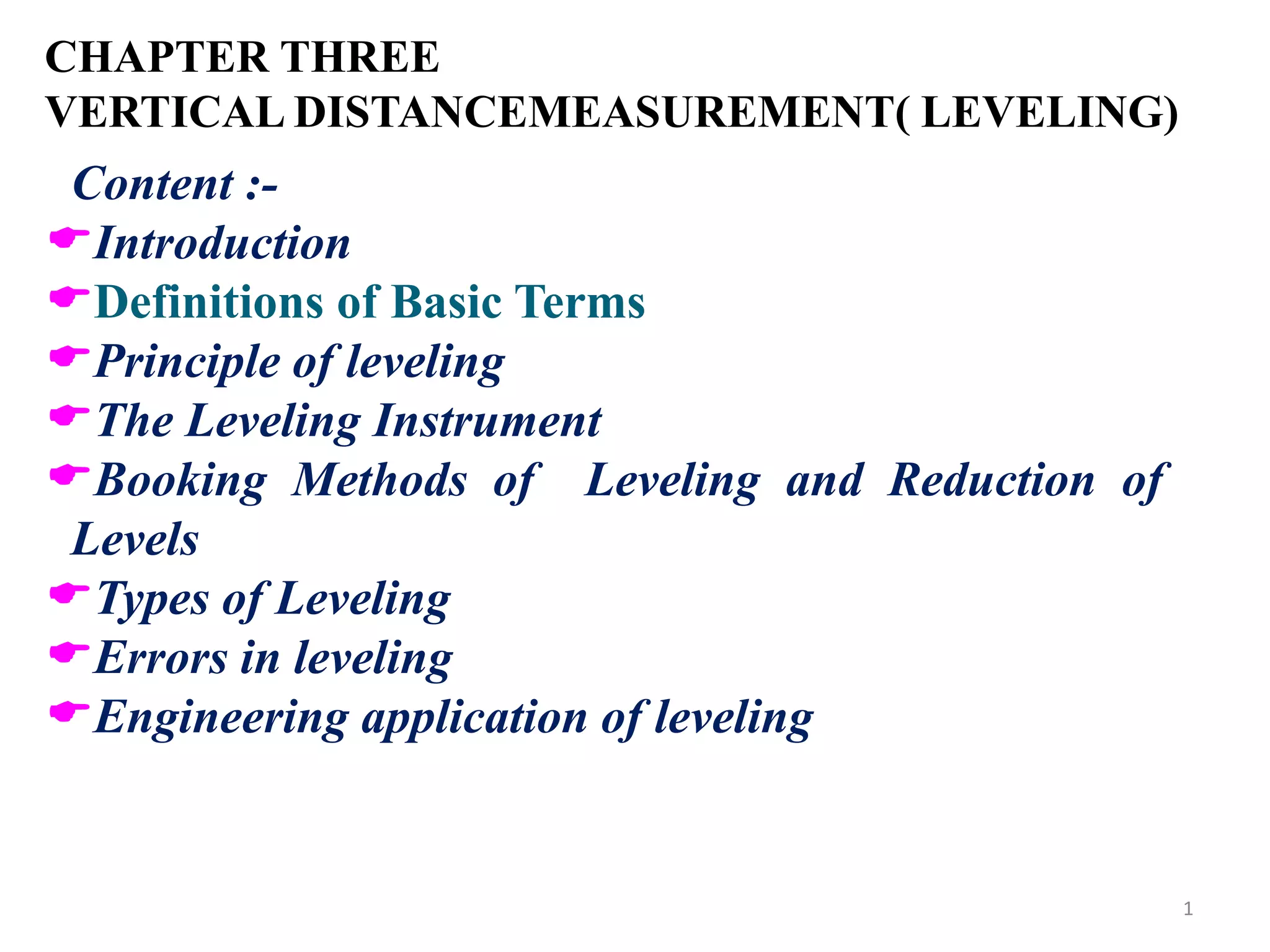
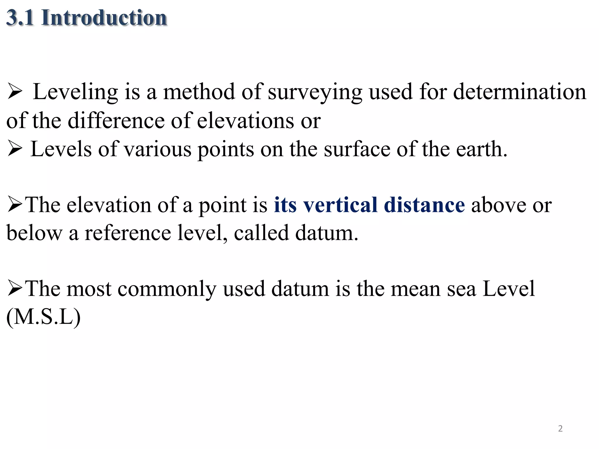
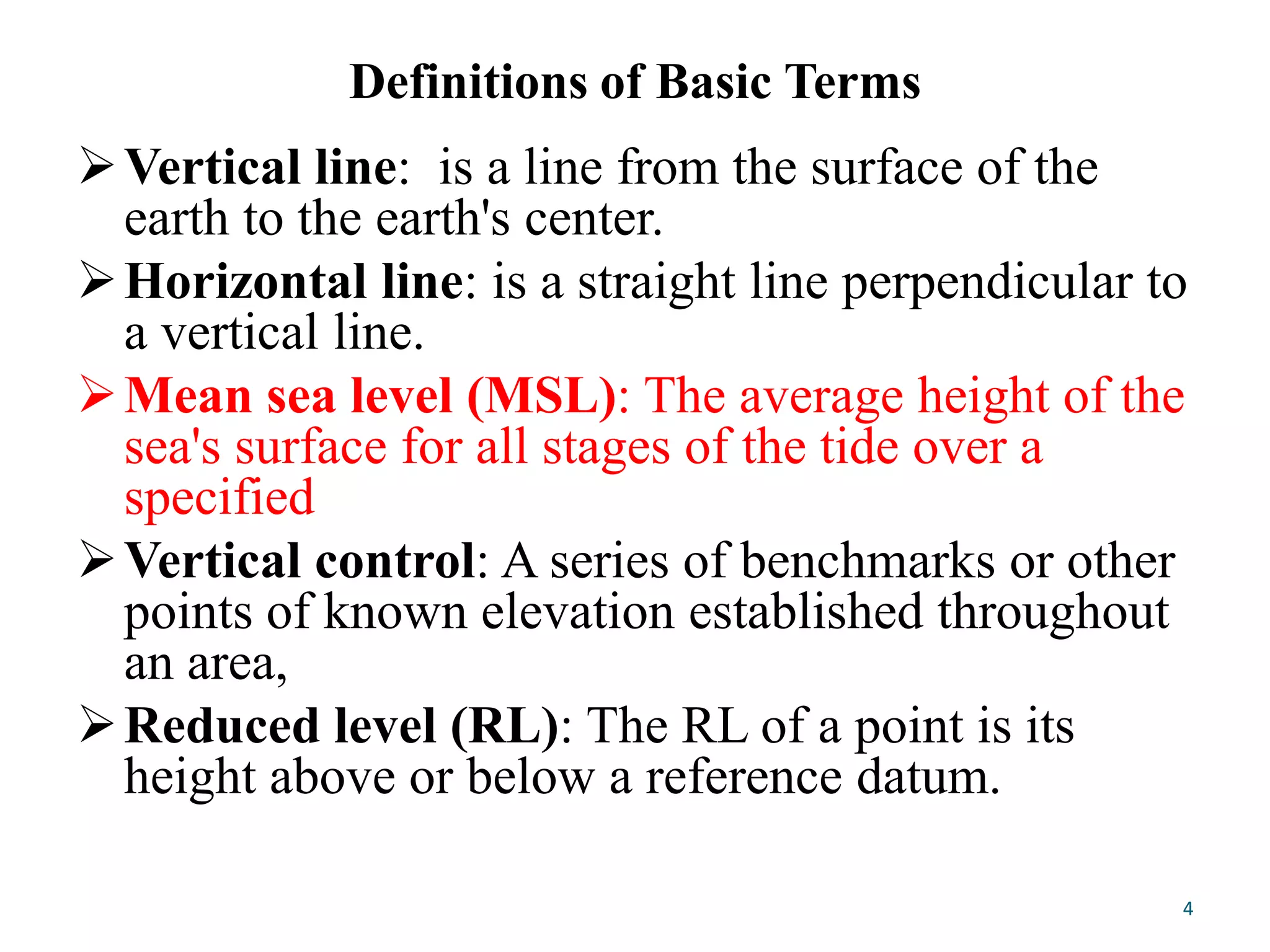
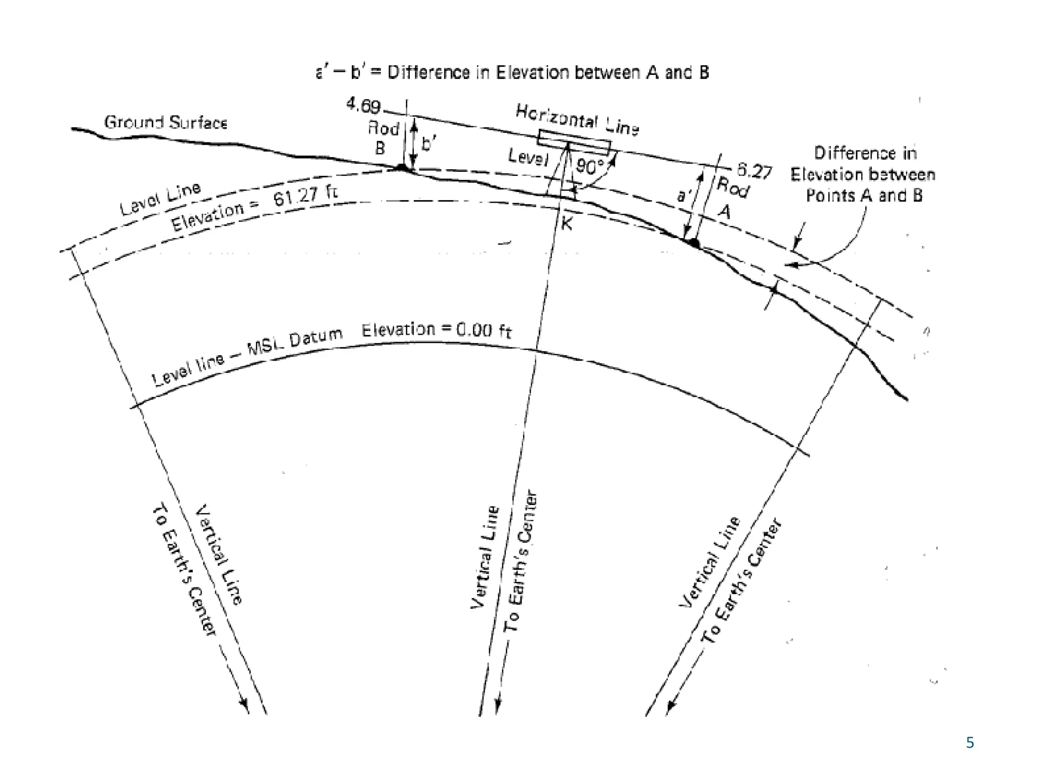
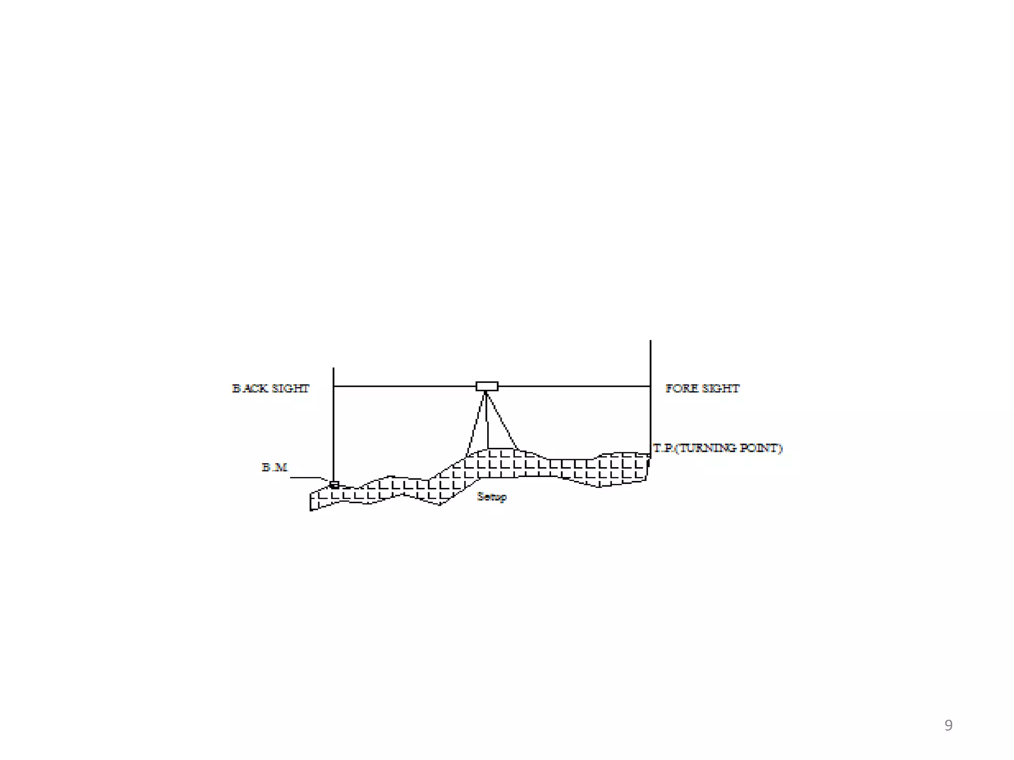
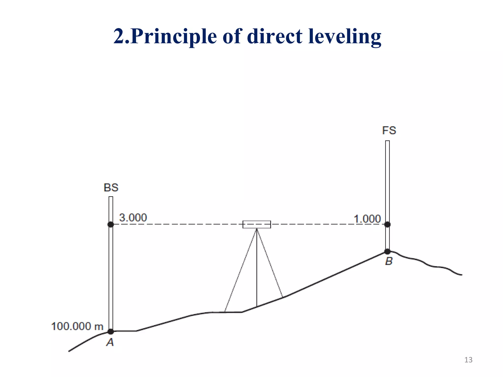
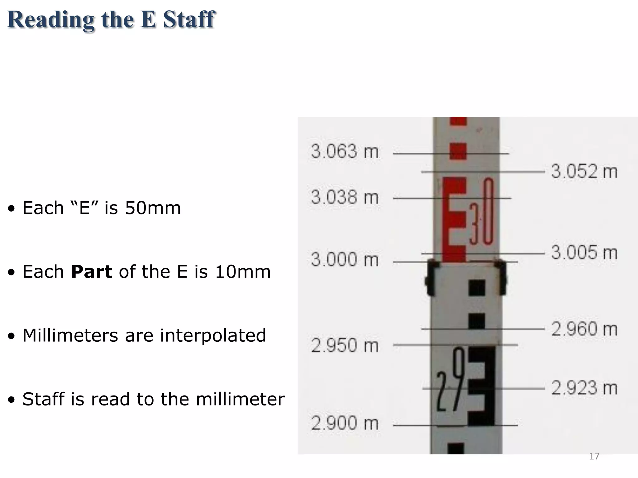
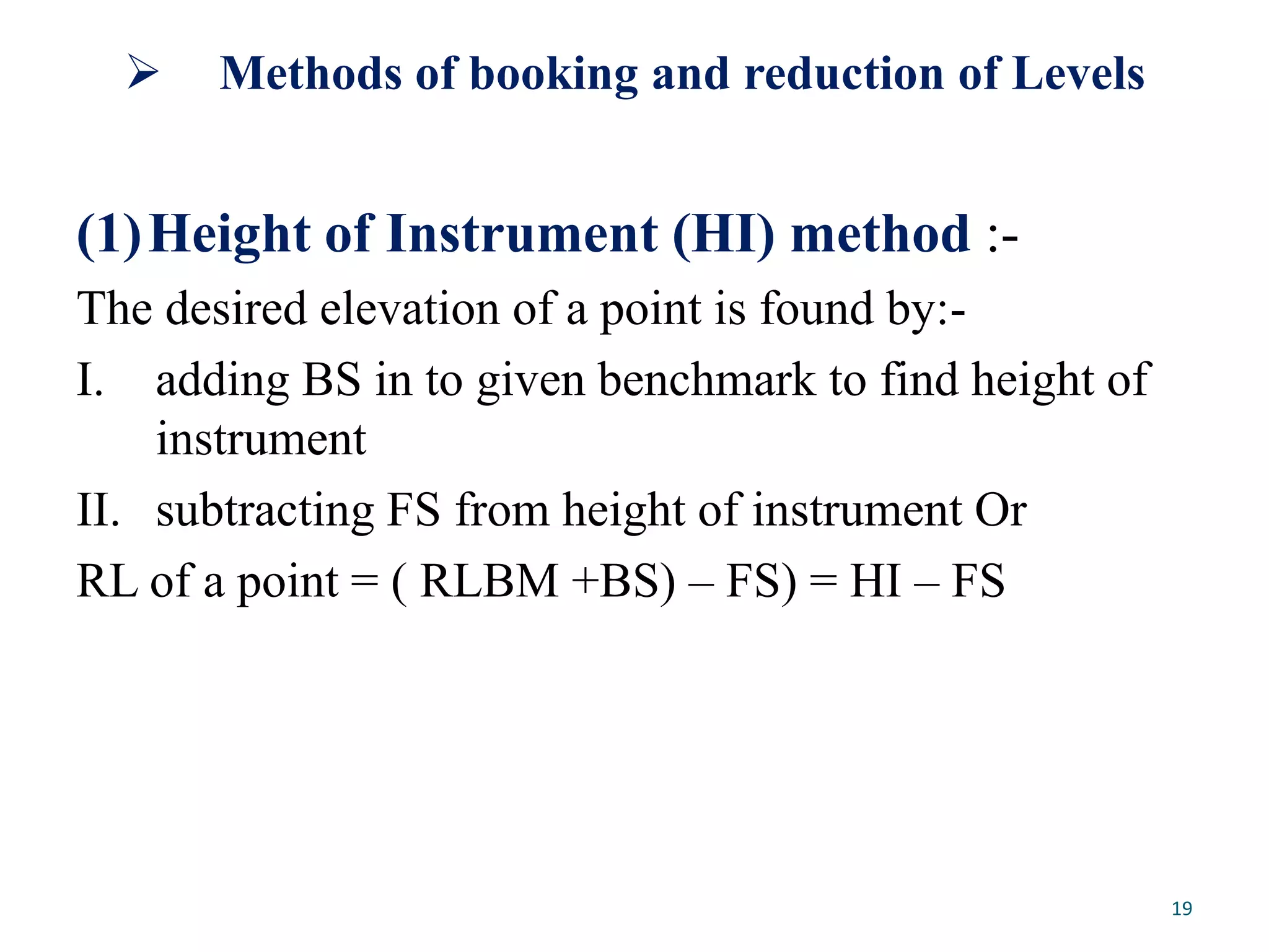
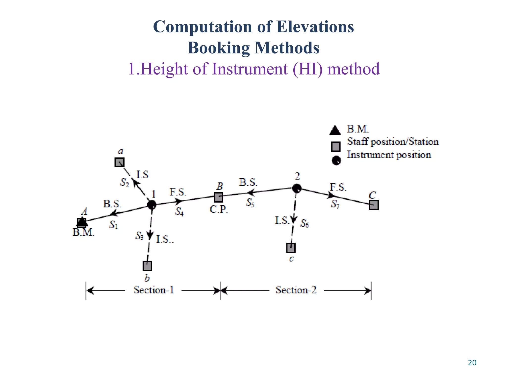
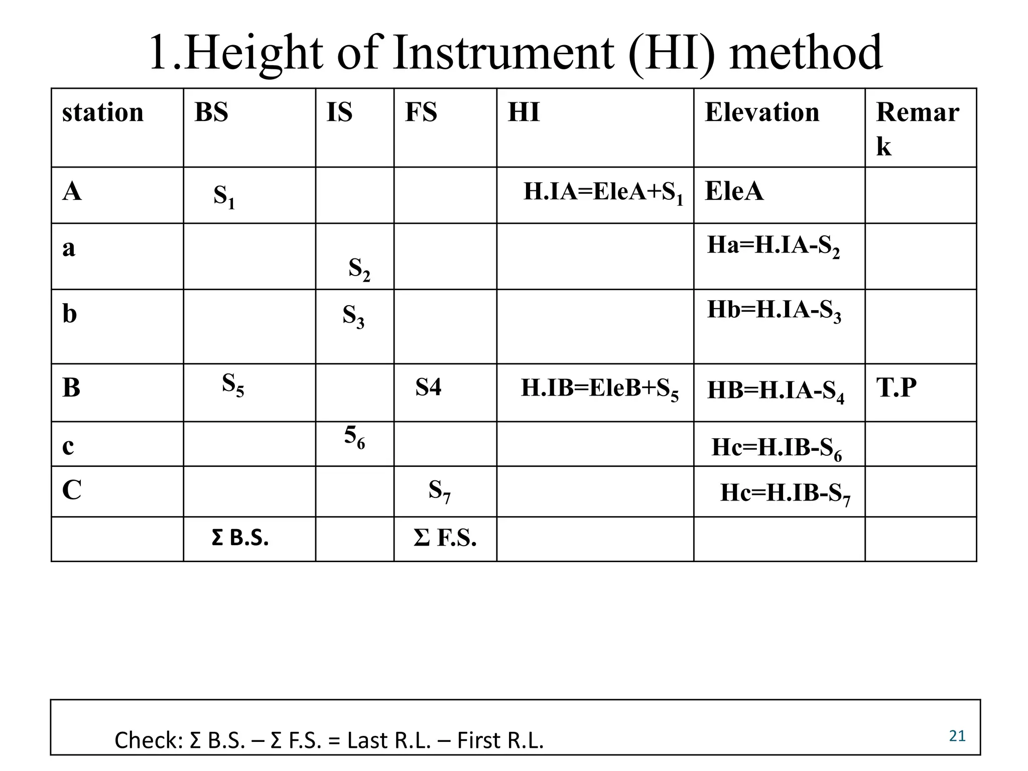
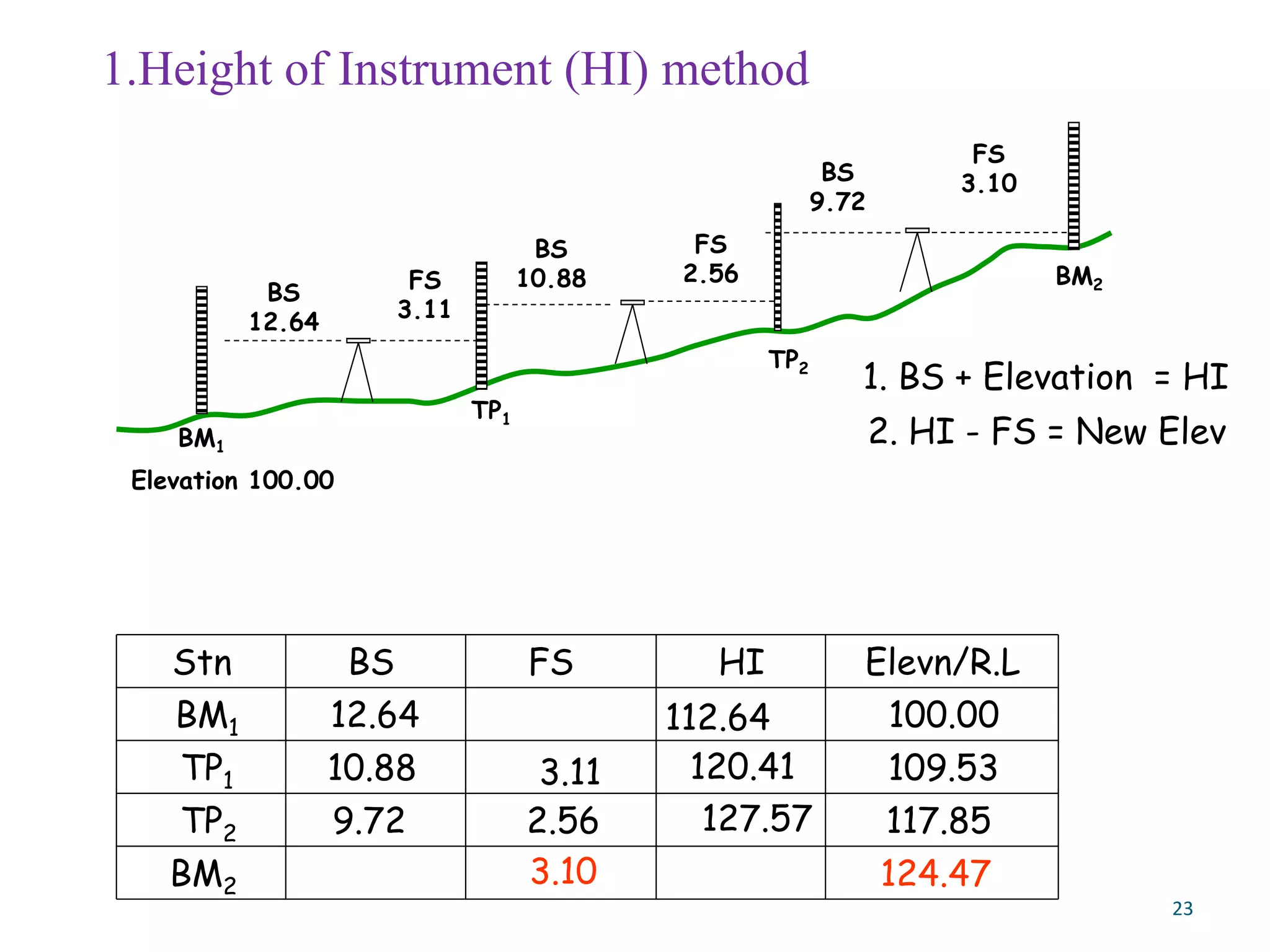
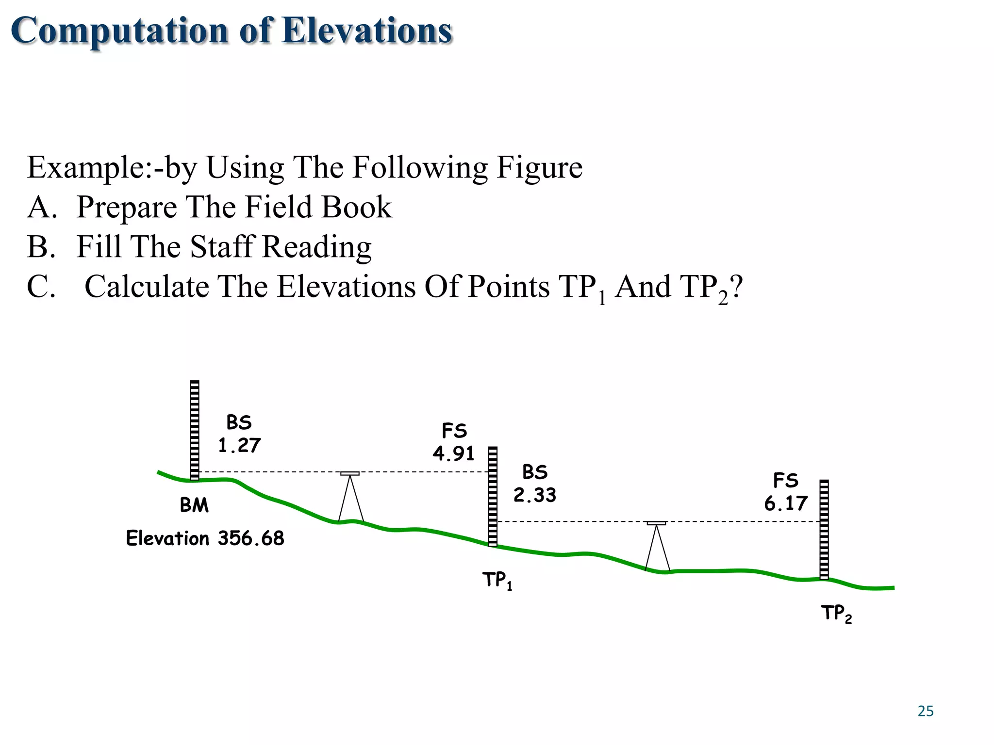
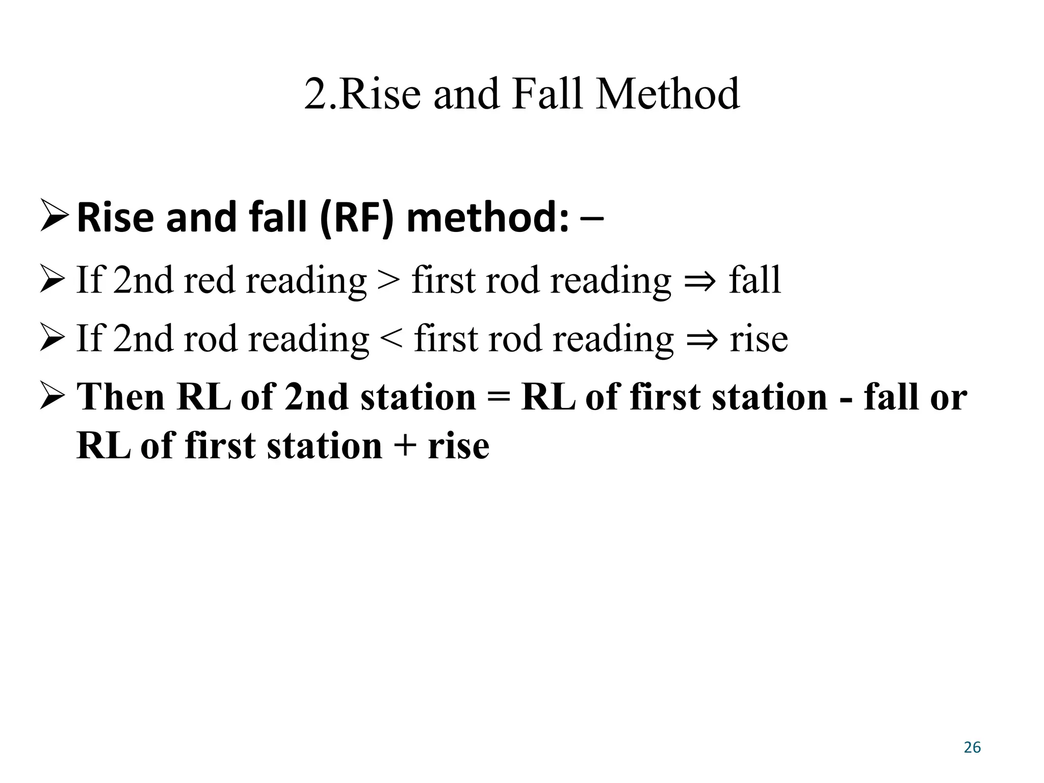
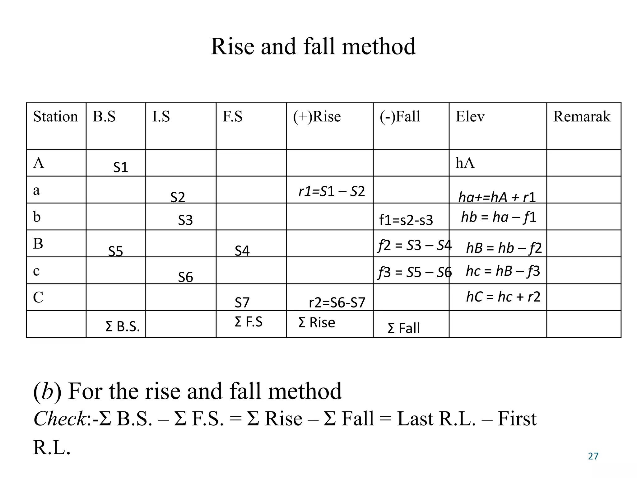
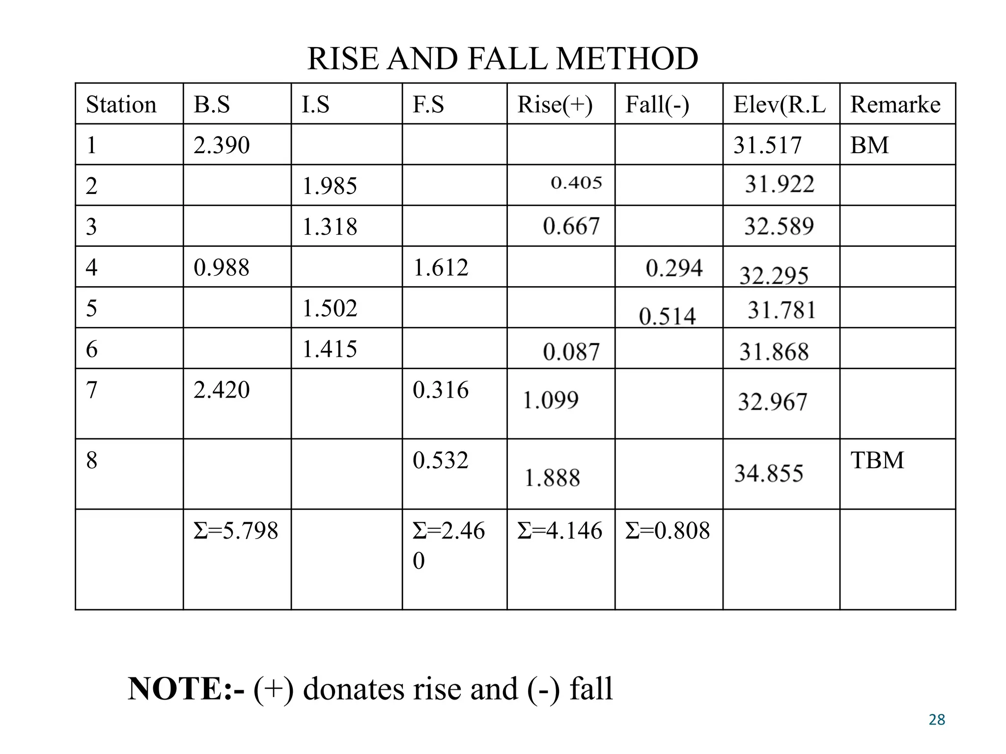
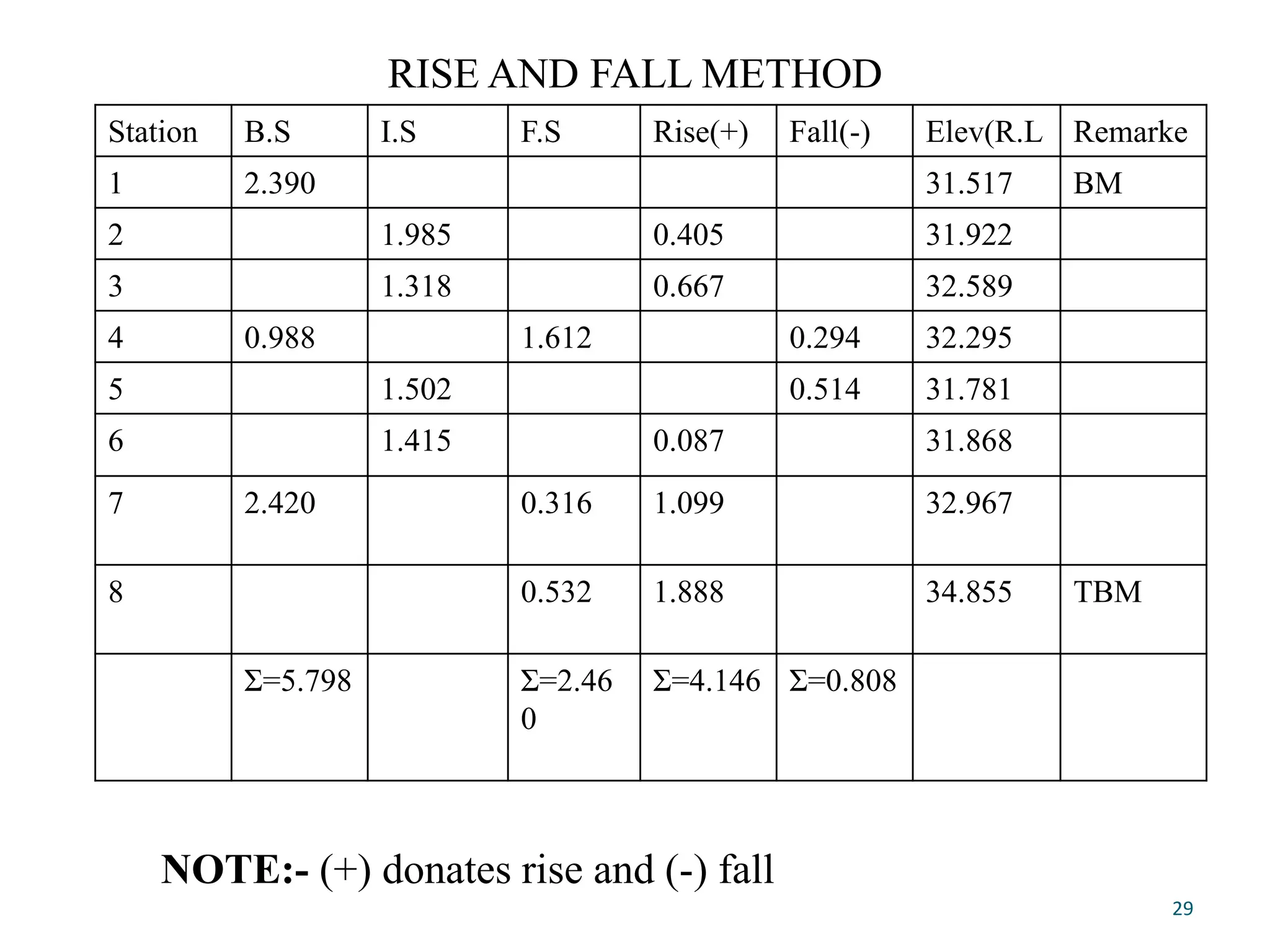
This document describes leveling, which is a surveying method used to determine elevation differences between points. It defines key leveling terms like benchmark, backsight, foresight, and introduces two common leveling booking methods - height of instrument and rise and fall. Height of instrument determines elevations by adding/subtracting staff readings to the known elevation or last benchmark. Rise and fall codes elevations increases as rises and decreases as falls to track changes in elevation from one point to the next. The document provides examples of how to record leveling data and compute elevations using each method.
Course Contents:
Introduction; Linear measurements; Analysis and adjustment of measurements, Survey methods: coordinate systems, bearings, horizontal control, traversing, triangulation, detail surveying; Orientation and position; Areas and volumes; Setting out; Curve ranging; Global Positioning system (GPS); Photogrammetry.
Conventional and modern surveying instrumentssameedaslam
Instruments have a major importance in the field of survey. There are numerous instruments which are used in surveying.With the passage of time instruments have been modified and more accurate.
The science of today is the technology of tomorrow.
surveying Engineering
Fly Levelling
Fly leveling: -Fly leveling is just like differential leveling carried
out to check the accuracy of leveling work. It is a very approximate
form of leveling in which sights are taken as large as possible. in this
method, a line of levels is run to determine approximately reduced
levels of the points carried out with more rapidly and less precision
The aim of fly Levelling: The main purpose of this type of leveling is
to check the values of the reduced levels of the bench marks already
fixed. In this method only back sight and foresight are taken. There is no need of intermediate sights. However great care has to be taken for selecting the change points (Turning Points) and for taking reading on the change points because the accuracy of leveling depends upon these
-Create Bench Marks (BM).
Bench Marks
Bench Mark is a point of known elevation, there are three Type of Bench Marks
1-Perment Bench Mark.
2-Orbitrary Bench Mark .
3-Temporary Bench Mark .
-Leveling Process Calculation.
1. Height of collimation method
2. Rise and Fall method
How do we find horizontal distance using levelling Machine.
Fly Levelling Close loop survey.
Fly and Differential leveling Using (Rise & fall) and (HI)methods.
*Checks for Errors
-Misclosure
Allowable closing error
Where:
D =Distance in km
E = Misclosure error in (mm).
C = 30 for fixed levelling process in rough ground.
C = 15 for normal leveling in flat area (Good work)
Fly Levelling example
Computation of Elevations for an open loop survey H.I method
Computation of Elevations
Differential Leveling
Computation of Elevations
-Correction For Errors in Leveling
1. Errors Due to the line of sight being not horizontal
2. Error Due to Curvature and refraction.
Errors in differential leveling: -
1) Non adjustment of the instrument: -
a) Adjustment of cross-wire ring
b) Adjustment of the bubble tube
c) Adjustment of line of sight
2-Errors in levelling
• Collimation line
• Parallax
• Change point instability
• Instrument instability
• Benchmark instability
• Staff reading errors , • Staff verticality • Level Instrument shading • Temperature on staff • Booking errors) • Earth curvature • Refraction • The Bubble not center.
3-Constant error (instrumental error):
A. Non vertically of the staff.
B. Collimation error in the instrument.
C. Staff gradation error.
4- Random error (natural error):
A. Effect of wind and temperature.
B. Soft and hard ground.
C. Change points. CP
D. Human deficiencies and neglect
Prepared by:
Asst. Prof. Salar K.Hussein
Mr. Kamal Y.Abdullah
Asst.Lecturer. Dilveen H. Omar
Erbil Polytechnic University
Technical Engineering College
Civil Engineering Department
In this lecture we will cover
Applications of levelling
Equipment and procedures
Purposes of levelling
Some definitions
Applications
Longitudinal sections and cross sections
Plotting the profile
Procedure of profile
Procedure of cross-section:
Plotting the cross-section:
Prepared by:
Asst. Prof. Salar K.Hussein
Mr. Kamal Y.Abdullah
Asst.Lecturer. Dilveen H. Omar
Erbil Polytechnic University
Technical Engineering College
Civil Engineering Department
Introduction to Surveying LEVELLING PROCEDURESBahzad5
Introduction to Surveying LEVELLING PROCEDURES
Review of levelling
• In this lecture we will cover :
Equipment and procedures
Purposes of levelling
Some definitions
Reading a staff
Temporary adjustment of level
Booking and reduction
Methods of booking
Applications
Leveling:-
Leveling defined as an operation for the measurement of the
difference in the elevation between points or for the determination
of the elevation of certain points above some given plane or
surface known as the datum surface , generally is taken as the
mean sea level (M S L)
Leveling
Is a type of surveying which is carried out for finding difference in
heights in engineering projects. Leveling is required for various
purposes such as for
calculation of the depth of cutting and fillings, for setting out
grades for sewerage and pipe lines, etc.
Types of Leveling and Application
I. Direct Methods :
II. Indirect Leveling
1. Simple Levelling .
2. Compound Levelling or Differential Levelling.
3.Flying Levelling.
4-Contours map
5. Longitudinal or profile Levelling.
6. Cross-section Levelling.
7.Reciprocal Levelling.
8-Precise Levelling.
Level instrument
Types of Level Instruments & Parts of level instrument
1. Dumpy Level
2. Tilting Level
3. Automatic Level
4. Electronic Level
5. Hand Level
6-Digital level
-Temporary adjustment of level.
-The procedure is repeated.. till the bubble remains in the center in both the positions.
-Leveling staves
*Types of Staff (Rod).
Reading Staff.
What is Leveling?
Prepared by:
Asst. Prof. Salar K.Hussein
Mr. Kamal Y.Abdullah
Asst.Lecturer. Dilveen H. Omar
Erbil Polytechnic University
Technical Engineering College
Civil Engineering Department
Book Formatting: Quality Control Checks for DesignersConfidence Ago
This presentation was made to help designers who work in publishing houses or format books for printing ensure quality.
Quality control is vital to every industry. This is why every department in a company need create a method they use in ensuring quality. This, perhaps, will not only improve the quality of products and bring errors to the barest minimum, but take it to a near perfect finish.
It is beyond a moot point that a good book will somewhat be judged by its cover, but the content of the book remains king. No matter how beautiful the cover, if the quality of writing or presentation is off, that will be a reason for readers not to come back to the book or recommend it.
So, this presentation points designers to some important things that may be missed by an editor that they could eventually discover and call the attention of the editor.
Hello everyone! I am thrilled to present my latest portfolio on LinkedIn, marking the culmination of my architectural journey thus far. Over the span of five years, I've been fortunate to acquire a wealth of knowledge under the guidance of esteemed professors and industry mentors. From rigorous academic pursuits to practical engagements, each experience has contributed to my growth and refinement as an architecture student. This portfolio not only showcases my projects but also underscores my attention to detail and to innovative architecture as a profession.
Between Filth and Fortune- Urban Cattle Foraging Realities by Devi S Nair, An...Mansi Shah
This study examines cattle rearing in urban and rural settings, focusing on milk production and consumption. By exploring a case in Ahmedabad, it highlights the challenges and processes in dairy farming across different environments, emphasising the need for sustainable practices and the essential role of milk in daily consumption.
Unleash Your Inner Demon with the "Let's Summon Demons" T-Shirt. Calling all fans of dark humor and edgy fashion! The "Let's Summon Demons" t-shirt is a unique way to express yourself and turn heads.
https://dribbble.com/shots/24253051-Let-s-Summon-Demons-Shirt
1. CHAPTER THREE
VERTICAL DISTANCEMEASUREMENT( LEVELING)
1
Content :-
Introduction
Definitions of Basic Terms
Principle of leveling
The Leveling Instrument
Booking Methods of Leveling and Reduction of
Levels
Types of Leveling
Errors in leveling
Engineering application of leveling
2. 3.1 Introduction
Leveling is a method of surveying used for determination
of the difference of elevations or
Levels of various points on the surface of the earth.
The elevation of a point is its vertical distance above or
below a reference level, called datum.
The most commonly used datum is the mean sea Level
(M.S.L)
2
3. Leveling is an important
for many engineering works and
construction projects.
Leveling is needed for the design of highways,
railways, and canals e.t.c and for locating the gradient
lines.
3
4. Definitions of Basic Terms
Vertical line: is a line from the surface of the
earth to the earth's center.
Horizontal line: is a straight line perpendicular to
a vertical line.
Mean sea level (MSL): The average height of the
sea's surface for all stages of the tide over a
specified
Vertical control: A series of benchmarks or other
points of known elevation established throughout
an area,
Reduced level (RL): The RL of a point is its
height above or below a reference datum.
4
6. 3.2 Definitions of Basic Terms
1.Station.The station is the point where the staff is held for taking reading
(observation) from a leveling instrument.
2. Bench mark (BM): -is a permanent or semi permanent point of known
elevation that provides beginning point for determining the elevation of
other points.
3.Height of the instrument. (H.I). It is the elevation of the line of sight
with respect to the datum.
The elevation of the line of sight of the telescope
6
7. 4.Backsight (BS) - It is the reading taken
on a staff held at point of known elevation or
at the point whose elevation has already been determined.
The reading taken after setting the instrument set up(the first reading)
5.Foresight (FS) - The last sight taken before the instrument is moved
7
Definitions of Basic Terms …
8. 6.Intermediate sight (IS) - It is the reading taken on a staff held
at point whose elevations is required,
Any sighting that is not a back sight or fore sight
7. Line of Collimation – Imaginary line that passes through
leveling instrument at Cross-Hairs .
8.Turning point. (T.P.) :-For leveling over a long distance, the
instrument has to be set up a number of times.
• A turning point is the point selected on the route before
shifting the instrument.
8
Definitions of Basic Terms …
10. 9. Balancing of sight. To reduce the effect of
instrumental and other errors, the distance of the point
where a back sight is taken and the distance of the point
where a fore sight is taken, as measured from the
instrument station, should be approximately equal.
10
11. 2.Steps in leveling
1. When the leveling instrument has been properly
leveled, the bubble tube axis and the line of sight are
horizontal and the vertical axis of the instrument is
truly vertical.
2. In practice, the leveling instrument is set up at a
convenient position, and the one staff is kept at a
point of known elevation.
3. The reading is taken on the staff and the level of the
line of sight is determined.
11
12. 4. Now the 2nd staff is kept on the point of the
unknown elevation and a reading is taken.
5. The level of the point is determined from the level
of the line of sight already computed and from the
2nd staff reading.
12
14. The Leveling Instrument
The Level
dumpy levels, tilting levels, and automatic levels
Has a set of cross-hairs
Can be turned through 360° horizontally
Consist of a high-powered telescope
Attached to a spirit or bubble level that keeps the line of sight of the
telescope horizontal
14
15. The Tripod:- A fully adjustable 3-legged stand on which
the level sits.
15
16. The Staff
A measuring stick, usually 4m tall, and clearly marked in
divisions of 10mm.
16
17. Reading the E Staff
• Each “E” is 50mm
• Each Part of the E is 10mm
• Millimeters are interpolated
• Staff is read to the millimeter
17
18. Bubble
Keep the staff upright
Any tilt will disturb your readings
18
19. Methods of booking and reduction of Levels
(1)Height of Instrument (HI) method :-
The desired elevation of a point is found by:-
I. adding BS in to given benchmark to find height of
instrument
II. subtracting FS from height of instrument Or
RL of a point = ( RLBM +BS) – FS) = HI – FS
19
21. 1.Height of Instrument (HI) method
station BS IS FS HI Elevation Remar
k
A EleA
a
b
B T.P
c
C
21
S1
S2
S3
S4
S5
56
S7
H.IA=EleA+S1
Ha=H.IA-S2
Hb=H.IA-S3
HB=H.IA-S4
Hc=H.IB-S7
H.IB=EleB+S5
Hc=H.IB-S6
Σ B.S. Σ F.S.
Check: Σ B.S. – Σ F.S. = Last R.L. – First R.L.
24. Change in elevation:
summation of the BS and the FS then subtract
+33.24 -8.77
Change in elevation = 33.24 -8.77 = 24.47
Point
BM1
TP1
Elevation
BS FS HI
12.64 112.64
3.11 109.53
10.88 120.41
2.56
TP2 117.85
9.72 127.57
BM2
3.10 124.47
100.00
ΣΔh = BM2Elev – BM1elev
= ΣBS – ΣFS
24
25. Computation of Elevations
Example:-by Using The Following Figure
A. Prepare The Field Book
B. Fill The Staff Reading
C. Calculate The Elevations Of Points TP1 And TP2?
BS
1.27
FS
4.91
TP1
BM
BS
2.33
FS
6.17
TP2
Elevation 356.68
25
26. 2.Rise and Fall Method
Rise and fall (RF) method: –
If 2nd red reading > first rod reading ⇒ fall
If 2nd rod reading < first rod reading ⇒ rise
Then RL of 2nd station = RL of first station - fall or
RL of first station + rise
26
27. Rise and fall method
Station B.S I.S F.S (+)Rise (-)Fall Elev Remarak
A hA
a
b
B
c
C
27
S1
S2
S3
S4
S5
S6
r1=S1 – S2
f2 = S3 – S4
f1=s2-s3
f3 = S5 – S6
r2=S6-S7
ha+=hA + r1
hb = ha – f1
hB = hb – f2
hc = hB – f3
hC = hc + r2
(b) For the rise and fall method
Check:-Σ B.S. – Σ F.S. = Σ Rise – Σ Fall = Last R.L. – First
R.L.
S7
Σ B.S. Σ F.S Σ Rise Σ Fall
28. RISE AND FALL METHOD
Station B.S I.S F.S Rise(+) Fall(-) Elev(R.L Remarke
1 2.390 31.517 BM
2 1.985
3 1.318
4 0.988 1.612
5 1.502
6 1.415
7 2.420 0.316
8 0.532 TBM
Σ=5.798 Σ=2.46
0
Σ=4.146 Σ=0.808
28
NOTE:- (+) donates rise and (-) fall