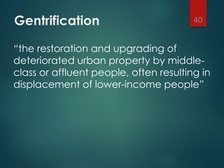
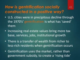
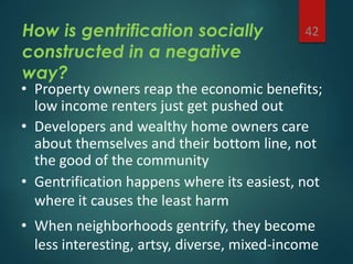
Urban
Geography
INDUSTRIAL REVOLUTION
URBANIZATION
SUBURBANIZATION
URBAN DESIGN
1
Natasha Boyde
May 4, 2015
Going way back…
 8th c. BC “planning” in the Roman Empire:
2
Pompeii (from wikipedia)
from history.co.uk
from historylink102.com
“All Roads Lead to Rome”
Physical planning, construction as an expression and consolidation of power
The power of planning to
order, organize, enable
civilization
 Roads
 Ports
 Aqueducts
 Fortifications/Boundaries
 Common Spaces (Agora, Forum, Baths, Shrines)
3
While most of the world remained rural, agricultural – ‘urban’ nodes served as centers
Transcontinental power
• Constantinople is a controlled trade point
between East and West
• Black Sea & Mediterranean Sea connect
Europe to Asia, N. Africa
Ottoman Empire 1299 – 1923 4
Colonial, pre-Civil War US:
an agricultural nation
5
Eastern seaboard cities
served as centers of
commerce, trade; in 1800
most citizens (and many
political leaders) were
farmers
Industrialization (1800-1900s)
Industrial Revolution – Britain, then United States
Began with transportation (steam) then moved to industry and
manufacturing (steel)
-urban nodes and settlement patterns -railroad and sea ports
-“3 mile city” -urban growth / urbanization
Industry rose from late 1800s to early 1900s
Connecticuthistory.org ushistoryscene.com
‘urban’ centers have been around for millennia…
‘urbanization’ has taken hold in the last 150 years.
 So what is urbanization? Why did it intensify so dramatically?
 “the proportion of the total population concentrated in urban
settlements” (Kingsley Davis, 1965 “The Urbanization of the Human
Population”
7
Hulton Deutsch, encarta.msn.com
1800
Total US pop:
5 million
Urban pop:
300,000
6% urbanized
1900
Total US pop:
76 million
Urban pop:
30 million
40% urbanized
As overall population and manufacturing grew, cities became larger and denser
(Hammond, 1968)
(Sugrue 1998)(Sugrue 1998)
(Sugrue 1998)
Factors at work in US
urbanization:
10
• Population growth (i.e. reproduction)
• Increased agricultural production
• New modes of factory production
• Cheap transportation (steamship, railroad)
• Water as a resource: port cities, river cities
• Immigration
While we are now more urbanized than ever before, we have never again seen
population densities as high as US cities of the late 19th c. (Levy p 11)
Urban Conditions in late 19th c.
America
 “3 mile radius” – the distance someone can
walk in an hour
11
Factories, ports employ millions of workers; they all need to live within 3 miles
From Little Italy Neighbors’ Association (LINA)
From Jacob Riis, How the Other Half Lives (1890)
Sanitary Reform =
Beginning of American
Urban Planning
 American industrial cities faced severe public health threats
due to their unsanitary living conditions
12
• Human waste became a serious problem due
to crowding, and a lack of dedicated sewers
Up to 2,000 people
per acre
(Levy p12)
“private” privies in
apartment yards,
and/or dumping in the streets
(Peterson p15)
Living conditions in factory slums became intolerable, and disease epidemics took hold
19th c. -- beginnings of
government involvement
• housing reform – 1867 NYC legislation
regulating tenement construction
• Public water supply and water-sewer carriage
– widespread implementation in the 1870’s
Note that at its inception – from its inception, and ongoing –
the American planning tradition has been reactive, not proactive
Garden Cities
 Major advocates:
Patrick Geddes (“survey, then plan”)
Ebenezer Howard (Garden Cities of To-Morrow)
appropriate spatial form determines social organization, quality of life
Urban Design
 Architects who think big
 Planners who think small
 Landscape architects focused on connections
 Interdisciplinary notion, central tenets are that
urban form matters (volume, space); and that
meso-scale matters (between the macro of
regions, cities and the micro of individual
buildings)
Haussmann’s
Paris
 Broad avenues
 Arrondissements
 The spatial
expression of a new
political regime –
Napoleon III –
“modern,
functional, rational”
Haussmann
boulevards remain
the backbone of
Paris spatial
organization
“A little bit of Paris in Philly”
Highly questionable as a successful public space
Other big names in
critical/constructive urban
design theory…
• Jane Jacobs, The Death and Life of Great
American Cities(1962)
• William H. Whyte, The Social Life of Small
Urban Spaces (1980)
https://vimeo.com/111488563
Urban Design and Public
Space
“the city is a theater of social action, and
an aesthetic symbol of collective unity”
Lewis Mumford, What is a City?, p 94
But who has a right to this space??
The Militarization of Urban Space
Presidio Modelo Prison, Cuba 2005
The Panopticon prison design
translated into urban design
-Surveillance in Public Space
-”The Panopticon Mall”
Jeremy Bentham’s Panopticon
The Panopticon Mall
The Militarization of Urban
Space
Who has a right to urban spaces for
what kinds of uses?
• Weeding out the “undesirables”
1990
2003
SF bus stop seats
The Militarization of Urban Space
Suburbanization (c. 1950s)
Automation = decline in manufacturing jobs available
labor surplus
Car Culture & Freeways
Affordable housing & property taxes
Higher standard of living
Decentralization
those who could leave did
increasing job opportunities
left low-skilled, low-mobility, low SES in the city
(Sugrue 1998)
What fed the frenzy?
Things that fed the phenomenon:
Roads
Zoning
Mortgages
Baby Boom
For half of the American population, up and out of the cities
Construction Methods
1908-1927: “Tin Lizzie”
1915:
5 million cars
In the US
1930:
25 million cars
In the US
By 1927, there was one car for every 5 Americans, or roughly 1 for every 2 families
Highways bought growth
Photos courtesy of Arroyo Seco Parkway Corridor plan
• Robert Moses and the greater New York parkway system
• The Pennsylvania Turnpike from Harrisburg to Pittsburgh, PA
• The Pasadena Freeway, Los Angeles County, CA
Planned Communities BASED ON
the automobile
City Beautiful meets Garden Cities meets Henry Ford meets the American real estate market
Frank Lloyd Wright’s Broadacre City
• Beverly Hills, 1914
• Palos Verdes Estates, 1923
• Radburn, 1929
Decentralized, democratic, pioneering vision
Anti-urban; city as cancerous, city as prison
Individualist emphasis
Access to space, privacy for middle class
homeowners
World War II
1920’s auto-oriented suburbanization trends…
post
… on crack
Highway Construction
 The Federal-Aid Highway Act of 1956, aka
National Interstate and Defense Highways Act
The American Dream,
c.1950
Deindustrialization
(1950s-1980s)
Declines in manufacturing were occurring as early
as 1930s
Declines due to automation occurred on a massive
scale, now coupled with outsourcing
Rust Belt – 1980s
(Hammond, 1968)
(Sugrue 1998)
ERIEP (Klier and Rubenstein 2011)
Decline of the Inner City
Decentralizationdisinvestment
Inner-city ghettos
Slum clearance and urban
renewal
White flight and Urban Blight
Images of Detroit 1940 (Sugrue 1998)
How does government go about
spatial planning?
 PUBLIC INVESTMENT. SPENDING
MONEY TO BUILD THINGS; E.G.
ROADS, SCHOOLS, BRIDGES.
FUNDING COMES FROM TAX
REVENUE, DEBT FINANCING.
 Regulation. Requiring compliance
with codes, plans, mandates, targets.
Local governments plan in order to coordinate these activities
within a coherent framework
Revitalization and
Renewal
 Gentrification
 Evictions
 Relocation strategies
 Demolishing housing projects and blighted urban
cores
 Mission Anti-Displacement Coalition
37
Eminent Domain
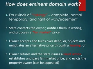
• The power of the state to take appropriate
property for a public use (i.e. revitalize)
• Basis: Fifth Amendment, U.S. Constitution
• Commonly called a taking, a condemnation, or
exapropriation
• Just compensation = fair market value
“…[no person] shall be deprived of life, liberty, or property,
without due process of law; nor shall private property be taken
for public use, without just compensation.”
How does eminent domain work?
 Four kinds of “takings” – complete, partial,
temporary, and right of way/easement
• State contacts the owner, notifies them in writing,
and proposes a “fair market” price
• Owner accepts and turns over deed; or, objects and
negotiates an alternative price through a hearing; or
• Owner refuses and the state issues a court action,
establishes and pays fair market price, and evicts the
property owner (can be appealed)
Gentrification
“the restoration and upgrading of
deteriorated urban property by middle-
class or affluent people, often resulting in
displacement of lower-income people”
40
How is gentrification socially
constructed in a positive way?
41
• U.S. cities were in precipitous decline through
the 1970’s’ gentrification is what has ‘saved’
them
• Increasing real estate values bring more tax
base, services, jobs, institutional growth
• There is a transfer of wealth from richer to
less-rich residents when gentrification occurs
• Gentrification uses the market, rather than
government subsidy, to create a ‘rising tide’
How is gentrification socially
constructed in a negative
way?
42
• Property owners reap the economic benefits;
low income renters just get pushed out
• Developers and wealthy home owners care
about themselves and their bottom line, not
the good of the community
• Gentrification happens where its easiest, not
where it causes the least harm
• When neighborhoods gentrify, they become
less interesting, artsy, diverse, mixed-income
Spanish Harlem
and Brooklyn,
NYC
New Urbanism
 Congress for the New Urbanism (CNU) founded in
1993; Charter ratified in 1996
 “walkable, neighborhood-based development as
an alternative to sprawl” from cnu.org
 Leading figures are architects, designers: Peter
Calthorpe, Andres Duany, Elizabeth Plater-Zyberk,
Elizabeth Moule, Stephanos Polyzoides
What is New Urbanism?
A broad-based call for
 Walkability
 Connectivity
 Mixed use
 Mixed housing
 Quality architecture and urban design
 Neighborhood structure
 Density
 Transportation choices
 Sustainability
 Quality of life
http://www.youtube.com/watch?v=LRrl7LwNUtw
New Urbanism successes
 Gotten more Americans aware of, thinking about
design: do I really want a big house with a big yard
far from work, shopping, schools, friends?
• Shifted the mode of some new “greenfield”
development
• Catalyzed a conversation about transportation,
the implications of our mode of choice
New Urbanism challenges
 Why are we still doing greenfield development,
period? What about brownfields, greyfields?
• Does new urbanism have anything to contribute
to goals like economic equity, diversity?
• Has new urbanist form created stronger
communities? Or is it just appealing to a market
for nostalgia?
• Does new urbanism endorse and promote diverse
values?
What else do we plan for?
 Infrastructure
 Schools, hospitals
 Economic development; sustainability
 Population Growth
 Tax base
What Can be Said of
Urban Planning?
 People use space and place rarely
according to how they’re planned out
 Long-term success?
 Adaptable to technical advances?
 Globalization?
 Climate Change?
Questions?
 Natasha Boyde, MA Geography, CSULB
nats.maps@gmail.com
@consciousmaps
http://consciousmaps.org

LACC Urban Geography Lecture

  • 1.
  • 2.
    Going way back… 8th c. BC “planning” in the Roman Empire: 2 Pompeii (from wikipedia) from history.co.uk from historylink102.com “All Roads Lead to Rome” Physical planning, construction as an expression and consolidation of power
  • 3.
    The power ofplanning to order, organize, enable civilization  Roads  Ports  Aqueducts  Fortifications/Boundaries  Common Spaces (Agora, Forum, Baths, Shrines) 3 While most of the world remained rural, agricultural – ‘urban’ nodes served as centers
  • 4.
    Transcontinental power • Constantinopleis a controlled trade point between East and West • Black Sea & Mediterranean Sea connect Europe to Asia, N. Africa Ottoman Empire 1299 – 1923 4
  • 5.
    Colonial, pre-Civil WarUS: an agricultural nation 5 Eastern seaboard cities served as centers of commerce, trade; in 1800 most citizens (and many political leaders) were farmers
  • 6.
    Industrialization (1800-1900s) Industrial Revolution– Britain, then United States Began with transportation (steam) then moved to industry and manufacturing (steel) -urban nodes and settlement patterns -railroad and sea ports -“3 mile city” -urban growth / urbanization Industry rose from late 1800s to early 1900s Connecticuthistory.org ushistoryscene.com
  • 7.
    ‘urban’ centers havebeen around for millennia… ‘urbanization’ has taken hold in the last 150 years.  So what is urbanization? Why did it intensify so dramatically?  “the proportion of the total population concentrated in urban settlements” (Kingsley Davis, 1965 “The Urbanization of the Human Population” 7 Hulton Deutsch, encarta.msn.com 1800 Total US pop: 5 million Urban pop: 300,000 6% urbanized 1900 Total US pop: 76 million Urban pop: 30 million 40% urbanized As overall population and manufacturing grew, cities became larger and denser
  • 8.
  • 9.
  • 10.
    Factors at workin US urbanization: 10 • Population growth (i.e. reproduction) • Increased agricultural production • New modes of factory production • Cheap transportation (steamship, railroad) • Water as a resource: port cities, river cities • Immigration While we are now more urbanized than ever before, we have never again seen population densities as high as US cities of the late 19th c. (Levy p 11)
  • 11.
    Urban Conditions inlate 19th c. America  “3 mile radius” – the distance someone can walk in an hour 11 Factories, ports employ millions of workers; they all need to live within 3 miles From Little Italy Neighbors’ Association (LINA) From Jacob Riis, How the Other Half Lives (1890)
  • 12.
    Sanitary Reform = Beginningof American Urban Planning  American industrial cities faced severe public health threats due to their unsanitary living conditions 12 • Human waste became a serious problem due to crowding, and a lack of dedicated sewers Up to 2,000 people per acre (Levy p12) “private” privies in apartment yards, and/or dumping in the streets (Peterson p15) Living conditions in factory slums became intolerable, and disease epidemics took hold
  • 13.
    19th c. --beginnings of government involvement • housing reform – 1867 NYC legislation regulating tenement construction • Public water supply and water-sewer carriage – widespread implementation in the 1870’s Note that at its inception – from its inception, and ongoing – the American planning tradition has been reactive, not proactive
  • 14.
    Garden Cities  Majoradvocates: Patrick Geddes (“survey, then plan”) Ebenezer Howard (Garden Cities of To-Morrow) appropriate spatial form determines social organization, quality of life
  • 15.
    Urban Design  Architectswho think big  Planners who think small  Landscape architects focused on connections  Interdisciplinary notion, central tenets are that urban form matters (volume, space); and that meso-scale matters (between the macro of regions, cities and the micro of individual buildings)
  • 16.
    Haussmann’s Paris  Broad avenues Arrondissements  The spatial expression of a new political regime – Napoleon III – “modern, functional, rational”
  • 17.
    Haussmann boulevards remain the backboneof Paris spatial organization
  • 18.
    “A little bitof Paris in Philly” Highly questionable as a successful public space
  • 19.
    Other big namesin critical/constructive urban design theory… • Jane Jacobs, The Death and Life of Great American Cities(1962) • William H. Whyte, The Social Life of Small Urban Spaces (1980) https://vimeo.com/111488563
  • 20.
    Urban Design andPublic Space “the city is a theater of social action, and an aesthetic symbol of collective unity” Lewis Mumford, What is a City?, p 94 But who has a right to this space??
  • 21.
    The Militarization ofUrban Space Presidio Modelo Prison, Cuba 2005 The Panopticon prison design translated into urban design -Surveillance in Public Space -”The Panopticon Mall” Jeremy Bentham’s Panopticon
  • 22.
  • 23.
    The Militarization ofUrban Space Who has a right to urban spaces for what kinds of uses? • Weeding out the “undesirables” 1990 2003 SF bus stop seats
  • 24.
  • 25.
  • 26.
    Suburbanization (c. 1950s) Automation= decline in manufacturing jobs available labor surplus Car Culture & Freeways Affordable housing & property taxes Higher standard of living Decentralization those who could leave did increasing job opportunities left low-skilled, low-mobility, low SES in the city (Sugrue 1998)
  • 27.
    What fed thefrenzy? Things that fed the phenomenon: Roads Zoning Mortgages Baby Boom For half of the American population, up and out of the cities Construction Methods
  • 28.
    1908-1927: “Tin Lizzie” 1915: 5million cars In the US 1930: 25 million cars In the US By 1927, there was one car for every 5 Americans, or roughly 1 for every 2 families
  • 29.
    Highways bought growth Photoscourtesy of Arroyo Seco Parkway Corridor plan • Robert Moses and the greater New York parkway system • The Pennsylvania Turnpike from Harrisburg to Pittsburgh, PA • The Pasadena Freeway, Los Angeles County, CA
  • 30.
    Planned Communities BASEDON the automobile City Beautiful meets Garden Cities meets Henry Ford meets the American real estate market Frank Lloyd Wright’s Broadacre City • Beverly Hills, 1914 • Palos Verdes Estates, 1923 • Radburn, 1929 Decentralized, democratic, pioneering vision Anti-urban; city as cancerous, city as prison Individualist emphasis Access to space, privacy for middle class homeowners
  • 31.
    World War II 1920’sauto-oriented suburbanization trends… post … on crack
  • 32.
    Highway Construction  TheFederal-Aid Highway Act of 1956, aka National Interstate and Defense Highways Act
  • 33.
  • 34.
    Deindustrialization (1950s-1980s) Declines in manufacturingwere occurring as early as 1930s Declines due to automation occurred on a massive scale, now coupled with outsourcing Rust Belt – 1980s (Hammond, 1968) (Sugrue 1998) ERIEP (Klier and Rubenstein 2011)
  • 35.
    Decline of theInner City Decentralizationdisinvestment Inner-city ghettos Slum clearance and urban renewal White flight and Urban Blight Images of Detroit 1940 (Sugrue 1998)
  • 36.
    How does governmentgo about spatial planning?  PUBLIC INVESTMENT. SPENDING MONEY TO BUILD THINGS; E.G. ROADS, SCHOOLS, BRIDGES. FUNDING COMES FROM TAX REVENUE, DEBT FINANCING.  Regulation. Requiring compliance with codes, plans, mandates, targets. Local governments plan in order to coordinate these activities within a coherent framework
  • 37.
    Revitalization and Renewal  Gentrification Evictions  Relocation strategies  Demolishing housing projects and blighted urban cores  Mission Anti-Displacement Coalition 37
  • 38.
    Eminent Domain • Thepower of the state to take appropriate property for a public use (i.e. revitalize) • Basis: Fifth Amendment, U.S. Constitution • Commonly called a taking, a condemnation, or exapropriation • Just compensation = fair market value “…[no person] shall be deprived of life, liberty, or property, without due process of law; nor shall private property be taken for public use, without just compensation.”
  • 39.
    How does eminentdomain work?  Four kinds of “takings” – complete, partial, temporary, and right of way/easement • State contacts the owner, notifies them in writing, and proposes a “fair market” price • Owner accepts and turns over deed; or, objects and negotiates an alternative price through a hearing; or • Owner refuses and the state issues a court action, establishes and pays fair market price, and evicts the property owner (can be appealed)
  • 40.
    Gentrification “the restoration andupgrading of deteriorated urban property by middle- class or affluent people, often resulting in displacement of lower-income people” 40
  • 41.
    How is gentrificationsocially constructed in a positive way? 41 • U.S. cities were in precipitous decline through the 1970’s’ gentrification is what has ‘saved’ them • Increasing real estate values bring more tax base, services, jobs, institutional growth • There is a transfer of wealth from richer to less-rich residents when gentrification occurs • Gentrification uses the market, rather than government subsidy, to create a ‘rising tide’
  • 42.
    How is gentrificationsocially constructed in a negative way? 42 • Property owners reap the economic benefits; low income renters just get pushed out • Developers and wealthy home owners care about themselves and their bottom line, not the good of the community • Gentrification happens where its easiest, not where it causes the least harm • When neighborhoods gentrify, they become less interesting, artsy, diverse, mixed-income
  • 44.
  • 45.
    New Urbanism  Congressfor the New Urbanism (CNU) founded in 1993; Charter ratified in 1996  “walkable, neighborhood-based development as an alternative to sprawl” from cnu.org  Leading figures are architects, designers: Peter Calthorpe, Andres Duany, Elizabeth Plater-Zyberk, Elizabeth Moule, Stephanos Polyzoides
  • 46.
    What is NewUrbanism? A broad-based call for  Walkability  Connectivity  Mixed use  Mixed housing  Quality architecture and urban design  Neighborhood structure  Density  Transportation choices  Sustainability  Quality of life http://www.youtube.com/watch?v=LRrl7LwNUtw
  • 47.
    New Urbanism successes Gotten more Americans aware of, thinking about design: do I really want a big house with a big yard far from work, shopping, schools, friends? • Shifted the mode of some new “greenfield” development • Catalyzed a conversation about transportation, the implications of our mode of choice
  • 48.
    New Urbanism challenges Why are we still doing greenfield development, period? What about brownfields, greyfields? • Does new urbanism have anything to contribute to goals like economic equity, diversity? • Has new urbanist form created stronger communities? Or is it just appealing to a market for nostalgia? • Does new urbanism endorse and promote diverse values?
  • 49.
    What else dowe plan for?  Infrastructure  Schools, hospitals  Economic development; sustainability  Population Growth  Tax base
  • 50.
    What Can beSaid of Urban Planning?  People use space and place rarely according to how they’re planned out  Long-term success?  Adaptable to technical advances?  Globalization?  Climate Change?
  • 51.
    Questions?  Natasha Boyde,MA Geography, CSULB nats.maps@gmail.com @consciousmaps http://consciousmaps.org

Editor's Notes

  • #3 Going way back to early urban planning look at ancient Rome. 2500 years ago the Romans had made tremendous technological advances in terms of roadways – surveying, grading, paving, creating a means of connectivity throughout the Empire “All roads lead to Rome” = political dominance in this massive region of the world, contributing to a memorable political power that lasted over 12 centuries~
  • #4 Not just the Roman empire, but later the papacy, monarchies, feudal dynasties used physical land use planning to consolidate power and control movement/sustenance/opportunities --READ-- CONNECTIVITY – not just physical, for transport and commerce, but also irrigation, and especially, places for interchange, meaning-making Planned cities supported, enabled rural agricultural enclaves They also enabled monarchs, popes, feudal lords to shape space in order to consolidate power
  • #5 As civilizations expanded across the Western hemisphere urban nodes were built along ports
  • #7 Industrialization of cities worldwide happened 1800-1900. The Industrial Revolution occurred first in Britain, then in the United States, both within the 1800s. First steam (Connecticuthistory.org), then steel Implications of key institutions on urban growth One of first steampowered trains in the 1800s (connecticuthistory.org) Robert Fulton, the steam engine Expansion West across the United States
  • #8 Obviously with the examples of Rome & Constantinople, urban centers have been around for a very long time. But the process of urbanization has really taken hold in the last 150 years. Urbanization = many definitions. But essentially is “the proportion of the total population concentrated in urban settlements” (Kingsley Davis, 1965). Look at the huge spikes in population in the US over one century. This is before major medical advances or even convenient transport, so a jump like this may not look like much to us now (every couple of years another 1billion population), but at the time this is rapid intensification Part of the reason for rapid expansion in the US is our competition with the UK. About 1820-1870 the industrial revolution in the US was partly a reaction to our strained relations with the UK, whose thriving industry made their commercial goods superior. Eli Whitney’s Cotton Gin, interchangeable parts (1794) FORDISM – standardized production line Francis Lowell, spinning and weaving in one factory TAYLORISM All of this advancement in manufacturing is a key element in explaining urbanization patterns in the US during this time.
  • #9 1830-1860 railroad expansion (ushistoryscene.com) The Cumberland Road, the Erie Canal, railroads, communications networks – all were in the name of trade. The US was a commercial power before we were a military power, and our planning reflects this 1860-1900 Industry (Hammond Inc.) 1920-1960 Industry and Cities (Hammond Inc.)
  • #10 1927 Ford River Rouge Plant Detroit – one of the largest, over 85,000 workers (Sugrue) 1930 - Edgewater, NJ on the Hudson River – Fortune Magazine 1940s Detroit (Sugrue)- West Side of Detroit housed thousands of industrial employees in single-family homes (low-rise city). In the 1940s Detroit was the epicenter of booming industry, especially in car production. This drew thousands more migrants to the opportunities of well-paying, secure jobs. 1954 automated plant (Sugrue) – automation, FodismTaylorism
  • #12 Levy p 13 – tenement photos Totally unregulated living conditions (for the most part – we will talk about early efforts at reform, esp in NYC) You can imagine the orientation of landlords – what to do with the acre I own? Nice home with a barn and a garden for one family? Or cram people like sardines into railroad apartments, 6 stories high People arrive from their distant farms, from native countries across the ocean – with no money at all – and find that factory jobs are not all they were cracked up to be; they work 6 days a week, minimum; they’re barely paid enough to eat; and they quickly get stuck in a ruthless cycle Children went to work; Multiple families lived in the same apartment; Disease and squalor were rampant
  • #14 There is the exception of the municipal improvement movement – the Stockbridge, MA example cited in Levy, dating back to 1853 – but it is important to note that this is really a private, volunteer-driven phenomenon.
  • #15 Between 1910 and 1930 – the growth of the community master plan, some regional planning. Howard’s diagrams and paradigm proposes, emphasizes the idea that appropriate urban design and spatial planning can yield a more desireable life. The “rush to zone” – Levy’s terms – really a way to normalize property development, protect property values Regional plans (RPA, the tri-state plan around Philly) – were driven largely by voluntarism, with little or no “teeth” except inasmuch as they served the interests of powerful local leaders (ie Moses) and would thus be adopted/pursued
  • #17 Arrondissement: a subdivision of a department in France, for purposes of local government administration.
  • #22 The Panopticon is a type of institutional building designed by the English philosopher and social theorist Jeremy Bentham in the late 18th century. The concept of the design is to allow a single watchman to observe (-opticon) all (pan-) inmates of an institution without the inmates being able to tell whether or not they are being watched. Although it is physically impossible for the single watchman to observe all cells at once, the fact that the inmates cannot know when they are being watched means that all inmates must act as though they are watched at all times, effectively controlling their own behaviour constantly. The name is also a reference to Panoptes from Greek mythology; he was a giant with a hundred eyes and thus was known to be a very effective watchman. The design consists of a circular structure with an "inspection house" at its centre, from which the manager or staff of the institution are able to watch the inmates, who are stationed around the perimeter. Bentham conceived the basic plan as being equally applicable to hospitals, schools, sanatoriums, daycares, and asylums, but he devoted most of his efforts to developing a design for a Panopticon prison, and it is his prison which is most widely understood by the term.
  • #23 The Panopticon is a type of institutional building designed by the English philosopher and social theorist Jeremy Bentham in the late 18th century. The concept of the design is to allow a single watchman to observe (-opticon) all (pan-) inmates of an institution without the inmates being able to tell whether or not they are being watched. Although it is physically impossible for the single watchman to observe all cells at once, the fact that the inmates cannot know when they are being watched means that all inmates must act as though they are watched at all times, effectively controlling their own behaviour constantly. The name is also a reference to Panoptes from Greek mythology; he was a giant with a hundred eyes and thus was known to be a very effective watchman. The design consists of a circular structure with an "inspection house" at its centre, from which the manager or staff of the institution are able to watch the inmates, who are stationed around the perimeter. Bentham conceived the basic plan as being equally applicable to hospitals, schools, sanatoriums, daycares, and asylums, but he devoted most of his efforts to developing a design for a Panopticon prison, and it is his prison which is most widely understood by the term.
  • #24 The Panopticon is a type of institutional building designed by the English philosopher and social theorist Jeremy Bentham in the late 18th century. The concept of the design is to allow a single watchman to observe (-opticon) all (pan-) inmates of an institution without the inmates being able to tell whether or not they are being watched. Although it is physically impossible for the single watchman to observe all cells at once, the fact that the inmates cannot know when they are being watched means that all inmates must act as though they are watched at all times, effectively controlling their own behaviour constantly. The name is also a reference to Panoptes from Greek mythology; he was a giant with a hundred eyes and thus was known to be a very effective watchman. The design consists of a circular structure with an "inspection house" at its centre, from which the manager or staff of the institution are able to watch the inmates, who are stationed around the perimeter. Bentham conceived the basic plan as being equally applicable to hospitals, schools, sanatoriums, daycares, and asylums, but he devoted most of his efforts to developing a design for a Panopticon prison, and it is his prison which is most widely understood by the term.
  • #27 Automation-will discuss on the next slide, but briefly—it led to decline in MFG jobs Affordability of cars/price of first Ford car?? Levittown (City Reader) Those with mobility left—those with means and resources, upward mobility to get out
  • #29 Hard to underestimate the effect that this innovation had on land use, circulation patterns within towns and cities, commuter patterns – just about everything The introduction of the assembly line put the auto within reach of a wide range of buyers – not just the very wealthy
  • #30 Cars needed somewhere to be driven, to their potential Towns and cities were becoming congested, dangerous messes (not unlike today – but different – no stop lights, no lanes, mish mash of horses, pedestrians, autos The ‘motorway’ with its dedicated exits was a revelation This early adoption of the motorway spurred planning by civic-minded business leaders – property developers – and public officials You can imagine the impact on land valuation, if a parcel is located near a freeway exit
  • #32 You‘ve got this much-enlarged state apparatus – following the war – and a recovered, then thriving economy – the impact on land use development and urbanization was profound
  • #35 Charts – decline in manufacturing jobs Declines as early as 1930s (even before industry peaked) 1980 assembly plants (European Review of Industrial Economics and Policy – from Klier and Rubenstein 2011) For comparison 1960 Industry and Cities (Hammond Inc.)
  • #36 Decentralization led to disinvestment in the city Inner-city ghettos of joblessness, hopelessness (WJW) In response to the increase of these ghettos were slum clearance and urban renewal projects, which displaced the poor and perpetuated poverty