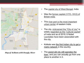
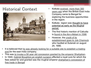
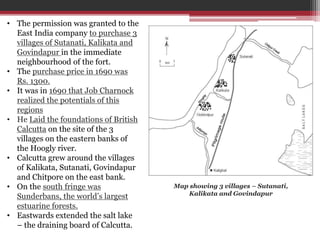
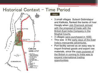
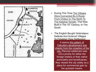
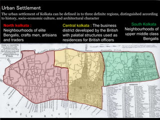
KOLKATA – The City Of Joy
Submitted By:
Moksha Bhatia
M.Arch (Urban Design)
1st - Semester
Introduction
Etymology :
~ Calcutta, ( Bengali Kalikata and
colloquially Kolkata ) – Kali (Goddess
Kali of Kalighat) , and kota – (her
abode).
Location :
• Kolkata is located in the eastern part of
India.
• It has spread linearly along the banks
of Hoogly River.
• The city is near sea level, with the
average elevation being 17 feet.
• Most of the city was originally
marshy wetlands, remnants of which
can still be found especially towards the
eastern parts of the city.
Map of India – showing position of
Kolkata
Map of India – showing position of Kolkata
Map of Kolkata with Hoogly River
• The capital city of West Bengal, India
• Was the former capital (1772 -1912) of
British India.
• This river port is the most important
urban center of eastern India.
• The city, nicknamed the "City of Joy" is
widely regarded as the "cultural capital"
of India and as of 2019, 6 Nobel
Laureates have been associated with
the city.
• Kolkata was the first Indian city to get a
metro network in the country.
• The grand old city still operates the
tram, and you can actually go from one
place to another in it.
Historical Context • Kolkata evolved more than 300
years ago when the British East India
Company came to Bengal for
exploring the business opportunities
in the region.
• Kolkata region was thought to have
potential as early as the Mughal
period.
• The first historic mention of Calcutta
is found in the Ain-i-Akbari in 1596.
• However, the credit of its
establishment goes to Job Charnock
who haulted at Sutanati on august
24, 1690.
• It is believed that he was already looking for a suitable site to establish a trading
port for the east India company.
• This was to invoke a 50 year old concession granted by the emperor Shahjahen.
• In 1640, Gabriel Boughton,an english surgeon effected a royal cure for which the
fees asked for and granted was the mughal emperor shahjehan’s concession of
free trade in Bengal
• The permission was granted to the
East India company to purchase 3
villages of Sutanati, Kalikata and
Govindapur in the immediate
neighbourhood of the fort.
• The purchase price in 1690 was
Rs. 1300.
• It was in 1690 that Job Charnock
realized the potentials of this
regions
• He Laid the foundations of British
Calcutta on the site of the 3
villages on the eastern banks of
the Hoogly river.
• Calcutta grew around the villages
of Kalikata, Sutanati, Govindapur
and Chitpore on the east bank.
• On the south fringe was
Sunderbans, the world’s largest
estuarine forests.
• Eastwards extended the salt lake
– the draining board of Calcutta.
Map showing 3 villages – Sutanati,
Kalikata and Govindapur
Historical Context – Time Period
1690
• 3 small villages Sutauti Gobindapur
and Kalikata, flanked the banks of river
Hoogly when Job Charnock arrived
with the proposal of trade with the
British East India Company in the
Mughal Courts.
• 3 villages were purchased in 1690.
• This was in the early days of the East
India’s mercantile adventures.
• Port facility served as an easy way to
import finished goods and export raw
materials, since the main purpose of
the British in coming to India was to
expand international trading
opportunities.
• During This Time The Villages
Were Connected By A Route
From Chitpur In The North To
The Kalighat Temple, That Was
Built In The 15" Century, In The
South.
• The English Bought Gobindapur,
Kalikata And Sutanuti Villages
To Establish Their Settlement
It seems the pattern of
Calcutta's development was
chaotic from the inception of the
city. Planned settlement was
not a priority for either the
foreign traders or their native
associates and beneficiaries:
they viewed the city solely as a
place for commercial gain by
the quickest means.
• The original Fort was built in the year
1696 by the British East India
Company under the orders of Sir John
Goldsborough
• Fort William was started in 1696 out of
brick duct, lime, molasses and cut
hemp.
• In 1702 construction was completed.
• Fort William was established to protect
the East India Company's trade in the
city of Calcutta
1696
Fort William along River Hoogly
1757
• It was the guardroom of this two-
storied building (Fort William),
where the black hole tragedy took
place.
• During the Plassey war in 1757,
Siraj Ud Daulah, the Nawab of
Bengal attacked on the fort and
defeated the Britishers.
• This paved way for the
construction of a new fort by
British.
• After the battle of Plassey in
1757, the Company started
rebuilding the city.
• The Black Hole of Calcutta was
later used as a warehouse.
• During this time development of
ghats and churches started.
1757 - 1785
• Development of areas – Chowrangi,
Baliganj, Tollyganj, Garden Reach and
Chitpur road.
• Fort William was rebuilt.
• The Fort in 1756, led to Calcutta
acquring its most characteristic feature
– a large open space called Maidan at
the center and Central Business
District roughly placed around it.
• In 1773, the capital was transferred
from Madras to Calcutta.
Maidan
Fort William
• Robert Clive started rebuilding the fort in 1758, after the Battle of Plassey (1757);
construction was completed in 1781 at a cost of approximately two million
pounds.
• The area around the Fort was cleared, and the Maidan became "the Lungs of
Kolkata".
• It stretches for around 3 km in the north-south direction and is around 1 km wide.
• The Old Fort was repaired and used as a customs house from 1766 onwards.
• The basic purpose of setting
up Calcutta Fort William was
to prevent attacks from
Muslim invaders.
• The area that was cleared
around the fort became
maidan, where several
exhibitions and fairs take
place.
Figure shows densification of the city
1785 - 1799
Circular Road
• Maratha Ditch (archaic spelling: Mahratta
Ditch) was a three-mile long moat
excavated around Calcutta (now known as
Kolkata) in Bengal, India, in 1742, as a
protection against possible attacks by
marauding Bargis, as the Marathas were
known locally.
• The road came up on the stretch that
formed the Maratha Ditch that was dug in
1742 to protect the City from the Bargi
invasions.
• The Ditch was never completed which was
excavated to meet the river, and was partly
filled up in 1799 to create the Circular Road.
• The ditch was never completely built.
• It was mostly filled up in 1799 to build the
Circular Road and the remainder was filled
up in 1892–93.
• The area bound by the ditch was considered
Maratha Ditch Lane
1799 - 1858
• Calcutta was divided into 4 sub areas
:
- European Kolkata (dihi Kolkata)
- Residential Village at Gobindapur
- Traditional Market (Burrabazar)
- Riverine cloth trade mart
(Sutanuti)
• In 1839 ,City started to grow on the
western fringes of ganga with jute
industries coming up.
• Led to the construction of the old
Howrah Bridge in 1874
Gobindapur
Burrabazar
Sutanuti
1852 - 1921
CITY GROWTH
• The area, which is south of the Maratha
ditch, was full of ponds and ditches and
spreads of jungles.
• In the southern part it was mostly the
Englishmen and the rich businessmen
who started building up houses.
• The only directions for Calcutta's growth
were east and south.
• North was already congested and west
was the river.
• The capital got shifted in 1912 A.D to
Delhi
• Soon the British government set up the
Improvement trust for the settlement of
living condition in the city.
• The great tank of Dalhousie square was developed as an administrative center.
• The Maratha ditch got converted to be the circular road all along the city as a city
boundary till the mid 19" century.
In the 1690’s the Fortified area was the first Fort area which turned into The Great
Tank “Lal Diggi” after 1757 , the principal CBD area lies in this portion of the city
marked Red which includes B.B.D Bag Area , Esplanade, Chowringhee, Park Street
and Maidan area
• From the mid 19th-century,
the number of British
mercantile firms multiplied.
• In 1852, the town was
made a Municipality which
later became Municipal
Corporation.
• At the turn of the century,
Municipal markets were a
regular feature.
• By 1865, seventy one firms
had opened their offices in
Clive Street.
• Tramways and street
lighting were introduced in
the city.
• With development of
roads, railways and
bridges, Calcutta began to
expand.
Clive street
Tramways
• With the development of
roads, railways and bridges,
Calcutta began to expand.
• The twin cities of Howrah
and Calcutta were linked by
a pontoon bridge in 1874.
• In 1870, Calcutta Port Trust
Commission was formed.
• The Kidderpore Docks were
completed in 1892.
• Tea warehouses also started
coming up during the era.
• Jute foundries were mainly
established in Howrah.
• Europe was supplied with
Indigo and Cotton in
Calcutta.
• Rapid development of
industries in Calcutta during
the end of 19th century
• The Victoria Memorial was
built between 1906 and
1921.
Howrah Pontoon Bridge, 1874
Kidderpore is a neighborhood of metropolitan Kolkata (Calcutta), in Kolkata district
Kidderpore Dock, 1892
• Western side of the ditch was also
inhabited by the Europeans.
• The area between the present day Park
Street and the Lower Circular Road was
known as Chowringhee.
• The locations in the North, primarily for
the native population had irregular road
or lane pattern.
• Several roads had dead ends.
• Along the bank of the river Hooghly,
several ghats had developed
• ‘Black town’ patch between the present
day Lenin Sarani and Park Street (the
taltala area);
• this area in between the two east west
corridors must have had a mixed
character being predominantly
European closer to the North South
spine
Present
Urban Settlement
The urban settlement of Kolkata can be defined in to three definite regions, distinguished according
to history, socio-economic culture, and architectural character
North kolkata :
Neighbourhoods of elite
Bengalis, crafts men, artisians
and traders
Central kolkata : The business
district developed by the British
with palatial structures used as
residences for British officers
South Kolkata :
Neighbourhoods of
upper middle class
Bengalis
Urban Settlement
North Kolkata :
Location:
• Lies to the north of esplanade on the
eastern banks the river.
• Built in the area where there existed the
village of Sutanuti .
• Low height buildings with maximum of
ground coverage.
• The buildings are all attached to each
other and have practically no side
setbacks.
• Typical roadside buildings have car
porticos (‘Garibaranda") highlighting the
building entrance.
• Open space is less in this part.
Esplanade - a long, open, level area, typically beside the sea, along which people may walk for pleasure
Urban Settlement
Central Kolkata :
Location:
• It is established on the site of the
Gobindapur village.
• Mostly covered between esplanade
and the park street and is stretched till
the lower circular road as its limits.
• Administrative and the commercial
district of the city.
• Monumental scale of proportion.
• The administrative district along the
four ides of the great tank, has a
resemblance of London.
• The British have not done any
compromise in their city road layouts.
Urban Settlement
South Kolkata :
Location:
• It is established on the site of the Gobindapur
village.
• Extends to the eastern wetlands and to the river in
the west.
• Defined by the region, which lies to the south of
the lower circular road.
• Preplanned and have a definite control over the
urban form.
• The buildings have proper set backs on all the
four sides.
• Mix of old Kolkata and some new type of
architectural style.
• Mostly residential except some large markets ,
which has been planned to cater the needs of the
people living here.
Urban Form Components of Kolkata
• Central Kolkata hosts the central business district. It contains B. B. D.
Bagh, and the Esplanade on its east.
• The West Bengal Secretariat, General Post Office, Reserve Bank of India,
High Court, Lalbazar Police Headquarters, and several other government
and private offices are located there.
• Another business hub is the area south of Park Street, which comprises
thoroughfares such as Jawaharlal Nehru Road, Camac Street, Wood Street,
Loudon Street, Shakespeare Sarani, and A. J. C. Bose Road.
• The Maidan is a large open field in the heart of the city that has been called
the "lungs of Kolkata“ and accommodates sporting events and public
meetings.
• The Victoria Memorial and Kolkata Race Course are located at the
southern end of the Maidan.
• Other important areas of Central Kolkata are Burrabazar, College Street,
Sealdah, Taltala, BowbazAr, Entall y, Chandni Chowk, LalbazAr,
Chowringhee, Dharma tala, Tiretta Bazar, Bow Barracks, Mullick Bazar, Park
CircUs, Babughat etc.
• Hoogly River is an important Urban Component.
• Fort William, on the western part of the city, houses the headquarters of the
Eastern Command of the Indian Army its premises are under the jurisdiction
of the army.
• East Kolkata is largely composed of newly developed areas and
neighbourhoods of Saltlake.
• And many other gardens and shopping complexes
Few important and impressive buildings of Kolkata
• Victoria Memorial
• High Court
• St. Paul’s Cathedral
• Marble Palace
• Kolkata Town Hall
• Belvedere Estate
• Writer’s Building
• Indian Museum
• Jorasanko Thakur Bari
• General Post office
• Salt Lake stadium, etc.
Bibliography
• Puronokolkata.com
• Book - The Indian Megacity and Economic Reforms by
A.K. Jain
• Book - Calcutta by Geoffrey Moorhouse
• https://www.oldmapsonline.org/
• https://en.wikipedia.org/wiki/Kolkata
• https://en.wikipedia.org/wiki/History_of_Kolkata
• https://en.wikipedia.org/wiki/Fort_William,_India

Kolkata history

  • 1.
    KOLKATA – TheCity Of Joy Submitted By: Moksha Bhatia M.Arch (Urban Design) 1st - Semester
  • 2.
    Introduction Etymology : ~ Calcutta,( Bengali Kalikata and colloquially Kolkata ) – Kali (Goddess Kali of Kalighat) , and kota – (her abode). Location : • Kolkata is located in the eastern part of India. • It has spread linearly along the banks of Hoogly River. • The city is near sea level, with the average elevation being 17 feet. • Most of the city was originally marshy wetlands, remnants of which can still be found especially towards the eastern parts of the city. Map of India – showing position of Kolkata
  • 3.
    Map of India– showing position of Kolkata Map of Kolkata with Hoogly River • The capital city of West Bengal, India • Was the former capital (1772 -1912) of British India. • This river port is the most important urban center of eastern India. • The city, nicknamed the "City of Joy" is widely regarded as the "cultural capital" of India and as of 2019, 6 Nobel Laureates have been associated with the city. • Kolkata was the first Indian city to get a metro network in the country. • The grand old city still operates the tram, and you can actually go from one place to another in it.
  • 4.
    Historical Context •Kolkata evolved more than 300 years ago when the British East India Company came to Bengal for exploring the business opportunities in the region. • Kolkata region was thought to have potential as early as the Mughal period. • The first historic mention of Calcutta is found in the Ain-i-Akbari in 1596. • However, the credit of its establishment goes to Job Charnock who haulted at Sutanati on august 24, 1690. • It is believed that he was already looking for a suitable site to establish a trading port for the east India company. • This was to invoke a 50 year old concession granted by the emperor Shahjahen. • In 1640, Gabriel Boughton,an english surgeon effected a royal cure for which the fees asked for and granted was the mughal emperor shahjehan’s concession of free trade in Bengal
  • 5.
    • The permissionwas granted to the East India company to purchase 3 villages of Sutanati, Kalikata and Govindapur in the immediate neighbourhood of the fort. • The purchase price in 1690 was Rs. 1300. • It was in 1690 that Job Charnock realized the potentials of this regions • He Laid the foundations of British Calcutta on the site of the 3 villages on the eastern banks of the Hoogly river. • Calcutta grew around the villages of Kalikata, Sutanati, Govindapur and Chitpore on the east bank. • On the south fringe was Sunderbans, the world’s largest estuarine forests. • Eastwards extended the salt lake – the draining board of Calcutta. Map showing 3 villages – Sutanati, Kalikata and Govindapur
  • 6.
    Historical Context –Time Period 1690 • 3 small villages Sutauti Gobindapur and Kalikata, flanked the banks of river Hoogly when Job Charnock arrived with the proposal of trade with the British East India Company in the Mughal Courts. • 3 villages were purchased in 1690. • This was in the early days of the East India’s mercantile adventures. • Port facility served as an easy way to import finished goods and export raw materials, since the main purpose of the British in coming to India was to expand international trading opportunities.
  • 7.
    • During ThisTime The Villages Were Connected By A Route From Chitpur In The North To The Kalighat Temple, That Was Built In The 15" Century, In The South. • The English Bought Gobindapur, Kalikata And Sutanuti Villages To Establish Their Settlement It seems the pattern of Calcutta's development was chaotic from the inception of the city. Planned settlement was not a priority for either the foreign traders or their native associates and beneficiaries: they viewed the city solely as a place for commercial gain by the quickest means.
  • 8.
    • The originalFort was built in the year 1696 by the British East India Company under the orders of Sir John Goldsborough • Fort William was started in 1696 out of brick duct, lime, molasses and cut hemp. • In 1702 construction was completed. • Fort William was established to protect the East India Company's trade in the city of Calcutta 1696 Fort William along River Hoogly
  • 9.
    1757 • It wasthe guardroom of this two- storied building (Fort William), where the black hole tragedy took place. • During the Plassey war in 1757, Siraj Ud Daulah, the Nawab of Bengal attacked on the fort and defeated the Britishers. • This paved way for the construction of a new fort by British. • After the battle of Plassey in 1757, the Company started rebuilding the city. • The Black Hole of Calcutta was later used as a warehouse. • During this time development of ghats and churches started.
  • 10.
    1757 - 1785 •Development of areas – Chowrangi, Baliganj, Tollyganj, Garden Reach and Chitpur road. • Fort William was rebuilt. • The Fort in 1756, led to Calcutta acquring its most characteristic feature – a large open space called Maidan at the center and Central Business District roughly placed around it. • In 1773, the capital was transferred from Madras to Calcutta. Maidan Fort William
  • 11.
    • Robert Clivestarted rebuilding the fort in 1758, after the Battle of Plassey (1757); construction was completed in 1781 at a cost of approximately two million pounds. • The area around the Fort was cleared, and the Maidan became "the Lungs of Kolkata". • It stretches for around 3 km in the north-south direction and is around 1 km wide. • The Old Fort was repaired and used as a customs house from 1766 onwards. • The basic purpose of setting up Calcutta Fort William was to prevent attacks from Muslim invaders. • The area that was cleared around the fort became maidan, where several exhibitions and fairs take place.
  • 12.
  • 13.
    1785 - 1799 CircularRoad • Maratha Ditch (archaic spelling: Mahratta Ditch) was a three-mile long moat excavated around Calcutta (now known as Kolkata) in Bengal, India, in 1742, as a protection against possible attacks by marauding Bargis, as the Marathas were known locally. • The road came up on the stretch that formed the Maratha Ditch that was dug in 1742 to protect the City from the Bargi invasions. • The Ditch was never completed which was excavated to meet the river, and was partly filled up in 1799 to create the Circular Road. • The ditch was never completely built. • It was mostly filled up in 1799 to build the Circular Road and the remainder was filled up in 1892–93. • The area bound by the ditch was considered Maratha Ditch Lane
  • 15.
    1799 - 1858 •Calcutta was divided into 4 sub areas : - European Kolkata (dihi Kolkata) - Residential Village at Gobindapur - Traditional Market (Burrabazar) - Riverine cloth trade mart (Sutanuti) • In 1839 ,City started to grow on the western fringes of ganga with jute industries coming up. • Led to the construction of the old Howrah Bridge in 1874 Gobindapur Burrabazar Sutanuti
  • 16.
  • 17.
    CITY GROWTH • Thearea, which is south of the Maratha ditch, was full of ponds and ditches and spreads of jungles. • In the southern part it was mostly the Englishmen and the rich businessmen who started building up houses. • The only directions for Calcutta's growth were east and south. • North was already congested and west was the river. • The capital got shifted in 1912 A.D to Delhi • Soon the British government set up the Improvement trust for the settlement of living condition in the city. • The great tank of Dalhousie square was developed as an administrative center. • The Maratha ditch got converted to be the circular road all along the city as a city boundary till the mid 19" century.
  • 18.
    In the 1690’sthe Fortified area was the first Fort area which turned into The Great Tank “Lal Diggi” after 1757 , the principal CBD area lies in this portion of the city marked Red which includes B.B.D Bag Area , Esplanade, Chowringhee, Park Street and Maidan area
  • 19.
    • From themid 19th-century, the number of British mercantile firms multiplied. • In 1852, the town was made a Municipality which later became Municipal Corporation. • At the turn of the century, Municipal markets were a regular feature. • By 1865, seventy one firms had opened their offices in Clive Street. • Tramways and street lighting were introduced in the city. • With development of roads, railways and bridges, Calcutta began to expand. Clive street Tramways
  • 20.
    • With thedevelopment of roads, railways and bridges, Calcutta began to expand. • The twin cities of Howrah and Calcutta were linked by a pontoon bridge in 1874. • In 1870, Calcutta Port Trust Commission was formed. • The Kidderpore Docks were completed in 1892. • Tea warehouses also started coming up during the era. • Jute foundries were mainly established in Howrah. • Europe was supplied with Indigo and Cotton in Calcutta. • Rapid development of industries in Calcutta during the end of 19th century • The Victoria Memorial was built between 1906 and 1921. Howrah Pontoon Bridge, 1874 Kidderpore is a neighborhood of metropolitan Kolkata (Calcutta), in Kolkata district Kidderpore Dock, 1892
  • 21.
    • Western sideof the ditch was also inhabited by the Europeans. • The area between the present day Park Street and the Lower Circular Road was known as Chowringhee. • The locations in the North, primarily for the native population had irregular road or lane pattern. • Several roads had dead ends. • Along the bank of the river Hooghly, several ghats had developed • ‘Black town’ patch between the present day Lenin Sarani and Park Street (the taltala area); • this area in between the two east west corridors must have had a mixed character being predominantly European closer to the North South spine Present
  • 22.
    Urban Settlement The urbansettlement of Kolkata can be defined in to three definite regions, distinguished according to history, socio-economic culture, and architectural character North kolkata : Neighbourhoods of elite Bengalis, crafts men, artisians and traders Central kolkata : The business district developed by the British with palatial structures used as residences for British officers South Kolkata : Neighbourhoods of upper middle class Bengalis
  • 23.
    Urban Settlement North Kolkata: Location: • Lies to the north of esplanade on the eastern banks the river. • Built in the area where there existed the village of Sutanuti . • Low height buildings with maximum of ground coverage. • The buildings are all attached to each other and have practically no side setbacks. • Typical roadside buildings have car porticos (‘Garibaranda") highlighting the building entrance. • Open space is less in this part. Esplanade - a long, open, level area, typically beside the sea, along which people may walk for pleasure
  • 24.
    Urban Settlement Central Kolkata: Location: • It is established on the site of the Gobindapur village. • Mostly covered between esplanade and the park street and is stretched till the lower circular road as its limits. • Administrative and the commercial district of the city. • Monumental scale of proportion. • The administrative district along the four ides of the great tank, has a resemblance of London. • The British have not done any compromise in their city road layouts.
  • 25.
    Urban Settlement South Kolkata: Location: • It is established on the site of the Gobindapur village. • Extends to the eastern wetlands and to the river in the west. • Defined by the region, which lies to the south of the lower circular road. • Preplanned and have a definite control over the urban form. • The buildings have proper set backs on all the four sides. • Mix of old Kolkata and some new type of architectural style. • Mostly residential except some large markets , which has been planned to cater the needs of the people living here.
  • 26.
    Urban Form Componentsof Kolkata • Central Kolkata hosts the central business district. It contains B. B. D. Bagh, and the Esplanade on its east. • The West Bengal Secretariat, General Post Office, Reserve Bank of India, High Court, Lalbazar Police Headquarters, and several other government and private offices are located there. • Another business hub is the area south of Park Street, which comprises thoroughfares such as Jawaharlal Nehru Road, Camac Street, Wood Street, Loudon Street, Shakespeare Sarani, and A. J. C. Bose Road. • The Maidan is a large open field in the heart of the city that has been called the "lungs of Kolkata“ and accommodates sporting events and public meetings. • The Victoria Memorial and Kolkata Race Course are located at the southern end of the Maidan. • Other important areas of Central Kolkata are Burrabazar, College Street, Sealdah, Taltala, BowbazAr, Entall y, Chandni Chowk, LalbazAr, Chowringhee, Dharma tala, Tiretta Bazar, Bow Barracks, Mullick Bazar, Park CircUs, Babughat etc. • Hoogly River is an important Urban Component. • Fort William, on the western part of the city, houses the headquarters of the Eastern Command of the Indian Army its premises are under the jurisdiction of the army. • East Kolkata is largely composed of newly developed areas and neighbourhoods of Saltlake. • And many other gardens and shopping complexes
  • 27.
    Few important andimpressive buildings of Kolkata • Victoria Memorial • High Court • St. Paul’s Cathedral • Marble Palace • Kolkata Town Hall • Belvedere Estate • Writer’s Building • Indian Museum • Jorasanko Thakur Bari • General Post office • Salt Lake stadium, etc.
  • 28.
    Bibliography • Puronokolkata.com • Book- The Indian Megacity and Economic Reforms by A.K. Jain • Book - Calcutta by Geoffrey Moorhouse • https://www.oldmapsonline.org/ • https://en.wikipedia.org/wiki/Kolkata • https://en.wikipedia.org/wiki/History_of_Kolkata • https://en.wikipedia.org/wiki/Fort_William,_India