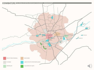
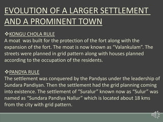
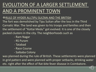
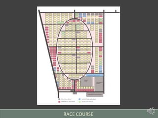
HUMAN SETTLEMENTS AND
PLANNING
COIMBATORE
THE CRADLE OF NOYYAL RIVER VALLEY
CIVILIZATION
CONTENTS
• Introduction-Image and Form of the City
• Geographical Factors
• Initial Settlement and Planning
• Rajasekara Peruvazhi-The trade route
• Planning of a bigger settlement
• Management of water resources
• Settlement planning in various rules
• Study on various Neighborhoods
• Inference-The future
Generally Radial planning refers to the method of organizing the areas in a
City by arranging them around a central point.
•The city was planned with a radial form with the core at the centre.
•The core comprised of the Fort, Koniamman temple, residential and commercial
complexes in it.
•The city has seen its growth and evolution of neighborhoods towards the
eastern,north-eastern and south-eastern sides mostly.
•The commercial hubs such as Ukkadam,Gandhipuram are located straight after
the core.
•Whereas the residential hubs such as Kottaimedu,Selvapuram,Ramnagar,
Ganapathy evolved right after those commercial hubs.
RADIAL FORM OF THE CITY
GEOGRAPHICAL FEATURES
The Western Ghats is located to the western part of the settlement and
is rich in flora and fauna. The Palghat Pass is present near Coimbatore
in the western Ghats. It bring about connectivity between the western
coast and eastern coast connecting Kochi and Arikamedu. The Palghat
Pass helps in maintaining the pleasant climate of Coimbatore. The
Noyyal River helped in agriculture in the settlement.
GEOGRAPHICAL FEATURES
INITIAL SETTLEMENT AND PLANNING
The settlement was named after a local chieftain “Kovan” and was
named as “Kovan Puthur” or “Kovan Pathi”. The settlement was a part
of the Perur Nadu, one of the princely state in the Kongunadu region.
The settlement was formed near the northern banks of River Noyyal.
The settlement had “Koniamma” as the guardian goddess of the
settlement. The settlement was formed as a cluster with the house
of the chieftain in the centre. The temple was located at the southern
end of the settlement near the banks of river Noyyal.
RAJASEKARA PERUVAZHI-THE TRADE ROUTE
The principal trade between Kochi and Arikamedu was important in
the growth of Coimbatore as a settlement. The trade route passed
through Thrissur, Palakad, Vellalore, Perur, Coimbatore, Dharapuram,
Karur and eventually reached Arikamedu. Many Roman coins are found
in the trade route. This had been catalyst for the small settlement to
evolve as an important town also brought an geographical importance
to the settlement.
PLANNING OF A BIGGER SETTLEMENT
Around 4th century AD, Cheran Perumal planned to clear the forest
and had a plan for building a larger settlement. A fort was built about
1.5 kms away from the northern bank of River Noyyal. The settlement
was planned in a cluster with less green cover. The Koniamman temple
was built inside the fort to act as the guardian goddess of the fort and
the settlement with houses of traders,farmers,artists etc..
MANAGEMENT OF WATER RESOURCES
The Noyyal River which was known as “Kanchi Maanadhi” is the most important
aspect of the settlement of Kovan Puthur. Noyyal River originates from the Vellingiri
hills in the Western Ghats and passes for about 200 kms to merge with Kaveri river
in a village called Noyyal near Karur. Karikala Chola planned the management of
water in the Noyyal River in the form of Check-dams,Lakes etc. The “Chithirai
Saavadi” check dam is the first check dam in the Noyyal river basin. Then the water
passes through Perur Lake and travels through the “Raja Vaikaal” and reaches Selva
Sinthamani Lake, Kurichi Lake, Ukkadam Lake and Valankulam Lake. Then the river
water serves the Singanallur Lake and Vellalore Lake. In case of excess water in the
river, it might pass through Puliakulam Lake and Ammankulam Lake. Then finally the
water passes through the Sulur Lake and then flows towards north-east to reach the
settlements of Mangalam, Tirupur etc.
MANAGEMENT OF WATER RESOURCES
NOYYAL RIVER
CHITHIRAI SAVADI
CHECK DAM
PERUR LAKE
SELVASINTHAMANI
LAKE
UKKADAM LAKE KURICHI LAKE
VALANKULAM
LAKE
SINGANALLUR
LAKE
PULIAKULAM
AMMANKULAM
MUTHANNAN
KULAM
VELLALORE
LAKE
SULUR
LAKE RASIPALAYAM
LAKE
PEEDAMPALLI
LAKE
RAVATHOOR
LAKE
Merges with Kaveri river
At Noyyal village
EVOLUTION OF A LARGER SETTLEMENT
AND A PROMINENT TOWN
KONGU CHOLA RULE
A moat was built for the protection of the fort along with the
expansion of the fort. The moat is now known as “Valankulam”. The
streets were planned in grid pattern along with houses planned
according to the occupation of the residents.
PANDYA RULE
The settlement was conquered by the Pandyas under the leadership of
Sundara Pandiyan. Then the settlement had the grid planning coming
into existence. The settlement of “Suralur” known now as “Sulur” was
named as “Sundara Pandiya Nallur” which is located about 18 kms
from the city with grid pattern.
EVOLUTION OF A LARGER SETTLEMENT
AND A PROMINENT TOWN
RULE OF VIJAYANAGARA EMPIRE
The settlement of Kovan Puthur had an excess in population with the
settling of people from the Vijayanagara Kingdom. Till now quite a
good number of Telugu population is still now present in the region.
Then new neighborhoods such as
- Perianaicken Palayam
-Telugu Palayam
- Pappanaicken Palayam
- Peelamedu got evolved.
EVOLUTION OF A LARGER SETTLEMENT
AND A PROMINENT TOWN
RULE OF MADURAI NAYAKS,SULTANATE AND MYSORE KINGDOM
The settlement came under the rule of Madurai Nayaks, Sultanate and
finally the Mysore Kingdom. In the rule of Mysore Kingdom, a general
was appointed to govern the Perur Nadu with “Kovan Puthur” as its
capital. Then the streets in the city got its final shape with the
construction of Palace for Mathey Raja, the governor of Mysore
Kingdom and the street in which the palace was located was named as
“Raja Street”. Then “Theppakulam” was built near the palace which
was near the temple which had the goddess worshipped by the ruler
and his troops.The grid planning was involved.
CORE CITY
EVOLUTION OF A LARGER SETTLEMENT
AND A PROMINENT TOWN
RULE OF HYDER ALI,TIPU SULTAN AND THE BRITISH
The fort was demolished by Tipu Sultan after the loss in the Third
Carnatic War. The land was given to his troops and families and then
the settlement of “Kottai Medu” got evolved. It is one of the closely
packed clusters in the city. The neighborhoods such as
- Ram Nagar
- RS Puram
- Tatabad
- Race Course
- Saibaba Colony
was planned during the rule of British. These settlements were planned
in grid pattern and were planned with proper setbacks, drinking water
etc. right after the effect of Rat-bite fever disease in Coimbatore.
DETAILED NOTE ON NEIGHBOURHOODS
SINGANALLUR
The settlement was planned by Karikala Chola after his mother “Singarammal” as
“Singanallur”. In the word “Singanallur” – ‘Nallur’ refers to the settlement dedicated to the
temples and were known as “Sadurvedi Mangalams” in the Kongunadu region.The settlement
was planned with Noyyal River to its South and the road to Tiruchirapalli to its north. The road
to Vellalore passes through the settlement and is front of the site which is ‘believed to have
the palace of the mentioned queen who moved here after the calamity in Uraiyur, the capital
of the Cholas. The settlement had Savadi in its centre with the Aravan temple to its south and
the houses to its East along with the Ulagalanda Perumal temple and Agraharam to its South
on the way to Noyyal River.
SINGANALLUR
DETAILED NOTE ON NEIGHBOURHOODS
RS PURAM
The rate-bite fever in the early years of the 20th century gave the idea of spacious settlements
to prevent the people from getting stuck in a closely living community. So a settlement was
planned between the Mettupalayam Road and Thadagam Road. It was planned in a grid
pattern with the Diwan Bahadur Road passing through its centre dividing the locality into
western and eastern parts. The settlement had the Siruvani water from the purification plant in
the Siruvani Dam to serve as drinking water foe people. The locality evolved into one of the
commercial and residential hub of the city.
RS PURAM
DETAILED NOTE ON NEIGHBOURHOODS
RACE COURSE
The British settled in Coimbatore during the colonial rule. Farmlands in between the Trichy
Road and Avinashi Road was bought and a British settlement was planned with an elliptical
shaped road was planned to host horse races and a few horizontal and vertical roads were
planned to have residences of the collector and other high officials with proper setbacks and
spacing between the buildings.
RACE COURSE
CHARACTERISTICS OF BRITISH PLANNING
GRID PLANNING
It is composed of straight streets crossing at right angles to create
Many regular city blocks. This form is typical of cities built after the
Industrial revolution because only then did cities place such importance
on economic activity. A city grid iron plan facilitates the movement of
people and product throughout the city.
RAM NAGAR SAIBABACOLONY TATABAD
GRID PLANNING
ADVANTAGES
• High accessibility.
• Minimum disruption of flow.
• Expansion flexibility.
• Excellent psychological orientation.
• Adaptability to level or moderately rolling terrain.
DISADVANTAGES
• Requires flow hierarchies.
• Limited in its adaptability to the terrain.
• Potentially monotonous.
PRESENTATION BY
PRASANTH.M
SOWJITH LAL.M.S
AATHI RAKESH.R
KEERTHANA.R
VINOTH VIDHYADARAN.A
GOKUL PRASATH.R

Coimbatore - Urban Settlement and Planning

  • 1.
  • 2.
    COIMBATORE THE CRADLE OFNOYYAL RIVER VALLEY CIVILIZATION
  • 3.
    CONTENTS • Introduction-Image andForm of the City • Geographical Factors • Initial Settlement and Planning • Rajasekara Peruvazhi-The trade route • Planning of a bigger settlement • Management of water resources • Settlement planning in various rules • Study on various Neighborhoods • Inference-The future
  • 6.
    Generally Radial planningrefers to the method of organizing the areas in a City by arranging them around a central point. •The city was planned with a radial form with the core at the centre. •The core comprised of the Fort, Koniamman temple, residential and commercial complexes in it. •The city has seen its growth and evolution of neighborhoods towards the eastern,north-eastern and south-eastern sides mostly. •The commercial hubs such as Ukkadam,Gandhipuram are located straight after the core. •Whereas the residential hubs such as Kottaimedu,Selvapuram,Ramnagar, Ganapathy evolved right after those commercial hubs. RADIAL FORM OF THE CITY
  • 7.
    GEOGRAPHICAL FEATURES The WesternGhats is located to the western part of the settlement and is rich in flora and fauna. The Palghat Pass is present near Coimbatore in the western Ghats. It bring about connectivity between the western coast and eastern coast connecting Kochi and Arikamedu. The Palghat Pass helps in maintaining the pleasant climate of Coimbatore. The Noyyal River helped in agriculture in the settlement.
  • 8.
  • 9.
    INITIAL SETTLEMENT ANDPLANNING The settlement was named after a local chieftain “Kovan” and was named as “Kovan Puthur” or “Kovan Pathi”. The settlement was a part of the Perur Nadu, one of the princely state in the Kongunadu region. The settlement was formed near the northern banks of River Noyyal. The settlement had “Koniamma” as the guardian goddess of the settlement. The settlement was formed as a cluster with the house of the chieftain in the centre. The temple was located at the southern end of the settlement near the banks of river Noyyal.
  • 10.
    RAJASEKARA PERUVAZHI-THE TRADEROUTE The principal trade between Kochi and Arikamedu was important in the growth of Coimbatore as a settlement. The trade route passed through Thrissur, Palakad, Vellalore, Perur, Coimbatore, Dharapuram, Karur and eventually reached Arikamedu. Many Roman coins are found in the trade route. This had been catalyst for the small settlement to evolve as an important town also brought an geographical importance to the settlement.
  • 11.
    PLANNING OF ABIGGER SETTLEMENT Around 4th century AD, Cheran Perumal planned to clear the forest and had a plan for building a larger settlement. A fort was built about 1.5 kms away from the northern bank of River Noyyal. The settlement was planned in a cluster with less green cover. The Koniamman temple was built inside the fort to act as the guardian goddess of the fort and the settlement with houses of traders,farmers,artists etc..
  • 12.
    MANAGEMENT OF WATERRESOURCES The Noyyal River which was known as “Kanchi Maanadhi” is the most important aspect of the settlement of Kovan Puthur. Noyyal River originates from the Vellingiri hills in the Western Ghats and passes for about 200 kms to merge with Kaveri river in a village called Noyyal near Karur. Karikala Chola planned the management of water in the Noyyal River in the form of Check-dams,Lakes etc. The “Chithirai Saavadi” check dam is the first check dam in the Noyyal river basin. Then the water passes through Perur Lake and travels through the “Raja Vaikaal” and reaches Selva Sinthamani Lake, Kurichi Lake, Ukkadam Lake and Valankulam Lake. Then the river water serves the Singanallur Lake and Vellalore Lake. In case of excess water in the river, it might pass through Puliakulam Lake and Ammankulam Lake. Then finally the water passes through the Sulur Lake and then flows towards north-east to reach the settlements of Mangalam, Tirupur etc.
  • 13.
    MANAGEMENT OF WATERRESOURCES NOYYAL RIVER CHITHIRAI SAVADI CHECK DAM PERUR LAKE SELVASINTHAMANI LAKE UKKADAM LAKE KURICHI LAKE VALANKULAM LAKE SINGANALLUR LAKE PULIAKULAM AMMANKULAM MUTHANNAN KULAM VELLALORE LAKE SULUR LAKE RASIPALAYAM LAKE PEEDAMPALLI LAKE RAVATHOOR LAKE Merges with Kaveri river At Noyyal village
  • 14.
    EVOLUTION OF ALARGER SETTLEMENT AND A PROMINENT TOWN KONGU CHOLA RULE A moat was built for the protection of the fort along with the expansion of the fort. The moat is now known as “Valankulam”. The streets were planned in grid pattern along with houses planned according to the occupation of the residents. PANDYA RULE The settlement was conquered by the Pandyas under the leadership of Sundara Pandiyan. Then the settlement had the grid planning coming into existence. The settlement of “Suralur” known now as “Sulur” was named as “Sundara Pandiya Nallur” which is located about 18 kms from the city with grid pattern.
  • 15.
    EVOLUTION OF ALARGER SETTLEMENT AND A PROMINENT TOWN RULE OF VIJAYANAGARA EMPIRE The settlement of Kovan Puthur had an excess in population with the settling of people from the Vijayanagara Kingdom. Till now quite a good number of Telugu population is still now present in the region. Then new neighborhoods such as - Perianaicken Palayam -Telugu Palayam - Pappanaicken Palayam - Peelamedu got evolved.
  • 16.
    EVOLUTION OF ALARGER SETTLEMENT AND A PROMINENT TOWN RULE OF MADURAI NAYAKS,SULTANATE AND MYSORE KINGDOM The settlement came under the rule of Madurai Nayaks, Sultanate and finally the Mysore Kingdom. In the rule of Mysore Kingdom, a general was appointed to govern the Perur Nadu with “Kovan Puthur” as its capital. Then the streets in the city got its final shape with the construction of Palace for Mathey Raja, the governor of Mysore Kingdom and the street in which the palace was located was named as “Raja Street”. Then “Theppakulam” was built near the palace which was near the temple which had the goddess worshipped by the ruler and his troops.The grid planning was involved.
  • 17.
  • 18.
    EVOLUTION OF ALARGER SETTLEMENT AND A PROMINENT TOWN RULE OF HYDER ALI,TIPU SULTAN AND THE BRITISH The fort was demolished by Tipu Sultan after the loss in the Third Carnatic War. The land was given to his troops and families and then the settlement of “Kottai Medu” got evolved. It is one of the closely packed clusters in the city. The neighborhoods such as - Ram Nagar - RS Puram - Tatabad - Race Course - Saibaba Colony was planned during the rule of British. These settlements were planned in grid pattern and were planned with proper setbacks, drinking water etc. right after the effect of Rat-bite fever disease in Coimbatore.
  • 19.
    DETAILED NOTE ONNEIGHBOURHOODS SINGANALLUR The settlement was planned by Karikala Chola after his mother “Singarammal” as “Singanallur”. In the word “Singanallur” – ‘Nallur’ refers to the settlement dedicated to the temples and were known as “Sadurvedi Mangalams” in the Kongunadu region.The settlement was planned with Noyyal River to its South and the road to Tiruchirapalli to its north. The road to Vellalore passes through the settlement and is front of the site which is ‘believed to have the palace of the mentioned queen who moved here after the calamity in Uraiyur, the capital of the Cholas. The settlement had Savadi in its centre with the Aravan temple to its south and the houses to its East along with the Ulagalanda Perumal temple and Agraharam to its South on the way to Noyyal River.
  • 20.
  • 21.
    DETAILED NOTE ONNEIGHBOURHOODS RS PURAM The rate-bite fever in the early years of the 20th century gave the idea of spacious settlements to prevent the people from getting stuck in a closely living community. So a settlement was planned between the Mettupalayam Road and Thadagam Road. It was planned in a grid pattern with the Diwan Bahadur Road passing through its centre dividing the locality into western and eastern parts. The settlement had the Siruvani water from the purification plant in the Siruvani Dam to serve as drinking water foe people. The locality evolved into one of the commercial and residential hub of the city.
  • 22.
  • 23.
    DETAILED NOTE ONNEIGHBOURHOODS RACE COURSE The British settled in Coimbatore during the colonial rule. Farmlands in between the Trichy Road and Avinashi Road was bought and a British settlement was planned with an elliptical shaped road was planned to host horse races and a few horizontal and vertical roads were planned to have residences of the collector and other high officials with proper setbacks and spacing between the buildings.
  • 24.
  • 25.
    CHARACTERISTICS OF BRITISHPLANNING GRID PLANNING It is composed of straight streets crossing at right angles to create Many regular city blocks. This form is typical of cities built after the Industrial revolution because only then did cities place such importance on economic activity. A city grid iron plan facilitates the movement of people and product throughout the city. RAM NAGAR SAIBABACOLONY TATABAD
  • 26.
    GRID PLANNING ADVANTAGES • Highaccessibility. • Minimum disruption of flow. • Expansion flexibility. • Excellent psychological orientation. • Adaptability to level or moderately rolling terrain. DISADVANTAGES • Requires flow hierarchies. • Limited in its adaptability to the terrain. • Potentially monotonous.
  • 28.
    PRESENTATION BY PRASANTH.M SOWJITH LAL.M.S AATHIRAKESH.R KEERTHANA.R VINOTH VIDHYADARAN.A GOKUL PRASATH.R