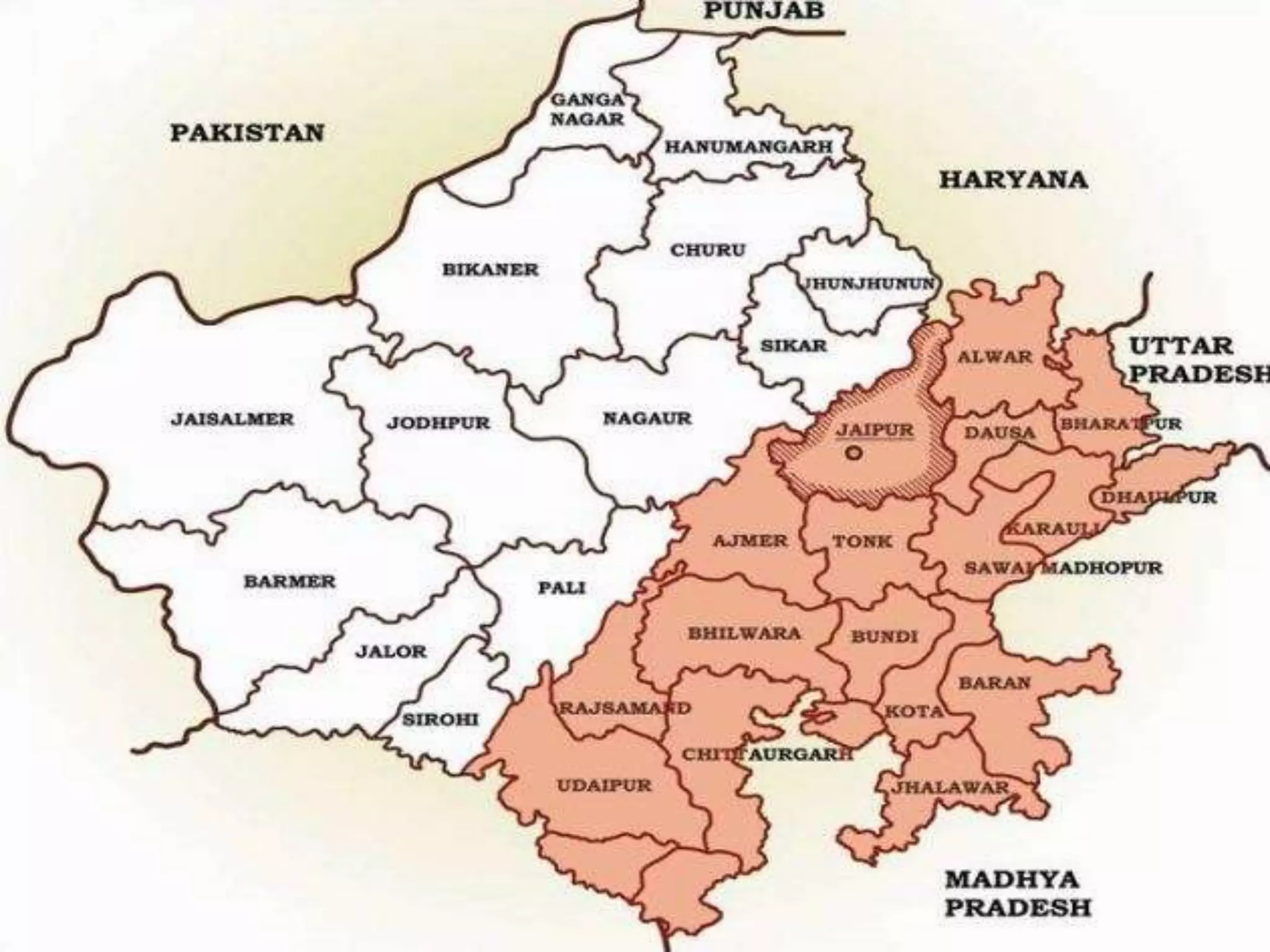
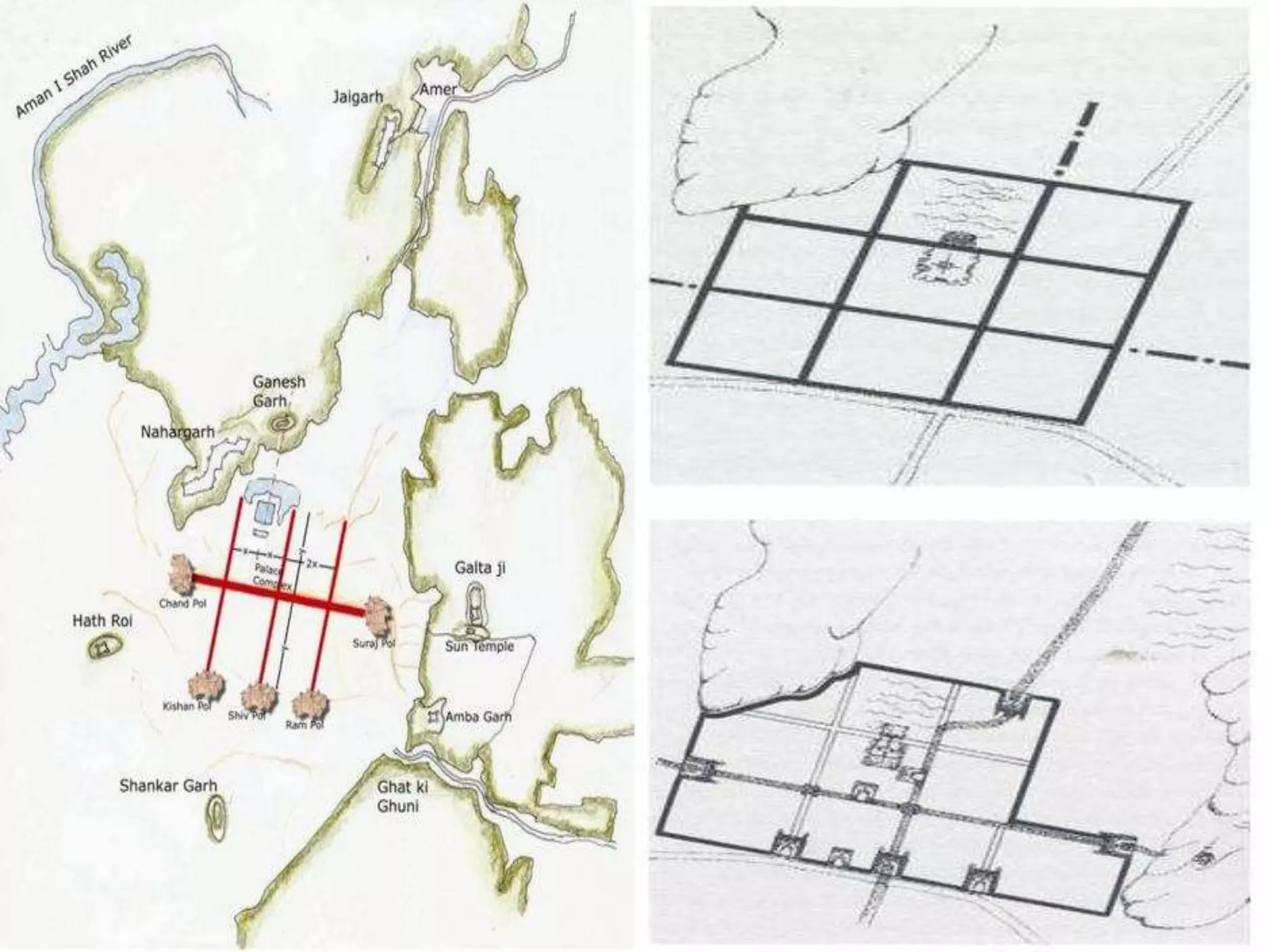
Jaipur was founded in 1727 by Maharaja Sawai Jai Singh II as the new capital of Amber. He followed principles of Hindu urban planning to design the city, dividing it into nine blocks with wide streets and central squares. The city was planned with military defense and expansion in mind. Over time, new structures like Hawa Mahal were added and the city grew beyond its original walls. Today, Jaipur is known for its pink buildings and is a well-planned city with distinct architecture, markets, temples, and palaces that showcase Rajasthani culture and heritage.
JAIPUR CITY URBAN DESIGN, ANALYSIS.
REPORT BASED ON THE PAPER:-
Space Formation of Jaipur City, Rajastan, India An
Analysis on City Maps (1925-28) made by Survey of
India
Shuji Funo, Naohiko Yamamoto & Mohan Pant
JAIPUR CITY URBAN DESIGN, ANALYSIS.
REPORT BASED ON THE PAPER:-
Space Formation of Jaipur City, Rajastan, India An
Analysis on City Maps (1925-28) made by Survey of
India
Shuji Funo, Naohiko Yamamoto & Mohan Pant
INTRODUCTION
COORDINATES - 23.22 ON 72.680 E ELEVATION - 265 feet (81 m)*
LOCATED 23 KM NORTH OF AHEMDABAD (FIN CAP. OF GUJARAT)
PLANNED IN 1960S BY, PRAKASH M APTE & H. K. MEWADA,
AFTER PARTITION OF BOMBAY * STATE : AHEMDABAD WAS MADE AS THE CAPTAL OFGUJARAT
AREA TOTAL 177KM2 ELEVATION : 8IM ( 266 FT)
POPULATION (2011)
TOTAL: 206,167 DENSITY : 1,200/KM2
CLIMATE*
TROPICAL WET AND DRY CLIMATE•
SUMMER MAXIMUM - 36 to 42 °C MINIMUM - 19 to 27 C
WINTER MAXIMUM - 29 C MINIMUM - 14°C
MONSOON: THE AVERAGE ANNUAL RAINFALL IS AROUND 803.4 MM
LANGUAGES
GUJARATI, HINDI, AND ENGLISH• 54% GREEN COVER ON ITS LAND AREA
• THE CITY SITS ON THE BANKS OF THE SABARMATI RIVER, IN NORTH-CENTRALEAST GUJARAT
HISTORY
IN 1960, THE INDIAN STATE OF BOMBAY WAS SPLIT INTO TWO STATES, MAHARASHTRA AND GUJARAT LEAVING GUJARAT WITHOUT A CAPITAL CITY.
AT THE TIME AHMEDABAD WAS SELECTED TO BE THE FIRST CAPITAL OF THE NEWLY CREATED STATE.
• IT WAS LATER PROPOSED THAT A NEW CAPITAL CITY BE CONSTRUCTED FOR THE STATE.
• GANDHINAGAR GOT AN IDENTITY OF ITS OWN WHEN THE STATE OF MUMBAI WAS DIVIDED INTO TWO SEPARATE STATES OF GUJARAT AND MAHARASHTRA.
• IN THE BEGINNING, AHMEDABAD - A COMMERCIAL HUB OF GUJARAT WAS CHOSEN AS THE STATE CAPITAL AND IT WAS PROPOSED THAT A NEW CAPITAL SHOULD BE CONSTRUCTED ALONG THE LINE OF OTHER NEW STATE CAPITALS, PARTICULARLY CHANDIGARH
• THEREFORE TWO WELL-KNOWN INDIAN ARCHITECTS, H.K. MEWADA AND PRAKASH M. APTE (WHO WORKED AS BEGINNER FOR THE CHANDIGARH CITY) DESIGNED THE NEW STATE CAPITAL*
NAMED AFTER MAHATMA GANDHI THE FOUNDATION STONE OF THIS CITY WAS LAID ON 1965 AND IN 1971 THE CAPITAL WAS SHIFTED FROM AHMEDABAD TO GANDHINAGAR
PLANNING
• PLANNED AND IMPLEMENTED BETWEEN 1965-1970
• DETERMINATION TO MAKE GANDHINAGAR A PURELY INDIAN ENTERPRISE, PARTLY BECAUSE GUJARAT WAS THE BIRTHPLACE OF GANDHI.
• TO ESTABLISH AND MAINTAIN A SEPARATE IDENTITY FOR THE NEW CITY THE SURROUNDING AREA OF ABOUT 39 VILLAGES WAS BROUGHT UNDER A PERIPHERY CONTROL ACT (AS IN CHANDIGARH)
• THE AREA LATER CONSTITUTED A SEPARATE ADMINISTRATIVE DISTRICT OF GANDHINAGAR.
• THE CITY WAS PLANNED FOR A POPULATION OF 150,000 BUT CAN ACCOMMODATE DOUBLE THAT POPULATION WITH INCREASE IN THE FLOOR SPACE RATIO FROM 1 TO 2 IN THE AREAS RESERVED FOR PRIVATE DEVELOPMENT.
• THE RIVER BEING THE BORDER ON THE EAST, AND THE INDUSTRIAL AREA TO THE NORTH, THE MOST LOGICAL FUTURE PHYSICAL EXPANSION OF THE CITY WAS ENVISAGED TOWARDS THE NORTH-WEST
The case study is about the india's most well planned city that is Jaipur, Rajasthan. what is the urban sprawl in that city and how it grows that will expained in that.
architectural case study
Asian games village designed by ar. raj rewal
B.Arch 4th-year sem 7
detailed zoning
analysis and survey
concept execution
referral links
https://www.scribd.com/document/415212492/Asian-Games-Village-Final
https://portfolio.cept.ac.in/fp/from-utopias-to-heterotopias-migrant-housing-values-of-time-density-culture-and-energy-ur2005-monsoon-2019/building-blocks-of-migrant-housing-monsoon-2019-ug180076
https://www.slideshare.net/WaseemNoor3/raj-rewal-asian-games-village
https://www.archdaily.com/903782/asian-games-village-residence-iii-viueller-architects
https://rajrewal.in/portfolio/asian-games-village-1980-1982/
https://qdoc.tips/asiad-villagegrp-6-pdf-free.html
https://s3.us-east-1.amazonaws.com/media.archnet.org/system/publications/contents/2850/original/DPT0402.pdf?1384768113
https://prezi.com/zj7br3xisvu8/asiad-village/
Urban conservation techniques and strategies mainly followed in the INDIA.This is done for my friends in B.ARCH(VIIth semester) JNAFAU & JNTUK.
University.
Use of Architectural Elements in Evolution of Traditional StyleSHUBHAM SHARMA
The research paper prepared by me gives a brief idea about traditional and architectural components of rajasthan. This features can be used as a basic components in modern and contemporary architecture to achieve extents of sustainability.
The evolution of the settlement followed by the expansion in various rules such as Cheras,Cholas,Pandyas,Mysore Kingdom,Madurai Nayaks and the British and inference
Urban Renewal and conservation of Kancheepuram, Tamil Nadu
Heritage background, places of importance, cultural background, land use and activities with respect to heritage conservation
DevOps and Testing slides at DASA ConnectKari Kakkonen
My and Rik Marselis slides at 30.5.2024 DASA Connect conference. We discuss about what is testing, then what is agile testing and finally what is Testing in DevOps. Finally we had lovely workshop with the participants trying to find out different ways to think about quality and testing in different parts of the DevOps infinity loop.
Smart TV Buyer Insights Survey 2024 by 91mobiles.pdf91mobiles
91mobiles recently conducted a Smart TV Buyer Insights Survey in which we asked over 3,000 respondents about the TV they own, aspects they look at on a new TV, and their TV buying preferences.
Neuro-symbolic is not enough, we need neuro-*semantic*Frank van Harmelen
Neuro-symbolic (NeSy) AI is on the rise. However, simply machine learning on just any symbolic structure is not sufficient to really harvest the gains of NeSy. These will only be gained when the symbolic structures have an actual semantics. I give an operational definition of semantics as “predictable inference”.
All of this illustrated with link prediction over knowledge graphs, but the argument is general.
Connector Corner: Automate dynamic content and events by pushing a buttonDianaGray10
Here is something new! In our next Connector Corner webinar, we will demonstrate how you can use a single workflow to:
Create a campaign using Mailchimp with merge tags/fields
Send an interactive Slack channel message (using buttons)
Have the message received by managers and peers along with a test email for review
But there’s more:
In a second workflow supporting the same use case, you’ll see:
Your campaign sent to target colleagues for approval
If the “Approve” button is clicked, a Jira/Zendesk ticket is created for the marketing design team
But—if the “Reject” button is pushed, colleagues will be alerted via Slack message
Join us to learn more about this new, human-in-the-loop capability, brought to you by Integration Service connectors.
And...
Speakers:
Akshay Agnihotri, Product Manager
Charlie Greenberg, Host
UiPath Test Automation using UiPath Test Suite series, part 3DianaGray10
Welcome to UiPath Test Automation using UiPath Test Suite series part 3. In this session, we will cover desktop automation along with UI automation.
Topics covered:
UI automation Introduction,
UI automation Sample
Desktop automation flow
Pradeep Chinnala, Senior Consultant Automation Developer @WonderBotz and UiPath MVP
Deepak Rai, Automation Practice Lead, Boundaryless Group and UiPath MVP
Software Delivery At the Speed of AI: Inflectra Invests In AI-Powered QualityInflectra
In this insightful webinar, Inflectra explores how artificial intelligence (AI) is transforming software development and testing. Discover how AI-powered tools are revolutionizing every stage of the software development lifecycle (SDLC), from design and prototyping to testing, deployment, and monitoring.
Learn about:
• The Future of Testing: How AI is shifting testing towards verification, analysis, and higher-level skills, while reducing repetitive tasks.
• Test Automation: How AI-powered test case generation, optimization, and self-healing tests are making testing more efficient and effective.
• Visual Testing: Explore the emerging capabilities of AI in visual testing and how it's set to revolutionize UI verification.
• Inflectra's AI Solutions: See demonstrations of Inflectra's cutting-edge AI tools like the ChatGPT plugin and Azure Open AI platform, designed to streamline your testing process.
Whether you're a developer, tester, or QA professional, this webinar will give you valuable insights into how AI is shaping the future of software delivery.
Elevating Tactical DDD Patterns Through Object CalisthenicsDorra BARTAGUIZ
After immersing yourself in the blue book and its red counterpart, attending DDD-focused conferences, and applying tactical patterns, you're left with a crucial question: How do I ensure my design is effective? Tactical patterns within Domain-Driven Design (DDD) serve as guiding principles for creating clear and manageable domain models. However, achieving success with these patterns requires additional guidance. Interestingly, we've observed that a set of constraints initially designed for training purposes remarkably aligns with effective pattern implementation, offering a more ‘mechanical’ approach. Let's explore together how Object Calisthenics can elevate the design of your tactical DDD patterns, offering concrete help for those venturing into DDD for the first time!
Encryption in Microsoft 365 - ExpertsLive Netherlands 2024Albert Hoitingh
In this session I delve into the encryption technology used in Microsoft 365 and Microsoft Purview. Including the concepts of Customer Key and Double Key Encryption.
Key Trends Shaping the Future of Infrastructure.pdfCheryl Hung
Keynote at DIGIT West Expo, Glasgow on 29 May 2024.
Cheryl Hung, ochery.com
Sr Director, Infrastructure Ecosystem, Arm.
The key trends across hardware, cloud and open-source; exploring how these areas are likely to mature and develop over the short and long-term, and then considering how organisations can position themselves to adapt and thrive.
Epistemic Interaction - tuning interfaces to provide information for AI supportAlan Dix
Paper presented at SYNERGY workshop at AVI 2024, Genoa, Italy. 3rd June 2024
https://alandix.com/academic/papers/synergy2024-epistemic/
As machine learning integrates deeper into human-computer interactions, the concept of epistemic interaction emerges, aiming to refine these interactions to enhance system adaptability. This approach encourages minor, intentional adjustments in user behaviour to enrich the data available for system learning. This paper introduces epistemic interaction within the context of human-system communication, illustrating how deliberate interaction design can improve system understanding and adaptation. Through concrete examples, we demonstrate the potential of epistemic interaction to significantly advance human-computer interaction by leveraging intuitive human communication strategies to inform system design and functionality, offering a novel pathway for enriching user-system engagements.
State of ICS and IoT Cyber Threat Landscape Report 2024 previewPrayukth K V
The IoT and OT threat landscape report has been prepared by the Threat Research Team at Sectrio using data from Sectrio, cyber threat intelligence farming facilities spread across over 85 cities around the world. In addition, Sectrio also runs AI-based advanced threat and payload engagement facilities that serve as sinks to attract and engage sophisticated threat actors, and newer malware including new variants and latent threats that are at an earlier stage of development.
The latest edition of the OT/ICS and IoT security Threat Landscape Report 2024 also covers:
State of global ICS asset and network exposure
Sectoral targets and attacks as well as the cost of ransom
Global APT activity, AI usage, actor and tactic profiles, and implications
Rise in volumes of AI-powered cyberattacks
Major cyber events in 2024
Malware and malicious payload trends
Cyberattack types and targets
Vulnerability exploit attempts on CVEs
Attacks on counties – USA
Expansion of bot farms – how, where, and why
In-depth analysis of the cyber threat landscape across North America, South America, Europe, APAC, and the Middle East
Why are attacks on smart factories rising?
Cyber risk predictions
Axis of attacks – Europe
Systemic attacks in the Middle East
Download the full report from here:
https://sectrio.com/resources/ot-threat-landscape-reports/sectrio-releases-ot-ics-and-iot-security-threat-landscape-report-2024/
2. Jaipur lies at a distance of about 200 miles
from Delhi, 150 miles from Agra and 84 miles
from Ajmer. Capital city of Rajasthan is located
amidst the Aravali hill ranges at an altitude of
about 430 m above sea level.
Latitude – 26 55’ N
Longitude – 75 50’ E
The eastern Rajasthan, lying to the east and
south east of the Aravalli divide includes the
modern administrative districts of – Udaipur,
Chittorgarh, Rajsamand, Banswara, Dungarpur,
Kota, Bundi, Baran, Jhalawar, Bhilwara, Ajmer,
Jaipur, Tonk, Dausa, Dholpur, Karauli,
Bharatpur and Alwar.
The current district of Jaipur lies in Eastern
Rajasthan, in the Banas River basin and forms a
part of Eastern Plain of Rajasthan. The region
is drained by a number of seasonal rivers of
which Banganga, Dhundh and Bandi are
prominent.
3. In Aryan epics, Dhoondhar region (called
Matsya Desh/ Mina Wati) was the shortest
trade route between north India and rich port
cities of Gujarat and Malabar. The region was
held by Badgujars, Rajputs and Minas till the
11th century.
From the 11th century onwards, however, the
Dhoondhar region was increasingly under the
power of Kachchwaha dynasty of Rajputs.
The three main capitals of the Dhoondhar
Region under the Kachchwahas –
Dausa Amber Jaipur.
Sawai Jai Singh II (1700 – 1743) who outlived
five Mughal emperors and tried to prop up the
Mughal Empire from 1707 – (Aurangzeb’s
death) to sack of Delhi by Nadir Shah (1739)
established the city of Jaipur and strengthened
the boundaries of Dhoondhar.
5. Modern Jaipur was founded in 1727 by
Maharaja Sawai Jai Singh II of Amber who
ruled from 1699–1744.
Initially, his capital was Amber, which lies
11 km from Jaipur.
6. The generic plan of a medieval
Rajasthani hill town- as in Dausa
and Amber (TOP)
A – Religious centre or temple
B – Political centre or for
C – Gates and walls
D – Havelis and houses
The site selected for establishing the new
capital of Jaipur was a valley
located south of Amber and the plains
beyond, a terrain that was the
bed of a dried lake. There used to be
dense forest cover to the north
and the east of the city.
To facilitate water supply to the new city,
the Darbhavati river in the
north was dammed to create the Jai
Sagar and Man Sagar (that later
housed the Jal Mahal) lakes.
The east-west axis of the town was
divided by three perpendicular roads into
eight portions with the central
ones of equal size and the outer ones as
per the remaining dimensions till the
Chand Pol in the west and Suraj Pol in
the east.
7. Reasons for Maharaja Sawai
Jai Singh to change his capital
from Amber to Jaipur :
8. Military Reasons
Defence was an important consideration. A site
at the South of Amber ensured greater
distance from Delhi and also prevented the
expansion of the city in that direction.
It was clear that the out skirting hill ranges
(Nahargarh hills) shaped as a horseshoe would
allow the new city to expand only in the South.
So this flat site with a basin like shape was
chosen. It was an open plain bounded on the
north-west and east by hills.
Geographical Reasons
The rocky terrain of Amber restricted
expansion.
Jaipur had the potentialities of
developing into a city with adequate
drinking water due to the presence
of a perennial stream nearby and
good drainage system.
Its rugged hills also ensured a
constant supply of building material,
which might be required in the times
to come
10. PRASTARA PLAN: It is a model of town
planning- the first planned city in India. It is
based on Hindu systems of town planning and
followed the principles prescribed in the
Shilpa-shastra, an ancient Indian treatise on
architecture .according to this shastra the site
should be divided into grids or mandalas
rangung from 2x 2 to 10 x 10.
Planned according to the Prastara type of
layout, which gives prominence to the cardinal
directions.
Thus the plan of jaipur gridlines being the city’s
main streets.
The central axis of the town was laid from East
to West between the gates of the Sun(Suraj
pol) and the moon(Chandpol)
This was crossed by two roads at right angles
dividing the town into nine almost square,
almost equally sized blocks, which were
further sub divided by lanes and alleys all at
right angles.
The mandala could not be complete in the NW
due to the presence of the hills.
So this North-West ward was transferred to the
South-East corner of the city, making the shape
of the plan as a whole asymmetrical rather
than square.
The city’s division into nine wards was also in
conformity with the Hindu caste system, which
necessitated the segregation of people
belonging to different communities and ranks.
Even the lanes were named after the
occupations of inhabitants such as Maniharon
ka Rasta, Thatheron ka Rasta & many others.
Following the directions of the Hindu Shilpa
shastra, width of the main streets & other
lanes were fixed. Thus the main streets of the
city were 111ft. wide, secondary streets 55 ft.
wide & the smaller ones 27ft. wide.
11. South of the main road were four almost equal
rectangles. The rectangle opposite the palace
has been broken up into two equal and smaller
rectangles by the Chaura Rasta.Thus altogether
there are now five rectangles on the south of
the main road called Chowkris.
On the North of the main road from West to
East are the Purani Basti, the Palace and
Ramchandraji.
The principal bazaar leads from the western
gate in the city wall, The Chandpole, passing in
front of the Tripolia Gate, to the eastern city
gate, the Surajpole.
12. Later in the 18th and 19th centuries, there
were additions in the built fabric of the city
and the palace such as the Hawa Mahal and a
number of temples added by Sawai Pratap
Singh under whom the Jaipur architectural
vocabulary reached its peak in terms of
stylization.
In the 19th century, with the accession of
Sawai Ram Singh II, the city extended beyond
the old city walls, adapted newer modes of
transport such as the railways with a railway
station located on the western outskirts,
started using gaslights on the streets and
adopted modernized drainage and piped water
supply system.
The 20th century observed further
modernization and urban
renovations within the walled city, including
the restoration work of
the city walls and gates and, converting the
inner temporary houses
in the sectors into more permanent structures
14. WHY PINK?
Using pink to cut down glare
Jai Singh II's apparent devotion to Lord Shiva
(whose favorite color is reputedly terra cotta)
Pink is the traditional color of hospitality, and
the city was freshly painted and paved with
pink gravel to warmly welcome Edward VII for
his visit here in 1876.
15. ROAD NETWORK
Jaipur’s road network follows a definite hierarchy. The major east-west and north-south road ,form the sector boundaries
and are called Rajmarg as they lead to the city gates. These measure 33m. wide.
Next there is a network of 16.5m wide which runs north-south in each sector linking the internal areas of the sectors to the
major activity spine.
16. PUBLIC SPACES
CHAUPAR – It’s a square that occurs at the intersection of east west roads with three north
south roads. Each chaupar is around 100m x 100m. Were used for public gathering on festive
occasions. The distance between two chaupars is about 700m which is ideal for pedestrian
movement. It has controlled façade treatment enveloping it.
17. BAZAARS - Originally only four bazaars were
planned for the city. These were later named
as Johri bazaar, Sireh Deori Bazaar, Kishan pole
Bazaar & Gangori Bazaar
18. On the main streets strict control was exercised on the
street façade, along which were located shops and arcades-
one storey high, but beyond the frontage the buildings could
be of any height or any shape, some built with flat roofs &
others with traditional chattris.
Commercial
Footpath
Road Temple
Section through Ram Ganj Bazaar
Original markets in the city include Kishanpole
bazaar, Gangauri bazaar, Johari bazaar, Sireh Deorhi
bazaar, along the main north-south and east-west
axes that intersect at Chhoti and Badi Chaupars.
Bazaar streets have temples
above shops with wide
staircase starting from
pavement to the temple level.
Space above shops at first
floor level originally
functioned as galleries for
watching royal processions,
religious festivals and public
celebrations
19. TYPOLOGY OF FACADES
Façades of Jaipur and surroundings typically
have gokhdas (sitting spaces) on either side of
the entrance.
The openings are often characterized by
the use of cusped, trefoil or pointed arches
with rectangular or chhatri (vaulted dome)
type framing, flanked with lotus columns.
Stylistically, the bangaldar (curvilinear) roof
became prevalent in stone chhatris and
chhajjas (sunshades) and was later used in
other areas of
Rajasthan too
The bangaldar chhatri with
the sunshade following the
profile forms the focus of
the Chandra Mahal façade,
in the City Palace complex
Goyal Bhawan
20. TYPOLOGY OF TEMPLES
Each mohalla (cluster of houses) has its own temple presided over by the deity most appropriate for their prosperity and
protection. A relationship between temples and wells (both constituting ritual spaces) can be observed inside the
chowkries in the layout of the sectors.
21. TYPOLOGY OF HAVELIS
The havelis ofJaipur range from a single courtyard house form to an assemblage of multiple
courts, depending on the status of the owner and number of family members.
Majority of the havelis have one or two courtyards.
22. TYPOLOGY OF WATER BODIES
The surface water bodies – Talkatora, Jai Sagar,
Man Sagar (Jal Mahal Lake) and the Ramgarh
Lake were important features in the city plan. The
artificial lakes were created in response to the
natural topography
A unique water system of underground
canals was specially devised for the water
supply in the city and the square central tanks
were located in the Badi Chaupar and Chhoti
Chaupar.
23. VISION FOR PLANNED GROWTH
This section simulates the original form, studies transformations in built form over time and
demonstrates possibilities of enhancing the built heritage through planned intervention and
architectural guidance