New delhi lutyen's delhi
•Download as PPTX, PDF•
18 likes•9,118 views

1. Lutyens designed New Delhi with wide roads and grand buildings laid out along symmetrical axes and boulevards. At the center was Rashtrapati Bhawan atop Raisina Hill, connected to India Gate via Rajpath. 2. Significant buildings like the Secretariat and Parliament House were placed strategically along the central axis. Connaught Place was designed as the commercial hub. 3. While the new imperial capital housed the elite, the common people lived in growing slums with inadequate housing and infrastructure due to large migration to the city.

Recommended
More Related Content
What's hot
What's hot (20)
Similar to New delhi lutyen's delhi
Similar to New delhi lutyen's delhi (20)
Recently uploaded
Recently uploaded (20)
New delhi lutyen's delhi
- 1. LUTYEN’S DELHI -in terms of urban design Submitted by- AARTI RANI 1405005 sem-07
- 2. CONTENTS • New Delhi- Introduction • Topography • Map of Delhi • New Delhi as an Imperial Capital • Lutyen’s Delhi – Design – Initial Layout – The Central Axis – Placement of significant structures – Ariel view of Delhi – Features – Princely States – Land Use – Old Delhi vs. New Delhi – Significant Landmarks • Rashtrapati Bhawan • The Secretariat • Parliament House • India Gate • Jantar Mantar • Cannaught Place • Urban Nodes • Lutyen’s Bunglow Zone • Major Road Networks in the City • Airways • Common people in an Imperial Capital • Housing • Slums • Economy • Problems
- 3. NEW DELHI • Delhi is the largest metropolis of India and eighth largest of the World. • New Delhi is the capital and seat of government of India. It is also a municipality and district in Delhi. • Area- 1483 sq km. CLIMATE • Wind directions vary with season. • In the summers, the predominant wind directions are from the west in the morning and either west or northwest in the evening. • In the monsoons, the predominant wind directions are from the southeast or west in the morning and from east (in July and August) or north-west (in September) in the evenings. • Delhi has a semi arid climate, with hot summers, average rainfall and moderate winters. • Mean monthly temperatures range from 14.3° C in January to 34.5° C in June. • However, the extreme temperatures go upto 40-45° C in summers and 4- 5° C in winters. • The annual precipitation is about 711 mm.
- 4. -Delhi is located on the western fringes of the Gangetic Plains. -The Ridge, which reaches the height of 1043 ft above sea level, and is the highest point in Delhi. TOPOGRAPHY -The Yamuna is the main source of drinking water for the citizens of Delhi. -The main features of Delhi are the Aravali hill ranges and the Yamuna river. The Aravali hill ranges are covered with forest called the Ridges. -There is a forest cover of nearly 11.5% of the total area in Delhi. Delhi’s mineral sources are primarily sand and stone which are used for construction activities.
- 6. NEW DELHI AN IMPERIAL CAPITAL “He who rules Delhi, rules India.” • HISTORICAL BACKGROUND- – SEVEN CITIES- Indraprastha, Lal Kot, Qila Rai Pithora, Tughlaqabad, Jahanpanah, Firozabad, shergarh. – OLD DELHI, walled city was founded as Shahjahanabad by Mughal Emperor Shahjahan. • Major change and expansion of Urban Delhi started in the second decade of Twentieth Century when Britishers planned New Delhi, the Capital of India.
- 7. • The foundation stone of the city was laid by George V, Emperor of India during the Delhi Durbar of 1911. • NEW DELHI designed by Sir Edward Lutyens and Herbert Baker, redefined the architecture and urbanism of Delhi in the process of addressing contemporary imperatives.
- 9. •Lutyens had initially designed Delhi with all the streets crossing at right angles, much like in New York. •However, Lord Hardinge told him of the dust storms that sweep the landscape in these parts, insisting on roundabouts, hedges and trees to break their force, giving him the plans of Rome, Paris and Washington to study and apply to Delhi. •Lutyens plan for Delhi is purely geometrical in form. The initial design of New Delhi
- 10. Intentions of the Layout: Lutyens’ Delhi was planned on the most spacious garden city lines with the great avenues decorated with classical buildings with lush landscape. Image 1 Image 2
- 11. THE MAP PREPARED BY LUTYENS, Existing city- black and imperial Delhi- red
- 12. The central axis It connected the important government buildings, such as- Rashtrapati Bhawan, The Secretariat along its side, Sansad Bhawan, War memorial Arch, India Gate. The commercial hub, Connaught place is also connected to this axis perpendicularly.
- 14. Placement of significant structures: • New Delhi is structured around two central promenades called the Rajpath(Kingsway) and the Jan path. • At the heart of the city is the magnificent Rashtrapati Bhawan (formerly known as Viceroy's House) which sits atop Raisina Hill. • The Secretariat, which houses various ministries of the Government of India, flanks out of the Rashtrapati Bhawan. • The Parliament House, designed by Herbert Baker, is located at the Sansad Marg, which runs parallel to the Rajpath. • Twelve separate roads lead out of the outer ring of Connaught Place, one of them being the Janpath.
- 16. ARIEL VIEW OF NEW DELHI
- 18. Features of Planning: 1. The plan reflects Lutyens’ “transcendent fervour for geometric symmetry,” which is expressed through amazing sequences of triangles and hexagons, through sightlines and axes. 2. The attempt was to include all natural and historic wonders in the new city. 3. The layout of Lutyens Delhi was governed by three major visual corridors, linking the government complex with : • Jama Masjid • Indraprastha • Safdarjung Tomb Image Source: http://www.srmuniv.ac.in/downloads/townplaning.pdf
- 19. • Lutyens’ plan is also remarkable for the generous green spaces, lawns, watercourses, flower and fruit-bearing trees, and their integration with the parks developed around monuments. • It was built with indigenous materials and by Indian labour and the architecture of the building bears a close imprint of the Indian tradition. • The layout of fountains both inside and outside the building, the use of Indian symbols, the "Chhajjas” and the varied forms of "Jali" in marble are reminders of the story of the craftsmanship displayed in ancient monuments and memorials.
- 20. 1. Lutyens laid out the central administrative area of the city. 2. At the heart of the city was the impressive Rashtrapati Bhawan, located on the top of Raisina Hill. The Raj path connects India Gate to Rashtrapati Bhawan, while Janpath, which crosses it at a right angle, connects South end with Connaught Place. 3. The Secretariat Building, which houses various ministries of the Government of India including Prime Minister's Office are beside the Rashtrapati Bhawan and were designed by Herbert Baker. 4. Also designed by Baker was the Parliament House, located on the Sansad Marg, running parallel with the Rajpath. The Government Complex/ Administrative area The use of topography to express hierarchy.
- 21. COLUMNS ARCHITECTURAL FEATURES THICK BAND JALIS BUDDHIST DOME THICK BAND
- 22. • Starting from India Gate, at the lowest and eastern end of Rajpath, nearby land was allocated to numerous princely states, each of which built small palaces, such as the Bikaner House (now the Rajasthan tourism office) and Jaipur House (now the National Gallery of Modern Art). • It might be said that this placement mirrored the British sentiments toward the princes, who lost much of their former power and status during the British Raj. Here, too, are the state Bhavans (houses), where you can taste the cuisine of each state. THE PRINCELY STATES
- 23. The Hyderabad House The Jaipur House The Patiala House The Baroda House
- 24. LAND USE LAND USE % OF LAND Residential 45-55 Commercial 4-5 Industrial 4-5 Green/Recreation al 15-20 Public and semi public facilities 8-10 circulation 10-12 GOVERNMENT COMPLEX BUNGLOW ZONE COMMERCIAL DISTRICT
- 25. OLD DELHI VS NEW DELHI Delhi New Delhi • Delhi is large metropolitan city which has 11 districts. • Old Delhi’s narrow, unhygienic and congested by-lanes. • Built by Shahjahan, in Mughal architectural style. • New Delhi is the area of Delhi. It is the capital of Delhi, as well as India. • Excellent metro rail and road network, Wide roads, sky- rocketing buildings, stunning infrastructures and great flyovers . • Designed by British architects with a fusion of classical and Mughal architecture i.e., INDO-SARSENIC ARCHITECTURE.
- 26. LANDMARKS IN THE CITY:
- 27. Lutyen's grandiose Government House (Rashtrapati Bhawan) - located on Raisina Hill, and one of New Delhi's major thoroughfares, Rajpath, connects it to the Purana Qila Lord Hardinge chose the Raisina Hill for locating the viceroy’s palace because: The Rashtrapati Bhawan • It was a well drained. • Constituted of slopes and plains between the ridge and the river. • Its eastern and southern margins were studded with monuments of vanished empires. A broad crescent from Shahjahanabad and Kotla Firoz Shah, south to Tughlaqabad and the Qutub with tombs of Safdarjung and Lodi's as well as Jantar Mantar in the foreground could be viewed from the site. Image 1 Image 2
- 28. RASHTRAPATI BHAWAN • The layout plan of the building is designed around a massive square with multiple courtyards and open inner areas within. • It has four types of garden- • The Mughal Garden • Herbal Garden • Spiritual Garden • Musical Garden (mostly initiated by Dr. Kalam)
- 29. The Secretariat • The Secretariat Building was designed by architect Herbert Baker in Indo-Saracenic Revival architecture. • Much of the building is in classical architectural style, yet it incorporated Mughal and Rajasthani architecture style and motifs in its architecture. • These are visible in the use of Jali. • Another feature of the building is a dome-like structure known as the Chatri. • The style of architecture used in Secretariat Building is unique to Raisina Hill. In front of the main gates on buildings are the four "dominion columns", given by Canada, Australia, New Zealand and South Africa. Image 1 Image 2 Image 3
- 30. Parliament House • Originally called the House of Parliament, it was designed by the British architect Edwin Lutyens and Herbert Baker in 1912- 1913 and construction began in 1921. • The shape is circular, separate halls were constructed for the sessions of the State Council, and the Central Legislative Assembly. • The building is surrounded by large gardens and the perimeter is fenced off by sandstone railings (jali).
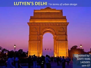
- 31. The King said "On this spot, in the central vista of the Capital of India, there will stand a Memorial Archway, designed to keep" in the thoughts of future generations "the glorious sacrifice of the officers and men of the Indian Army who fought and fell". •It is a replica of Arc De’Trompe in France. CANOPY- Lutyens used four Delhi Order columns to support the domed canopy and its chajja. Under the canopy having the Royal Coat of Arms. INDIA GATE
- 32. JANTAR MANTAR- The Jantar Mantar is an equinoctial sundial, consisting a gigantic triangular gnomon with the hypotenuse parallel to the Earth's axis. On either side of the gnomon is a quadrant of a circle, parallel to the plane of the equator. The primary purpose of the observatory was to compile astronomical tables, and to predict the times and movements of the sun, moon and planets. Now a days, its used as a place to express protest on political issues.
- 33. CONNAUGHT PLACE Designed by Sir Robert Russel. The Connaught Place is a large, circular commercial area in New Delhi, modelled after the Royal Crescent in England. Connaught Place is one of the largest financial, commercial and business centers in New Delhi, India. It is often abbreviated to CP .It was developed as a showpiece of Lutyens' Delhi with a prominent Central Business District. NIGHT VIEW FROM THE STREET
- 35. Connaught Place had only two floors, which made almost a complete circle intended to commercial establishments on the ground with residential space on the first floor. The circle was eventually designed with two concentric circles, creating an Inner Circle, Middle Circle and the Outer Circle with seven roads radiating from a circular central park. ARIEL VIEW OF CANNAUGHT PLACE CENTRAL PARK
- 36. URBAN NODES-
- 37. LUTYEN’S BUNGALOW ZONE “LBZ- DELHI’S HOTTEST REAL STATE HUB” • Located in the heart of the city with wide and green open spaces. • Cover- 3000 acres, approx- 1.5% of the landmass of Delhi. • Having about 1000 bungalows, out of which 65-70 are for private use. • The rest is used by ministers and other government officials. • Billionaire zone. • Prices reach upto 600 crores. • Some bungalows look into the nearby Lodi garden. • LBZ density= 14-15 people per acre. • East Delhi= 1100-1600 people per acre.
- 39. • Designed with aesthetics in mind, the zone was kept intact and devoid of any new development for several decades, even as the city around it grew in leaps and bounds. • No high rises, no basements and no changes in the construction of the bungalows in the entire zone. An old spiral staircase in LBZ, showing despite its lack of modern amenities, the area is kept preserved.
- 40. • Bungalow in Safdurjung lane , its garden has won many award for its fantastic landscaping.
- 41. MAJOR ROAD NETWORKS IN THE CITY •Edwin Lutyens had initially designed new Delhi with all the street crossing at right angles. •The road network consisted of diagonals and radials shape and at 30 degree or 60 degree angles to the main axis, which forming triangles and hexagons. •The design of road network was capable of accommodating 6000 vehicles.
- 42. • Delhi is predominantly dependent on road transport, with the railways catering to only about 1% of the local traffic. • Buses cater to 62% of the total traffic while personal vehicles account for the balance 37%. Although, buses constitute only 1.1% of the total number of vehicles. • Among personalized vehicles, motor cycles and scooters comprise about two third of the total number of vehicles in Delhi, while cars and jeeps account for one fourth of the total vehicles.
- 43. RAIL AND METRO NETWORK •The ring rail network in Delhi is grossly underutilized. •The railways catering to only about 1% of the local traffic.
- 44. AIRWAYS INDIRA GANDHI INTERNATIONAL AIRPORT •It is India's and South Asia's largest aviation hub, with a current capacity of handling more than 40 million passengers. •Approximately 80 airlines serve this airport.
- 45. COMMON PEOPLE IN AN IMPERIAL CAPITAL
- 46. PEOPLE AND THE CITY
- 47. HOUSING FOR COMMON PEOPLE- • Total no of households- 39.48 lakhs. • Urban- 97.78% (size- 4.39) • Rural- 2.23% (size-4.93) • Pucca houses- 99.10% • Semi-Pucca- 0.68% • Kutcha-0.22% • Independent houses- 51.11% • Flat type- 46.51% • AMENITIES- • WATER- exclusive use- 62%, Shared-17.16%, Government provision- 17.03% • VENTILATION- Good-52.96%, Satisfactory- 40.02%, Bad- 7.02%. • A major expansion started on partition of the country in 1947 with the huge number of refugees coming to settle in Delhi. • Migration started to this city of opportunities and availabilities from adjoining States of UP, Haryana, and Rajasthan for employment. • Delhi Development Act, 1957, was notified for proper development of this city according to a Master Plan and DDA was given this job.
- 48. SLUMS IN DELHI Bhalswa Slum Delhi
- 49. ECONOMY: • Delhi received over 3.2 million domestic and international tourists in 2010-11. • IT SECTOR- Delhi is one of the major hubs for IT sector along with Bangalore, Hyderabad, Chennai, and Mumbai-Pune. The city, with its large population of well educated work force, is ideally positioned to attain the pre-eminent position for providing workers for this fast growth sector. However, there is need for undertaking major capacity building exercise in consonance with the requirements of this sector. • DELHI WITH MILLION PLUS POPULATION HAS ONE OF THE FASTEST GROWING ECONOMIES IN INDIA. • WITH 15% AVERAGE COMPOUND GROWTH RATE DELHI'S ECONOMY IS DRIVEN BY THE SERVICE SECTOR. • ITS 78% OF GSDP IS BECAUSE OF SERVICE SECTOR WHICH PROVIDE EMPLOYMENT TO 58% OF LABOUR CLASS.
- 50. POLLUTION AND SMOG, CROWD, CONJESTION, TRAFFIC PROBLEMS
- 51. PROBLEMS : • In this whole process almost no attention was paid to the problems of Old Delhi. Due to the creation of New Delhi, Old Delhi experienced a 28% surge in population from 1916-1926 resulting in the spilling over of the population from inside the walled city to the Paharganj area, whose restructuring was later abandoned by Lutyens due to resource constraints. • Also, no provision of housing was premeditated for the large no. of skilled and unskilled workers which immigrated in for the construction work of New Delhi. • This negligence of the planners towards Old Delhi resulted in its transformation to a large slum area through deterioration and dilapidation. • The traffic- • 89 lakhs vehicles run on Delhi roads and an additional 2 lakh enter the city from outside every day, adding to the congestion. • Researchers say- unless immediate actions are taken to unclog its roads, Delhi may find it crawling at 5kmph- the average speed of a human walking- in the next ten years. • So, the focus is on encouraging people to use public transport by making it comfortable and easily accessible. • The results are clear; traffic congestion has resulted in drastically reduced traffic speeds, often as low as 10km/h. • If the city was designed so as to encourage mixed usage of the roads, there might have been more pedestrian movement discouraging criminal activities. The capital is not considered very safe for women for this reason.
- 52. THANK YOU NIGHT VIEW OF PARLIAMENT HOUSE
Editor's Notes
- Kelvin Lynch- American urban planner and author of the book- “Image of the city”, “Good City Form”. “The view from the road”, “what time is this place”, “site planning”, “Washing Away”, “Melted Grilled Cheese”. Student of F.L. Wright. “Districts are structured with nodes, defined by edges, penetrated by paths and sprinkled with landmarks. Elements regularly overlap one another.”- Kelvin Lynch
- We need sources for these images
- I don’t get this part. Should It even be here?
- Inaugurated in February 2006, the Musical Garden was President A.P.J. Abdul Kalam’s initiative. It is an example of human creativity through contact between music and science. Set up in the President’s Estate in an area that was earlier used as a nursery, the Musical Garden has three large water fountains that demonstrate digital electronics, electromagnetism, hydro dynamics and hydrostatics. The music is digitized and the audio system fed through computerized programme controller. Surrounded by a tennis court, bio-diversity park, the Bonsai Garden and the Herbal Garden on all sides, this Musical Garden provides liveliness to the area by breaking its tranquility. One can often spot the national bird enjoying in the premises of this garden. The musical fountains perfectly synchronize with classical tunes of shehnai, veena and patriotic songs like Vande Mataram. The scintillating lights with a range of colours from white to red make the whole experience magical.
- These four Dominion Columns which were presented by Australia, Canada, New Zealand and South Africa were a gesture of friendship and unity among the Dominions within the British Empire. On top of each Column is a bronze ship symbolic of the Empire's ocean links and the emblem of each Dominions is marked on each Column.
- LANDARKS- They are another type of point reference (as nodes), however in this case the observer can’t enter within them. Usually they are simply defined physical objects like statues, buildings, signs, stores or even a mountain. They are identified by singling them out from a host of possibilities. Ex- India Gate, Qutub Minar.
- The strategic spots in a city into which an observer can enter, and which are the intensive foci to and from which he is travelling. Conceptually, they occur as small points in a city image, but in reality they are large squares, traffic rotaries, extended linear shapes or even entire central districts at the city level.
- Lutyens Bungalow Zone (LBZ) is the area spread over 2,800-hectare area with bungalows (houses) for government officials and their administrative offices, during the British Raj. The zone stretches up to Lodhi Road in the south.