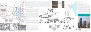
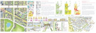
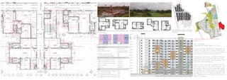
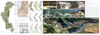
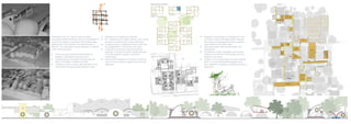
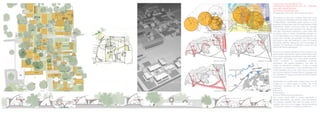
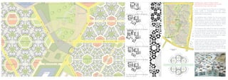
ACADEMIC PROFFESSIONAL
ANALYSIS AND PLANNING URBAN DESIGN ARCHITECTURE ILLUSTRATION & GRAPHICSTHESIS URBAN DESIGN HOUSING
KCLUBS
Background study for commercial landuse
Kuwait.
Client: Kuwait Municipality; State of Kuwait.
Masterplan Draft for KMPR 2040
The purpose of the study is to provide a robust analysis
of the supply and demand for commercial facilities
(retail, offices, hotel and leisure) across Kuwait through
to 2040, and to develop recommendations for changes
to planning standards and building regulations related to
commercial activity. The study will form a key piece of
background evidence to support the upcoming revision
to the new national Kuwait Master Plan, which will
replace the Third Kuwait Master Plan Review (3KMPR).
It is anticipated that work on the new Kuwait Master
Plan will commence in 2014. The study covers the
entire state of Kuwait including Kuwait City, the wider
Metropolitan Area and the planned Sub Regions.
“At present Offices, retail and hotels seem to undergo
substantial systemic adaptation to accommodate
the fast change of lifestyle associated with a world
embedded in smart technology. There is probably a
bigger evolutionary trend in building systems than the
architecture itself. Technology advances are observed
across the workplace, retailing and hospitality sectors
with substantial impact on internal space planning.
In the near future smart technology enabled building
systems are expected to evolve and create substantial
impact on future typologies.
Virtual and personalised environments seem to be the
primary focus of evolutionary design. The architectural
evolution of the office and hotel buildings remains a
response to the variations in programme or context. A
deeper typological evolution at the architectural could
not be traced within the limited scope of this study.
The retail typology, however, seems to be emerging at
a typological level and newer mixes are being tried
out. Retail and to some extent hospitality is heavily
dependent on cultural traits and substantial local
variations can be observed, especially in the unbranded
and boutique category. Kuwait by virtue of its unique
cultural context might be in a position to leverage this
advantage and come up with newer formats suitable for
the market.
Sustainability is another central theme across disciplines.
For offices there is a greater emphasis on narrower floor
plates, day lighting and natural ventilation. The concept
can be applied to retail and hotels as well but they may
not undergo the same typological evolution as the office
typology primarily due to the relatively complex nature of
the functions.
Parametric design similarly is another driver for
typological evolution and may have a similar impact as
sustainability.
In Kuwait there is a new consciousness towards a new
economy after the oil resources are exhausted. New
projects like the Madinat Al-Hareer (city of silk) located
in Subiya is pitched as a business and leisure centric
development. Such developments may allow the
emergence of new evolved retail and hospitality formats
in Kuwait. In the midterm the prospect of the oil economy
seems to be good which will favour expansion outside
the metropolitan core. New commercial typologies
suitable to a suburban context are expected to evolve.
However in the long term an inevitable energy crisis
may lead to a more sustainable development pattern
in Kuwait. This should coincide with the emergence
of compact inner city commercial formats to suit the
climatic and cultural traits of Kuwait.”
Kuwait Commercial Land Use Background Study
Final Report September 2015
NAYA RAIPUR SECTOR 7,15,16
Chattisgarh, India
Utilizing space and water as socio-economic resources
Client: Naya Raipur Development Authority
Masterplanning & Landscape - 808 Acres
The masterplan is for the development of three new
residential sectors part of the Naya Raipur new city.
The three sectors form the first arrival point from the
airport towards the city and a BRT route runs along
Sector 7 in the north and then between Sector 15 &
16 in the south.
There are a number of existing natural features on site
which have been retained and enhanced within the
masterplan. The plan is a mix of a high density TOD
influenced zone around the BRT route with a number of
mixed use functions, and pedestrian routes and activi-
ties; with a mid to lower density of residential uses at
the northern and eastern edges.
Integrated Accessibility System
Including Bus Rapid Transit (BRT) with high density
mixed use; pedestrian and cycling networks and city
wide rail systems
Compact and Connected, and Walkable
“Iconic Gateway”, which forms the entrance of the city,
comprises of a series of steel spheres woven with silk
placed over a green landscaped podium. There are
a number of different spaces along the visual corridor
providing the backdrop for various functions and
activities and the sectors have been masterplanned to
be completely pedestrian and cycle friendly.
A pedestrian boulevard originates from the Iconic
gateway and connects the prominent open spaces,
natural features as well as the amenities of all the 3
sectors. The Pedestrian boulevard ends at the ‘visual
corridor’- A city level promenade that links visually and
physically to the Capitol building.
Possible typologies for built fabric in the landuse. Built-open morphology in response to the fostered context.
Cluster Efficiency
Courtyard Size 26.22 x 18.66 m
Number of Units per cluster varying from 9-19 units
per cluster for Phase 1
FSI Efficiency (carpet area / FSI) 66%
Floor Efficiency (Sale Area/ Net BUA) 99%
Summary for 523663 F.S.I. to be consumed (all areas in sqmt)
Pocket - A - F.S.I area (G+11) Phase 2 153797.97
Pocket - B - F.S.I area (G+11) Phase 2 197030.69
Pocket - C - F.S.I area (G+12) Phase 1 173625.14
TOTAL - F.S.I AREA 524453.80
TARGET F.S.I 523663.00
Units
Total number of Units (Phase 1+ Phase 2) 10681
Total number of Units (Phase 1) 3180
No. of 1BHK units for Phase 1 @ 31 sqmt 2018
No. of 2BHK units for Phase 1 @ 50 sqmt 1162
One Bedroom unit typology variation with an approximate area under 30 square meters.
Typical street elevation as along the media roads between pockets.
Sector masterplan for a total of 11,000 units
segregated into three pockets to be executed
in two phases.
Two Bedroom unit typology variation with an approximate area under
50 square meters.
Typical courtyard section
SOCIAL HOUSING AT SECTOR: 10 PALAVA
Mumbai, India
Client: Lodha group
Masterplanning & Building Design- 29.72 acres
A social housing to be handed over to the Development
Authority with a built area of 5.2M sqft based on the
overall land area development of 650 acre under Mega
City Development policy as per the Government.
A development that fits in the economics of affordable
housing to be done in two phases with 30 per cent to
be executed in the first phase. The second phase to be
developed in pre-fab technology.
Modules of units have been so developed that they
repeat themselves and are flexible enough to suit
all possible conditions ensuring appropriate daylight
and ventilation for individual locations. The modules
are organised into a courtyard lattice intercepted with
openings and cut-outs to create lung spaces for the
built. Optimization of the floor plate is done to achieve
efficiency in numbers.
FFL 0.000 m
Level Exit level
FFL 0.450 m
Level 00
FFL 4.650 m
Level 01
FFL 8.250 m
Level 02
DEF
FFL 15.600 m
Level T.O. Truss
3
1220 1220 1220 1
FFL 11.300 m
Level 04
305036004200450
765
15600
1220122012201220REM
11220REM
INDIAN INSTITUTE OF TECHNOLOGY
Mandi, India
Masterplanning, Building Design, Landscape
Architecture & Sustainability Consulting -538 acres
Phase 1 completed- 2014
Masterplan and detailed design for a new “eco campus”
on the outskirts of Mandi, India, for the Indian Institute of
Technology. The layout of the 230-hectare (570-acre)
campus responds to the microclimate and topography
of the steep site, located in partially forested hills in the
western Himalayan region. Phase I includes shared
laboratories and workshops situated on various levels
and connected via pedestrian bridges. A market square
forms the heart of the campus and creates a place
to encourage social interaction and celebration. The
housing is laid out in a village setting at higher elevations,
providing views. The various building typologies echo
the traditional Himalayan vernacular and strive toward a
new architecture for the region.
Buldability Constraints Opportunities
Overlapping uses
SpineMovementLanduse
Self contained parcelsSegregated uses
Landuse
Analysis
Conception
Santinketan has its on specific style and taste.
Developed amidst the Santhal precincts Santiniketan is
a vision that requires an approach that threads ideas,
development, and creativity in the sacred womb of
Birbhum. The hypothesis is plural statement of singular
under mentioned ideas:
• Evolving an eternal architectural experience
leading to self-likeliness and enjoyment.
• Creating spaces and places that advocate the
idea of minimalism, simplicity and truth.
• Creating an ‘Alloy of space’ with elements of man
and environment giving equal impetus to each
• Habituate local material and expertise.
• Re - establishing the relation between user, space
and place promoting their humane behaviour
• Creating a young, unexampled environment with
an amalgamation of the built and the open.
• Creating an environment less dominated by
buildings. A simple and holistic design approach
using the simplest possible construction
methodology.
• Reincarnation thereafter incorporation of the folk
style in art and sculpture together with the local
aesthetics.
• Integration of landscape and buildings from the
very basic fundamental stage relation between
the physical and geographical factors creating
opportunities for the public realm
• Using appropriate methods that paves rural
development.
• Considering context, topography and ecology
creating an environment that benefits and is an
addition to the nature.
• Creation of an overall sculpture through buildings
which is not only aesthetically pleasant but is
also a definition to aesthetic sensitivity and artist’s
expression.
Residential Clusters
Thesis studio, Final semester B. Arch
SANTINIKETAN MASTERPLAN AND RE – BUILDING
KALA AND SANGIT BHAVAN
Santiniketan, West Bengal, India
Amalgamation of the built- environment with nature
The search for one such institution finds itself under
the canopies of Santiniketan and the ideals and values
of Rabindranath. Santiniketan gains impetus not only
because of its association with the noble laureate of India
Rabindranath Tagore commonly known as “Gurudev
“ or the teacher but also because of its specific style
and taste. Santiniketan represents a vision rather than
just being a place in history. Santiniketan emerges out
as the ideal situation for an all-round development of a
person both mentally and spiritually. The ideal of man
and nature is very well observed in here. It is freeing,
exempting, relieving, relaxing and acts as a catalyst to
creativity. The philosophy of solitude in crowd can very
well be felt here at Santiniketan.
As one of the earliest educators to think in terms of the
global village, Rabindranath Tagore’s educational model
has a unique sensitivity and aptness for education within
multi-racial, multi-lingual and multi-cultural situations,
amidst conditions of acknowledged economic
discrepancy and political imbalance. This was not
merely an educational institution - it was a cultural
confluence, an experiment in rural reconstruction and
environmentalism and at the same time a confluence
and coming together of myriad cultures, languages and
the culmination of Tagore’s principles of internationalism
and universalism.
Santiniketan as a global idea remains intact but the
thought is in a current phase of decline. The under
mentioned somewhat kill the Santiniketan once
perceived.
• Ignorance
• Urbanization
• Loss of identity and facing extinction.
The current turmoil offers a unique opportunity to
reinvent Santiniketan, the ashram, and Visva-Bharati,
the university, separate their roles and goals, and re-
establish them as a much bigger cultural-educational
complex that could be, in prestige and attraction.
Vehicular movement
10 minute walking radius in the university10 minute walking radius in the Town
Pedestrian movement
Urbanization trends
Urban Design studio, Final year B.Arch
AGRO CENTRIC URBAN DESIGN INTERVENTION
Dwarka Metro Station, New Delhi, India
A combination of techniques that result in a holistic
outcome with each permutation and combination
for opportunities to enhance the regional and local
landscape with waterways that provide recreational, bio
diverse and wildlife spaces an including
• Rerouting the natural drain to original contoured
course along with the development of depressions
along it into water reservoirs
• Creating opportunities for rural development
through water based activities, technical training
and research promoting social equity and financial
gain.
• Development of agro centric spots and setting up
model villages to promote agro tourism.
• Strengthening of the transport network through high
capacity corridors to industrial zones, concentric
ring roads for connectivity and By-pass routes to
decongest.
• Limiting Urbanization through redevelopment
schemes, urban landscape and planting
• Sewerage and waste water management through
infrastructural methods of STP, catchments for
domestic dis-charges, etc. and reuse to develop
irrigation networks.
Water sensitive urban design as the integration of urban
planning and development with the management,
protection and conservation of the water cycle as a
whole not only at the local and precinct level but also at
the greater context that broadly includes
• Protection of natural systems - protect and enhance
water systems within urban developments
• Protect water quality - improve the quality of water
draining from urban developments into receiving
environment
• Reduce run-off and peak flows reduce peak
flows from urban development by local detention
measures and minimising impervious areas
• The integration of concepts and technologies into
urban fabric such as grassed or vegetated Swales
as primary and conveyance function
• Filtration trenches as primary treatment and
conveyance and detention options
• Bio retention systems as secondary treatment,
conveyance, detention and retention functions
(through filtration)
• Wetlands as tertiary treatment system, storage,
detention, possible re-use options
• Rainwater banks using storm water as a resource
not a nuisance detention retention a substitute for
potable supply in garden irrigation car washing
toilet flushing etc.
• Grey water reuse as collect from household,
primary treatment on site reuse for external irrigation
or internal toilet flushing options
• Rain gardens, rooftop greening, urban forests as
they provide natural vegetated features of aesthetic
value and provide treatment by filtering storm water
• Filtration/retention basins as integrated nitration
and retention basins in public open spaces
• Networked public open spaces as they join public
spaces between community nodes.
• Drainage corridors used to direct run off to local
treatment ponds
• Natural drainage – maintain natural drainage lines
Level 00
Parking
Level 00
Level 01
425 Acres
or
170 Ha
Level 01Level 04
Level 02
Level 04
Level 06
Level 07
Level 08
g
Level 01
Level 04
One Bedroom apartment unit typology.
Two Bedroom apartment unit typology.
Three Bedroom apartment unit typology.
Four Bedroom apartment unit typology.
Lower floor layout.
Four Bedroom apartment unit typology.
Upper floor layout.
Housing studio, Seventh semester. B.Arch.
HIGH DENSITY MASS HOUSING FOR FUTURE
Rama Krishna Puram, New Delhi, India
A city not dominated by the Motorcar but Pedestrians
where mobility is characterized by mass transit
systems, the bicycle and finally the human foot creating
opportunities for place making.
The residential area is divided into two broad zones
connected by a public green space. The hexagonal
lattice establishes a hierarchal street patterns intercept
with commercial spaces and local shopping centers
missed with recreation functions to keep the streets
active and lively all through the day and afterhours.
The hexagonal attice allows for maximum penetration
into the development providing access to fire tender to
all possible spaces in the development. This promotes
a sense of social security and safety in the social
environment. Connecting lung space allows for spatial
interaction and community development.
Limited vehicular access and parking facilities with transit
nodes at entry points limit encroachment to the local
infrastructure. A walkable radius to all public functions
further advocates a pedestrian friendly development.
The low rise development allow for sustainable methods
reducing building costs and carbon footprint through
materials with lower embodied energy.
The gilded gateway at the northern
entrance to Silver Pagoda
Silver Pagoda
Near the low-strung riverfront of Phnom Penh,
the 19th-century Silver Pagoda lies within the
same complex as the Royal Palace and is a prom-
inent jewel of Phnom Penh’s squat skyline. With
its curlicued, golden roofs and tropical gardens,
the Silver Pagoda is a short walk from Sisowath
Quay, and is the perfect place to catch a little
calm away from the rush of the city.
C A M B O D I A A R E A B Y A R E A5 4 P H N O M P E N H 5 5
For hotels and restaurants in this region see pp210–12 and pp232–5
. Murals in the Gallery
The inner compound wall of the complex is beautifully
ornamented with vivid frescoes from the Reamker –
the Khmer version of the Indian epic, Ramayana.
Chedi of Suramarit
This stupa holds the ashes
of former king, Suramarit,
and his queen, Kossomak –
grandparents of the current
ruler, King Sihamoni.
. Wat Preah Keo
Named for its centerpiece,
a Baccarat crystal Buddha, Wat
Preah Keo (Temple of the Emerald
Buddha) is also famous for a
golden, life-sized Buddha and
miniature Buddhist statuary.
. Buddha’s Footprints
The Keong Preah Bath houses
the Buddha’s foot-prints.This
shrine is especially popular
with Cambodians and is
surrounded by fortune-tellers.
Equestrian Statue
King Norodom (r.1834–1904)
and Napoleon III were fast
friends – this statue of
Norodom in full Napoleon III
regalia is a parody of the
French King on his steed.
Royal Pavilion
The Dhammasala, which is also known as the
Royal Pavilion, is an open hall used by the
royal family as a reception area as well as
by Buddhist monks to recite religious texts.
The Mondap is a small library housing sacred
texts written on palm-tree fronds. Also of
interest are the statue of a bull’s head
wreathed in flowers and an exquisite
stained-glass window.
Dome-shaped chedis are
shrines or stupas contain-
ing the ashes of the dead.
Phnom Kailassa
contains a stylized
Buddha’s footprint
gifted by Sri Lanka.
South Entrance
North Entrance
Scale model
of Angkor Wat
VISITORS’ CHECKLIST
# 7:30–11am & 2–5pm daily.
& single ticket valid for both
Royal Palace & Silver Pagoda.
8 ^ inside Wat Preah Keo.
STAR SIGHTS
. Buddha Footprints
. Murals in the Gallery
. Wat Preah Keo
Decorative
tree
THE COMPLEX
Also known as the Wat Preah Keo, the Silver Pagoda is
named for its floor, which is inlaid with over 5,000 solid
silver tiles. The name also describes the complex that
houses the Buddha’s Footprints, the Mondap library, the
Reamker murals, and a number of royal family shrines.
Façade of Pavilion of Napoleon III and Throne Hall in the Royal Palace complex
Eyewitness Travel Guides, Dorling Kndersely Pvt Ltd.
ILLUSTRATIONS
One of the most widely used travel guides. The anchor
is the handrawn illustration depicting places of inter-
est. The artworks are divided into star sights and street
by streets. The star sights not only pins the reader to
masterpiece but also brings alive tourism for the reader.
The illustrations have been done in a period of six
weeks divided into four sub-parts namely First pencil,
Final pencil, Colour swatches and Final colour. The
artwork is intensely scrutinised based on the available
reference material such as on site images and web
research.
Stage 1 : First pencil This stage spans a week and en-
sures an proportionate scaled perspective for the entire
building/complex. The heights are based on assump-
tions based on in-depth analysis of various available
reference. This is an initial blocking and has the basic
volume frozen at the end of the stage. Stage 2 : Final
pencil The artwork moves on to a further detailed and
complicated stage. Critical details such as windows,
railings, roof texture etc is added to the artwork. A final
draft of the pencil work is achieved as a result of this
stage
Stage 3 : Colour sampling/swatches A colour strip is
prepared on a copy of the drawn final pencil. It is kept
in consideration that the strip so prepared exhibits
maximum possible elements in the colour. Major high-
lights are cross checked for authenticity and integrity.
Small tweaks are maintained in order to make the
artwork aesthetically pleasing and balanced. The colour
strip is a basic evaluation of the shades tones and tints
of the artwork.
Stage 4 : Final colour The final closure of the artwork.
The artwork is coloured with discussed shades,
colours and agreed textures. It is further detailed with
the help of a brush to ensure maximum resemblances
to the to original star sight. Compulsory technical
processing such as scanning, digital touchup etc is
kept into consideration to achieve perfection by all
means. Features such as shadows, landscape, trees
are added to detail. Pen work is used to add textures
at places. The final artwork so produced is set to be
placed in the spread with all its indicators and markers
Teatro Colón, Buenos Aires
A full page cutaway for the one of the best concert
venues in the world. Also known as the Columbus
theatre, its the main opera house and is situated in
the heart of the city the auditorium is considered to
have the very best of acoustic systems in the world.
The auditorium is horseshoe-shaped, has 2,487 seats
(slightly more than the Royal Opera House in Covent
Garden, London), standing room for 1,000 and a stage
which is 20 m wide, 15 m high and 20 m deep. The
exterior is intricately detailed with astounding mouldings
and cornices.
Niguliste Church, Tallinn, Estonia.
A full page cut star-sight illustration with an interior view
of the majestic arches and masterpieces of art. The
majestic Niguliste Church , a minute’s walk south of
Raekoja plats(Town Hall Square), is now used to stage
concerts and serves as a museum of religious art.
St. Peter and St. Paul’s Church, Vilnius, Lithuania
A full page cutaway star sight revealing the majesty of a
church considered a Lithuanian Baroque masterpiece.
The church is a basilica built on a traditional cross plan
with a lantern dome allowing extra light into its white
interior.
Wat Xieng Thong, Laos
A full page star-sight with an exploded view of the
royal funerary carriage house. Considered as the most
important symbol of the country’s heritage. The Wat
Xieng Thong or the Gold City Monastery, is notable for
the brilliant coloured-glass mosaics depicting standard
Buddhist iconography, scriptures and the Laos lifestyle
Silver Pagoda
A full page illustration of the Wat Preah Keo, the Silver
Pagoda star-sight in the proximity of the Phenom Penh
low strung riverfront forms an integral part of the city
skyline. The complex is intricately detailed with squat
roofs, motifs in gold and beautifully carved chedis
Ljubljana Castle
Full page illustration for the city’s most instantly
recognizable landmark from the 11th century. Built atop
a cone-shaped hill, the castle overlooks at terracotta
roofs along with the Alps in the background. The castle
houses a lively courtyard that acts as a recreation
comfort for the beholder. The viewing panorama is
anchored at the clock tower a 19th century structure.
Temple of the Tooth
The Temple of the Tooth, or Sri Dalada Maligawa,
Houses Sri Lanka’s most important Buddhist relic, the
Buddha’s tooth. Built in the 16th century, the original
temple stood at the heart of the Royal Palace complex.
Layout and graphic design
Bhopal2011 - Landscapes of Memory
This book is a documentation of the Bhopal2011:
workshop and symposium which was conducted
in Bhopal, India between 23rd January and 4th
February 2011. The action-research initiative explored
the significance of the Union Carbide industrial site
- its heritage as the site of the Bhopal gas tragedy,
its present condition as an abandoned industrial
brown field site and its relevance as a future site for
commemoration of the victims of the world’s greatest
industrial disaster. The event and this publication is the
result of the collaborative efforts of many individuals
and institutions.
Bhopal2011 - Landscapes of Memory is published
by SpaceMatters, India with Norwegian University
of Science and Technology (NTNU) supported by
Research Council of Norway University of Gothenburg,
Sweden modern Asian Architecture Network (mAAN)

Separate Pages

  • 1.
    ACADEMIC PROFFESSIONAL ANALYSIS ANDPLANNING URBAN DESIGN ARCHITECTURE ILLUSTRATION & GRAPHICSTHESIS URBAN DESIGN HOUSING
  • 2.
    KCLUBS Background study forcommercial landuse Kuwait. Client: Kuwait Municipality; State of Kuwait. Masterplan Draft for KMPR 2040 The purpose of the study is to provide a robust analysis of the supply and demand for commercial facilities (retail, offices, hotel and leisure) across Kuwait through to 2040, and to develop recommendations for changes to planning standards and building regulations related to commercial activity. The study will form a key piece of background evidence to support the upcoming revision to the new national Kuwait Master Plan, which will replace the Third Kuwait Master Plan Review (3KMPR). It is anticipated that work on the new Kuwait Master Plan will commence in 2014. The study covers the entire state of Kuwait including Kuwait City, the wider Metropolitan Area and the planned Sub Regions. “At present Offices, retail and hotels seem to undergo substantial systemic adaptation to accommodate the fast change of lifestyle associated with a world embedded in smart technology. There is probably a bigger evolutionary trend in building systems than the architecture itself. Technology advances are observed across the workplace, retailing and hospitality sectors with substantial impact on internal space planning. In the near future smart technology enabled building systems are expected to evolve and create substantial impact on future typologies. Virtual and personalised environments seem to be the primary focus of evolutionary design. The architectural evolution of the office and hotel buildings remains a response to the variations in programme or context. A deeper typological evolution at the architectural could not be traced within the limited scope of this study. The retail typology, however, seems to be emerging at a typological level and newer mixes are being tried out. Retail and to some extent hospitality is heavily dependent on cultural traits and substantial local variations can be observed, especially in the unbranded and boutique category. Kuwait by virtue of its unique cultural context might be in a position to leverage this advantage and come up with newer formats suitable for the market. Sustainability is another central theme across disciplines. For offices there is a greater emphasis on narrower floor plates, day lighting and natural ventilation. The concept can be applied to retail and hotels as well but they may not undergo the same typological evolution as the office typology primarily due to the relatively complex nature of the functions. Parametric design similarly is another driver for typological evolution and may have a similar impact as sustainability. In Kuwait there is a new consciousness towards a new economy after the oil resources are exhausted. New projects like the Madinat Al-Hareer (city of silk) located in Subiya is pitched as a business and leisure centric development. Such developments may allow the emergence of new evolved retail and hospitality formats in Kuwait. In the midterm the prospect of the oil economy seems to be good which will favour expansion outside the metropolitan core. New commercial typologies suitable to a suburban context are expected to evolve. However in the long term an inevitable energy crisis may lead to a more sustainable development pattern in Kuwait. This should coincide with the emergence of compact inner city commercial formats to suit the climatic and cultural traits of Kuwait.” Kuwait Commercial Land Use Background Study Final Report September 2015
  • 3.
    NAYA RAIPUR SECTOR7,15,16 Chattisgarh, India Utilizing space and water as socio-economic resources Client: Naya Raipur Development Authority Masterplanning & Landscape - 808 Acres The masterplan is for the development of three new residential sectors part of the Naya Raipur new city. The three sectors form the first arrival point from the airport towards the city and a BRT route runs along Sector 7 in the north and then between Sector 15 & 16 in the south. There are a number of existing natural features on site which have been retained and enhanced within the masterplan. The plan is a mix of a high density TOD influenced zone around the BRT route with a number of mixed use functions, and pedestrian routes and activi- ties; with a mid to lower density of residential uses at the northern and eastern edges. Integrated Accessibility System Including Bus Rapid Transit (BRT) with high density mixed use; pedestrian and cycling networks and city wide rail systems Compact and Connected, and Walkable “Iconic Gateway”, which forms the entrance of the city, comprises of a series of steel spheres woven with silk placed over a green landscaped podium. There are a number of different spaces along the visual corridor providing the backdrop for various functions and activities and the sectors have been masterplanned to be completely pedestrian and cycle friendly. A pedestrian boulevard originates from the Iconic gateway and connects the prominent open spaces, natural features as well as the amenities of all the 3 sectors. The Pedestrian boulevard ends at the ‘visual corridor’- A city level promenade that links visually and physically to the Capitol building. Possible typologies for built fabric in the landuse. Built-open morphology in response to the fostered context.
  • 4.
    Cluster Efficiency Courtyard Size26.22 x 18.66 m Number of Units per cluster varying from 9-19 units per cluster for Phase 1 FSI Efficiency (carpet area / FSI) 66% Floor Efficiency (Sale Area/ Net BUA) 99% Summary for 523663 F.S.I. to be consumed (all areas in sqmt) Pocket - A - F.S.I area (G+11) Phase 2 153797.97 Pocket - B - F.S.I area (G+11) Phase 2 197030.69 Pocket - C - F.S.I area (G+12) Phase 1 173625.14 TOTAL - F.S.I AREA 524453.80 TARGET F.S.I 523663.00 Units Total number of Units (Phase 1+ Phase 2) 10681 Total number of Units (Phase 1) 3180 No. of 1BHK units for Phase 1 @ 31 sqmt 2018 No. of 2BHK units for Phase 1 @ 50 sqmt 1162 One Bedroom unit typology variation with an approximate area under 30 square meters. Typical street elevation as along the media roads between pockets. Sector masterplan for a total of 11,000 units segregated into three pockets to be executed in two phases. Two Bedroom unit typology variation with an approximate area under 50 square meters. Typical courtyard section SOCIAL HOUSING AT SECTOR: 10 PALAVA Mumbai, India Client: Lodha group Masterplanning & Building Design- 29.72 acres A social housing to be handed over to the Development Authority with a built area of 5.2M sqft based on the overall land area development of 650 acre under Mega City Development policy as per the Government. A development that fits in the economics of affordable housing to be done in two phases with 30 per cent to be executed in the first phase. The second phase to be developed in pre-fab technology. Modules of units have been so developed that they repeat themselves and are flexible enough to suit all possible conditions ensuring appropriate daylight and ventilation for individual locations. The modules are organised into a courtyard lattice intercepted with openings and cut-outs to create lung spaces for the built. Optimization of the floor plate is done to achieve efficiency in numbers.
  • 5.
    FFL 0.000 m LevelExit level FFL 0.450 m Level 00 FFL 4.650 m Level 01 FFL 8.250 m Level 02 DEF FFL 15.600 m Level T.O. Truss 3 1220 1220 1220 1 FFL 11.300 m Level 04 305036004200450 765 15600 1220122012201220REM 11220REM INDIAN INSTITUTE OF TECHNOLOGY Mandi, India Masterplanning, Building Design, Landscape Architecture & Sustainability Consulting -538 acres Phase 1 completed- 2014 Masterplan and detailed design for a new “eco campus” on the outskirts of Mandi, India, for the Indian Institute of Technology. The layout of the 230-hectare (570-acre) campus responds to the microclimate and topography of the steep site, located in partially forested hills in the western Himalayan region. Phase I includes shared laboratories and workshops situated on various levels and connected via pedestrian bridges. A market square forms the heart of the campus and creates a place to encourage social interaction and celebration. The housing is laid out in a village setting at higher elevations, providing views. The various building typologies echo the traditional Himalayan vernacular and strive toward a new architecture for the region. Buldability Constraints Opportunities Overlapping uses SpineMovementLanduse Self contained parcelsSegregated uses Landuse Analysis Conception
  • 6.
    Santinketan has itson specific style and taste. Developed amidst the Santhal precincts Santiniketan is a vision that requires an approach that threads ideas, development, and creativity in the sacred womb of Birbhum. The hypothesis is plural statement of singular under mentioned ideas: • Evolving an eternal architectural experience leading to self-likeliness and enjoyment. • Creating spaces and places that advocate the idea of minimalism, simplicity and truth. • Creating an ‘Alloy of space’ with elements of man and environment giving equal impetus to each • Habituate local material and expertise. • Re - establishing the relation between user, space and place promoting their humane behaviour • Creating a young, unexampled environment with an amalgamation of the built and the open. • Creating an environment less dominated by buildings. A simple and holistic design approach using the simplest possible construction methodology. • Reincarnation thereafter incorporation of the folk style in art and sculpture together with the local aesthetics. • Integration of landscape and buildings from the very basic fundamental stage relation between the physical and geographical factors creating opportunities for the public realm • Using appropriate methods that paves rural development. • Considering context, topography and ecology creating an environment that benefits and is an addition to the nature. • Creation of an overall sculpture through buildings which is not only aesthetically pleasant but is also a definition to aesthetic sensitivity and artist’s expression. Residential Clusters
  • 7.
    Thesis studio, Finalsemester B. Arch SANTINIKETAN MASTERPLAN AND RE – BUILDING KALA AND SANGIT BHAVAN Santiniketan, West Bengal, India Amalgamation of the built- environment with nature The search for one such institution finds itself under the canopies of Santiniketan and the ideals and values of Rabindranath. Santiniketan gains impetus not only because of its association with the noble laureate of India Rabindranath Tagore commonly known as “Gurudev “ or the teacher but also because of its specific style and taste. Santiniketan represents a vision rather than just being a place in history. Santiniketan emerges out as the ideal situation for an all-round development of a person both mentally and spiritually. The ideal of man and nature is very well observed in here. It is freeing, exempting, relieving, relaxing and acts as a catalyst to creativity. The philosophy of solitude in crowd can very well be felt here at Santiniketan. As one of the earliest educators to think in terms of the global village, Rabindranath Tagore’s educational model has a unique sensitivity and aptness for education within multi-racial, multi-lingual and multi-cultural situations, amidst conditions of acknowledged economic discrepancy and political imbalance. This was not merely an educational institution - it was a cultural confluence, an experiment in rural reconstruction and environmentalism and at the same time a confluence and coming together of myriad cultures, languages and the culmination of Tagore’s principles of internationalism and universalism. Santiniketan as a global idea remains intact but the thought is in a current phase of decline. The under mentioned somewhat kill the Santiniketan once perceived. • Ignorance • Urbanization • Loss of identity and facing extinction. The current turmoil offers a unique opportunity to reinvent Santiniketan, the ashram, and Visva-Bharati, the university, separate their roles and goals, and re- establish them as a much bigger cultural-educational complex that could be, in prestige and attraction. Vehicular movement 10 minute walking radius in the university10 minute walking radius in the Town Pedestrian movement Urbanization trends
  • 8.
    Urban Design studio,Final year B.Arch AGRO CENTRIC URBAN DESIGN INTERVENTION Dwarka Metro Station, New Delhi, India A combination of techniques that result in a holistic outcome with each permutation and combination for opportunities to enhance the regional and local landscape with waterways that provide recreational, bio diverse and wildlife spaces an including • Rerouting the natural drain to original contoured course along with the development of depressions along it into water reservoirs • Creating opportunities for rural development through water based activities, technical training and research promoting social equity and financial gain. • Development of agro centric spots and setting up model villages to promote agro tourism. • Strengthening of the transport network through high capacity corridors to industrial zones, concentric ring roads for connectivity and By-pass routes to decongest. • Limiting Urbanization through redevelopment schemes, urban landscape and planting • Sewerage and waste water management through infrastructural methods of STP, catchments for domestic dis-charges, etc. and reuse to develop irrigation networks. Water sensitive urban design as the integration of urban planning and development with the management, protection and conservation of the water cycle as a whole not only at the local and precinct level but also at the greater context that broadly includes • Protection of natural systems - protect and enhance water systems within urban developments • Protect water quality - improve the quality of water draining from urban developments into receiving environment • Reduce run-off and peak flows reduce peak flows from urban development by local detention measures and minimising impervious areas • The integration of concepts and technologies into urban fabric such as grassed or vegetated Swales as primary and conveyance function • Filtration trenches as primary treatment and conveyance and detention options • Bio retention systems as secondary treatment, conveyance, detention and retention functions (through filtration) • Wetlands as tertiary treatment system, storage, detention, possible re-use options • Rainwater banks using storm water as a resource not a nuisance detention retention a substitute for potable supply in garden irrigation car washing toilet flushing etc. • Grey water reuse as collect from household, primary treatment on site reuse for external irrigation or internal toilet flushing options • Rain gardens, rooftop greening, urban forests as they provide natural vegetated features of aesthetic value and provide treatment by filtering storm water • Filtration/retention basins as integrated nitration and retention basins in public open spaces • Networked public open spaces as they join public spaces between community nodes. • Drainage corridors used to direct run off to local treatment ponds • Natural drainage – maintain natural drainage lines Level 00 Parking Level 00 Level 01 425 Acres or 170 Ha Level 01Level 04 Level 02 Level 04 Level 06 Level 07 Level 08 g Level 01 Level 04
  • 9.
    One Bedroom apartmentunit typology. Two Bedroom apartment unit typology. Three Bedroom apartment unit typology. Four Bedroom apartment unit typology. Lower floor layout. Four Bedroom apartment unit typology. Upper floor layout. Housing studio, Seventh semester. B.Arch. HIGH DENSITY MASS HOUSING FOR FUTURE Rama Krishna Puram, New Delhi, India A city not dominated by the Motorcar but Pedestrians where mobility is characterized by mass transit systems, the bicycle and finally the human foot creating opportunities for place making. The residential area is divided into two broad zones connected by a public green space. The hexagonal lattice establishes a hierarchal street patterns intercept with commercial spaces and local shopping centers missed with recreation functions to keep the streets active and lively all through the day and afterhours. The hexagonal attice allows for maximum penetration into the development providing access to fire tender to all possible spaces in the development. This promotes a sense of social security and safety in the social environment. Connecting lung space allows for spatial interaction and community development. Limited vehicular access and parking facilities with transit nodes at entry points limit encroachment to the local infrastructure. A walkable radius to all public functions further advocates a pedestrian friendly development. The low rise development allow for sustainable methods reducing building costs and carbon footprint through materials with lower embodied energy.
  • 10.
    The gilded gatewayat the northern entrance to Silver Pagoda Silver Pagoda Near the low-strung riverfront of Phnom Penh, the 19th-century Silver Pagoda lies within the same complex as the Royal Palace and is a prom- inent jewel of Phnom Penh’s squat skyline. With its curlicued, golden roofs and tropical gardens, the Silver Pagoda is a short walk from Sisowath Quay, and is the perfect place to catch a little calm away from the rush of the city. C A M B O D I A A R E A B Y A R E A5 4 P H N O M P E N H 5 5 For hotels and restaurants in this region see pp210–12 and pp232–5 . Murals in the Gallery The inner compound wall of the complex is beautifully ornamented with vivid frescoes from the Reamker – the Khmer version of the Indian epic, Ramayana. Chedi of Suramarit This stupa holds the ashes of former king, Suramarit, and his queen, Kossomak – grandparents of the current ruler, King Sihamoni. . Wat Preah Keo Named for its centerpiece, a Baccarat crystal Buddha, Wat Preah Keo (Temple of the Emerald Buddha) is also famous for a golden, life-sized Buddha and miniature Buddhist statuary. . Buddha’s Footprints The Keong Preah Bath houses the Buddha’s foot-prints.This shrine is especially popular with Cambodians and is surrounded by fortune-tellers. Equestrian Statue King Norodom (r.1834–1904) and Napoleon III were fast friends – this statue of Norodom in full Napoleon III regalia is a parody of the French King on his steed. Royal Pavilion The Dhammasala, which is also known as the Royal Pavilion, is an open hall used by the royal family as a reception area as well as by Buddhist monks to recite religious texts. The Mondap is a small library housing sacred texts written on palm-tree fronds. Also of interest are the statue of a bull’s head wreathed in flowers and an exquisite stained-glass window. Dome-shaped chedis are shrines or stupas contain- ing the ashes of the dead. Phnom Kailassa contains a stylized Buddha’s footprint gifted by Sri Lanka. South Entrance North Entrance Scale model of Angkor Wat VISITORS’ CHECKLIST # 7:30–11am & 2–5pm daily. & single ticket valid for both Royal Palace & Silver Pagoda. 8 ^ inside Wat Preah Keo. STAR SIGHTS . Buddha Footprints . Murals in the Gallery . Wat Preah Keo Decorative tree THE COMPLEX Also known as the Wat Preah Keo, the Silver Pagoda is named for its floor, which is inlaid with over 5,000 solid silver tiles. The name also describes the complex that houses the Buddha’s Footprints, the Mondap library, the Reamker murals, and a number of royal family shrines. Façade of Pavilion of Napoleon III and Throne Hall in the Royal Palace complex Eyewitness Travel Guides, Dorling Kndersely Pvt Ltd. ILLUSTRATIONS One of the most widely used travel guides. The anchor is the handrawn illustration depicting places of inter- est. The artworks are divided into star sights and street by streets. The star sights not only pins the reader to masterpiece but also brings alive tourism for the reader. The illustrations have been done in a period of six weeks divided into four sub-parts namely First pencil, Final pencil, Colour swatches and Final colour. The artwork is intensely scrutinised based on the available reference material such as on site images and web research. Stage 1 : First pencil This stage spans a week and en- sures an proportionate scaled perspective for the entire building/complex. The heights are based on assump- tions based on in-depth analysis of various available reference. This is an initial blocking and has the basic volume frozen at the end of the stage. Stage 2 : Final pencil The artwork moves on to a further detailed and complicated stage. Critical details such as windows, railings, roof texture etc is added to the artwork. A final draft of the pencil work is achieved as a result of this stage Stage 3 : Colour sampling/swatches A colour strip is prepared on a copy of the drawn final pencil. It is kept in consideration that the strip so prepared exhibits maximum possible elements in the colour. Major high- lights are cross checked for authenticity and integrity. Small tweaks are maintained in order to make the artwork aesthetically pleasing and balanced. The colour strip is a basic evaluation of the shades tones and tints of the artwork. Stage 4 : Final colour The final closure of the artwork. The artwork is coloured with discussed shades, colours and agreed textures. It is further detailed with the help of a brush to ensure maximum resemblances to the to original star sight. Compulsory technical processing such as scanning, digital touchup etc is kept into consideration to achieve perfection by all means. Features such as shadows, landscape, trees are added to detail. Pen work is used to add textures at places. The final artwork so produced is set to be placed in the spread with all its indicators and markers
  • 11.
    Teatro Colón, BuenosAires A full page cutaway for the one of the best concert venues in the world. Also known as the Columbus theatre, its the main opera house and is situated in the heart of the city the auditorium is considered to have the very best of acoustic systems in the world. The auditorium is horseshoe-shaped, has 2,487 seats (slightly more than the Royal Opera House in Covent Garden, London), standing room for 1,000 and a stage which is 20 m wide, 15 m high and 20 m deep. The exterior is intricately detailed with astounding mouldings and cornices. Niguliste Church, Tallinn, Estonia. A full page cut star-sight illustration with an interior view of the majestic arches and masterpieces of art. The majestic Niguliste Church , a minute’s walk south of Raekoja plats(Town Hall Square), is now used to stage concerts and serves as a museum of religious art. St. Peter and St. Paul’s Church, Vilnius, Lithuania A full page cutaway star sight revealing the majesty of a church considered a Lithuanian Baroque masterpiece. The church is a basilica built on a traditional cross plan with a lantern dome allowing extra light into its white interior. Wat Xieng Thong, Laos A full page star-sight with an exploded view of the royal funerary carriage house. Considered as the most important symbol of the country’s heritage. The Wat Xieng Thong or the Gold City Monastery, is notable for the brilliant coloured-glass mosaics depicting standard Buddhist iconography, scriptures and the Laos lifestyle Silver Pagoda A full page illustration of the Wat Preah Keo, the Silver Pagoda star-sight in the proximity of the Phenom Penh low strung riverfront forms an integral part of the city skyline. The complex is intricately detailed with squat roofs, motifs in gold and beautifully carved chedis Ljubljana Castle Full page illustration for the city’s most instantly recognizable landmark from the 11th century. Built atop a cone-shaped hill, the castle overlooks at terracotta roofs along with the Alps in the background. The castle houses a lively courtyard that acts as a recreation comfort for the beholder. The viewing panorama is anchored at the clock tower a 19th century structure. Temple of the Tooth The Temple of the Tooth, or Sri Dalada Maligawa, Houses Sri Lanka’s most important Buddhist relic, the Buddha’s tooth. Built in the 16th century, the original temple stood at the heart of the Royal Palace complex. Layout and graphic design Bhopal2011 - Landscapes of Memory This book is a documentation of the Bhopal2011: workshop and symposium which was conducted in Bhopal, India between 23rd January and 4th February 2011. The action-research initiative explored the significance of the Union Carbide industrial site - its heritage as the site of the Bhopal gas tragedy, its present condition as an abandoned industrial brown field site and its relevance as a future site for commemoration of the victims of the world’s greatest industrial disaster. The event and this publication is the result of the collaborative efforts of many individuals and institutions. Bhopal2011 - Landscapes of Memory is published by SpaceMatters, India with Norwegian University of Science and Technology (NTNU) supported by Research Council of Norway University of Gothenburg, Sweden modern Asian Architecture Network (mAAN)