IRJET- Space Technology on Erosion Histories of Earth and Mars
•
0 likes•11 views

This document discusses using space technology to analyze erosion histories on Earth and Mars by reconstructing ancient river channels. It proposes mapping channels identified in seismic data from the North Atlantic and Mars to model uplift rates over time. This could provide insights into mantle dynamics beneath the North Atlantic and test theories of early plate tectonics and water cycling on Mars. The methodology involves reconstructing drainage networks from terrain data, modeling river profiles, and inverting models to determine uplift histories that fit observed profiles. Analyzing erosion patterns in this way could improve understanding of geological processes on multiple planets.

Recommended
Recommended
More Related Content
What's hot
What's hot (20)
Similar to IRJET- Space Technology on Erosion Histories of Earth and Mars
Similar to IRJET- Space Technology on Erosion Histories of Earth and Mars (20)
More from IRJET Journal
More from IRJET Journal (20)
Recently uploaded
Recently uploaded (20)
IRJET- Space Technology on Erosion Histories of Earth and Mars
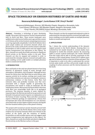
- 1. International Research Journal of Engineering and Technology (IRJET) e-ISSN: 2395-0056 Volume: 07 Issue: 03 | Mar 2020 www.irjet.net p-ISSN: 2395-0072 © 2020, IRJET | Impact Factor value: 7.34 | ISO 9001:2008 Certified Journal | Page 5415 SPACE TECHNOLOGY ON EROSION HISTORIES OF EARTH AND MARS Basavaraj Kallakutagar1, Lavin Kumar.V.M2,Viraj V Narthi3 1Basavaraj Kallakutagar, Director, NSS-Mumbai Chapter, Bangaluru, Karnataka, India 2Lavin Kumar.V.M Director, NSS-Mumbai Chapter, Banglore, Karnataka, India 3Viraj V Narthi, JTR (CBSCE) School, Mundargi, Karnataka, India ---------------------------------------------------------------------***---------------------------------------------------------------------- Abstract - Nowadays a technology of space developing rapidly. This project will reconstruct ancient channelspresent both on Earth and Mars. These ancient landscapes were uplifted and eroded several million yearsagoandthuscontain a rich history of the vertical motions and geological processes occurring regionally and globally. In the North Atlantic there exists ample evidence for terrestrial channels which once flowed on the surface of the Earth, and the existenceofbenthic foraminifera as well as pollen spores and coal suggest rapid marine transgressions and regressions in this region1. On Mars, channels are easily discernible and attest to significant fluvial activity on the Martian surface in the past. These channels can then be mapped and analyzed in order to understand the interplay between erosional and uplift rates, hence enabling current uplift models on multiple planetary bodies to tested and improved. 1. INTRODUCTION Mars and Earth are the only two planets known to have long histories of dynamical cycling of water through their atmosphere, lithosphere, and cryosphere. Although wehave known for thirty years that Mars had an early history with aqueous activity on its surface, exciting new results from current Mars missions are only now revealing the extensive sedimentary evidence of that history. Early Mars had extensive lakes and probably transient seas that were associated with a climate capable of generating the precipitation and runoff to sculpt its landscape and fill sedimentary basins. Well-preserved fluvial deltas showthat early Mars was surprisingly Earth like in its geological processes. The immense quantity of water implied for sequestering in the Martian permafrost (as ground ice) and beneath it (as ground water) requires an explanation as to the history of water recycling. These and other anomalous aspects of Martian geology are explained by a theory that incorporates the onset and termination of a core dynamo, associated with an early regime of plate tectonics duringthe first few hundred million years of the planet’s history. This project will reconstruct ancient channels present both on earth and mars In the North Atlantic there exists ample evidence for terrestrial channels which once flowed on the surface of the Earth, and the existence of benthic foraminifera as well as pollen spores and coal suggest rapid marine transgressions and regressions in this region1. On Mars, channels are easily discernible andattesttosignificant fluvial activity on the Martian surface in the past. These channels can then be mappedandanalysedinorderto understand the interplay between erosional andupliftrates, hence enabling current uplift models on multiple planetary bodies to tested and improved. 2. APPLICATIONS Fig. 1 shows the current understanding of the dynamic support present in the North Atlantic, showing that it is sustained by hot mantle beneath it; several studies have attempted to model this Icelandic plume2. By measuring uplift in ancient surficial landscapes, the results obtained from this study will be able to provide constraints on the dynamics of the Iceland plume around 50-55 million years ago and its behavior bothas a functionoftimeandspace.This is important in order to be able to understand the current tectonic plate model, and thus will provide insight into the coupling of surface processes and the internal dynamics of the Earth. Fig-1 Fig. 1
- 2. International Research Journal of Engineering and Technology (IRJET) e-ISSN: 2395-0056 Volume: 07 Issue: 03 | Mar 2020 www.irjet.net p-ISSN: 2395-0072 © 2020, IRJET | Impact Factor value: 7.34 | ISO 9001:2008 Certified Journal | Page 5416 i ) ii ) River profiles i v ) Total uplift ii i) Fig. 2 3. METHODOLOGY The fundamental principle on which this project is based is that the shape of a river can provide us with a direct and quantitative estimate for therate of uplift experiencedbythe area under study3. The following steps indicate the procedure which will be used for the project (see Fig. 2). i) The landscape will be reconstructed using seismic interpretation tools and as a result, a terrestrial channel system is predicted to be extracted from the data; ii) Drainage networks and patterns can then be reconstructed using flow routing algorithms; iii) Once this is done, longitudinal profiles (elevation as a function of distance) for every mapped river, as well as the upstream drainage area, can then be plotted; iv) The shape of a river profile can then be used as a function of the upliftrateforcingtheriverupwards and the erosion bringing the river downwards. As a result, is it possible to invert the problem, andthe geologically more interesting question can be posed: What uplift rate history best fits observed river profiles? 4. EARTH CHANNELS The terrestrial component of this project will take place in the Brassey Region near the East Shetland Platform. The mapping of the landscape for this project will be done using 3D reflection and well data provided by PGS. The current available dataset consists of a seismic volume, spanning an area of 9000 km2 and a depth of 5 km, and a total of 15 well logs provided by Statoil. Fig.3: The seismic interpretation softwareusedisPetrel and the mapping of drainage and flow algorithms will later be done using ArcGIS. A channel has been identified and mapped at ~1 km bellows the seabed (see Fig. 3). The feature displays various fluvial characteristics and has a relief of ~100m. 5. MARS CHANNELS This technique for solving for upliftusingdrainagenetworks is being applied in several places around the world. The model used in this study requires a river (current or ancient), that had running water at some point and an active geodynamic or a warm mantle which could have resulted in uplift of the crust. Although Mars is currently dry and cold,it could potentially have possessed these features, as evidenced by flow channels and volcanic structures. Fig. 4: The images shown to the left (Fig. 4) are of the Warrego Valles on southern Mars. The first image (4a) shows the channels obtained fromHRSCimagery, whereas in the second image (4b), a topographical gradient is used in
- 3. International Research Journal of Engineering and Technology (IRJET) e-ISSN: 2395-0056 Volume: 07 Issue: 03 | Mar 2020 www.irjet.net p-ISSN: 2395-0072 © 2020, IRJET | Impact Factor value: 7.34 | ISO 9001:2008 Certified Journal | Page 5417 order to determine the drainage patterns of the topography, simulating what surficial river flows on Mars could have resembled several millions of years ago. 6. CONCLUSION The foregoing holds that Mars, like Earth,ischaracterized by long-term cycles of water and rock (igneous, metamorphic, and sedimentary). These cyclic processes are intimatelytied to the evolution of the planetary lithosphere, atmosphere, and hydrosphere. However, the evolution of Mars wasmuch faster than that of Earth.Marsexperiencedandcompleted its plate-tectonic phase during the 400 to 500 Myr period prior to the late heavy bombardment while Earth remains in the plate tectonics evolutionary phase .Thus,thetheorystrongly follows the insight that the phenomenon of plate tectonics is not exhausted by a planetary sample ofone,butratherthatit is a natural consequence of the more general evolutionary sequence of a water-rich terrestrial planet. Mars formed its highlands/lowlands dichotomy, as Earth did, but it did so much more rapidly, and in the time interval betweentheend of its magma ocean and the disruption of the late heavy bombardment. It was latter that terminated plate tectonics, but it was also the latter that establishedthetransitionto the persistent superplume activity at Tharsis and Elysium. The hydrated lithosphere that was subducted to the Martian interior by its early plate-tectonic phase provides the reservoir that sustained the episodic hydrological activity through later Martian history that so clearly contradicts the HIDDEN hypothesis. 7. REFERENCES 1. Underhill, J. R. (2001). Controls on the genesis and prospectivity of Paleogene palaeogeomorphic traps, East Shetland Platform, UK North Sea. Marine and petroleum geology, 18(2), 259-281. 2. Rickers, F., Fichtner, A., & Trampert, J. (2013). The Iceland–Jan Mayen plume system and its impact on mantle dynamics in the North Atlantic region: Evidence from full- waveform inversion. Earth and Planetary Science Letters,367, 39-51. 3. Hartley, R. A., Roberts, G. G., White, N., & Richardson, C. (2011). Transient convective uplift of an ancient buried landscape. Nature Geoscience, 4(8), 562-565