Smart bus transportation system project report @ IICDC( India Innovation challenge design contest ) 2016-2017 conducted by Texas Instruments India and IIM bangalore
“Pay N Park” is aiming to be an online parking management agency. “Pay N Park” offers a wide range of products and services that will equip users to search for a parking space in a particular location and to book the available parking space using mobile/web internet devices.
Intelligent Bus Tracking System Using AndroidAM Publications
Intelligent bus tracking system using android is an application that tracks a bus and collects the distance to each station. Tracking system involves the installation of an electronic device in a bus, with an installed Android App on any smart phone to enable a user to track the bus location. There are two applications one for server and other for the client. The user can get flexibility of planning travel using the app, to decide on which bus to take or when to catch the bus. The waiting time of the user can be reduced. By using this application user get the information about buses, bus numbers, bus route, bus arrival and bus delay timing information etc [1]. It provides information about which bus coming to the stop. By the presently existing system we are dealing with three terminals, a device on bus, a device at bus stop and a device on the master bus stand so as to keep the track on the all city busses. By employing this tracking system the arrival of the bus is detected near the bus stop and also can be seen on the PC at the master bus stop. GSM modem can also transmit the bus information to the registered mobile numbers. Hence, we can control the bus traffic and can detect the arrival of particular bus at the bus stop.
RFID-based public transport ticketing systems
rely on widespread networks of RFID readers that locate
the user within the transport network in real time to be
able to verify whether he can travel at that time with the
ticket he holds. This paper presents a system that uses that
same RFID-based location information to give the user
navigation indications depending on his current location
provided that the user has indicated beforehand the places
he intends to visit. The system was designed to be costeffectively
deployable on the short term but open for easy
extension. This paper is based on ticketing and
identification of the passenger in the public transport. In
the metropolitan city like Mumbai, Kolkata we have a
severe malfunction of public transport and various
security problems. Firstly, there is a lot of confusion
between the passengers regarding fares which lead to
corruption, Secondly due to mismanagement of public
transport the passengers faces the problem of traffic jam,
thirdly nowadays we have severe security problems in
public transport due anti-social elements.The entire
network comprises of three modules; Base Station Module,
In-Bus Modules and Bus Stop Module. The base station
module consists of monitoring system which includes GSM
and a PC. The In-Bus Modules consists of two
Microcontrollers, GSM Modem, GPS, Zigbee, RFID, LCD
and infrared sensor. RFID for ticketing purpose, GSM,
GPS is used for mobile data transmission and tracking
location. The Zigbee module is also interfaced with the
microcontroller which is used to send the bus information
to bus stop and to get the information from the bus stop to
bus. The Bus Stop Module is fixed at every bus stop
consists of Zigbee node which is interfaced with the
Microcontroller.
Comparative study of user experience on mobile pedestrian navigation between ...IJECEIAES
Fast-paced mobile technology development has permitted augmented reality experiences to be delivered on mobile pedestrian navigation context. The fact that the more prevalent of this technology commonly will substituting the digital map visualization to present the geo-location information is still debatable. This paper comprises a report on a field study comparing about user experience when interacting with different modes of mobile electronic assistance in the context of pedestrian navigation interfaces which utilize location-based augmented reality (AR) and two-dimensional digital map to visualize the points of interest (POIs) location in the vicinity of the user. The study was conducted with two subsequent experiments in the Zhongli District, Taoyuan City, Taiwan. The study involved 10 participants aged between 22 and 28 years with different experiences in using smartphones and navigation systems. Navigation performance was measured based on a usability approach on pragmatic quality and hedonic quality like effectiveness (success rate of task completion), efficiency (task completion time) and satisfaction in real outdoor conditions. The evaluation findings have been cross-checked with the user’s personal comments. We aim at eliciting knowledge about user requirements related to mobile pedestrian interfaces and evaluating user experience from pragmatic and hedonic viewpoints. Results show that in the context of pedestrian navigation, digital map interfaces lead to significantly better navigation performance in pragmatic attributes in comparison to AR interfaces. Nevertheless, the study also reveals that location-based AR is more valued by participants in hedonic qualities and overall performance.
Gps Tracker with RFID | School Security | techlead-india
eTechSchoolBus is complete school bus security solution. According to a survey, it has been found that parents are extremely worried about their children when they are on the way to school in school bus. The key reason of worrying is increase in crime; rush driving of school bus driver etc. Hence the tracking of school bus is ultimate solution. eTechSchool Bus provides RFID based location updates of your children whether your child has reached school or not. GPS device installed in vehicle gives current location of school bus. eTechSchool Bus product is designed specifically for the real time movement tracking, knowing when students got picked or dropped from the bus. SMS alerts are sent to parents on the arrival of the bus as well as when a student is picked or dropped.
How it works?
Download Presentation
A smart card (nametag) is provided to each student. Smart Card contains student information. At the entrance of the bus, RFID card reader will be provided (Internally its connected with GPS Device). Students need to flash the smart card (nametag),
while entering into the bus at pick-up point (Pickup)
while leaving from bus at a school (Pickup)
while entering into the bus after school (Drop)
while leaving bus at drop point (Drop)
A sms will be sent in each of the above cases. Parents can check exact location of bus on online software of eTechSchool Bus. Individual UserID and password will be provided to parents. Parents will be able to check the bus location of their child only. User Id and password will also be provided to school administrators, so that they will be able to check location of all buses.
Features:
Live tracking ie. the system provides real-time location data that displays the movement of the bus along with the date and time stamp, direction, speed and number of students in the bus on a map.
For Parents: Track the child getting in/out of the bus and entering or leaving the School.
Many more alerts can be configured with the system in cases such as:
If their child/employee does not board the bus when it leaves from the school/office
If bus takes a halt between school and home
If the bus breaks down
If bus is deviated from it’s path
Emergency (Panic) Button
Supports multiusers
GPS device with internal battery back – up
Stores data upto 120 days
Regular and up-to-date reports of vehicles
Benefits:
Parents become aware on the whereabouts of the school bus
School management remains informed about location, speed of school bus with information of students travelling in bus
Parents remain informed about real time location of bus and pick – up and drop updates of their child via sms on mobile phones
Availability of Panic button to inform school administrators/bus controllers in case of emergency
Reporting on vehicle performance over user specified time interval
Remote Immobilization : Remotely stop your vehicle
Real time, multiple vehicle tracking for schools
Contact: Sagar
Build a prototype offering real-time SMS updates about a passenger bus location and ETA.
The hardware prototype is based on 8051 micro-processor with an embedded GPS and GSM module integrated with SMS (short messaging service).
Smart bus system pilot project (BUSKET)Minh S. Dao
BUSKET is a wireless system aimed at supporting the quality of bus transportation service in Brunei Darussalam. BUSKET exploits low-cost wireless technologies for the real-time estimation of the buses position throughout the road network and to communicate to the users when one bus approaches the bus stop. The goal of BUSKET is to make smarter the bus transportation system and to improve the user awareness about the status of the bus service. From the user perspective, BUSKET will reduce the waiting time of citizens at the bus stops, while from the bus management viewpoint will enable a more centralized and pervasive control of the whole transportation network. BUSKET will use commercial smartphones (already diffused among citizens) as well as low-cost wireless GPS sensors to enable the acquisition of position information and to communicate with the users.
BUSKET is the joint-research between UTB, ELEDIA, and AITI
This paper proposes development of an android app to improve the transportation services for
bus rental companies that lift Taibah University students. It intends to reduce the waiting time
for bus students, thereby to stimulate sharing of updated information between the bus drivers
and students. The application can run only on android devices. It would inform the students
about the exact time of arrival and departure of buses on route. This proposed app would
specifically be used by students and drivers of Taibah University. Any change in the scheduled
movement of the buses would be updated in the software. Regular alerts would be sent in case of
delays or cancelation of buses. Bus locations and routes are shown on dynamic maps using
Google maps. The application is designed and tested where the users assured that the
application gives the real time service and it is very helpful for them.
passSepnegceirasl. pIut rcpoonsesi sotns lionfe tbwuos tarancdkroinidg saypsptelimca tisio dnesv. eFloirpset da ptop lpicroavtiiodne tehseta rbelaisl hteims ec oinmfomrumnaitciaotnio onf bbeutswese eton
central server and bus system which is capable of providing real-time data (GPS coordinates) regarding the
current location of buses. Second application is student side application which displays the current location of the
bus on Google map along with the estimated time of arrival to the specified bus stop hence it saves the time of
students. Both the side applications provide dynamically updated timetable. Another important feature of both the
applications is emergency service through which call or alert messages can be simultaneously sent to college,
police and ambulance in case of accidents. Thus this is a cost effective, efficient system and helps students to
catch their buses at the proper time.
Prototypic Gps-Gsm Integration for Enhancing Public Transportation and Manage...IJERA Editor
This paper proposes and implements a solution for enhancing public transportation management services based on GPS and GSM. Travel time information is a vital component of many intelligent transportation systems (ITS) applications. In recent years, the number of vehicles in India has increased tremendously, leading to severe traffic congestion and pollution in urban areas, particularly during peak periods. A desirable strategy to deal with such issues is to shift more people from personal vehicles to public transport by providing better service (comfort, convenience and so on). In this proposed system we introduced advanced public transportation systems (APTS) for public service. Advanced public transportation systems (APTS) are one of the most important ITS applications, which can significantly improve the traffic situation in India. One such application will be to provide accurate information about bus arrivals to passengers, leading to reduced waiting times at bus stops. This needs a real-time data collection technique, a quick and reliable prediction technique to calculate the expected travel time based on real-time data and informing the passengers regarding the same. The scope of this proposed system is to use global positioning system data collected from public transportation buses on urban roadways in the city of Chennai, India, to predict travel times. The performance of the proposed system is found to be promising and expected to be valuable in the development of advanced public transportation systems (APTS) in India. The work presented here is one of the first attempts at real-time short-term prediction of travel time for ITS applications in Indian traffic conditions.
Intelligent Transportation Systems (ITS) can be defined as the application of advanced information and communications technology to surface transportation in order to achieve enhanced safety and mobility while reducing the environmental impact of transportation. The addition of wireless communications offers a powerful and transformative opportunity to establish transportation connectivity that further enables cooperative systems and dynamic data exchange using a broad range of advanced systems and technologies.
learn the basics of percentages topic in arithmetic section in Quantitative Ability . theory and examples of every concept are available in this presentation
Detail explanation about the HOQ ( House of quality ) concept in engineering ...Nt Arvind
while designing a new marketing based or feasibility product we have to look a proper understanding about the concepts of engineering design concepts
House of quality is also known as Quality function deployment
Philosophy and Introduction of Engineering Design Nt Arvind
Detail introduction and Philosophy of engineering design concepts
while designing a new marketing based or feasibility product we have to look a proper understanding about the concepts of engineering design concepts
Error Detection and correction concepts in Data communication and networksNt Arvind
single bit , burst error detection and correction in data communication networks , block coding ( hamming code , simple parity check code , Cyclic redundancy check-CRC , checksum , internet checksum etc
Switching concepts Data communication and networksNt Arvind
This slide explains you about the different types of sxitching networks like circuit switched network , datagram network , virtual circuit network , message switched network
Basics on different types operational amplifier (op-amp)Nt Arvind
*non-inverting op amp , inverting op amp , summing op amp , differential op amp , differentiator op-amp , integrator op-amp
*watch the below link for more more detailed information
https://youtu.be/MXClGTL3IOk
Acetabularia Information For Class 9 .docxvaibhavrinwa19
Acetabularia acetabulum is a single-celled green alga that in its vegetative state is morphologically differentiated into a basal rhizoid and an axially elongated stalk, which bears whorls of branching hairs. The single diploid nucleus resides in the rhizoid.
Model Attribute Check Company Auto PropertyCeline George
In Odoo, the multi-company feature allows you to manage multiple companies within a single Odoo database instance. Each company can have its own configurations while still sharing common resources such as products, customers, and suppliers.
Read| The latest issue of The Challenger is here! We are thrilled to announce that our school paper has qualified for the NATIONAL SCHOOLS PRESS CONFERENCE (NSPC) 2024. Thank you for your unwavering support and trust. Dive into the stories that made us stand out!
Welcome to TechSoup New Member Orientation and Q&A (May 2024).pdfTechSoup
In this webinar you will learn how your organization can access TechSoup's wide variety of product discount and donation programs. From hardware to software, we'll give you a tour of the tools available to help your nonprofit with productivity, collaboration, financial management, donor tracking, security, and more.
Introduction to AI for Nonprofits with Tapp NetworkTechSoup
Dive into the world of AI! Experts Jon Hill and Tareq Monaur will guide you through AI's role in enhancing nonprofit websites and basic marketing strategies, making it easy to understand and apply.
Operation “Blue Star” is the only event in the history of Independent India where the state went into war with its own people. Even after about 40 years it is not clear if it was culmination of states anger over people of the region, a political game of power or start of dictatorial chapter in the democratic setup.
The people of Punjab felt alienated from main stream due to denial of their just demands during a long democratic struggle since independence. As it happen all over the word, it led to militant struggle with great loss of lives of military, police and civilian personnel. Killing of Indira Gandhi and massacre of innocent Sikhs in Delhi and other India cities was also associated with this movement.
The Roman Empire A Historical Colossus.pdfkaushalkr1407
The Roman Empire, a vast and enduring power, stands as one of history's most remarkable civilizations, leaving an indelible imprint on the world. It emerged from the Roman Republic, transitioning into an imperial powerhouse under the leadership of Augustus Caesar in 27 BCE. This transformation marked the beginning of an era defined by unprecedented territorial expansion, architectural marvels, and profound cultural influence.
The empire's roots lie in the city of Rome, founded, according to legend, by Romulus in 753 BCE. Over centuries, Rome evolved from a small settlement to a formidable republic, characterized by a complex political system with elected officials and checks on power. However, internal strife, class conflicts, and military ambitions paved the way for the end of the Republic. Julius Caesar’s dictatorship and subsequent assassination in 44 BCE created a power vacuum, leading to a civil war. Octavian, later Augustus, emerged victorious, heralding the Roman Empire’s birth.
Under Augustus, the empire experienced the Pax Romana, a 200-year period of relative peace and stability. Augustus reformed the military, established efficient administrative systems, and initiated grand construction projects. The empire's borders expanded, encompassing territories from Britain to Egypt and from Spain to the Euphrates. Roman legions, renowned for their discipline and engineering prowess, secured and maintained these vast territories, building roads, fortifications, and cities that facilitated control and integration.
The Roman Empire’s society was hierarchical, with a rigid class system. At the top were the patricians, wealthy elites who held significant political power. Below them were the plebeians, free citizens with limited political influence, and the vast numbers of slaves who formed the backbone of the economy. The family unit was central, governed by the paterfamilias, the male head who held absolute authority.
Culturally, the Romans were eclectic, absorbing and adapting elements from the civilizations they encountered, particularly the Greeks. Roman art, literature, and philosophy reflected this synthesis, creating a rich cultural tapestry. Latin, the Roman language, became the lingua franca of the Western world, influencing numerous modern languages.
Roman architecture and engineering achievements were monumental. They perfected the arch, vault, and dome, constructing enduring structures like the Colosseum, Pantheon, and aqueducts. These engineering marvels not only showcased Roman ingenuity but also served practical purposes, from public entertainment to water supply.
Macroeconomics- Movie Location
This will be used as part of your Personal Professional Portfolio once graded.
Objective:
Prepare a presentation or a paper using research, basic comparative analysis, data organization and application of economic information. You will make an informed assessment of an economic climate outside of the United States to accomplish an entertainment industry objective.
June 3, 2024 Anti-Semitism Letter Sent to MIT President Kornbluth and MIT Cor...Levi Shapiro
Letter from the Congress of the United States regarding Anti-Semitism sent June 3rd to MIT President Sally Kornbluth, MIT Corp Chair, Mark Gorenberg
Dear Dr. Kornbluth and Mr. Gorenberg,
The US House of Representatives is deeply concerned by ongoing and pervasive acts of antisemitic
harassment and intimidation at the Massachusetts Institute of Technology (MIT). Failing to act decisively to ensure a safe learning environment for all students would be a grave dereliction of your responsibilities as President of MIT and Chair of the MIT Corporation.
This Congress will not stand idly by and allow an environment hostile to Jewish students to persist. The House believes that your institution is in violation of Title VI of the Civil Rights Act, and the inability or
unwillingness to rectify this violation through action requires accountability.
Postsecondary education is a unique opportunity for students to learn and have their ideas and beliefs challenged. However, universities receiving hundreds of millions of federal funds annually have denied
students that opportunity and have been hijacked to become venues for the promotion of terrorism, antisemitic harassment and intimidation, unlawful encampments, and in some cases, assaults and riots.
The House of Representatives will not countenance the use of federal funds to indoctrinate students into hateful, antisemitic, anti-American supporters of terrorism. Investigations into campus antisemitism by the Committee on Education and the Workforce and the Committee on Ways and Means have been expanded into a Congress-wide probe across all relevant jurisdictions to address this national crisis. The undersigned Committees will conduct oversight into the use of federal funds at MIT and its learning environment under authorities granted to each Committee.
• The Committee on Education and the Workforce has been investigating your institution since December 7, 2023. The Committee has broad jurisdiction over postsecondary education, including its compliance with Title VI of the Civil Rights Act, campus safety concerns over disruptions to the learning environment, and the awarding of federal student aid under the Higher Education Act.
• The Committee on Oversight and Accountability is investigating the sources of funding and other support flowing to groups espousing pro-Hamas propaganda and engaged in antisemitic harassment and intimidation of students. The Committee on Oversight and Accountability is the principal oversight committee of the US House of Representatives and has broad authority to investigate “any matter” at “any time” under House Rule X.
• The Committee on Ways and Means has been investigating several universities since November 15, 2023, when the Committee held a hearing entitled From Ivory Towers to Dark Corners: Investigating the Nexus Between Antisemitism, Tax-Exempt Universities, and Terror Financing. The Committee followed the hearing with letters to those institutions on January 10, 202
June 3, 2024 Anti-Semitism Letter Sent to MIT President Kornbluth and MIT Cor...
Introduction of smart bus transportation project @ IICDC 2016-2017
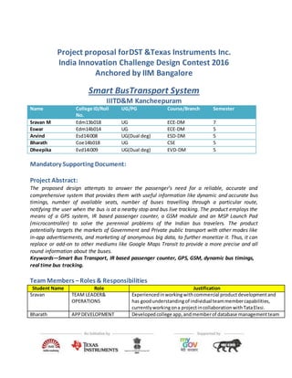
1. Project proposal forDST &Texas Instruments Inc.
India Innovation Challenge Design Contest 2016
Anchored by IIM Bangalore
Smart BusTransport System
IIITD&M Kancheepuram
Name College ID/Roll
No.
UG/PG Course/Branch Semester
Sravan M Edm13b018 UG ECE-DM 7
Eswar Edm14b014 UG ECE-DM 5
Arvind Esd14i008 UG(Dual deg) ESD-DM 5
Bharath Coe14b018 UG CSE 5
Dheepika Evd14i009 UG(Dual deg) EVD-DM 5
Mandatory Supporting Document:
Project Abstract:
The proposed design attempts to answer the passenger’s need for a reliable, accurate and
comprehensive system that provides them with useful information like dynamic and accurate bus
timings, number of available seats, number of buses travelling through a particular route,
notifying the user when the bus is at a nearby stop and bus live tracking. The product employs the
means of a GPS system, IR based passenger counter, a GSM module and an MSP Launch Pad
(microcontroller) to solve the perennial problems of the Indian bus travelers. The product
potentially targets the markets of Government and Private public transport with other modes like
in-app advertisements, and marketing of anonymous big data, to further monetize it. Thus, it can
replace or add-on to other mediums like Google Maps Transit to provide a more precise and all
round information about the buses.
Keywords—Smart Bus Transport, IR based passenger counter, GPS, GSM, dynamic bus timings,
real time bus tracking.
Team Members –Roles & Responsibilities
Student Name Role Justification
Sravan TEAM LEADER&
OPERATIONS
Experiencedinworkingwithcommercial productdevelopmentand
has goodunderstandingof individual teammembercapabilities,
currentlyworkingona projectincollaborationwithTataElxsi.
Bharath APPDEVELOPMENT Developedcollege app,and memberof database managementteam
2. for studentportal of IIITDM.
Arvind MARKETING Good understandingof publicmindsetandactive memberinpublicity
and sponsorshipteamof ourcollege.
Eswar TECHNICAL Have workedwiththe componentsbeingusedinthe project,
previouslyparticipatedinTIInnovationchallenge.
Dheepika TECHNICAL Good understandingof designandtechnical problemsinvolvedin
development.Participatedandhaswoninseveral technical
competiitons.
Market Analysis
A. Customer Need Identification :-
With the help of our classmates we formed 5 groups and collected data from around 300 bus
users in the following locations in Chennai: Thiruvanmiyur, Mount road, Tambaram, Redhills,
Perambur.
Here is the link for the sample template used for customer need analysis.
The following pie charts display the information gathered:
B. Serviceable Addressable Market (SAM) Identification & Justification :-
There are three potential markets for our service composition:
1.Governmentand private publictransport (buses):
Existing problemfaced by theseentities:
0
20
40
60
80
100
120
MIDDLE CLASS
EMPLOYES
LOWER MIDDLE
CLASS
EMPLOYES
IT
PROFFESIONALS
STUDENTS
App supporterssub-division
INTRESTED FOR SMART
TRANSPORT
% of Smart Phone users
YES(92.6)
NO(7.4)
% of App Supporters
YES(86.2)
NO(13.8)
3. a) Nowadays people are preferring mostly cabs in case of urgency, though low cost bus service is
available, due to uncertainty in the bus timings and seats.
b) In some bus routes there will be huge crowd and in some routes, there will be buses which will
travel almost empty i.e inefficient transport service
Proposed Solution (reasons for buying our product):
Users will tend to use bus services more if they are made more reliable by giving accurate bus
timings and seat availability prior to their journey.
Governmentandprivate busservices can pump in more buses in crowded places and reduce the
frequency in dry areas by using Big Data.
If Government or private bus services buys our entire product we can even provide e-ticketing
system.
2.AdvertisementProviders
Once the app is available online,variousfirmscanadvertise theirproductsbypayingthe requiredamount.
3. Big Data Clients(RestaurantOwners, ShoppingMall Owners,etc.)
Clientsrequireinformationlike
Identifyingthe crowdedregionsandnumberof peopletravellingthroughalocation.
PeakTime Periodof the place
Thisinformationcanbe usedbythe clientstosetupand improve theirfuture ventures.
C. Product Differentiation wrt. Competition&Justification: -
A formidable Competitor for our product is
Google MapsTransit(an online service): -
Thisprovidesthe availablebusdetails(busnumber,staticbustimings)if we input the source and
destinationplacesinsearchoption.But the maindifferences between the Google maps transit and
our product are:
we will provide exactlocationof the requiredbusincludingthe currentbusstopand next bus
stop in the bus route.
dynamic estimated time of arrival of busses (exact time to reach user’s nearest bus stop).
number of available seats in the bus.
notify when bus location is nearby 1km to source place (nearest bus stop to the user).
D. Understanding of yourcustomer &user: -
Customer:Governmentandprivate busentities,Advertisementproviders,BigDataclients.
User:General Public(buspassengers).
E. Distribution Channel Identification-
1. The hardware equipmentwill be installedinthe buses.
2. The app will be uploaded inplaystore andpassengerscaninstall itforfree.
3. Big data clients:The collectedanonymousinformationcanbe marketedtopotential clients
4. Proposed Design
A. Objective -
Customerneedanalysisconveysusthatmostof the passengerswantanaccurate transportation
systemwithlessuncertainty.Ourobjectiveistobuildasmart systemwhichgivesinformation(like
locationof bus,arrival time,seatavailability,numberof busesonroute) forthe userthrough
Mobile Application(App)usingGPS,IR,GSMModule,LaunchPad.
B. ProposedSolution
a. Block Diagram -
b. Diagramof Subsystems:
i ) Poweringcircuit:
ii )InfraredbasedPassengercounter:
5. The bus entrance has twotransmitters and receiverspairs placed horizontally on the opposite sides.
Whenthe passengerentersthe bus,the firstreceiversendssignal followedbythe secondreceiver
to the microcontroller (signal - high:low ~ low:high) and the count is increased by one as the
passenger enters.
Trigger sequence: 1>>>>2--------Passenger entered the bus.
Whenthe passengerleavesthe bus,the secondreceiversendssignal followedbythe firstreceiver
to the microcontroller (signal - low:high ~ high:low) and the count is decreased by one as the
passenger gets down the bus.
Trigger sequence: 2>>>>1--------Passenger got down the bus.
C. ComponentUsed-
TI Part Number How is it being used in the proposed solution? Explain
itsrole/functionality
Number of
components
MSP430FR6989
(Microcontroller)
To interface the CC4000, GSM (Sim900) module, Infrared based counter, by
receiving data from CC4000 and Infrared and sending the data through GSM
module to the server.(link)
1
BOOSTXL-
BATPAKMKII (Fuel
Tank Booster Pack)
To provide uninterruptedandrated power to the MSP430FR6989 (Launch Pad),
GPS, GSM module and IR based counter circuit without depending on the
existing bus battery. (link)
1
PMP9765 To charge the BOOSTXL- BATPAKMKII (Fuel Tank Booster Pack) when required
by providingconstant5V fromthe bus battery(source) andtoblockthe reverse
current flow from BOOSTXL- BATPAKMKII to bus battery. (link)
1
CC4000 (GPS
Module
To get informationaboutthe currentlocationof the bus(coordinates), velocity
at which the bus travels, and also the corresponding time. (link)
1
TLV2373 (Op Amp To amplify the voltage and current from the Infrared Receiver to feed the
MSP430FR6989 Launch pad. (link)
2
6. Non - TI Parts How is it being used in the proposed solution? Explain its role/functionality
GSM Module
(Sim 900)
To transmit data from the MSP430FR6989 (Launch pad) in the bus to the
Central Database (Server), which in turn to the Mobile App users.
Number of components required: 1
Detailedexplanationof the app interface: -
1
2
3
4 5
6
8
9
10
7
1. User Can Search the Bus He Needs TO
Board By typing The Bus Number Here
2. If User Forgot or Don’t Know the Bus
Number, He Can Search It by Typing
the Starting Point and Destination Point.
3. Here He User the Bus Numbers Which
Go Through the Given Starting Point
And Destination Points.
4. Red Markers Show the Various Bus
Locations Nearest To User.
5. Blue Marker Shows the User GPS
Location
LAYOUT-1
BUS NUMBERINFORMATION
LAYOUT-2
BUSES LOCATION
LAYOUT-3
BUS INFORMATION
6. Shows the No of Seats Available In
Selected Bus
7. Shows the Bus Current Departed
Bus Stop
8. Shows the Next Bus Stop
9. Shows the Expected Arrival Time
TO Ur Location or Nearest Bus
Stop….
10. By Clicking “SET AN ALARAM”
Button User Will Be Notified
Before 1Km of Bus Arrival to
his nearest bus stop location.
7. Innovativeness of the ProposedSolution
The conventional and highly popular google maps will give users with static bus timings
and its inability to provide information about seats is making users to prefer cabs due to
this unreliability. We can change this scenario with our product.
Impact of the proposedsolution
If our product is purchased by the government bus service, or if our product Is launched in
collaboration with it, we believe that it can significantly improve their revenue. Our product can
make the existing transport service more reliable in the minds of people, and also it can help in
improving the efficiency of the bus service by using
Feasibility