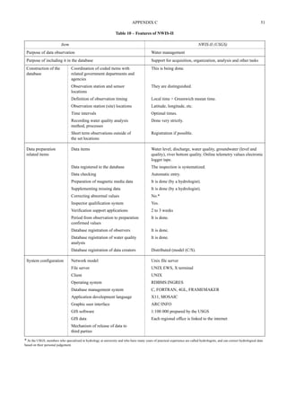
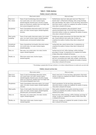
This document discusses hydrological databases and data management. It outlines the need for hydrological databases to store and disseminate observational data. Examples of existing national and international databases are provided. The typical configuration of a database includes data collection, input, storage, quality control, and dissemination through various methods. Guidance is given on constructing databases, including establishing coding systems, input formats, and procedures to address missing or poor quality data. Maintaining, updating, and managing databases over time is also discussed to respond to changing needs and technologies.


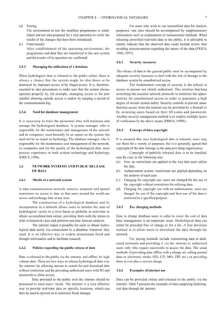
![14 HYDROLOGICAL DATA MANAGEMENT PRESENT STATE AND TRENDS
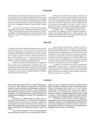
QUESTIONNAIRE II
QUESTIONNAIRE II SURVEY FIELD
Additional information was requested via a second questionnaire, sent in May 1999. Responses were collected from the following
countries: Australia, Brazil, New Zealand, Slovenia and the United States.
QUESTIONNAIRE II
We would like to ask your cooperation in answering the following questions regarding the hydrological data and database system, with
descriptions in English and selecting relevant answers with a cross [ ]. The hydrological data refer to those of climate, rainfail, runoff,
sediment, water quality, etc. If the question relates to material you consider confidential please write “Confidential” on the relevant item.
Section 1. Standardization of hydrological data
Q1.1 In the course of recording and processing data, two types of data, analog and digital data, are prepared. The analog data includes
manually recorded data, recording sheets of automatic recorders, etc., and the digital data are those recorded by electronic media
such as telemeter, data logger, etc. Regarding the analog and digital data, please answer the following.
(a) Which data are treated as official or formal?
[ ] analog data [ ] digital data [ ] depends on the kind of data
(b) If the last answer is selected, please specify.
Q1.2 In the case of international rivers which flow through more than two countries, it would be beneficial to share the hydrological
data mutually among the countries concerned. In this regard, please answer the following.
(a) Do you have international river(s)?
[ ] yes [ ] no
(b) If yes, is there any activity to standardize the hydrological database among the countries concerned?
[ ] yes [ ] no
(c) If yes, please give the following.
(i) Name of the international river.
(ii) Name of the organization for promoting standardization of the database.
(iii) Names of member countries of the organization.
Section 2. Hydrological database
Q2.1 Regarding the features of your hydrological database system, please answer the following.
(a) Name or type of database.
(b) Kinds of data handled.
(c) Time intervals of updating.
(d) Type and name of computer system (hardware).
(e) Operating system.
(f) Name of database application.
(g) Name of GIS application.
(h) Protocol of database network.
(i) Configuration (or system diagram) of database system. Please provide a copy.
Q2.2 Regarding the services of your database system, please answer the following.
(a) Are the real-time hydrological data offered to external clients?
[ ] yes with charge [ ] yes without charge [ ] no
(b) Are the historical data offered to external clients?
[ ] yes with charge [ ] yes without charge [ ] no
(c) If you charge for offering data, please describe the charging system or provide the tariff for reference.
Q2.3 Regarding the use of your data, please answer the following.
(a) Is the copyright reserved in your hydrological data?
[ ] yes [ ] no
(b) Are there any conditions or regulations to follow when using your data?
[ ] yes [ ] no
(c) If yes, please describe below.
(d) Please describe the general features of the database application used in your database system.](https://image.slidesharecdn.com/wmo-no964-140924044832-phpapp01/85/Hydrological-Data-Management-Present-State-and-Trends-Wmo-no964-24-320.jpg)
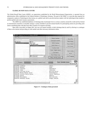
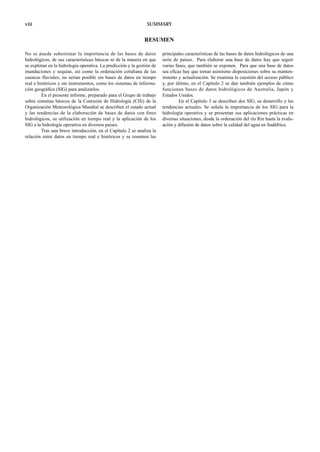
![APPENDIX A 15
Q2.4 Regarding the real-time hydrological data system, please answer the following.
(a) How do you adjust and/or correct for the lack of observation and abnormal records in your real-time hydrological data system?
(b) Do you have any established measures to adjust/correct real-time data automatically?
[ ] yes [ ] no
(c) If yes, please outline the system.
Q2.5 Regarding the quality control of hydrological data, please answer the following.
(a) Please outline your quality control system for hydrological data.
(b) Is any international standard such as ISO applied to the quality control of data?
[ ] yes [ ] no
(c) If yes, which standards (IS0 9002 for instance) are applied to which part of the quality control system?
Q2.6 Regarding the training of database-keeping staff and clients, please answer the following.
(a) Do you carry out training of database-keeping staff and clients?
[ ] yes for both the database-keeping staff and clients [ ] yes for database-keeping staff only
[ ] yes for clients only [ ] no
(b) If yes, please outline your training programme.
Q2.7 Regarding the network system for the hydrological database, please answer the following.
(a) Do you classify clients depending on the degree of accessibility (full or partial access) to the data?
[ ] yes [ ] no
(b) If yes, what are the criteria for classification?
(c) Do you have any regulation for regular change and control of the password to secure your database system?
[ ] yes [ ] no
(d) Do you separate data for public use from other data?
[ ] yes [ ] no
(e) If yes, what are the principles or criteria for the separation?
(f) Do you establish a separate database system for public use?
[ ] yes [ ] no
(g) What measures are you taking to protect the system from computer viruses and hackers?
(h) What is the backup system to secure the database from losses due to hardware crashing, earthquake, fire and other troubles?
Section 3. Application of GIS to hydrological database
Q3.1 Regarding the application of GIS to the hydrological database system, please answer the following.
(a) Do you have GIS linked to the hydrological database?
[ ] yes [ ] no
(b) If yes, is the GIS standardized, for example, in compliance with ISO or TC211?
[ ] yes [ ] no
(c) If yes, please describe the applied standards.
(d) Please outline the features of the GIS application you are using.
(e) If you establish GIS with the hydrological database, what advantages do you expect in hydrological data management in practice?](https://image.slidesharecdn.com/wmo-no964-140924044832-phpapp01/85/Hydrological-Data-Management-Present-State-and-Trends-Wmo-no964-25-320.jpg)
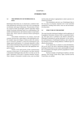
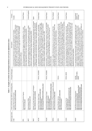
![28 HYDROLOGICAL DATA MANAGEMENT PRESENT STATE AND TRENDS
ANSWERS TO QUESTIONNAIRE II
AUSTRALIA
Please note where possible the answers to the questions cover the meteorological data collection by the national meteorological organization
and the hydrometeorological data collection by the eight main state government water agencies.
Section 1. Standardization of hydrological data
Q1.1 In the course of recording and processing data, two types of data, analog and digital data, are prepared. The analog data includes
manually recorded data, recording sheets of automatic recorders, etc., and the digital data are those recorded by electronic media
such as telemeter, data logger, etc. Regarding the analog and digital data, please answer the following.
(a) Which data are treated as official or formal?
[ ] analog data [ ] digital data [x] depends on the kind of data
(b) If the last answer is selected, please specify.
From some stations digital data is received for real-time operational purposes. The analog data is received later and after
quality control may replace the digital data in the data archive.
Q1.2 In the case of international rivers which flow through more than two countries, it would be beneficial to share the hydrological
data mutually among the countries concerned. In this regard, please answer the following.
(a) Do you have international river(s)?
[ ] yes [x] no
(b) If yes, is there any activity to standardize the hydrological database among the countries concerned?
[ ] yes [ ] no
(c) If yes, please give the following.
(i) Name of the international river.
(ii) Name of the organization for promoting standardization of the database.
(iii) Names of member countries of the organization.
Section 2. Hydrological database
Q2.1 Regarding the features of your hydrological database system, please answer the following.
(a) Name or type of database.
Meteorology: Oracle
Hydrology: most agencies use a proprietry package called HYDSYS
(b) Kinds of data handled.
Meteorology: all meteorological variables
Hydrology: rainfall, surface water data, groundwater data and water quality data
(c) Time intervals of updating.
Meteorology: regular and ongoing
Hydrology: regular and ongoing
(d) Type and name of computer system (hardware).
Meteorology: HP 9000 Series 800 servers
Hydrology: Intel based desktop computers
(e) Operating system.
Meteorology: HP Unix
Hydrology: MS Windows
(f) Name of database application.
Meteorology: Oracle
Hydrology: proprietry system using DB III files
(g) Name of GIS application.
Meteorology: no GIS linked to the database system but ArcInfo and ArcView are used.
Hydrology: simple proprietry mapping package in the database system. ArcInfo, ArcView and MapInfo are also used to display
data and network information
(h) Protocol of database network.
Meteorology: TCP/IP and SQL
Hydrology: Windows networking and proprietry HYDSYS file and record control management
(i) Configuration (or system diagram) of database system. Please provide a copy.
Too large and complex to provide.
Q2.2 Regarding the services of your database system, please answer the following.
(a) Are the real-time hydrological data offered to external clients?
[ ] yes with charge [ ] yes without charge [ ] no
Yes, but arrangements and possible charges vary between organizations.](https://image.slidesharecdn.com/wmo-no964-140924044832-phpapp01/85/Hydrological-Data-Management-Present-State-and-Trends-Wmo-no964-38-320.jpg)
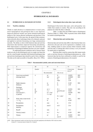
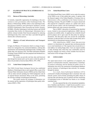
![(b) Are the historical data offered to external clients?
[x] yes with charge [x] yes without charge [ ] no
Depends on the different agencies and the use of the data.
(c) If you charge for offering data, please describe the charging system or provide the tariff for reference.
If a charge is applied then it is usually just to cover the cost of extracting and preparing the data in the format required.
Charging rates vary between agencies providing the data.
Q2.3 Regarding the use of your data, please answer the following.
(a) Is the copyright reserved in your hydrological data?
[x] yes [ ] no
(b) Are there any conditions or regulations to follow when using your data?
[x] yes [ ] no
(c) If yes, please describe below.
Data are not to be sold or passed on to a third party without permission of the copyright holder.
(d) Please describe the general features of the database application used in your database system.
• Extracts data;
• Range of standard analyses: hourly totals, daily totals, monthly totals;
• Storm events, annual series, distribution fitting, flow duration;
• Statistical summaries, intensity frequency duration, double mass curves;
• Range of presentations: tabulations, graphs;
• Export of data in a range of formats.
Q2.4 Regarding the real-time hydrological data system, please answer the following.
(a) How do you adjust and/or correct for the lack of observation and abnormal records in your real-time hydrological data system?
Manual intervention
(b) Do you have any established measures to adjust/correct real-time data automatically?
[x] yes [ ] no
(c) If yes, please outline the system.
Simple bounds checking and rate of change checks to highlight possible values in error.
Q2.5 Regarding the quality control of hydrological data, please answer the following.
(a) Please outline your quality control system for hydrological data.
• Varies between the agencies but will often include some or all of the following:
• Check against neighbouring station;
• Use of long-term check gauges to verify TBRG operation;
• Double mass curves;
• Reasonable value checks based on long term station statisties;
• Volume balance between neighbouring flow stations;
• Visual inspection of plotted data.
(b) Is any international standard such as ISO applied to the quality control of data?
[x] yes [ ] no
Some State water agencies have ISO certification for their data management others do not. The national meteorological agency
does not apply ISO standards.
(c) If yes, which standards (IS0 9002 for instance) are applied to which part of the quality control system?
Information is not available.
Q2.6 Regarding the training of database-keeping staff and clients, please answer the following.
(a) Do you carry out training of database-keeping staff and clients?
[ ] yes for both the database-keeping staff and clients [x] yes for database-keeping staff only
[ ] yes for clients only [ ] no
(b) If yes, please outline your training programme.
Varies between agencies but consists of:
• In-house training;
• External course provided by educational institutions;
• Courses provided by the database developers and software suppliers.
Q2.7 Regarding the network system for the hydrological database, please answer the following.
(a) Do you classify clients depending on the degree of accessibility (full or partial access) to the data?
[x] yes [ ] no
(b) If yes, what are the criteria for classification?
External clients do not have direct access to the database.
Internal users are classified depending on their need to read, update or create data files.
(c) Do you have any regulation for regular change and control of the password to secure your database system?
[x] yes [ ] no
APPENDIX A 29](https://image.slidesharecdn.com/wmo-no964-140924044832-phpapp01/85/Hydrological-Data-Management-Present-State-and-Trends-Wmo-no964-39-320.jpg)
![30 HYDROLOGICAL DATA MANAGEMENT PRESENT STATE AND TRENDS
(d) Do you separate data for public use from other data?
[x] yes [ ] no
(e) If yes, what are the principles or criteria for the separation?
Some water agencies collect data for commercial operations or for use in operational water supply management. This data may
be confidential and may not be made available to the public.
(f) Do you establish a separate database system for public use?
[ ] yes [x] no
But data products may be generated from the main database system made available to the public, e.g. by the internet.
(g) What measures are you taking to protect the system from computer viruses and hackers?
Firewalls to exclude external access, regular backups and regular software checks.
(h) What is the backup system to secure the database from losses due to hardware crashing, earthquake, fire and other troubles?
This will vary from agency to agency but will generally consist of:
• Backup to tape and CD;
• Some organizations hold hold backups at another secure location;
• Some organizations run duplicate databases.
Section 3. Application of GIS to hydrological database
Q3.1 Regarding the application of GIS to the hydrological database system, please answer the following.
(a) Do you have GIS linked to the hydrological database?
[ ] yes [x] no
But GIS systems are used to display data and network information extracted from the databases.
(b) If yes, is the GIS standardized, for example, in compliance with ISO or TC211?
[x] yes [ ] no
(c) If yes, please describe the applied standards.
Standard GIS packages are used such as ArcInfo, ArcView and MapInfo. So the standards applied are whatever standards are
built into them.
(d) Please outline the features of the GIS application you are using.
• Standard mapping and spatial presentation features;
• Rainfall and runoff analyses such as isohyetal type analyses or polygon analyses.
(e) If you establish GIS with the hydrological database, what advantages do you expect in hydrological data management in practice?
• Network design;
• Presentation and analysis of data for quality control purposes;
• Improved and more rapid presentation of data;
• Presentation of real-time data.](https://image.slidesharecdn.com/wmo-no964-140924044832-phpapp01/85/Hydrological-Data-Management-Present-State-and-Trends-Wmo-no964-40-320.jpg)
![BRAZIL
Section 1. Standardization of hydrological data
Q1.1 In the course of recording and processing data, two types of data, analog and digital data, are prepared. The analog data includes
manually recorded data, recording sheets of automatic recorders, etc., and the digital data are those recorded by electronic media
such as telemeter, data logger, etc. Regarding the analog and digital data, please answer the following.
(a) Which data are treated as official or formal?
[x] analog data [x] digital data [ ] depends on the kind of data
(b) If the last answer is selected, please specify.
Q1.2 In the case of international rivers which flow through more than two countries, it would be beneficial to share the hydrological
data mutually among the countries concerned. In this regard, please answer the following.
(a) Do you have international river(s)?
[x] yes [ ] no
(b) If yes, is there any activity to standardize the hydrological database among the countries concerned?
[x] yes [ ] no
(c) If yes, please give the following.
(i) Name of the international river.
Prata (Paraná) River and some of its tributaries.
(ii) Name of the organization for promoting standardization of the database.
Comite Internacional de Cooperação (CIC).
(iii) Names of member countries of the organization.
Argentina, Brazil, Bolivia, Paraguay and Uruguay.
Section 2. Hydrological database
Q2.1 Regarding the features of your hydrological database system, please answer the following.
(a) Name or type of database.
SQL server
(b) Kinds of data handled.
Level, discharge, rain, water quality and sediment
(c) Time intervals of updating.
Approximately three months
(d) Type and name of computer system (hardware).
ALR – Intel Pentium II dual processors
(e) Operating system.
Windows NT server
(f) Name of database application.
Hidro-1.0
(g) Name of GIS application.
ArcView
(h) Protocol of database network.
TCP/IP
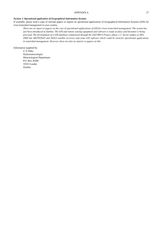
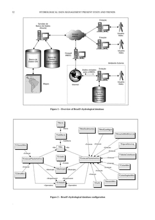
(i) Configuration (or system diagram) of database system. Please provide a copy.
Q2.2 Regarding the services of your database system, please answer the following.
(a) Are the real-time hydrological data offered to external clients?
[x] yes with charge [ ] yes without charge [ ] no
(b) Are the historical data offered to external clients?
[ ] yes with charge [x] yes without charge [ ] no
(c) If you charge for offering data, please describe the charging system or provide the tariff for reference.
Q2.3 Regarding the use of your data, please answer the following.
(a) Is the copyright reserved in your hydrological data?
[x] yes [ ] no
(b) Are there any conditions or regulations to follow when using your data?
[x] yes [ ] no
(c) If yes, please describe below.
(d) Please describe the general features of the database application used in your database system.
Georeferenced hydrometerological data, consist data, cross link regular data and geographical data, tabular input and output,
statistical data.
Q2.4 Regarding the real-time hydrological data system, please answer the following.
(a) How do you adjust and/or correct for the lack of observation and abnormal records in your real-time hydrological data system?
Through comparison graphics.
APPENDIX A 31](https://image.slidesharecdn.com/wmo-no964-140924044832-phpapp01/85/Hydrological-Data-Management-Present-State-and-Trends-Wmo-no964-41-320.jpg)
![APPENDIX A 33
(b) Do you have any established measures to adjust/correct real-time data automatically?
[x] yes [ ] no
(c) If yes, please outline the system.
Q2.5 Regarding the quality control of hydrological data, please answer the following.
(a) Please outline your quality control system for hydrological data.
Historical data quality is being analysed.
(b) Is any international standard such as ISO applied to the quality control of data?
[x] yes [ ] no
(c) If yes, which standards (IS0 9002 for instance) are applied to which part of the quality control system?
In implementation.
Q2.6 Regarding the training of database-keeping staff and clients, please answer the following.
(a) Do you carry out training of database-keeping staff and clients?
[ ] yes for both the database-keeping staff and clients [x] yes for database-keeping staff only
[ ] yes for clients only [ ] no
(b) If yes, please outline your training programme.
Q2.7 Regarding the network system for the hydrological database, please answer the following.
(a) Do you classify clients depending on the degree of accessibility (full or partial access) to the data?
[x] yes [ ] no
(b) If yes, what are the criteria for classification?
Government bodies have free access to the database.
(c) Do you have any regulation for regular change and control of the password to secure your database system?
[ ] yes [x] no
(d) Do you separate data for public use from other data?
[x] yes [ ] no
(e) If yes, what are the principles or criteria for the separation?
Government bodies have free access to the database.
(f) Do you establish a separate database system for public use?
[ ] yes [x] no
(g) What measures are you taking to protect the system from computer viruses and hackers?
Firewall, proxy server and virus protection software.
(h) What is the backup system to secure the database from losses due to hardware crashing, earthquake, fire and other troubles?
Backup on CD-ROM, DAT tape and use of a safe room.
Section 3. Application of GIS to hydrological database
Q3.1 Regarding the application of GIS to the hydrological database system, please answer the following.
(a) Do you have GIS linked to the hydrological database?
[x] yes [ ] no
(b) If yes, is the GIS standardized, for example, in compliance with ISO or TC211?
[x] yes [ ] no
(c) If yes, please describe the applied standards.
ArcView
(d) Please outline the features of the GIS application you are using.
Spatial analysis, river analysis
(e) If you establish GIS with the hydrological database, what advantages do you expect in hydrological data management in practice?
Publish online data on internet and other media.](https://image.slidesharecdn.com/wmo-no964-140924044832-phpapp01/85/Hydrological-Data-Management-Present-State-and-Trends-Wmo-no964-43-320.jpg)
![34 HYDROLOGICAL DATA MANAGEMENT PRESENT STATE AND TRENDS
NEW ZEALAND
Section 1. Standardization of hydrological data
Q1.1 In the course of recording and processing data, two types of data, analog and digital data, are prepared. The analog data includes
manually recorded data, recording sheets of automatic recorders, etc., and the digital data are those recorded by electronic media
such as telemeter, data logger, etc. Regarding the analog and digital data, please answer the following.
(a) Which data are treated as official or formal?
[ ] analog data [x] digital data [ ] depends on the kind of data
(b) If the last answer is selected, please specify.
Q1.2 In the case of international rivers which flow through more than two countries, it would be beneficial to share the hydrological
data mutually among the countries concerned. In this regard, please answer the following.
(a) Do you have international river(s)?
[ ] yes [x] no
(b) If yes, is there any activity to standardize the hydrological database among the countries concerned?
[ ] yes [ ] no
(c) If yes, please give the following.
(i) Name of the international river.
(ii) Name of the organization for promoting standardization of the database.
(iii) Names of member countries of the organization.
Section 2. Hydrological database
Q2.1 Regarding the features of your hydrological database system, please answer the following.
(a) Name or type of database.
“Tideda”
(b) Kinds of data handled.
Water levels (groundwater, lake, river, estuary, sea), discharges, sediment concentrations, rainfall.
(c) Time intervals of updating.
Various, but usually three-monthly. Some data are updated to the (raw) datbases in real-time (every 15 minutes or one hour).
(d) Type and name of computer system (hardware).
Dell Pentium Optiplex GX1 PII 350, 64 Mhz, memegory, 9 Gb
(e) Operating system.
Windows NT
(f) Name of database application.
“Tideda”
(g) Name of GIS application.
ArcView
(h) Protocol of database network.
TCP/IP
(i) Configuration (or system diagram) of database system. Please provide a copy.
Not available
Q2.2 Regarding the services of your database system, please answer the following.
(a) Are the real-time hydrological data offered to external clients?
[x] yes with charge [ ] yes without charge [ ] no
(b) Are the historical data offered to external clients?
[x] yes with charge [ ] yes without charge [ ] no
(c) If you charge for offering data, please describe the charging system or provide the tariff for reference.
Charging for historical data is only for the time taken for the database operator to copy the data onto a file and send it to the
client by either internet or by copying the file to a diskette or CD-ROM and posting it to the client. For real-time data, clients
usually bave a contract whereby they pay for the whole package of the costs for the time associated with collection and trans-mission
of the data to their offices.
Q2.3 Regarding the use of your data, please answer the following.
(a) Is the copyright reserved in your hydrological data?
[x] yes [ ] no
(b) Are there any conditions or regulations to follow when using your data?
[x] yes [ ] no
(c) If yes, please describe below.
Data funded by commercial operators are owned by those agencies and their permission must be obtained by a third party
wishing to use the data.
Data funded by the New Zealand Government are owned by the New Zealand Government and are freely available for the good
of all. Acknowledgement of this is is often required when using the data for commercial and scientific purposes.](https://image.slidesharecdn.com/wmo-no964-140924044832-phpapp01/85/Hydrological-Data-Management-Present-State-and-Trends-Wmo-no964-44-320.jpg)
![APPENDIX A 35
(d) Please describe the general features of the database application used in your database system.
Data are transferred by radio to local field offices, and then by internet automatically to the central raw hydrological database.
These data are disseminated to real-time users. After quality assurance procedures carried out at the central and local offices,
the data are transferred to a confirmed hydrological database.
Q2.4 Regarding the real-time hydrological data system, please answer the following.
(a) How do you adjust and/or correct for the lack of observation and abnormal records in your real-time hydrological data system?
A gap is left as a gap, unless a client specifically wishes for it to be detected and corrected. This is done manually by correlation
with neighbouring stations. Some research has been done here on automating this using neural network procedures.
(b) Do you have any established measures to adjust/correct real-time data automatically?
[ ] yes [x] no
(c) If yes, please outline the system.
But we are working towards this using neural networks.
Q2.5 Regarding the quality control of hydrological data, please answer the following.
(a) Please outline your quality control system for hydrological data.
This will be too long. I will send you a separate document about this. You can also read about our QA system in a paper in the
Hydrological Sciences Journal in 1987 by Mosley and McKerchar.
(b) Is any international standard such as ISO applied to the quality control of data?
[x] yes [ ] no
(c) If yes, which standards (IS0 9002 for instance) are applied to which part of the quality control system?
IS0 9002 to the whole system.
Q2.6 Regarding the training of database-keeping staff and clients, please answer the following.
(a) Do you carry out training of database-keeping staff and clients?
[x] yes for both the database-keeping staff and clients [ ] yes for database-keeping staff only
[ ] yes for clients only [ ] no
(b) If yes, please outline your training programme.
Occasional courses and in-house training programmes.
Q2.7 Regarding the network system for the hydrological database, please answer the following.
(a) Do you classify clients depending on the degree of accessibility (full or partial access) to the data?
[ ] yes [x] no
(b) If yes, what are the criteria for classification?
(c) Do you have any regulation for regular change and control of the password to secure your database system?
[x] yes [ ] no
(d) Do you separate data for public use from other data?
[x] yes [ ] no
(e) If yes, what are the principles or criteria for the separation?
Based on data ownership – private versus government.
(f) Do you establish a separate database system for public use?
[x] yes [ ] no
Planned for WWW access only. Otherwise we provide the data.
(g) What measures are you taking to protect the system from computer viruses and hackers?
We have firewalls established by our IT group.
(h) What is the backup system to secure the database from losses due to hardware crashing, earthquake, fire and other troubles?
Regular backups are made. Data are stored in different buildings also.
Section 3. Application of GIS to hydrological database
Q3.1 Regarding the application of GIS to the hydrological database system, please answer the following.
(a) Do you have GIS linked to the hydrological database?
[x] yes [ ] no
(b) If yes, is the GIS standardized, for example, in compliance with ISO or TC211?
[x] yes [ ] no
(c) If yes, please describe the applied standards.
ArcView and ArcInfo
(d) Please outline the features of the GIS application you are using.
ArcView and ArcInfo
(e) If you establish GIS with the hydrological database, what advantages do you expect in hydrological data management in practice?
Easier to visualize location of monitoring stations and to make network decisions.](https://image.slidesharecdn.com/wmo-no964-140924044832-phpapp01/85/Hydrological-Data-Management-Present-State-and-Trends-Wmo-no964-45-320.jpg)
![36 HYDROLOGICAL DATA MANAGEMENT PRESENT STATE AND TRENDS
SLOVENIA
Section 1. Standardization of hydrological data
Q1.1 In the course of recording and processing data, two types of data, analog and digital data, are prepared. The analog data includes
manually recorded data, recording sheets of automatic recorders, etc., and the digital data are those recorded by electronic media
such as telemeter, data logger, etc. Regarding the analog and digital data, please answer the following.
(a) Which data are treated as official or formal?
[x] analog data [ ] digital data [ ] depends on the kind of data
(b) If the last answer is selected, please specify.
Q1.2 In the case of international rivers which flow through more than two countries, it would be beneficial to share the hydrological
data mutually among the countries concerned. In this regard, please answer the following.
(a) Do you have international river(s)?
[x] yes [ ] no
(b) If yes, is there any activity to standardize the hydrological database among the countries concerned?
[x] yes [ ] no
(c) If yes, please give the following.
(i) Name of the international river.
The Soèa in the Adriatic basin and the Sava, Drava and Mura rivers in the Danube basin.
(ii) Name of the organization for promoting standardization of the database.
NEDHYCOS, Danube Commission
(iii) Names of member countries of the organization.
Mediterranean countries and the Danube basin countries.
Section 2. Hydrological database
Q2.1 Regarding the features of your hydrological database system, please answer the following.
(a) Name or type of database.
INDEX FILES
(b) Kinds of data handled.
Hourly data (water levels), daily data (water levels, discharges, water temperatures, concentrations of suspended material,
quantities of transported material), rating curves, hydrometric measurements, inventory of gauging stations
(c) Time intervals of updating.
12 months (official – controlled data)
(d) Type and name of computer system (hardware).
MicroVAX 3100 - 80
(e) Operating system.
Open VMS VAX V5.5-1
(f) Name of database application.
Hydrological Data Bank (BHP)
(g) Name of GIS application.
(h) Protocol of database network.
(i) Configuration (or system diagram) of database system. Please provide a copy.
Attached
Q2.2 Regarding the services of your database system, please answer the following.
(a) Are the real-time hydrological data offered to external clients?
[ ] yes with charge [x] yes without charge [ ] no
(b) Are the historical data offered to external clients?
[ ] yes with charge [x] yes without charge [ ] no
(c) If you charge for offering data, please describe the charging system or provide the tariff for reference.
Although “without charge”, the HMZ charges data users for the staff time used for carrying out services and for the costs of
materials, handling and mailing.
Q2.3 Regarding the use of your data, please answer the following.
(a) Is the copyright reserved in your hydrological data?
[x] yes [ ] no
(b) Are there any conditions or regulations to follow when using your data?
[x] yes [ ] no
(c) If yes, please describe below.
According to the policy guidelines for the dissemination of data and costing of services (GRDC — Global Runoff Data Centre,
Federal Institute of Hydrology, Koblenz, Germany).
(d) Please describe the general features of the database application used in your database system.
H–Q transformations; monthly and yearly tables, graphics; statistical analyses of time series.](https://image.slidesharecdn.com/wmo-no964-140924044832-phpapp01/85/Hydrological-Data-Management-Present-State-and-Trends-Wmo-no964-46-320.jpg)
![APPENDIX A 37
Q2.4 Regarding the real-time hydrological data system, please answer the following.
(a) How do you adjust and/or correct for the lack of observation and abnormal records in your real-time hydrological data system?
We do not! We use only logical controls of data.
(b) Do you have any established measures to adjust/correct real-time data automatically?
[ ] yes [x] no
(c) If yes, please outline the system.
Q2.5 Regarding the quality control of hydrological data, please answer the following.
(a) Please outline your quality control system for hydrological data.
Water balance, correlation to the neighbouring gauging station.
(b) Is any international standard such as ISO applied to the quality control of data?
[ ] yes [x] no (WMO recommendations)
(c) If yes, which standards (IS0 9002 for instance) are applied to which part of the quality control system?
Q2.6 Regarding the training of database-keeping staff and clients, please answer the following.
(a) Do you carry out training of database-keeping staff and clients?
[ ] yes for both the database-keeping staff and clients [ ] yes for database-keeping staff only
[ ] yes for clients only [x] no
(b) If yes, please outline your training programme.
Q2.7 Regarding the network system for the hydrological database, please answer the following.
BHP is not connected to the network system!
(a) Do you classify clients depending on the degree of accessibility (full or partial access) to the data?
[ ] yes [x] no
(b) If yes, what are the criteria for classification?
(c) Do you have any regulation for regular change and control of the password to secure your database system?
[ ] yes [x] no
(d) Do you separate data for public use from other data?
[ ] yes [x] no
(e) If yes, what are the principles or criteria for the separation?
(f) Do you establish a separate database system for public use?
[ ] yes [x] no
(g) What measures are you taking to protect the system from computer viruses and hackers?
(h) What is the backup system to secure the database from losses due to hardware crashing, earthquake, fire and other troubles?
We use OPEN WMS – backup utility and we keep three copies of the database on different media and in different locations.
Section 3. Application of GIS to hydrological database
Q3.1 Regarding the application of GIS to the hydrological database system, please answer the following.
(a) Do you have GIS linked to the hydrological database?
[ ] yes [x] no
(b) If yes, is the GIS standardized, for example, in compliance with ISO or TC211?
[ ] yes [x] no
(c) If yes, please describe the applied standards.
(d) Please outline the features of the GIS application you are using.
(e) If you establish GIS with the hydrological database, what advantages do you expect in hydrological data management in practice?
At this moment we run two separate systems:
• controlled, official data (in databank);
• real-time data which are used in prognostic services (flood forecasting and warning system) and are disseminated to the public
through the internet and TV. In exceptional cases real-time data could be used to fill gaps in the analog data series. As a rule,
real-time data are not offered to external clients.](https://image.slidesharecdn.com/wmo-no964-140924044832-phpapp01/85/Hydrological-Data-Management-Present-State-and-Trends-Wmo-no964-47-320.jpg)
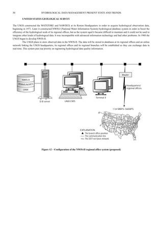
![APPENDIX A 39
UNITED STATES
Section 1. Standardization of hydrological data
Q1.1 In the course of recording and processing data, two types of data, analog and digital data, are prepared. The analog data includes
manually recorded data, recording sheets of automatic recorders, etc., and the digital data are those recorded by electronic media
such as telemeter, data logger, etc. Regarding the analog and digital data, please answer the following.
(a) Which data are treated as official or formal?
[x] analog data [x] digital data [ ] depends on the kind of data
(b) If the last answer is selected, please specify.
Both analog and digital data are official. All field notes and digital films are archived.
Q1.2 In the case of international rivers which flow through more than two countries, it would be beneficial to share the hydrological
data mutually among the countries concerned. In this regard, please answer the following.
(a) Do you have international river(s)?
[x] yes [ ] no
(b) If yes, is there any activity to standardize the hydrological database among the countries concerned?
[x] yes [ ] no
(c) If yes, please give the following.
(i) Name of the international river.
Many rivers between the US, Canada and Mexico.
(ii) Name of the organization for promoting standardization of the database.
International Joint Commission (US, Canada)
(iii) Names of member countries of the organization.
Section 2. Hydrological database
Q2.1 Regarding the features of your hydrological database system, please answer the following.
(a) Name or type of database.
National Water Information System (NWIS)
(b) Kinds of data handled.
River stage, river discharge, precipitation, groundwater levels, water chemistry, suspended sediment, biology
(c) Time intervals of updating.
15 minutes, daily and periodic
(d) Type and name of computer system (hardware).
Data General and Sun servers
Personal computer desktops (many brands)
(e) Operating system.
DG and Sun mix
(f) Name of database application.
Ingres
(g) Name of GIS application.
ESRI, ArcInfo
(h) Protocol of database network.
Operational database distributed on 46 servers nationwide
(i) Configuration (or system diagram) of database system. Please provide a copy.
Q2.2 Regarding the services of your database system, please answer the following.
(a) Are the real-time hydrological data offered to external clients?
[ ] yes with charge [x] yes without charge [ ] no
(b) Are the historical data offered to external clients?
[ ] yes with charge [x] yes without charge [ ] no
(c) If you charge for offering data, please describe the charging system or provide the tariff for reference.
Q2.3 Regarding the use of your data, please answer the following.
(a) Is the copyright reserved in your hydrological data?
[ ] yes [x] no
(b) Are there any conditions or regulations to follow when using your data?
[ ] yes [x] no
(c) If yes, please describe below.
(d) Please describe the general features of the database application used in your database system.
The NWIS database is an internal system for day-to-day processing. Public access of real-time and historical data is via the
internet.
Q2.4 Regarding the real-time hydrological data system, please answer the following.](https://image.slidesharecdn.com/wmo-no964-140924044832-phpapp01/85/Hydrological-Data-Management-Present-State-and-Trends-Wmo-no964-49-320.jpg)
![40 HYDROLOGICAL DATA MANAGEMENT PRESENT STATE AND TRENDS
(a) How do you adjust and/or correct for the lack of observation and abnormal records in your real-time hydrological data system?
We do not estimate missing data real-time. We use various thresholds to check for anomalies.
(b) Do you have any established measures to adjust/correct real-time data automatically?
[ ] yes [x] no
(c) If yes, please outline the system.
Q2.5 Regarding the quality control of hydrological data, please answer the following.
(a) Please outline your quality control system for hydrological data.
All data are checked and reviewed at the state office. A subset of data are reviewed every three years at the national level.
(b) Is any international standard such as ISO applied to the quality control of data?
[ ] yes [x] no
(c) If yes, which standards (IS0 9002 for instance) are applied to which part of the quality control system?
Q2.6 Regarding the training of database-keeping staff and clients, please answer the following.
(a) Do you carry out training of database-keeping staff and clients?
[ ] yes for both the database-keeping staff and clients [x] yes for database-keeping staff only
[ ] yes for clients only [ ] no
Some informal training for major clients.
(b) If yes, please outline your training programme.
Training courses programme is offered periodically at the regional and national level, usually when the software is upgraded.
Q2.7 Regarding the network system for the hydrological database, please answer the following.
(a) Do you classify clients depending on the degree of accessibility (full or partial access) to the data?
[ ] yes [x] no
All clients have equal access through the internet.
(b) If yes, what are the criteria for classification?
(c) Do you have any regulation for regular change and control of the password to secure your database system?
[x] yes [ ] no
(d) Do you separate data for public use from other data?
[x] yes [ ] no
(e) If yes, what are the principles or criteria for the separation?
Public access is through the internet.
(f) Do you establish a separate database system for public use?
[x] yes [ ] no
(g) What measures are you taking to protect the system from computer viruses and hackers?
(h) What is the backup system to secure the database from losses due to hardware crashing, earthquake, fire and other troubles?
Daily backups, weekly and monthly backup tapes secured offsite. We are in the process of installing redundancies, servers for
processing and survey data.
Section 3. Application of GIS to hydrological database
Q3.1 Regarding the application of GIS to the hydrological database system, please answer the following.
(a) Do you have GIS linked to the hydrological database?
[ ] yes [x] no
(b) If yes, is the GIS standardized, for example, in compliance with ISO or TC211?
[ ] yes [ ] no
(c) If yes, please describe the applied standards.
(d) Please outline the features of the GIS application you are using.
(e) If you establish GIS with the hydrological database, what advantages do you expect in hydrological data management in practice?](https://image.slidesharecdn.com/wmo-no964-140924044832-phpapp01/85/Hydrological-Data-Management-Present-State-and-Trends-Wmo-no964-50-320.jpg)

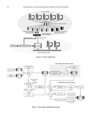
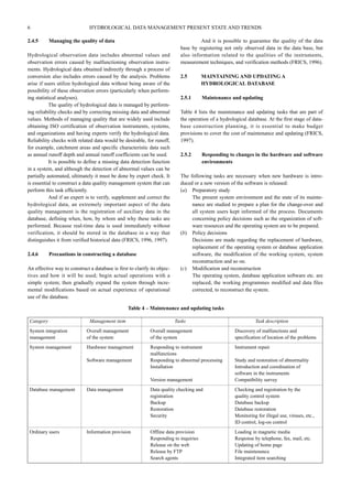
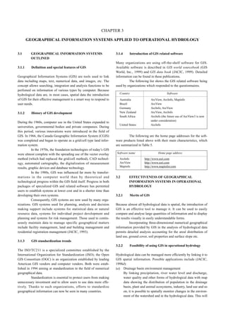
![46 HYDROLOGICAL DATA MANAGEMENT PRESENT STATE AND TRENDS
1) Basic specifications
Table 9 – Database entry format
• Text shall be ASCII code;
• It must be possible to enter and output data with spreadsheet software;
• The format must have high extensibility and flexibility.
2) File specifications
• The file specifications: DOS standard text file;
• The text code: half size text ASCII;
• Extension: wsf.
3) Data specifications
• Date, time: western calendar years: month, day, hour, minute;
• Water level: recorded as values in metre units based on the reference elevation (zero level);
• Precipitation: recorded in mm;
• Discharge: recorded in m3/s.
4) Basic configuration
The observation station category, data quality information etc. are registered as station text while the observation values are registered as
data text. Hydrological data is registered by a repetitive station text + data text registration process.
FILE, EOF and OED text are fixed form data attached to the beginning and end of each datum.
Header Description
FILE Only one is recorded at the beginning of the file. It corresponds to EOF.
EOF Only one is recorded at the end of the file. Lines coming after EOF are invalid.
COM Comment line. It can be recorded on all lines within a file. It has no effect ory processing.
STATION Station: enter in the sequence:
[1] observation station category.
[2] database registration code.
[3] quality code.
[4] sensor code.
Following station: enter the following codes and values (they are effective until the next station):
[1] observation station category – water level/discharge observation station: (H), precipitation observation station: (R),
water quality observation station: (WQ), groundwater level observation station: (GH), groundwater quality observation station:
(GWQ), dam: (DAM), intake volume: (PUMP), meteorological observation station: (MET), oceanographic
phenomena: (OCE).
[2] Database registration code.
[3] Quality code – original: (1), sensor corrected: (2), AQC complete: (3), verified: (4), publication approved: (5).
[4] Sensor code – telemeter (1), electronic logger: (2), self-recorder: (3), normal: (4), other (5).
DATA Data set name
Lines following the data line and preceding the OED line are data recording lines. (Input in the sequence: year, month, day,
hour, minute, observed value.
EOD Recorded on the line following the final data recording line.](https://image.slidesharecdn.com/wmo-no964-140924044832-phpapp01/85/Hydrological-Data-Management-Present-State-and-Trends-Wmo-no964-56-320.jpg)