The document discusses an indoor navigation system that uses WiFi positioning to determine a user's location inside a building and provide routing directions. It covers several key aspects:
1. An overview of various indoor positioning technologies including GPS, cellular, infrared, UWB, Bluetooth, and WiFi. WiFi is identified as the preferred approach due to widespread availability and low cost.
2. Details on how WiFi positioning works, including techniques like triangulation, fingerprinting, and considerations of RSSI, MAC addresses, and network details.
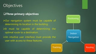
3. The system's objectives of indoor positioning, routing, and tracking. It also outlines implementation in models like universities and shopping malls.
4. Additional technical components
Determining a person’s physical position in a multi-building indoor space using wifi fingerprinting on UJIIndoor Data Set to construct machine learning models.
Free Space Optics (FSO) communications, also called Free Space Photonics (FSP) or Optical Wireless, refers to the transmission of modulated visible or infrared (IR) beams through the atmosphere to obtain optical communications. Like fiber, Free Space Optics (FSO) uses lasers to transmit data, but instead of enclosing the data stream in a glass fiber, it is transmitted through the air. Free Space Optics (FSO) works on the same basic principle as Infrared television remote controls, wireless keyboards
This is used to track the exact location of a vehicle using GPS tracking systems and give information about the position to concerned person through GSM via SMS.
In today’s world energy saving has become a major factor and need. This project is developed keeping this problem in mind. The huge amount of electrical power of many countries is consumed in lighting the streets. However, there are stages of time when there is less vehicle density during night time or even no vehicles during late night time. The main principle of this system is object detection and then triggering the respective circuit and to provide light only at that part of road where it is needed. Logically, this system may save a large amount of the electrical power. This paper focuses on the proposal of different possible architectures of this system.
This paper describes a new model for accessing to local data for mobile subscribers. Our model uses Wi-Fi proximity ideas. In our concept, any exiting or even especially created Wi-Fi hot spot could be used as presence sensor that can open (discover) access for some user-generated content. In our approach we can discover hyper local data as info snippets that are valid (relevant) for mobile subscribers being at this moment nearby some Wi-Fi access point. And an appropriate mobile service (context-aware browser) can present that information to mobile subscribers. As the prospect use-cases we can mention for example news and deals delivery in malls, news feeds for office centers and campuses, Smart City projects, personal classifieds etc. Presened on BCFIC - 2012
Examination of Technologies(Bluetooth, WiFi &WiMax) related to data streaming...Vivek Garhewal
Examination of Technologies(Bluetooth, WiFi &WiMax) related to data streaming and applying it to perform for the same using RPC, RMI and various Mobile Agents and hence comparing different Mobile Agent systems
With the rapid development of
smartphone industry, various positioning-enabled
sensors such as GPS receivers, accelerometers,
gyroscopes, digital compasses, cameras, Wi-Fi and
Bluetooth have been built in smartphones for
communication, entertainment and location-based
services. Smartphone users can get their locations
fixed according to the function of GPS receiver.
The proposed System for Indoor Location TrackingEditor IJCATR
Indoor location tracking systems are used to locate people or certain objects in buildings and in closed areas. For example,
finding co-workers in a large office building, locating customers within a shopping mall and locating patients in the hospital are a few
applications of indoor location tracking systems. Indoor tracking capability opens up multiple possibilities. To address this need, this
paper describes the implementation of a Bluetooth-based indoor location tracking system that utilizes the integrated Bluetooth modules
in any today's mobile phones to specify and display the location of the individuals in a certain building. The proposed system aims for
location tracking/monitoring and marketing applications for whom want to locate individuals carrying mobile phones and advertise
products and services.
With the rapid development of smartphone industry,
various positioning-enabled sensors such as GPS receivers,
accelerometers, gyroscopes, digital compasses, cameras, WiFi and Bluetooth have been built in smartphones for
communication, entertainment and location-based services.
Smartphone users can get their locations fixed according to
the function of GPS receiver.
Hybrid optimization of pumped hydro system and solar- Engr. Abdul-Azeez.pdffxintegritypublishin
Advancements in technology unveil a myriad of electrical and electronic breakthroughs geared towards efficiently harnessing limited resources to meet human energy demands. The optimization of hybrid solar PV panels and pumped hydro energy supply systems plays a pivotal role in utilizing natural resources effectively. This initiative not only benefits humanity but also fosters environmental sustainability. The study investigated the design optimization of these hybrid systems, focusing on understanding solar radiation patterns, identifying geographical influences on solar radiation, formulating a mathematical model for system optimization, and determining the optimal configuration of PV panels and pumped hydro storage. Through a comparative analysis approach and eight weeks of data collection, the study addressed key research questions related to solar radiation patterns and optimal system design. The findings highlighted regions with heightened solar radiation levels, showcasing substantial potential for power generation and emphasizing the system's efficiency. Optimizing system design significantly boosted power generation, promoted renewable energy utilization, and enhanced energy storage capacity. The study underscored the benefits of optimizing hybrid solar PV panels and pumped hydro energy supply systems for sustainable energy usage. Optimizing the design of solar PV panels and pumped hydro energy supply systems as examined across diverse climatic conditions in a developing country, not only enhances power generation but also improves the integration of renewable energy sources and boosts energy storage capacities, particularly beneficial for less economically prosperous regions. Additionally, the study provides valuable insights for advancing energy research in economically viable areas. Recommendations included conducting site-specific assessments, utilizing advanced modeling tools, implementing regular maintenance protocols, and enhancing communication among system components.
Final project report on grocery store management system..pdfKamal Acharya
In today’s fast-changing business environment, it’s extremely important to be able to respond to client needs in the most effective and timely manner. If your customers wish to see your business online and have instant access to your products or services.
Online Grocery Store is an e-commerce website, which retails various grocery products. This project allows viewing various products available enables registered users to purchase desired products instantly using Paytm, UPI payment processor (Instant Pay) and also can place order by using Cash on Delivery (Pay Later) option. This project provides an easy access to Administrators and Managers to view orders placed using Pay Later and Instant Pay options.
In order to develop an e-commerce website, a number of Technologies must be studied and understood. These include multi-tiered architecture, server and client-side scripting techniques, implementation technologies, programming language (such as PHP, HTML, CSS, JavaScript) and MySQL relational databases. This is a project with the objective to develop a basic website where a consumer is provided with a shopping cart website and also to know about the technologies used to develop such a website.
This document will discuss each of the underlying technologies to create and implement an e- commerce website.
We have compiled the most important slides from each speaker's presentation. This year’s compilation, available for free, captures the key insights and contributions shared during the DfMAy 2024 conference.
Saudi Arabia stands as a titan in the global energy landscape, renowned for its abundant oil and gas resources. It's the largest exporter of petroleum and holds some of the world's most significant reserves. Let's delve into the top 10 oil and gas projects shaping Saudi Arabia's energy future in 2024.
Immunizing Image Classifiers Against Localized Adversary Attacksgerogepatton
This paper addresses the vulnerability of deep learning models, particularly convolutional neural networks
(CNN)s, to adversarial attacks and presents a proactive training technique designed to counter them. We
introduce a novel volumization algorithm, which transforms 2D images into 3D volumetric representations.
When combined with 3D convolution and deep curriculum learning optimization (CLO), itsignificantly improves
the immunity of models against localized universal attacks by up to 40%. We evaluate our proposed approach
using contemporary CNN architectures and the modified Canadian Institute for Advanced Research (CIFAR-10
and CIFAR-100) and ImageNet Large Scale Visual Recognition Challenge (ILSVRC12) datasets, showcasing
accuracy improvements over previous techniques. The results indicate that the combination of the volumetric
input and curriculum learning holds significant promise for mitigating adversarial attacks without necessitating
adversary training.
NO1 Uk best vashikaran specialist in delhi vashikaran baba near me online vas...Amil Baba Dawood bangali
Contact with Dawood Bhai Just call on +92322-6382012 and we'll help you. We'll solve all your problems within 12 to 24 hours and with 101% guarantee and with astrology systematic. If you want to take any personal or professional advice then also you can call us on +92322-6382012 , ONLINE LOVE PROBLEM & Other all types of Daily Life Problem's.Then CALL or WHATSAPP us on +92322-6382012 and Get all these problems solutions here by Amil Baba DAWOOD BANGALI
#vashikaranspecialist #astrologer #palmistry #amliyaat #taweez #manpasandshadi #horoscope #spiritual #lovelife #lovespell #marriagespell#aamilbabainpakistan #amilbabainkarachi #powerfullblackmagicspell #kalajadumantarspecialist #realamilbaba #AmilbabainPakistan #astrologerincanada #astrologerindubai #lovespellsmaster #kalajaduspecialist #lovespellsthatwork #aamilbabainlahore#blackmagicformarriage #aamilbaba #kalajadu #kalailam #taweez #wazifaexpert #jadumantar #vashikaranspecialist #astrologer #palmistry #amliyaat #taweez #manpasandshadi #horoscope #spiritual #lovelife #lovespell #marriagespell#aamilbabainpakistan #amilbabainkarachi #powerfullblackmagicspell #kalajadumantarspecialist #realamilbaba #AmilbabainPakistan #astrologerincanada #astrologerindubai #lovespellsmaster #kalajaduspecialist #lovespellsthatwork #aamilbabainlahore #blackmagicforlove #blackmagicformarriage #aamilbaba #kalajadu #kalailam #taweez #wazifaexpert #jadumantar #vashikaranspecialist #astrologer #palmistry #amliyaat #taweez #manpasandshadi #horoscope #spiritual #lovelife #lovespell #marriagespell#aamilbabainpakistan #amilbabainkarachi #powerfullblackmagicspell #kalajadumantarspecialist #realamilbaba #AmilbabainPakistan #astrologerincanada #astrologerindubai #lovespellsmaster #kalajaduspecialist #lovespellsthatwork #aamilbabainlahore #Amilbabainuk #amilbabainspain #amilbabaindubai #Amilbabainnorway #amilbabainkrachi #amilbabainlahore #amilbabaingujranwalan #amilbabainislamabad
Sachpazis:Terzaghi Bearing Capacity Estimation in simple terms with Calculati...Dr.Costas Sachpazis
Terzaghi's soil bearing capacity theory, developed by Karl Terzaghi, is a fundamental principle in geotechnical engineering used to determine the bearing capacity of shallow foundations. This theory provides a method to calculate the ultimate bearing capacity of soil, which is the maximum load per unit area that the soil can support without undergoing shear failure. The Calculation HTML Code included.
NUMERICAL SIMULATIONS OF HEAT AND MASS TRANSFER IN CONDENSING HEAT EXCHANGERS...ssuser7dcef0
Power plants release a large amount of water vapor into the
atmosphere through the stack. The flue gas can be a potential
source for obtaining much needed cooling water for a power
plant. If a power plant could recover and reuse a portion of this
moisture, it could reduce its total cooling water intake
requirement. One of the most practical way to recover water
from flue gas is to use a condensing heat exchanger. The power
plant could also recover latent heat due to condensation as well
as sensible heat due to lowering the flue gas exit temperature.
Additionally, harmful acids released from the stack can be
reduced in a condensing heat exchanger by acid condensation. reduced in a condensing heat exchanger by acid condensation.
Condensation of vapors in flue gas is a complicated
phenomenon since heat and mass transfer of water vapor and
various acids simultaneously occur in the presence of noncondensable
gases such as nitrogen and oxygen. Design of a
condenser depends on the knowledge and understanding of the
heat and mass transfer processes. A computer program for
numerical simulations of water (H2O) and sulfuric acid (H2SO4)
condensation in a flue gas condensing heat exchanger was
developed using MATLAB. Governing equations based on
mass and energy balances for the system were derived to
predict variables such as flue gas exit temperature, cooling
water outlet temperature, mole fraction and condensation rates
of water and sulfuric acid vapors. The equations were solved
using an iterative solution technique with calculations of heat
and mass transfer coefficients and physical properties.
2. Nowadays many people face many problems
inside large buildings in which how to know
their location, their destination and how to go
to their with short route, without need of help.
Company manager wants to track employees
and objects.
With our application these problems have been solved.
Why the need for Indoor Navigation?
6. Our navigation system must be capable of
determining its location in the building.
It must be capable of determining the
optimal route to a destination.
An intuitive user interface must provide the
user with access to these features.
Three primary objectives
Indoor
Navigation
Positioning
RoutingTracking
Objectives
7. 1.GPS based systems
Satellite navigation systems provide
geo-spatial positioning with global
coverage.
Line Of Sight (LOS) is required for the
functioning of these systems, so cannot
be used for an indoor environment
because the LOS is blocked by walls and
roofs.
Various Technologies for Positioning
8. 2.Cellular system
This method is a basic technique using
Cell-ID, also called Cell of Origin, to provide
location services for cell phone users.
The accuracy of this technique is very low
due to the fact that cell towers can support
ranges of 35 kilometers or more
Various Technologies for Positioning
9. 3.Infrared
Infrared (IR) wireless networking was a pioneer
technology in the field of indoor positioning
IR can be used in two different ways, direct IR and
diffuse IR.
An early implementation of an IR technique is the
Active Badge System
Limitation of IR network represents in low range of
it.
Various Technologies for Positioning
10. 4.Ultra-Wide Band
Ultra-Wideband (UWB) signals used for
positioning, UWB advantages include
low power density and wide bandwidth,
which increases the reliability
High cost for implementation.
Various Technologies for Positioning
11. 5.Bluetooth
Bluetooth is the IEEE 802.15
standard and is similar to Wi-Fi.
Maximum distance for Bluetooth
communication is up to 10
meters.
Implementation can be highly
expensive.
Various Technologies for Positioning
12. 6.Wi-Fi
Wireless connectivity is commonly used nowadays.
Readily available throughout most buildings.
Minimal costs for implementation.
Various Technologies for Positioning
A user’s device can detect the RSSI
and MAC address of multiple
routers at one time.
Most devices have built in WIFI.
13. University Model.
Shopping Malls Model.
Implantation
The proposed system can be implemented in various models, such as:
14. University model
I. First the user will use the application to access the database for his position
and the destination he wants to go to.
II. The clients read the RSSI reading of the nearest Access Point and compare it
to the database and then locating the position of client.
Implantation
15. To identify an optimal approach to enhance position estimate
accuracy for indoor environments.
To develop a client-side application based on Android platform for
collecting signal strength in the calibration phase and obtaining the
position in the positioning phase.
To develop a server-side positioning system for establishing a signal
strength and a database.
Goals
17. In order to navigate within a
building, designer must firstly
determine client’s current
location :
Accuracy
Integrity
Availability
continuity
WiFi Positioning
18. Positioning Techniques
Line of sight techniques:
Cell of Origin
Angle of Arrival
Angle Difference of Arrival
Time of Arrival
Time Difference of Arrival
Indoor techniques :
Triangulation
Location Fingerprinting
WiFi Positioning
19. Triangulation Techniques
In free space, signal strength varies with
the inverse of the square of the distance
from transmitter to receiver.
To accurately convert to distance in a
real setting, factors such as antenna
gains and interference from objects in
the signal path must be accounted for.
Indoor Positioning Techniques
WiFi Positioning
Distance from
current location to
Tx A
Transmitter A
Transmitter C
Transmitter B
𝛽𝑐 𝛼 𝑐
20. Location fingerprinting refers to a
technique that is based on the
sampling and recording of radio
signal behavior patterns in specific
environments that compares
measured RSSI data to a database of
expected values to estimate location .
Location Fingerprinting
Indoor Positioning Techniques
WiFi Positioning
21. Wireless LAN
A wireless LAN or WLAN, for
wireless local area network, is one
in which a mobile user can
connect to a local area network
(LAN) through a wireless (radio)
connection .
WiFi Positioning
23. Routers
Routers, are used to connect multiple
networks together
Firewall
Virtual private network (VPN)
IP phone network
Wireless LAN
24. An access point allows wireless
devices to connect to the
network .
Think of what an access point
does for your network as
being similar to what an
amplifier does for your home
stereo
Access Point
Wireless LAN
26. MAC(Media Access Control) address
A Media Access Control (MAC)
address is a 48-bit address that is
used for communication between
two hosts in an Ethernet
environment. It is a hardware address,
which means that it is stored in the
firmware of the network card.
Wireless LAN
27. RSSI is a measurement of how well your
device can hear a signal from an access
point or router .
It’s a value that is useful for determining
if you have enough signal to get a good
wireless connection.
Signal
Strength
Quality
-30 dBm Amazing
-67 dBm Very Good
-70 dBm Good
-80 dBm Ok
-90 dBm Unusable
RSSI (Received Signal Strength
Indicator)
Wireless LAN
28. Because multiple WLANs can
coexist in one airspace, each
WLAN needs a unique name .
this name is the service set ID
(SSID) of the network. Your
wireless device can see the SSIDs
for all available networks .
SSID (service set identifier)
Wireless LAN
29. BSSID is typically the MAC
address (H/W Address) of
the Wi-Fi Chipset running
on a Wireless Access Point.
BSSID(basic service set identification)
Wireless LAN
30. Routing techniques use algorithms
that find the shortest paths
between two locations.
The relationship between nodes is
the weight or the cost of traveling
from one to the other such as
distance, time, or degree of
convenience
WiFi Routing
31. Dijkstra’s Algorithm
This algorithm is suitable for
problems dealing with a single
source node and one or more
destination nodes .
the algorithm chooses a node that
has the minimum cost from the
source node.
WiFi Routing
Routing Algorithms
32. the A* algorithm provides a
lower complexity cost than
Dijkstra algorithm .
optimal
A* Algorithm
WiFi Routing
Routing Algorithms
35. Development Tools
For implementing the project, a development tool that
fulfills the following goals was needed
Map creation
Android client-side
User-friendly interface
PC server-side
36. Android Studio Features
Optimized for all Android devices
Fast and feature-rich emulator
Intelligent code editor
Layout Editor
37. Unity Engine Features
Multi-platforms across mobile, desktop, Web and Others.
High performance across all platforms.
Real time amazing visual fidelity
Components for managing network
40. Ui elements
Element Image Description
Marker Client Estimated Position
Range Client Position Range
Arrow Destination Route
Pin Destination Location
Map Creation
56. Database
Purpose of using SQLite Database is:
I. Storing every room in each floor,
II. Storing corresponding (x,y) Positions, and
III. Storing the MAC addresses of the surrounding routers
and AP.
57. Database
What is Databases?
A database is a logically coherent collection of related data
with some inherent meaning.
A database is designed, built, and populated with data for a
specific purpose.
58. Database
Characteristics of the Databases:
1. Self-describing nature of a database system
2. Insulation between programs and data, and data
abstraction
3. Support of multiple views of the data
4. Sharing of data and multiuser transaction processing.
59. Data Base Management System
(DBMS)
The DBMS is a general-purpose software system that
facilitates many processes among various users and
applications.
These Processes are:
1. Defining,.
2. Constructing.
3. Manipulating,.
4. Sharing databases.
DBMS most important function is protecting the database and
maintaining it over a long period of time.
60. DBMS
Classification of DBMS:
1. Several criteria are normally used to classify DBMSs:
2. Data model.
3. Number of users.
4. Number of Sites Over Which The Database is
Distributed.
5. Cost.
62. SQLite
SQLite is a convenient way of implementing a simple
database in Unity.
Allows the program to be operated without a database
installation or administration.
Based on SQL Language which has statements for data
definitions, queries, and updates.
It has facilities for applying the processes of DBMSs.
63. SQLite
Features:
It can be used for many different purposes and by many
different users:
1. SQLite as An Embedded Database
2. SQLite as A Developer’s Database
3. SQLite as An Administrator’s Database
64. SQLite
Features:
Reliable
Small – 300 kb library, runs in 16kb stack and 100kb
heap.
Single Database File – An SQLite database is a
single ordinary disk file that can be located
anywhere in the directory hierarchy.
Readable source code – The source code to SQLite
is designed to be readable and accessible to the
average programmer.
65. SQLite
Disadvantages:
High concurrency – reader/writer locks on the entire
file.
Huge datasets – DB file can’t exceed file system limit
or 2TB.
Access control – we don’t have any user interface to
operate SQLite database objects as in MYSQL / SQL
Server /Oracle.
66. SQLite Implementation
Create Metod:
CREATE TABLE building_rooms (
id INTEGER PRIMARY KEY AUTOINCREMENT NOT NULL UNIQUE,
room_number INTEGER NOT NULL UNIQUE,
room_type TEXT NOT NULL,
location_x FLOAT NOT NULL,
location_y FLOAT NOT NULL,
MAC TEXT NOT NULL UNIQUE);
SQLite Database Methods:
71. 1. University model
a) Parking
Introduction
Concept
Components
b) Occupied Rooms
Concept
Components
72. Parking
Our software is helpful for people who
face many problems in parking and
where to find an empty space for their
car especially in large parking like malls
or in large parking building.
So we will use our application to solve
this problem.
73. Parking
The concept:
We will use IOT concept that depend on collecting data and
information from sensors via connectivity to be used by
people and processes to take action or re-transmit the
information to a different embedded system.
Components:
Magnetic sensor or Proximity IR sensor
Node MCU
Unity software
74. Parking
Magnetic sensor
The wireless magnetic sensor is designed
for street installation and detection of the
parking space availability.
Sensor are installed in asphalt or other road
pavement.
The sensor responds to change in the
earth’s magnetic field change when a
vehicle is parked above.
75. Parking
Proximity IR sensor consist of two
elements:
1. Transmitter : IR LED
2. Receiver : Photodiode
76. Parking
Principle of Working for IR sensor:
IR LED emits infrared light.
the Photodiode detects the infrared light.
An IC Op – Amp is used as a voltage comparator.
77. Parking
NodeMCU :
Wireless communication module is an RF
module.
small electronic device used to transmit
and/or receive radio signals between two
devices
The Development Kit based on ESP8266,
integrates GPIO and PWM .
80. Occupied Room
The concept of idea:
It is simple if professor need to inform
their students that when he enters lecture
and doesn’t want anyone to enter after
him, he just had to press a button .
This will relax professors and reduces
permanently all means of distraction and
disturbance that professors and students
have inside lecture.
81. Components:
Button
Node MCU
Unity software
Occupied Room
When professor push button it sends
information to server via WIFI module
which then respond to it and inform users
that professor already enter this class and is
forbidden to enter after him.
82. 2. Shopping Mall
1. Model study and planning
2. Robot services
Robot platform
Arduino UNO shield
Motor Shield L293n Driver
Wireless module
Lithium battery
LM393 Infra sensor
Jumpers and sockets
83. The malls contain not only multiple stores, but
also cinemas, aqua parks, restaurants, cafes,
bowling clubs and multi-story car parks all
under one roof.
What do you do if you own a mall or an
airport and you get an offer to enable indoor
location in your venue?
The accuracy you need.
2. Shopping Mall
1. Model study
84. customers can use their mobile
devices to navigate inside malls and
search for :
Points of sale
Find their cars in the car park
Locate friends in the shopping
mall
Save different points of interest
Receive notifications.
1. Model study
2. Shopping Mall
86. There is varies places that use the
indoor navigation system such as:
1. Hospitals.
2. Airports.
3. Manufactories.
4. Museums.
Various Models
87. Indoor navigation system in hospitals:
Provide turn-by-turn directions to
surgery centers, doctors' offices and
waiting rooms.
Specification of indoor navigation in
hospitals:
Instead of using Wi-Fi routers, Bluetooth
Low Energy is used to avoid interference
medical equipment.
Must have very high accuracy at least
between to patients’ beds.
Hospital
88. Airport Indoor navigation system in airports:
Provide turn-by-turn directions so users
can find their way to gates and amenities
quickly and easily.
Specification of indoor navigation in
airports:
the server monitor or control these
Indoor vehicles Movement and also it can
allow clients to monitor other clients in
case of getting lost.
News interface can be used to announce
taking off or landing dates.
89. Manufactories
Indoor navigation system in
Manufactories:
Indoor vehicles can be used for transport
products or goods from place to another.
Specification of indoor navigation in
Manufactories:
No need for user interface as the server
monitor or control the Indoor vehicles
Movement and also monitor staff
movements to ensure their productivity.
Must have very high accuracy to find spare
parts quickly and easily
90. Museums
Indoor navigation system in museum:
Show users their location and all museum
services.
Specification of indoor navigation in
hospitals:
News interface can be used to provide
information about exhibits.
Server allow clients to monitor others in
case of getting lost.
92. Drones
we can use drone to perform all functions of car used
in our project:
Monitoring
Delivery
Fire reporting
93. Online Server
It allow clients to access the server
from anywhere on the planet but it
need a permission from the server itself.
For example:
if children got lost in mall his parents
can request permission from the server
to track another client (the child) on the
mall digital map.
94. GPS and unity application
In the future:
we imagine for any individual to connect
outdoor navigation in their mobile to any
location in any building by IPS .
The next generation of positioning
technology is being designed to overcome
the limitations of GPS. While GPS devices
don't work particularly well indoors, IPS
(Indoor Positioning System) technologies .
95. Micro IPS Chips
Micro IPS chips have several uses aside from protecting
your assets.
Some of these include tracking down a mobile device or
tracking an individual’s every move.
It receives signals from surrounding Wi-Fi routers, and
using wireless connectivity, it is capable of transmitting the
data to a controlling device such as your PC or mobile
phone.
This can be used to view the microchip’s location.
96. Test Place Software
It is a software program that arranges routers to provides the
optimum possible accuracy.